AGENDA
Council Briefing
18 June 2019
|
Time: |
6pm |
|
Location: |
Administration and Civic Centre 244 Vincent Street, Leederville |
David MacLennan
Chief Executive Officer
AGENDA
Council Briefing
18 June 2019
|
Time: |
6pm |
|
Location: |
Administration and Civic Centre 244 Vincent Street, Leederville |
David MacLennan
Chief Executive Officer
Council Briefing Agenda 18 June 2019
DISCLAIMER
No responsibility whatsoever is implied or accepted by the City of Vincent (City) for any act, omission, statement or intimation occurring during Council Briefings or Council Meetings. The City disclaims any liability for any loss however caused arising out of reliance by any person or legal entity on any such act, omission, statement or intimation occurring during Council Briefings or Council Meetings. Any person or legal entity who acts or fails to act in reliance upon any statement, act or omission made in a Council Briefing or Council Meeting does so at their own risk.
In particular and without derogating in any way from the broad disclaimer above, in any discussion regarding any planning or development application or application for a licence, any statement or intimation of approval made by an Elected Member or Employee of the City during the course of any meeting is not intended to be and is not to be taken as notice of approval from the City. The City advises that anyone who has any application lodged with the City must obtain and should only rely on WRITTEN CONFIRMATION of the outcome of the application, and any conditions attaching to the decision made by the Council in respect of the application.
Copyright
Any plans or documents contained within this Agenda may be subject to copyright law provisions (Copyright Act 1968, as amended) and that the express permission of the copyright owner(s) should be sought prior to their reproduction. It should be noted that Copyright owners are entitled to take legal action against any persons who infringe their copyright. A reproduction of material that is protected by copyright may represent a copyright infringement.
PROCEDURE FOR PUBLIC SPEAKING TIME
The City of Vincent Local Law Relating to Meeting Procedures prescribes the procedure for persons to ask questions or make public statements relating to a matter affecting the City, either verbally or in writing, at a Council meeting.
Questions or statements made at an Ordinary Council meeting can relate to matters that affect the City. Questions or statements made at a Special Meeting of the Council must only relate to the purpose for which the meeting has been called.
1. Shortly after the commencement of the meeting, the Presiding Member will ask members of the public to come forward to address the Council and to give their name and the suburb in which they reside or, where a member of the public is representing the interests of a business, the suburb in which that business is located and Agenda Item number (if known).
2. Public speaking time will be strictly limited to three (3) minutes per member of the public.
3. Members of the public are encouraged to keep their questions/statements brief to enable everyone who desires to ask a question or make a statement to have the opportunity to do so.
4. Public speaking time is declared closed when there are no further members of the public who wish to speak.
5. Questions/statements are to be directed to the Presiding Member and are to be made politely in good faith and are not to be framed in such a way as to reflect adversely or be defamatory on a Council Member or City Employee.
6. Where the Presiding Member is of the opinion that a member of the public is making a statement at a Council meeting, that does not affect the City, he may ask the person speaking to promptly cease.
7. Questions/statements and any responses will be summarised and included in the Minutes of the Council meeting.
8. Where practicable, responses to questions will be provided at the meeting. Where the information is not available or the question cannot be answered, it will be “taken on notice” and a written response will be sent by the Chief Executive Officer to the person asking the question. A copy of the reply will be included in the Agenda of the next Ordinary meeting of the Council.
9. It is not intended that public speaking time should be used as a means to obtain information that would not be made available if it was sought from the City’s records under Section 5.94 of the Local Government Act 1995 or the Freedom of Information (FOI) Act 1992. The CEO will advise the member of the public that the information may be sought in accordance with the FOI Act 1992.
RECORDING AND WEBSTREAMING OF COUNCIL MEETINGS
· All Ordinary and Special Council Meetings are electronically recorded except when the Council resolves to go behind closed doors;
· All recordings are retained as part of the City's records in accordance with the General Disposal Authority for Local Government Records produced by the Public Records Office;
· A copy of the recorded proceedings and/or a transcript of a particular section or all of a Council meeting is available in accordance with Policy No. 4.2.4 – Council Meetings – Recording and Web Streaming.
· Ordinary Meetings of Council and Council Briefings are streamed live on the internet in accordance with the City’s Policy – 4.2.4 - Council Meetings Recording and Web Streaming. It is another way the City is striving for transparency and accountability in what we do.
· The live stream can be accessed from http://webcast.vincent.wa.gov.au/video.php
· Images of the public gallery are not included in the webcast, however the voices of people in attendance may be captured and streamed.
· If you have any issues or concerns with the live streaming of meetings, please contact the City’s Manager Governance and Risk on 08 9273 6538.
Council Briefing Agenda 18 June 2019
1 Declaration of Opening / Acknowledgement of Country
2 Apologies / Members on Leave of Absence
3 Public Question Time and Receiving of Public Statements
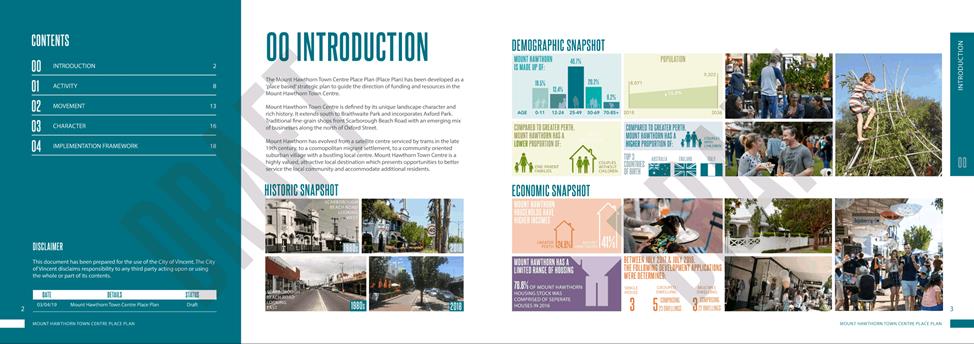
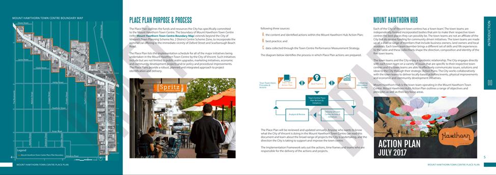
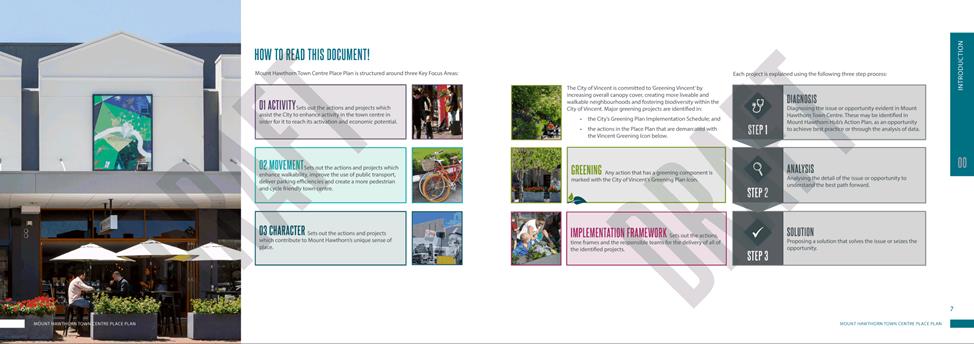
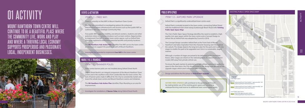
5.6 Mount Hawthorn Town Centre Place Plan
5.7 Place Plan Minor Annual Review
6 Infrastucture and Environment
6.1 Waste Strategy Project 2 - Bulk Hard Waste (Junk) Service Options Appraisal
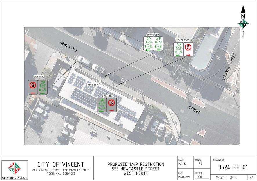
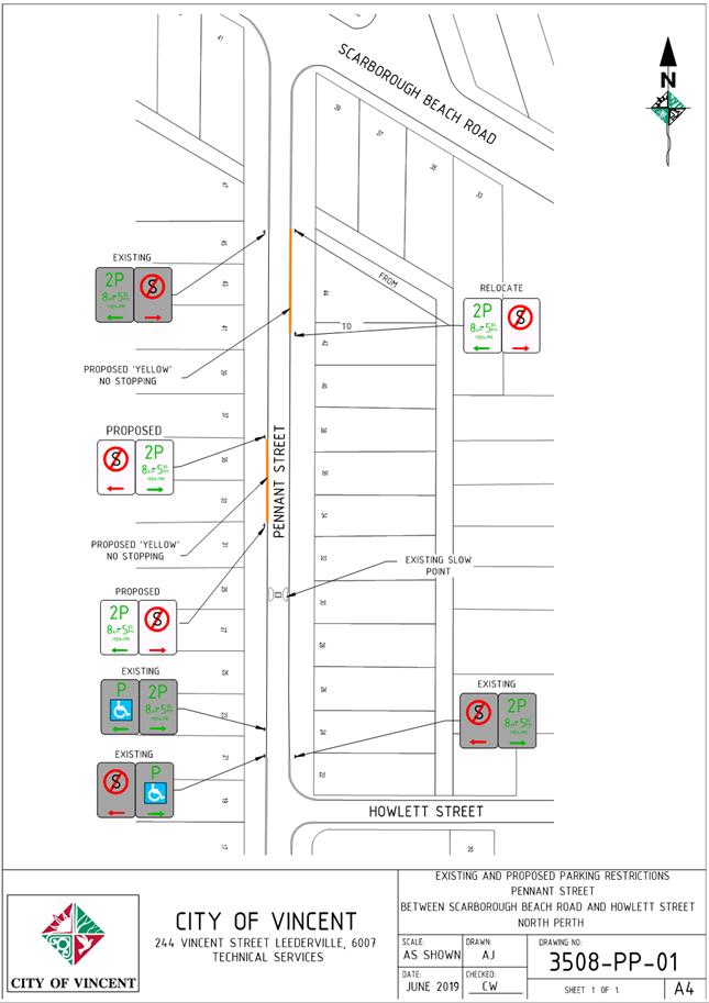
6.2 Minor Parking Restriction Improvements/Amendments
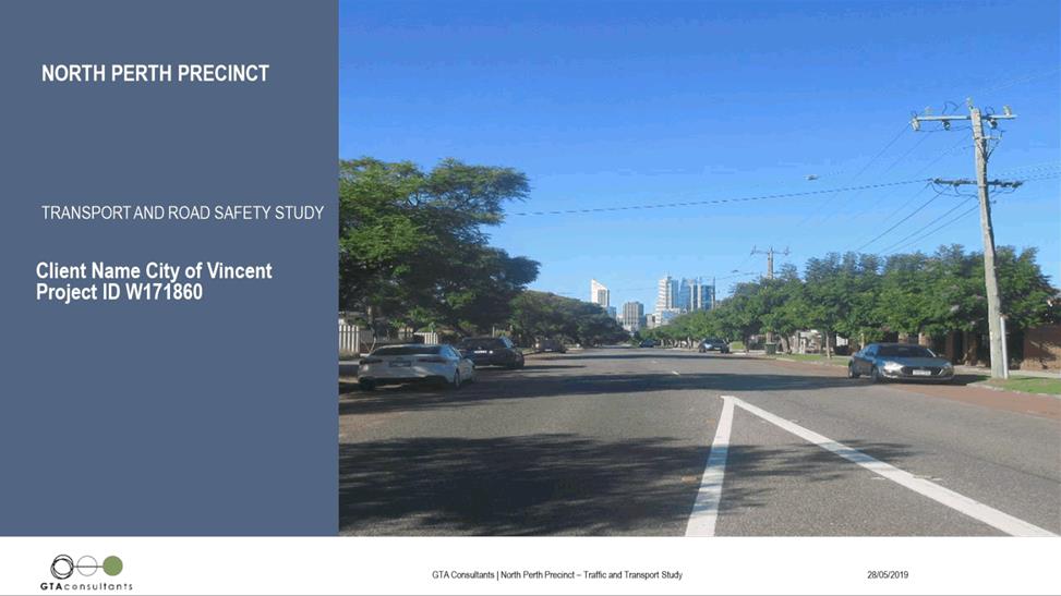
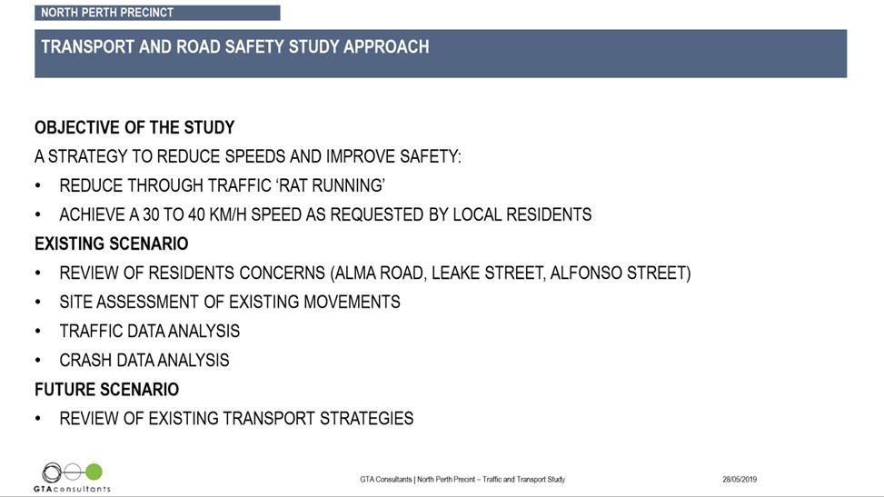
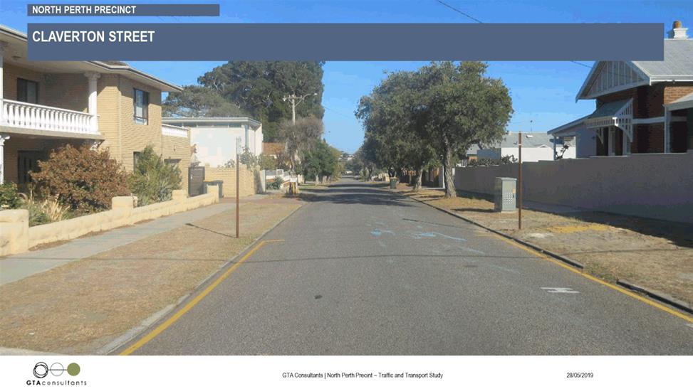
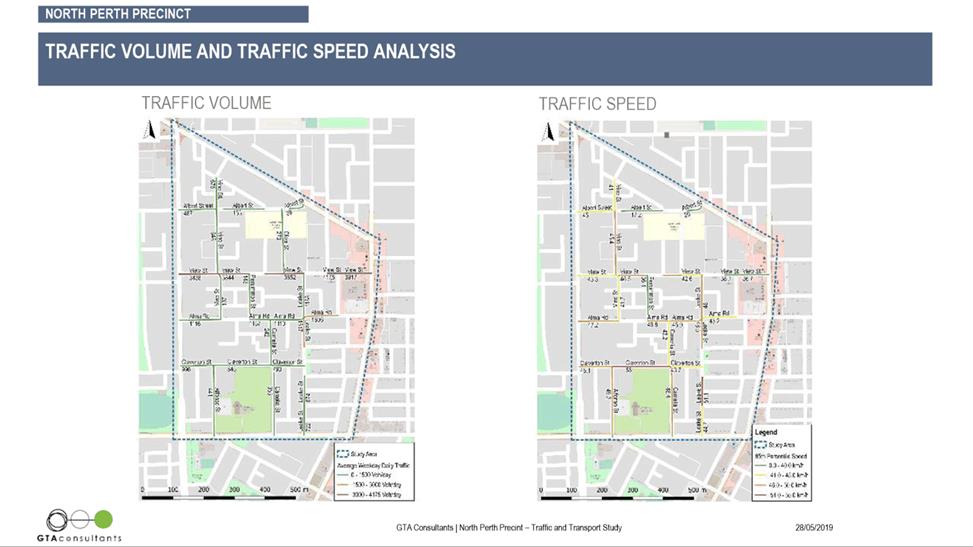
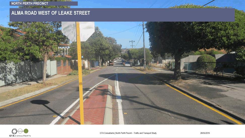
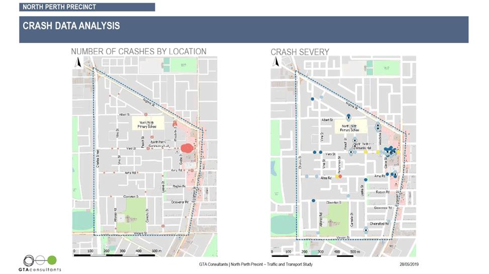
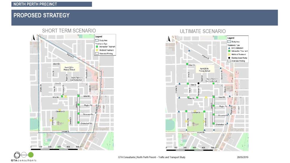
6.3 North Perth Precinct Traffic Study
7 Community and Business Services
7.1 LATE REPORT: Investment Report as at 31 May 2019
7.2 LATE REPORT: Authorisation Expenditure for the Period 1 May to 31 May 2019
7.3 LATE REPORT: Financial Statements as at 31 May 2019
7.4 LATE REPORT: Adoption of 2019/2020 Annual Budget
7.5 Amendments to the Parking and Parking Facilities Local Law 2007
7.6 LATE REPORT: City Homelessness Framework Committee - Draft Action Plan
7.7 LATE REPORT: Floreat Athena Football Club - Litis Stadium Lease - Progress Report
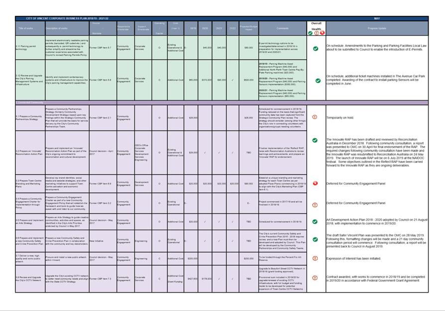
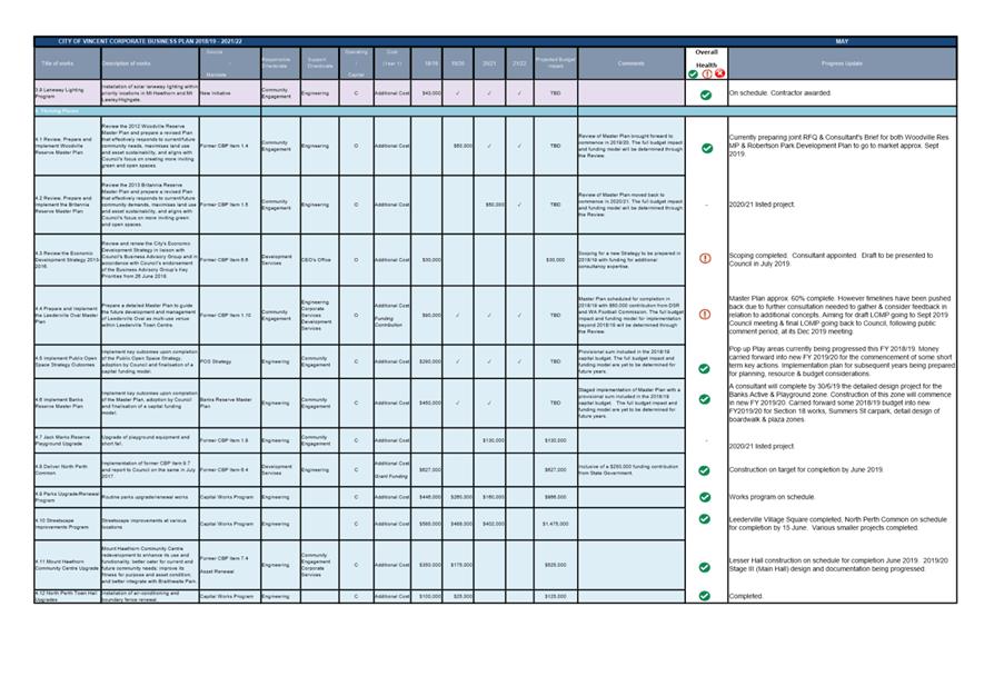
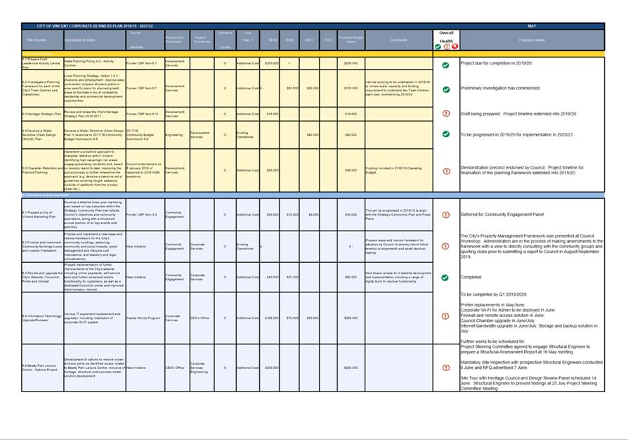
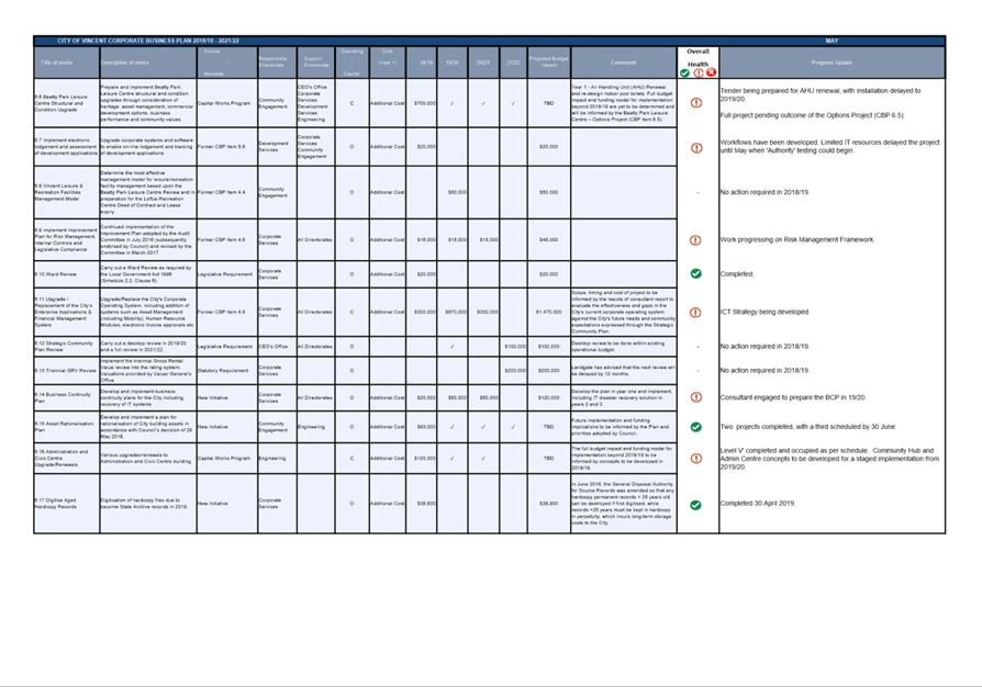
8.1 Corporate Business Plan Progress Update
8.2 Community Budget Submissions 2019/20
8.3 Monthly review of policies in accordance with the City's Policy Review Plan
8.5 Annual review of Council delegations
8.6 Appointment of an alternative member for the Mindarie Regional Council meeting - 4 July 2019
8.7 LATE REPORT: Report and Minutes of Audit Committee meeting held on 9 April 2019
9 Motions of Which Previous Notice Has Been Given
10 Representation on Committees and Public Bodies
“The City of Vincent would like to acknowledge the Traditional Owners of the land, the Whadjuk people of the Noongar nation and pay our respects to Elders past, present and emerging”.
2 Apologies / Members on Leave of Absence
Nil
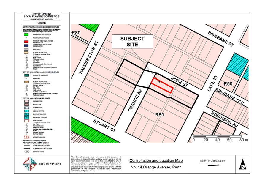
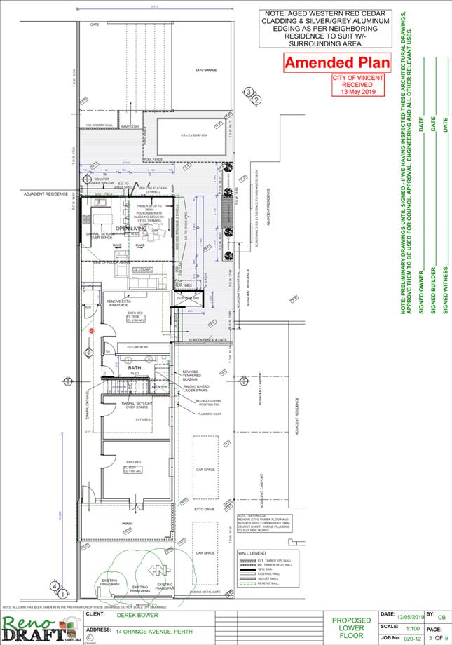
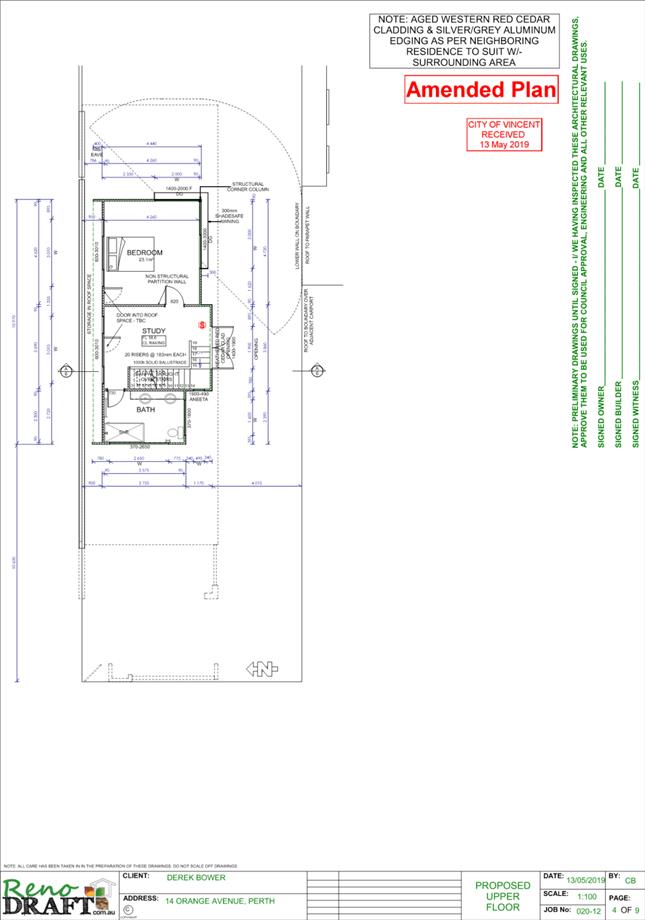
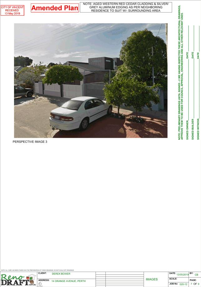
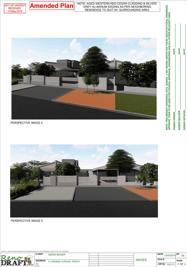
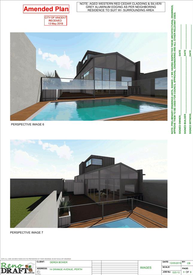
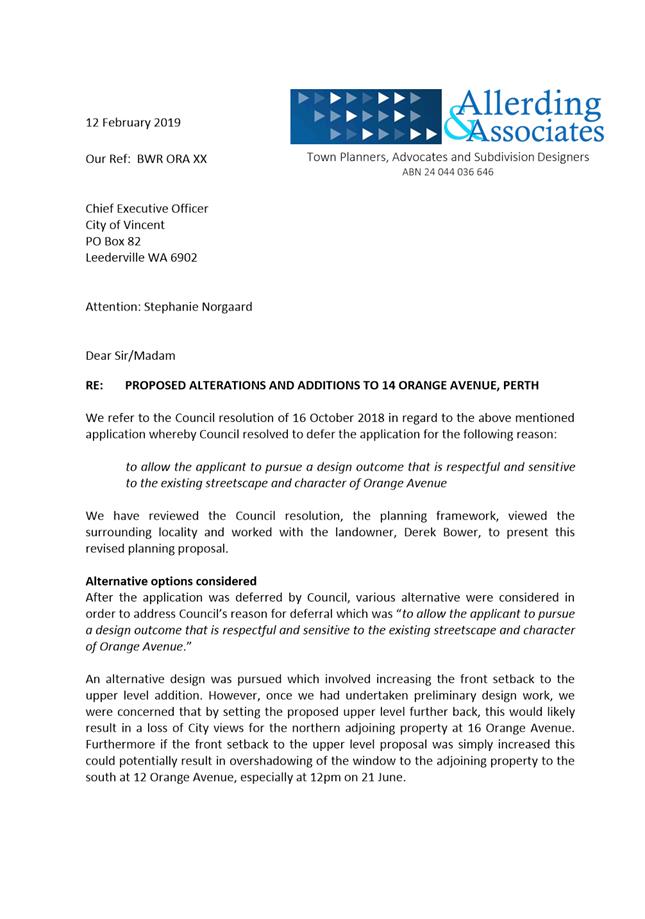
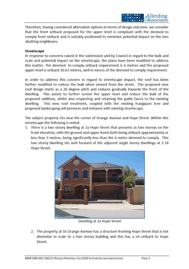
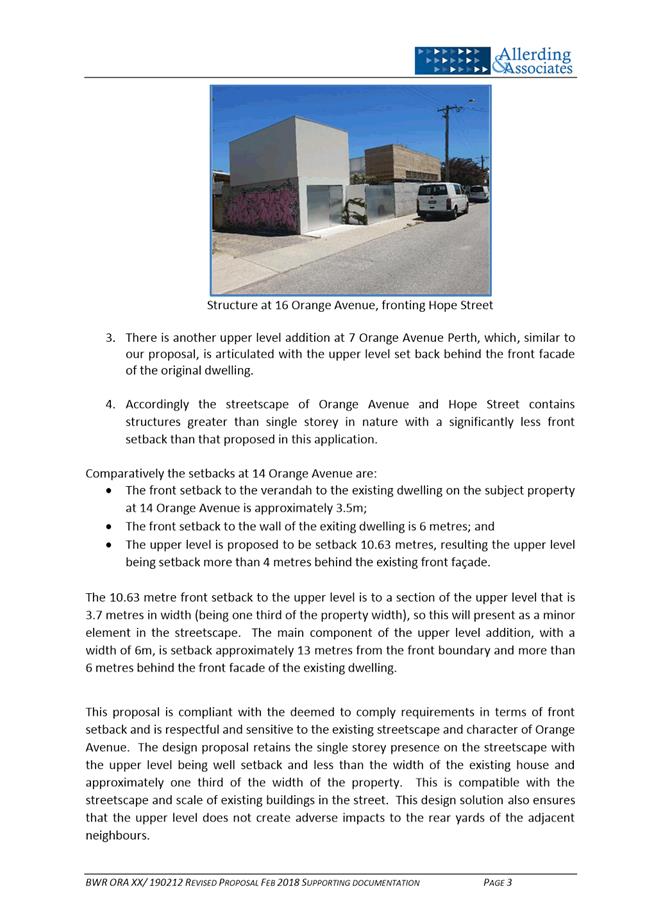
5.1 No. 14 (Lot: 1; SP: 12592) Orange Avenue, Perth - Second Storey Addition and Alterations to Single Dwelling
TRIM Ref: D19/40441
Author: Clair Morrison, Urban Planner
Authoriser: John Corbellini, A/Executive Director Planning and Place
Ward: South
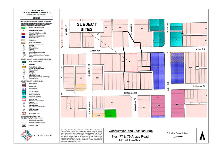
Attachments: 1. Consultation
and Location Map ⇩ ![]()
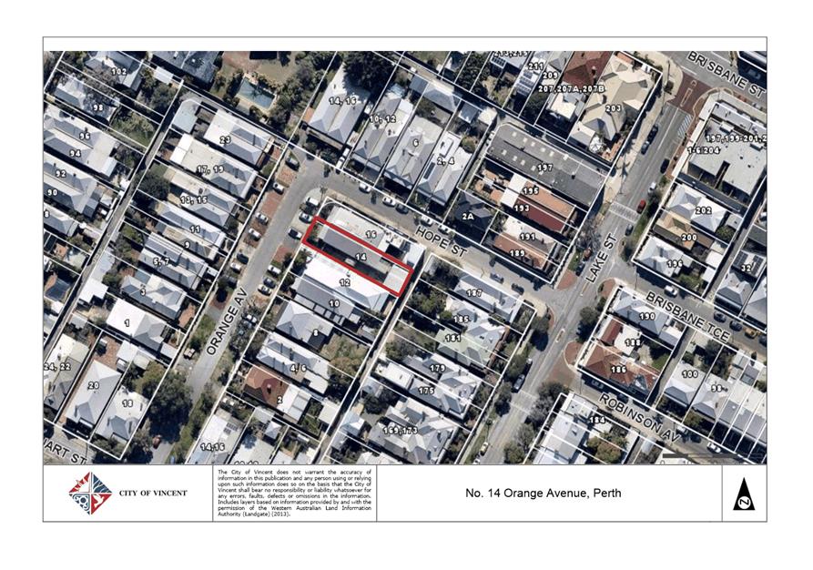
2. Development
Application Plans ⇩ ![]()
3. Applicant's
Justification ⇩ ![]()
4. Administration's
Response to Summary of Submissions ⇩ ![]()
5. Applicant's
Response to Summary of Submissions ⇩ ![]()
6. Determination
Advice Notes ⇩ ![]()
|
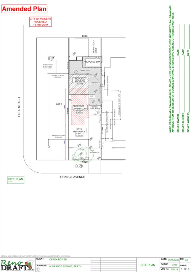
That Council, in accordance with the provisions of the City of Vincent Local Planning Scheme No. 2 and the Metropolitan Region Scheme, APPROVES the development application for a Second Storey Addition to a Single Dwelling at No. 14 (Lot: 1; SP: 12592) Orange Avenue, Perth in accordance with the plans shown in Attachment 2, subject to the following conditions, with the associated determination advice notes in Attachment 6: 1. Extent of Approval This approval only relates to the ‘PROPOSED ADDITION’ and ‘PROPOSED UPPER FLOOR’ to Single Dwelling shown on the approved plans dated 13 May 2019 and does not relate to the ‘PROPOSED SPA’, ‘TIMBER DECK’, ‘EXISTING STUDIO/SHED’ or any other development on the lot, and does not relate to the use of the site for anything other than a Single Dwelling; 2. Landscaping 2.1 A detailed landscape and reticulation plan for the development site and adjoining road verge to the City’s satisfaction is be lodged with and approved by the City prior to commencement of the development. The plan shall be drawn to a scale of 1:100 and show the following: · The location and type of existing and proposed trees and plants, with the proposed tree in the front setback area to be based on the City’s tree selection tool; · Areas to be irrigated or reticulated; and · The provision of a minimum 30 percent Canopy Coverage and the inclusion of an additional tree, within the front setback area, as defined by the City’s Policy No. 7.1.1 – Built Form; and 2.2 All works shown in the plans as identified in Condition 2.1 above shall be undertaken in accordance with the approved plans to the City’s satisfaction, prior to occupation or use of the development and shall be maintained thereafter to the satisfaction of the City at the expense of the owners/occupiers; 3. External Fixtures All external fixtures and building plant, including air conditioning units, piping, ducting and water tanks, shall be located so as to minimise any visual and noise impact on surrounding landowners, and shall be screened from view from the street, and surrounding properties to the satisfaction of the City; and 4. Stormwater All stormwater produced on the subject land shall be retained on site, by suitable means to the full satisfaction of the City. |
Purpose of Report:
To consider an application for development approval for a second storey addition and alterations to an existing Single Dwelling at No. 14 Orange Avenue, Perth (subject site).
PROPOSAL:
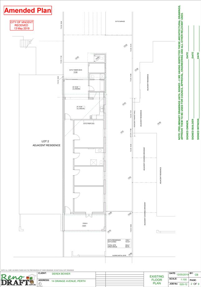
The application proposes ground floor alterations and a second storey addition to an existing Single Dwelling.
Background:
|
Landowner: |
Derek Bower |
|
Applicant: |
Derek Bower |
|
Date of Application: |
2 August 2018 |
|
Zoning: |
MRS: Urban LPS2: Zone: Residential R Code: R50 |
|
Built Form Area: |
Residential |
|
Existing Land Use: |
Single Dwelling |
|
Proposed Use Class: |
P |
|
Lot Area: |
362 square metres |
|
Right of Way (ROW): |
Yes – 3 metres wide, drained and sealed |
|
Heritage List: |
No |
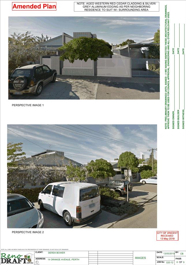
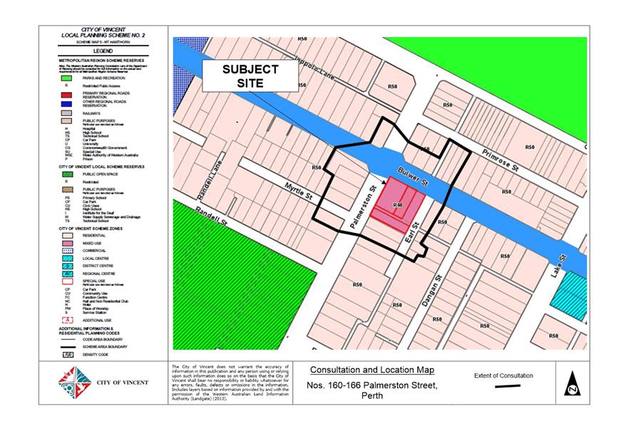
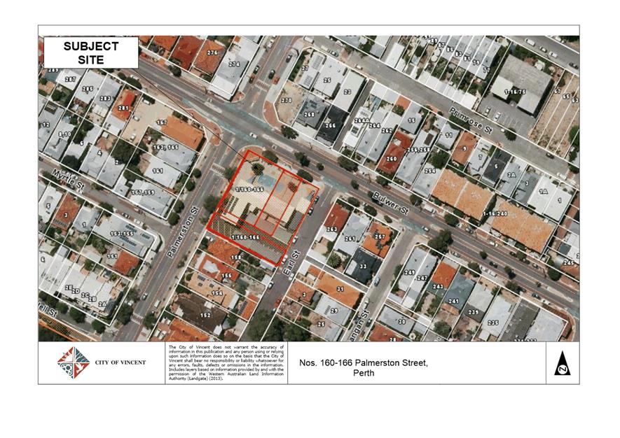
The subject site is located at No. 14 Orange Avenue, Perth, as shown in the location plan included as Attachment 1. The site is bound by Orange Avenue to the west, a right of way to the east and residential properties to the north and south. The subject site comprises of an existing single storey dwelling, which shares a common wall and roof with No. 16 Orange Avenue.
Orange Avenue has been developed with predominantly ‘terrace style’ single storey single houses and grouped dwellings. There are two storey developments including multiple dwellings and commercial developments within the broader area. There are a number of Heritage Listed dwellings located to the east of the subject site (fronting Lake Street) on the opposite side of the right of way.
The subject site is zoned Residential with a density code of R50 under the City’s Local Planning Scheme No. 2 (LPS2). The subject site is located within the ‘Residential’ Built Form Area under the City’s Policy No. 7.1.1 – Built Form (Built Form Policy) and has been assessed against the applicable standards and requirements of the policy.
A previous development application was presented to Council at its Ordinary Council Meeting on 4 April 2018. The application was deferred by Council to enable the applicant time to address Council’s concerns relating to streetscape, setbacks, bulk and scale and visual privacy.
An amended version of the application was presented to Council at its Ordinary Council Meeting on 26 June 2018. The application was refused by Council on the basis that the building height and proposed northern setback were considered to have a detrimental impact on the streetscape.
Following the refusal, the applicant lodged a new development application which differed from the refused application in relation to the building height, landscaping and colours and materials proposed. This application was presented to Council at its Ordinary Council meeting on 16 October 2018. Council resolved to defer its decision on the amended development plans to allow the applicant time to pursue a design outcome that is sensitive to the existing streetscape and character of Orange Avenue.
An amended version of the application was presented to Council at its Ordinary Council Meeting on 5 March 2019. The amended version of the application proposed plans that increased the roof height of the existing dwelling on the ground level to partially screen the second storey addition from the street and southern boundary. Council resolved to defer the application “to enable the applicant to further pursue a design outcome that is sensitive to the existing streetscape and character of Orange Avenue”.
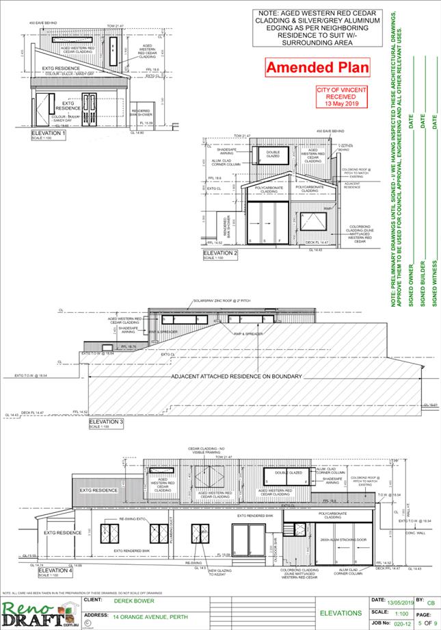
Following Council’s deferral, the applicant submitted an application for review with the State Administrative Tribunal (SAT) for the deemed refusal of the application. Administration and the Chair of the City’s Design Review Panel (DRP) attended a mediation session on 3 May 2019. At this mediation session, the SAT invited the application to provide the City with revised plans and for the City to consider these plans and reconsider the deemed refusal on or before 25 June 2019, pursuant to Section 31 of the State Administrative Tribunal Act 2004. Following the mediation session the applicant provided revised development plans, which are included as Attachment 2. The revised plans included the follow changes to the previous proposal deferred by Council:
· The proposed tapering of the existing roof form from the front of the dwelling to the addition has been removed, with the existing roof form retained;
· The design off the addition has been changed from exposed tapered skillion roof with eaves to a concealed roof and eaves that presents as a flat single contemporary addition;
· One single cladding material aged western red cedar cladding, is now proposed for the addition, rather than the two cladding materials previously proposed; and
· The front facing windows are now proposed to be the same slimline design, on horizontal and one vertical.
There are no further departures from the deemed-to-comply standards as a result of these revisions. The applicant’s justification for the revised proposal is included as Attachment 3.
Details:
Summary Assessment
The table below summarises the planning assessment of the proposal against the provisions of the City of Vincent LPS2, the City’s Built Form Policy, Policy No. 7.6.1 – Heritage Management – Development Guidelines for Heritage and Adjacent Properties and the State Government’s Residential Design Codes (R Codes). In each instance where the proposal requires the discretion of Council, the relevant planning element is discussed in the Detailed Assessment section following from this table.
|
Planning Element |
Use Permissibility/ Deemed-to-Comply |
Requires the Discretion of Council |
|
Land Use |
ü |
|
|
Street Setback |
ü |
|
|
Building Setbacks/Boundary Wall |
|
ü |
|
Building Height/Storeys |
ü |
|
|
Open Space |
ü |
|
|
Outdoor Living Areas |
ü |
|
|
Landscaping (R Codes) |
ü |
|
|
Privacy |
ü |
|
|
Parking & Access |
ü |
|
|
Solar Access |
ü |
|
|
Site Works/Retaining Walls |
ü |
|
|
External Fixtures |
ü |
|
|
Surveillance |
ü |
|
|
Impact on Adjacent Heritage Buildings |
ü |
|
Detailed Assessment
The deemed-to-comply assessment of the element which requires the discretion of Council is as follows:
|
Lot Boundary Setbacks |
|
|
Deemed-to-Comply Standard |
Proposal |
|
R Codes Clause 5.1.3
Southern Boundary Ground Level – 4.8 metres
Northern Boundary Level One – 1.5 metres |
Southern Boundary Ground Level – 3.8 metres
Northern Boundary Level One – 0.9 metres |
The above element of the proposal does not meet the specified deemed-to-comply standards and is discussed in the comments section below.
Consultation/Advertising:
Community consultation was undertaken in accordance with the Planning and Development (Local Planning Scheme) Regulations 2015, for a period of 14 days commencing on 29 August 2018 and concluding on 11 September 2018. Community consultation was undertaken by means of written notification being sent to surrounding landowners, as shown in Attachment 1 and a notice on the City’s website.
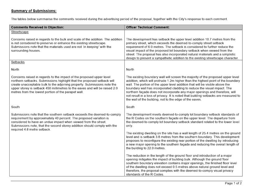
The City received two submissions in objection to the proposal during community consultation. Two submissions in objection to the proposal were also received after community consultation had concluded. A summary of submissions received and Administration’s response to these is included as Attachment 4. The applicant’s response to the summary of submission is included as Attachment 5.
Design Review Panel:
Referred to DRP: Yes
The application was referred to the Chair of the City’s Design Review Panel on 14 May 2019. The Chair provided the following comments on the proposal:
“The application has address the key items discussed with the applicant.
· The indentation of the stair from the existing lower roof has terminated the appearance of a two level façade;
· The rationalisation of the materials, window types and location has created a cohesive upper level.
In conclusion the above design refinements have produced a more cohesive design reducing the impact on the streetscape, it now sits comfortably with its surrounds.”
Legal/Policy:
· Planning and Development Act 2005;
· Planning and Development (Local Planning Schemes) Regulations 2015;
· State Administrative Tribunal Act 2004;
· City of Vincent Local Planning Scheme No. 2;
· State Planning Policy 3.1 – Residential Design Codes;
· Policy No. 4.1.5 – Community Consultation;
· Policy No. 7.1.1 – Built Form Policy; and
· Policy No. 7.6.1 – Heritage Management – Development Guidelines for Heritage and Adjacent Properties.
Delegation to Determine Applications:
The development application is being referred to Council as the proposal relates to a matter previously determined by Council.
Risk Management Implications:
There are minimal risks to Council and the City’s business function when Council exercises its discretionary power to determine a planning application.
Strategic Implications:
This is in keeping with the City’s Strategic Community Plan 2018-2028:
“Innovative and Accountable
We are open and accountable to an engaged community”.
SUSTAINABILITY IMPLICATIONS:
Nil.
Financial/Budget Implications:
Should the matter proceed to a full SAT hearing, the City may need to engage a consultant to assist. Such engagement would incur a cost for the City.
Comments:
Lot Boundary Setbacks
Northern Boundary
The proposal incorporates a 0.9 metre upper floor setback to the northern boundary in lieu of the deemed‑to‑comply standard of 1.5 metres.
· The subject site shares a 5.5 metres common boundary wall with the adjoining property to the north. The existing boundary wall would screen the majority of the proposed upper level addition, which would protrude 1.0 metres higher than the highest point of the boundary wall.
· The portion of the upper level addition that would be visible above the boundary wall would incorporate natural style cladding to reduce the visual impact. The northern façade does not incorporate any major openings and would not result in a loss of privacy.
· The development has setback the upper level addition 10.7 metres from the primary street, which exceeds the deemed-to-comply street setback requirement of 6.0 metres. The increased setback is considered to further reduce the visual impact of the lot boundary setback when viewed from the street.
· The proposed second storey has a simplistic design, with straight edged roof, natural cladding and slimline windows fronting the street and southern adjoining lot. These design elements are sympathetic to the street and adjoining properties.
· Additional landscaping in the front setback area, in the form of an acceptable tree species, in conjunction with the established frangipani trees would provide sufficient screening to the second storey addition from the street.
The proposed upper level lot boundary setback meets the design principles of the R Codes and is supported.
Southern Boundary
On the ground level, the proposal incorporates a 3.8 metre setback to the main building in lieu of the deemed-to-comply standard of 4.8 metres.
· The existing dwelling on the site has a wall length of 25.4 metres and is setback 3.8 metres from the southern boundary. This application proposes to reconfigure the existing rear portion of the dwelling by introducing a new major opening to the southern façade and reducing the length of the building to 22.0 metres and maintains the current setback of the exiting dwelling to the southern boundary.
· The reduction in the length of the ground floor and introduction of a major opening to a previously solid wall mitigates the impact of building bulk.
· The proposal complies with the visual privacy standards of Clause 5.4.1 of the R Codes.
· The proposal is also compliant with the overshadowing standards of Clause 5.4.2 of the R Codes.
The proposed ground level lot boundary setback meets the design principles of the R Codes and is supported.
Landscaping
The City’s Built Form Policy requires a minimum of 30 percent canopy cover be provided within the front setback area for applications that propose additions or alterations to existing buildings.
· The subject site has existing frangipani trees located within the front setback area, which currently provides 27.64 percent canopy cover within the front setback area. The frangipani trees would be capable of achieving the 30 percent canopy cover at full maturity and meets the relevant Policy requirement.
· The inclusion of additional tree species would further soften the view of the addition from the street. It is recommended that a condition be imposed to require a landscape plan to be submitted so that an appropriate tree species in like with the City’s recommended species could be provided.
Landscaping meets the design principles of the City Built Form Policy and is supported.
Streetscape and Character
The application was deferred by Council to allow the applicant time to pursue a design outcome that is sensitive to the existing streetscape and character of Orange Avenue. Following mediation, the applicant provided amended plans to address the concerns raised by Council and discussions held at the mediation Session. These amended plans were referred to the Chair of the DRP who advised that the new design is more cohesive and reduces the impact of the addition on the streetscape.
The application proposes a predominantly compliant development which either meets the deemed-to-comply standards or the design principles of the R Codes and Built Form Policy. The proposal has been assessed against the objectives of the R Codes, LPS2 (Residential zone) and matters to be considered under clause 67 of the Planning and Development (Local Planning Scheme Regulations) 2015 and is appropriate for the following reasons:
· The revised scale and mass of the second storey addition is now cohesive and is compatible with the area, providing a simple and natural design response for the locality and residential density;
· The subject site is afforded a two-storey building height under the deemed-to-comply standards of the City’s Built Form Policy;
· The development is located adjoining a property with a two storey component over both the dwelling and the garage; and
· The development preserves the existing dwelling located on the subject site and sets back the second storey addition 10.7 metres from the street. This preserves the character of the existing dwelling and contributes to the retention of the existing house stock within the locality. The development is sympathetic to the streetscape due to the now cohesive and simple design and natural material features.
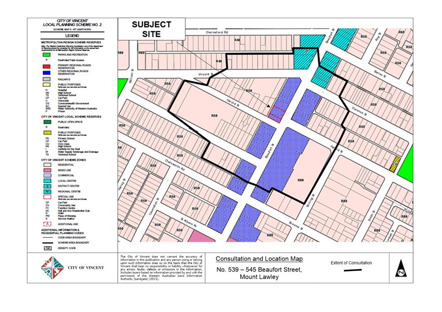
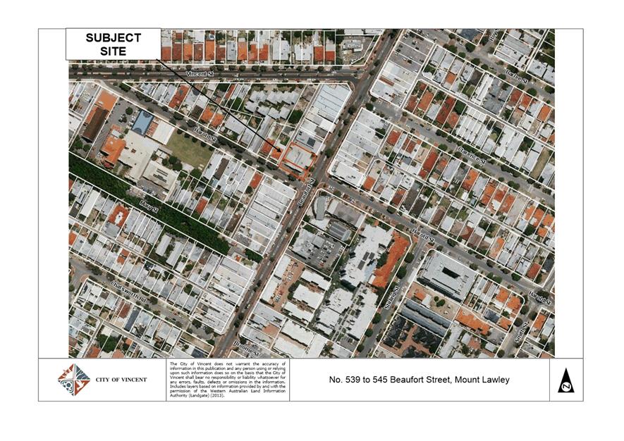
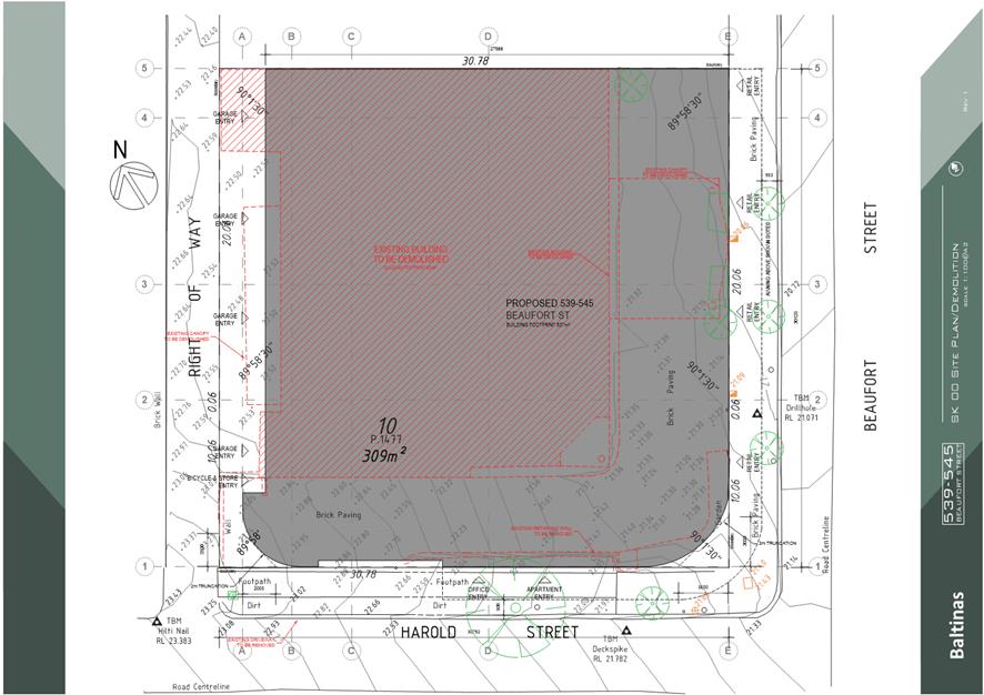
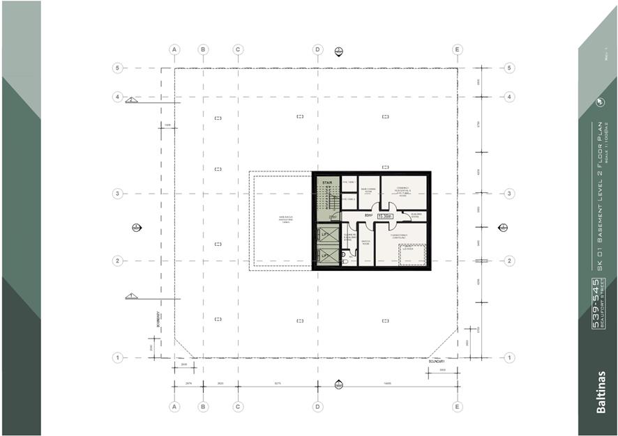
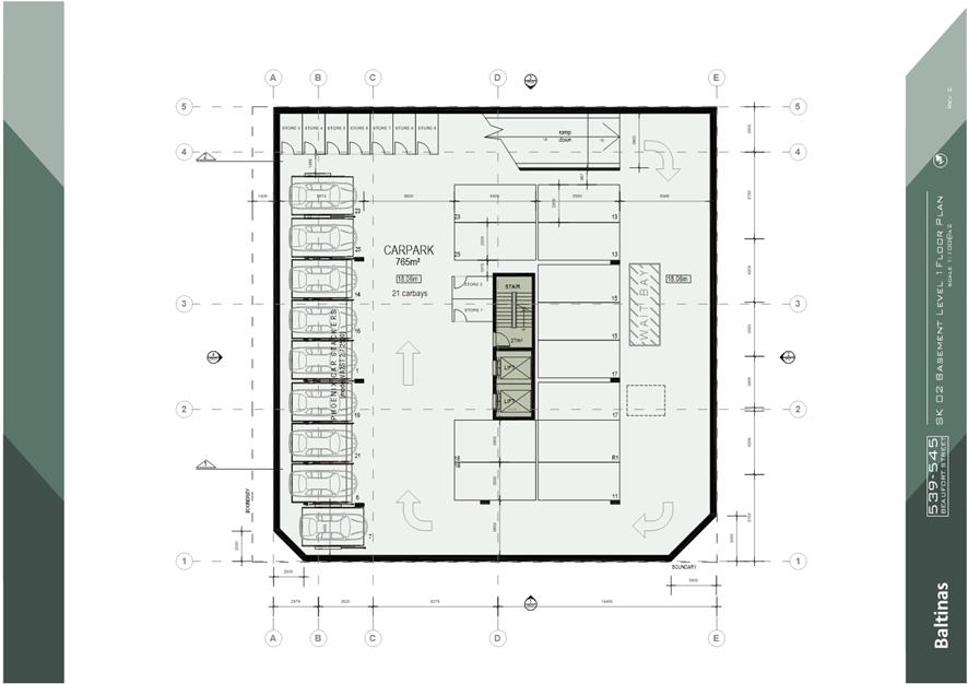
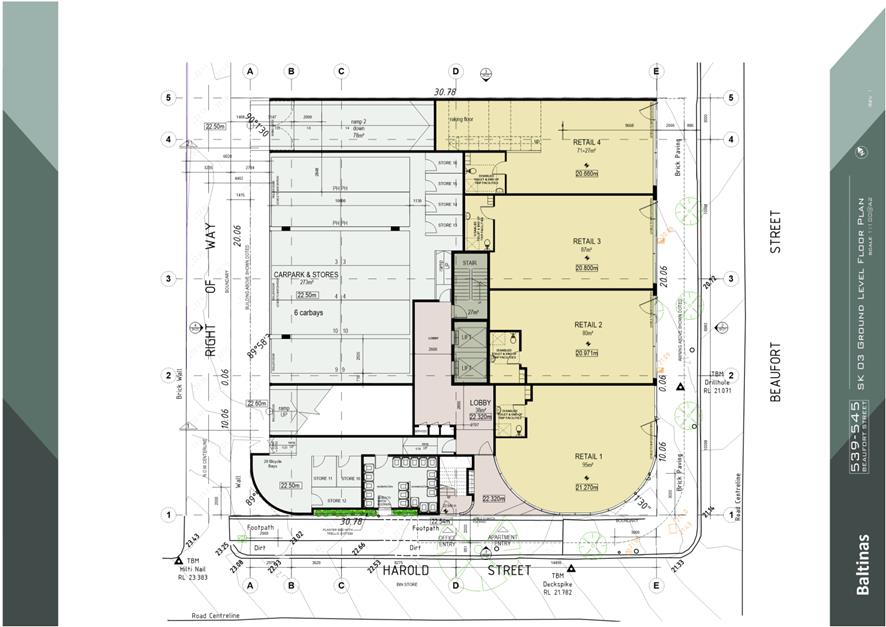
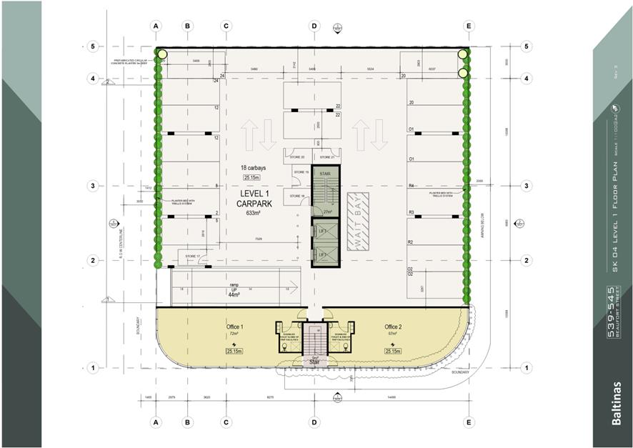
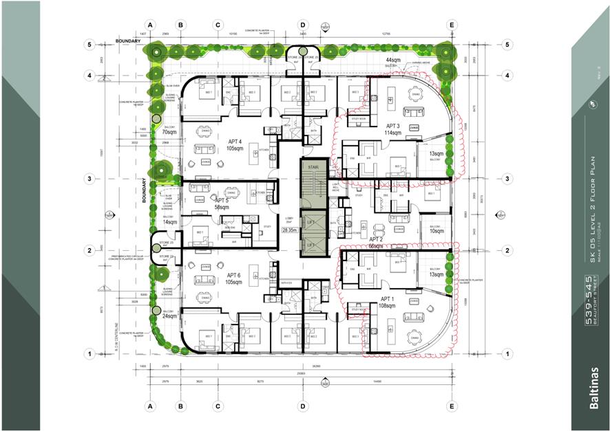
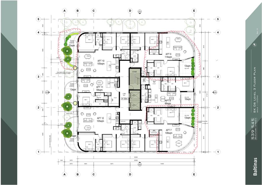
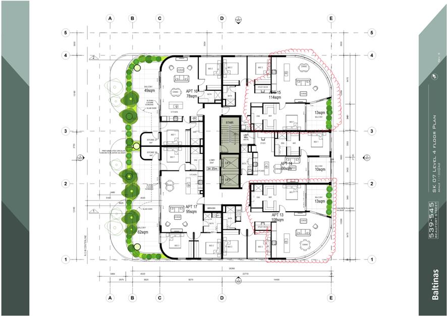
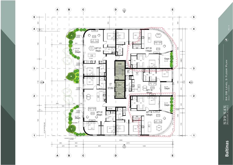
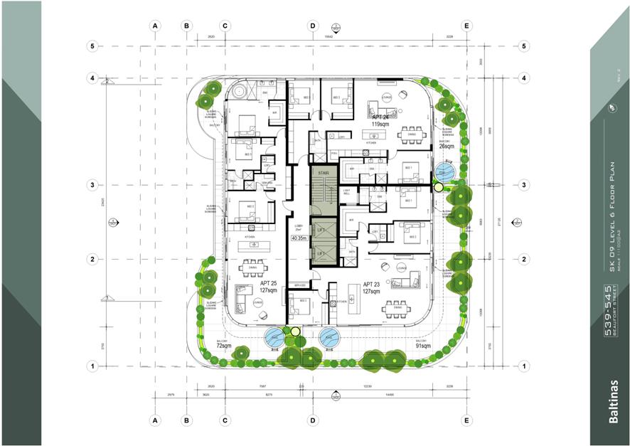
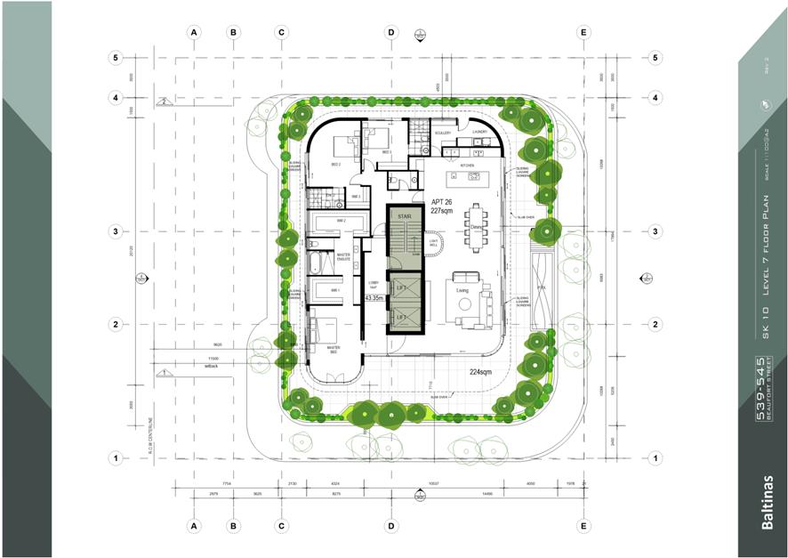
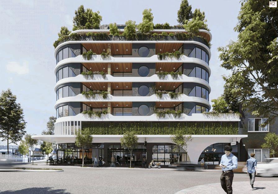
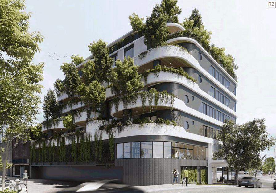
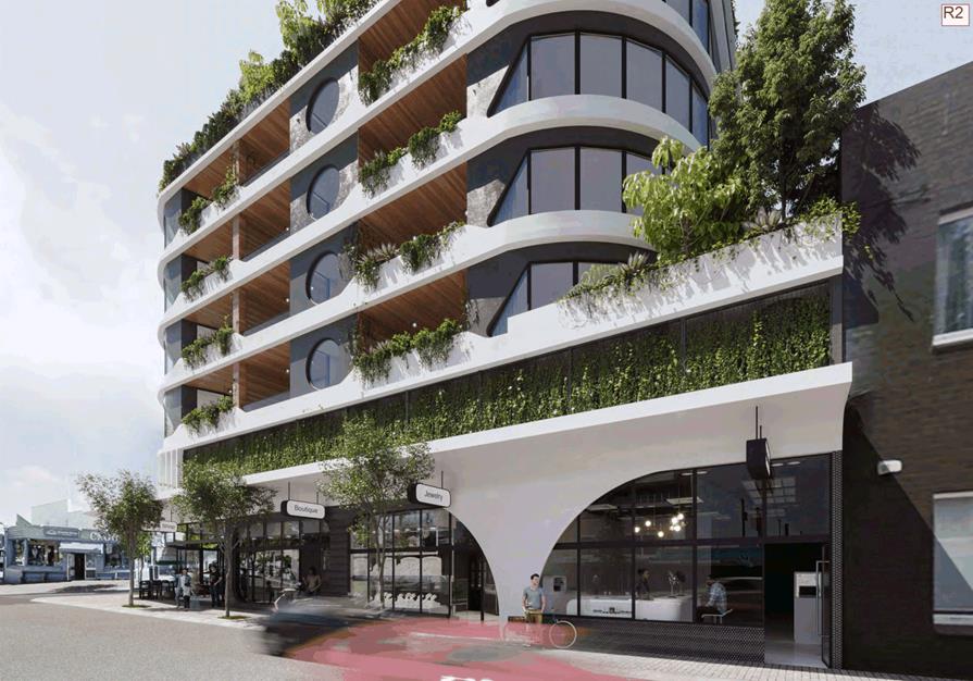
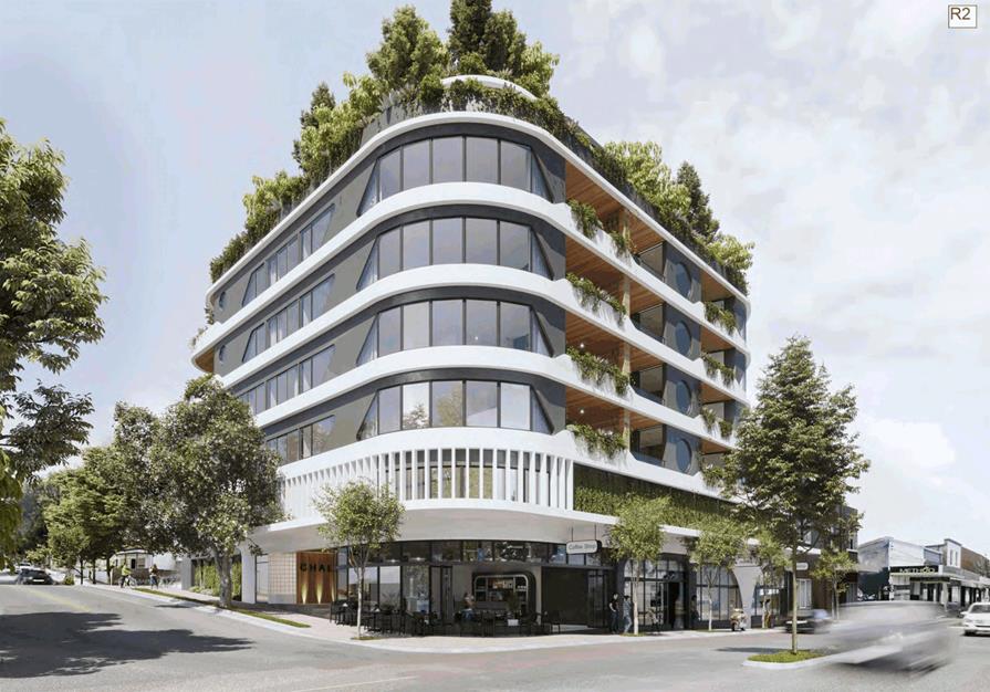
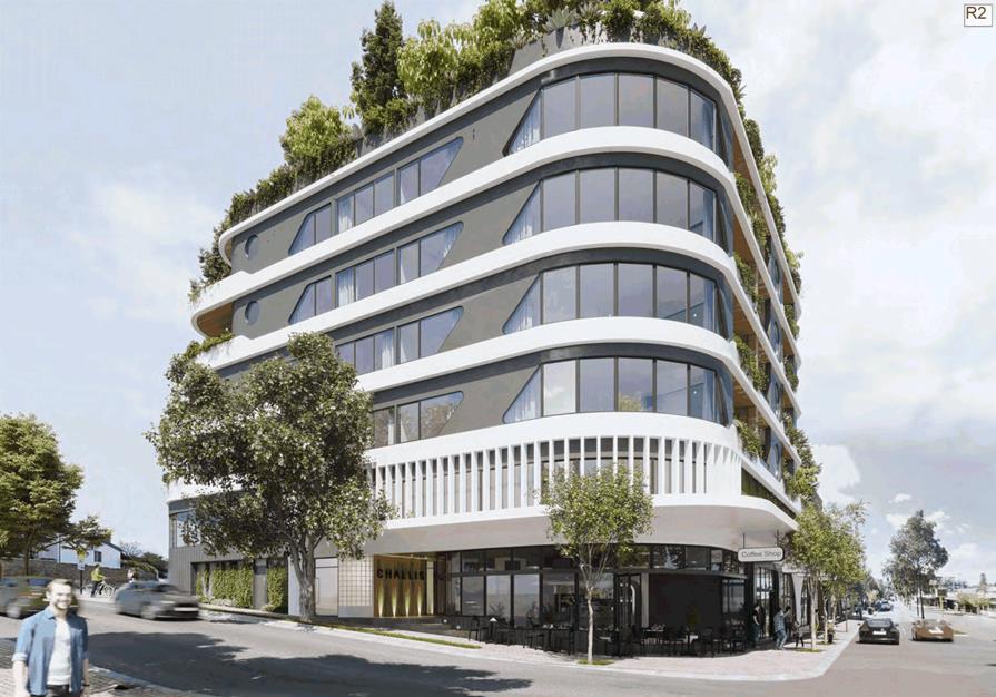
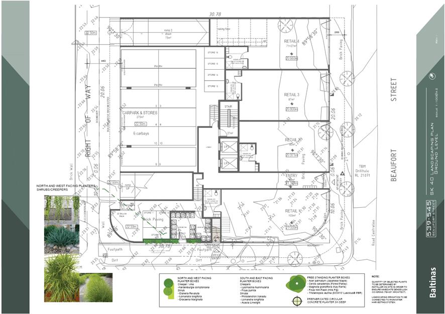
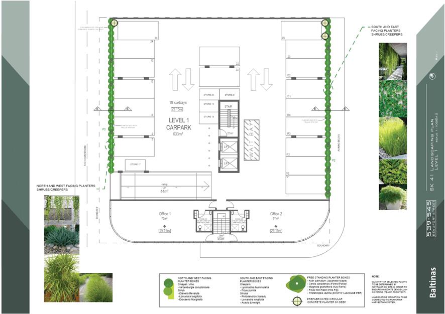
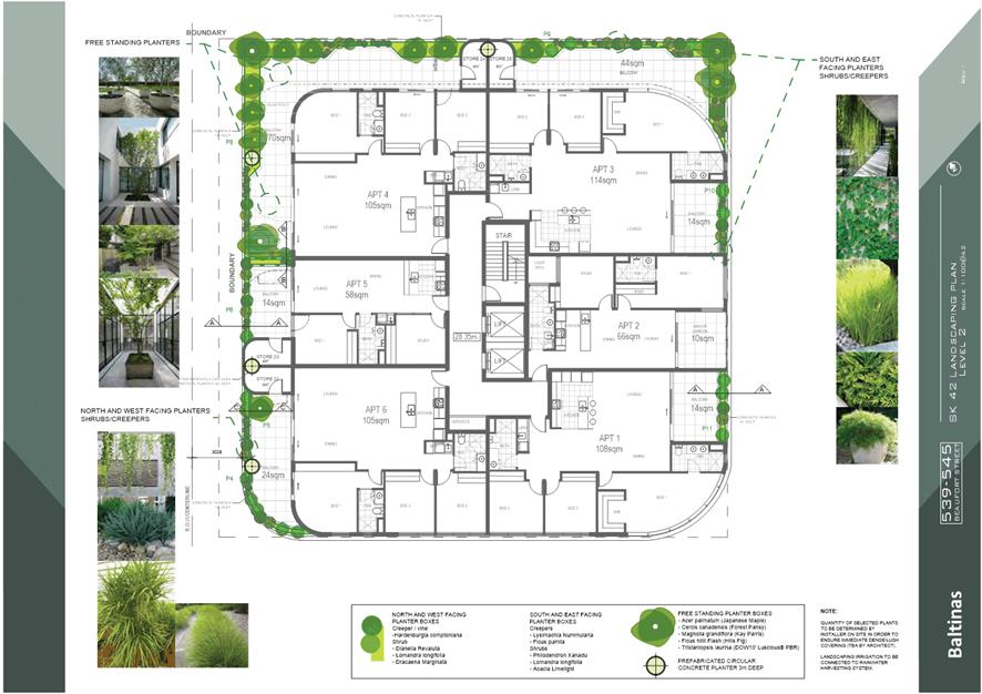
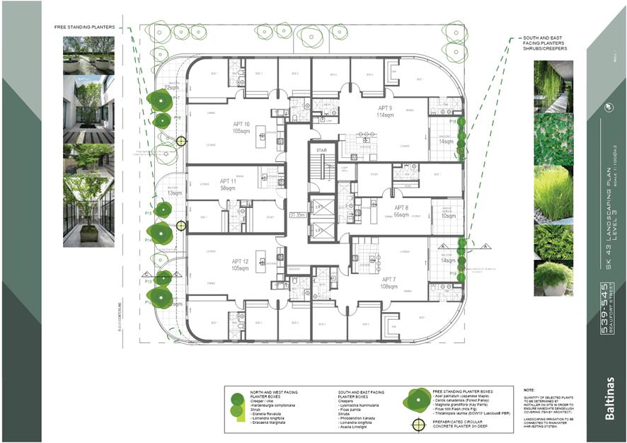
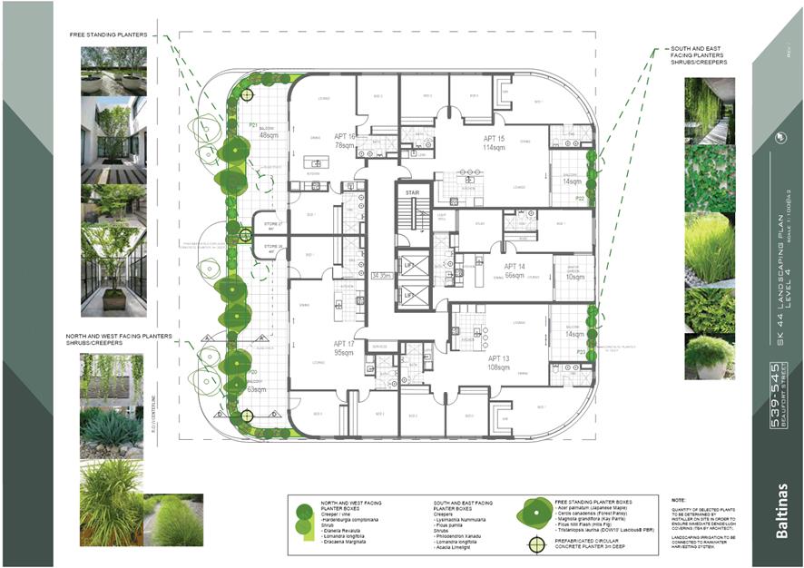
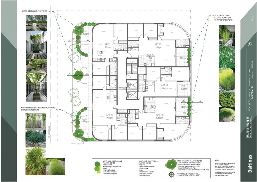
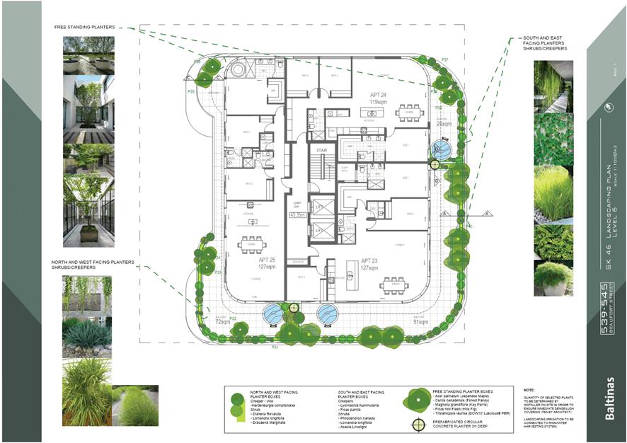
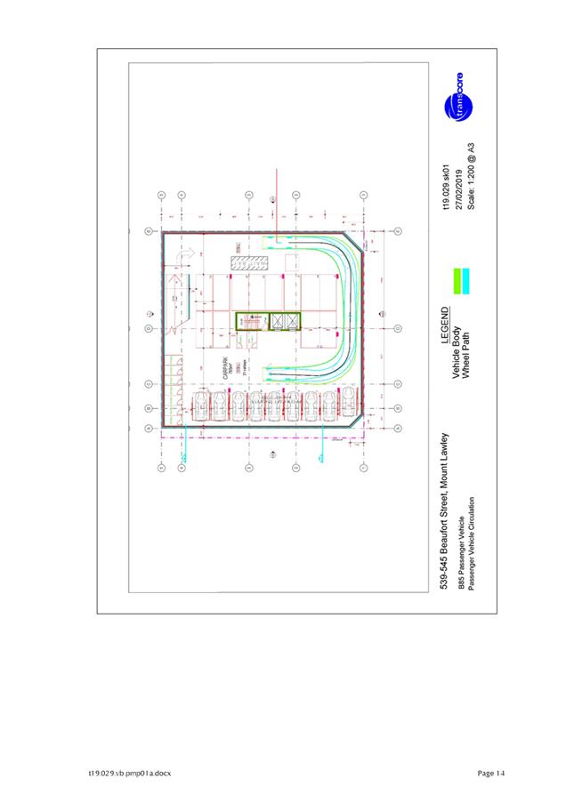
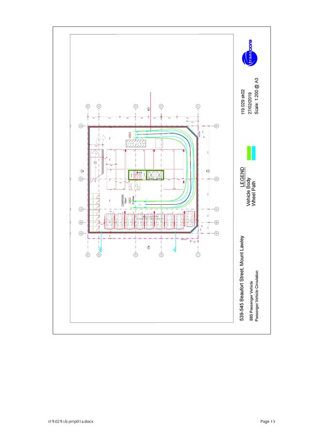
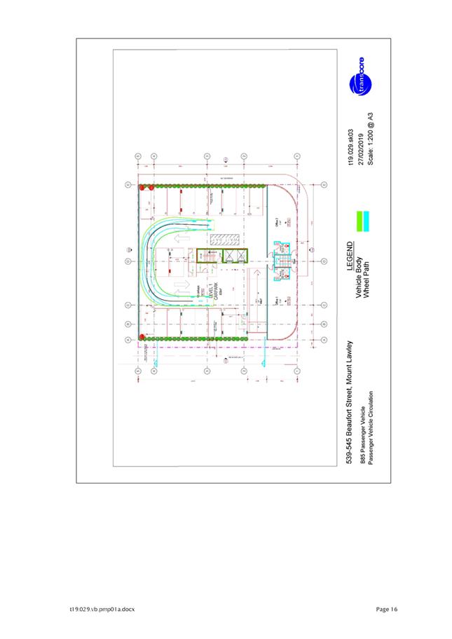
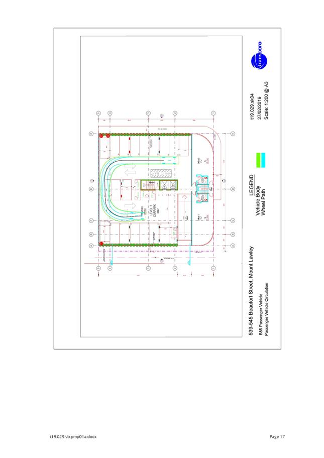
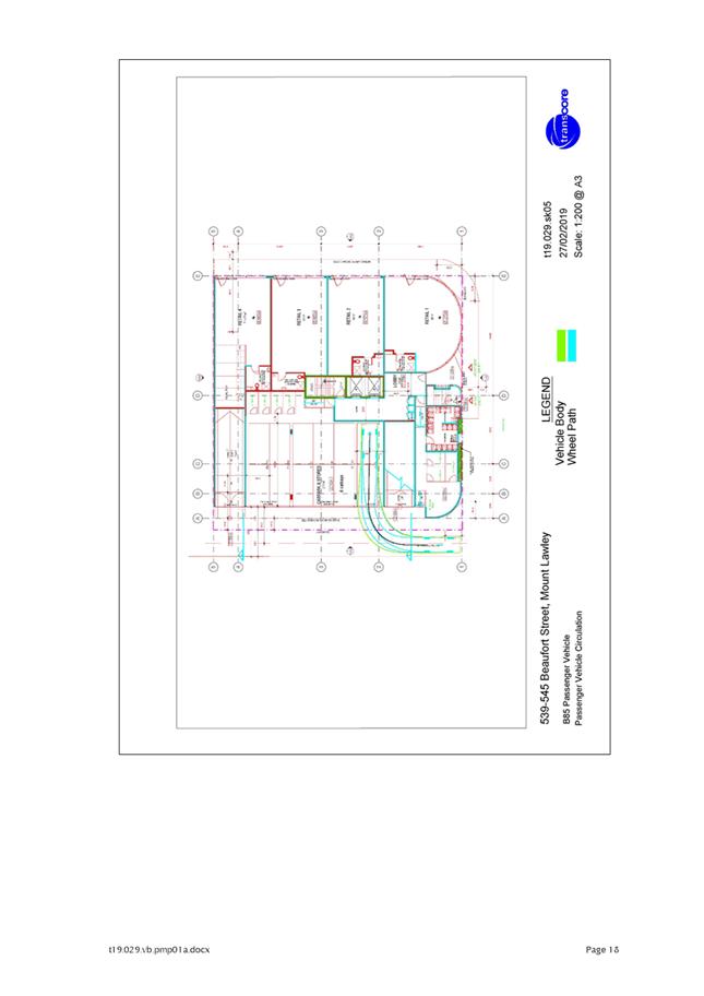
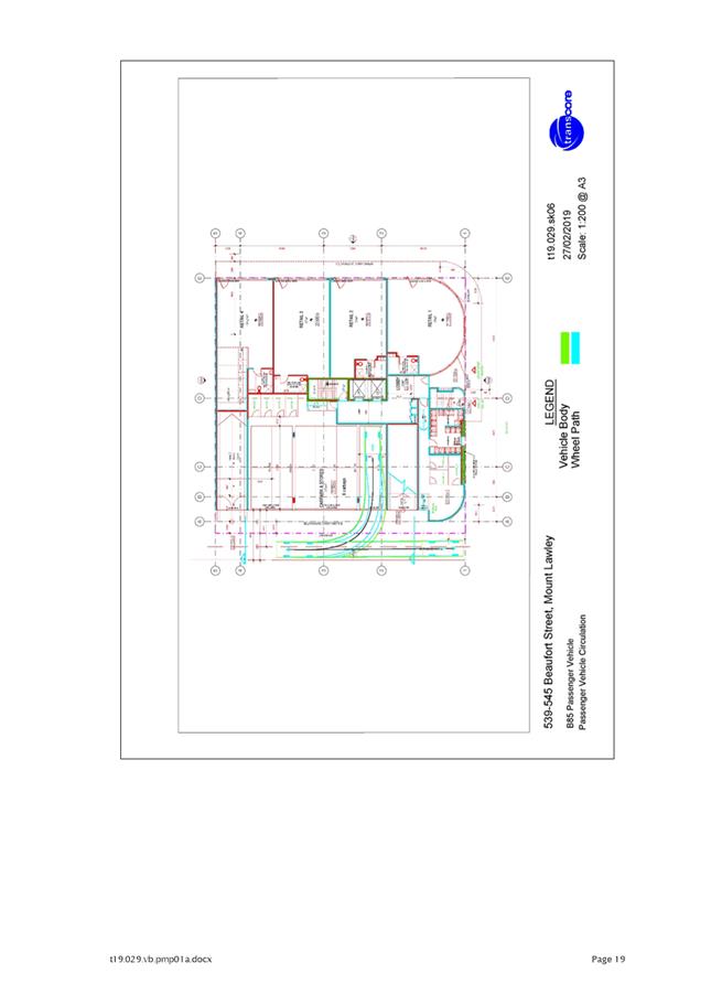
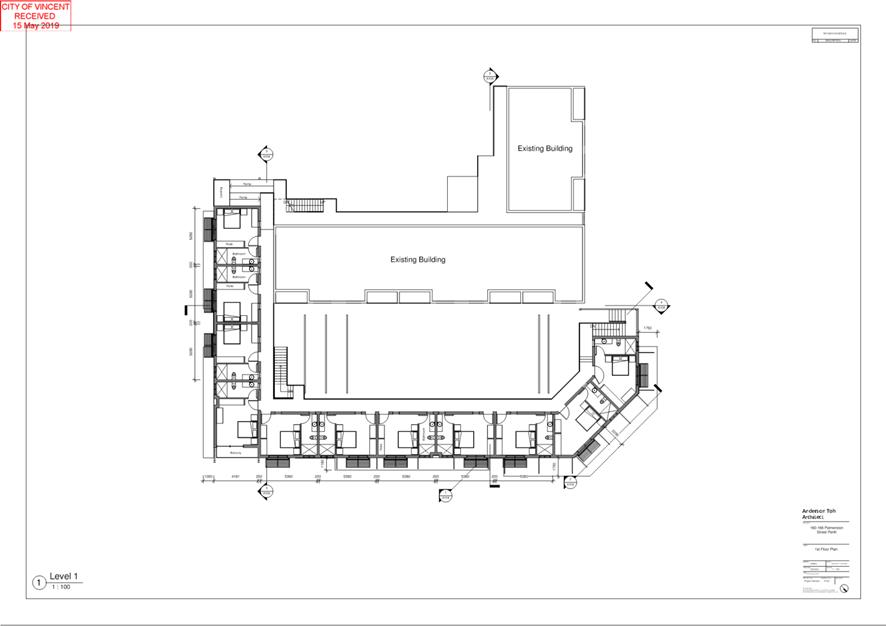
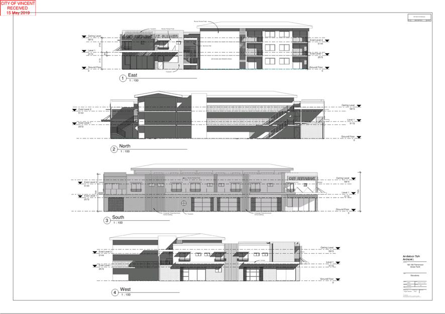
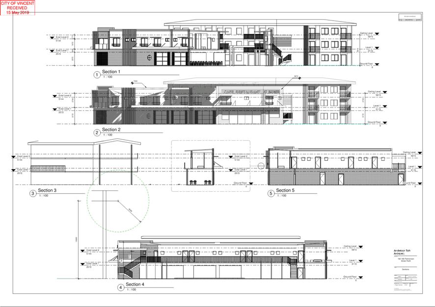
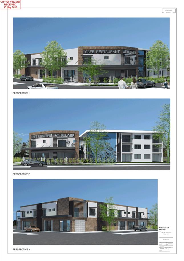
5.2 Nos. 539 - 545 (Lots 9, 10 and 30; D/P 1477 and 49374) Beaufort Street, Mount Lawley - Eight Storey Mixed Use Development
TRIM Ref: D19/40344
Author: Mitchell Hoad, Senior Urban Planner
Authoriser: John Corbellini, A/Executive Director Planning and Place
Ward: 600
Attachments: 1. Consultation
and Location Map ⇩ ![]()
2. Development Plans
⇩ ![]()
3. Supporting
Technical Reports ⇩ ![]()
4. Administration's
Response to Summary of Submissions ⇩ ![]()
5. Applicant's
Response to Summary of Submissions ⇩ ![]()
6. Design Review
Panel Minutes and Applicant's Response ⇩ ![]()
7. Determination
Advice Notes ⇩ ![]()
|
That Council in accordance with the provisions of the City of Vincent Local Planning Scheme No. 2 and the Metropolitan Region Scheme, APPROVES the application for development approval for an Eight Storey Mixed Use Development at Nos. 539-545 (Lots: 9, 10 and 30 D/P: 1477 and 49374) Beaufort Street, Mount Lawley, in accordance with the plans shown in Attachment 2 subject to the following conditions, with the associated advice notes in Attachment 7: 1. Use of Premises The use of the tenancies on the ground floor indicated as ‘Retail’ and the ‘Office’ indicated on the second storey of the approved plans shall only be used in accordance with the definitions of Shop and Office within the City of Vincent Local Planning Scheme No. 2 respectively as follows: Office means premises used for administration, clerical, technical, professional or similar business activities. Shop means premises other than a bulky goods showroom, a liquor store – large or a liquor store – small used to sell goods by retail, to hire goods, or to provide services of a personal nature, including hairdressing or beauty therapy services; 2. Amalgamation Prior to the occupation of the development, the subject land shall be amalgamated into one lot on the Certificate of Title; 3. Car Parking, Access and Bicycle Facilities 3.1 A minimum of 41 parking bays for the residents of the Multiple Dwellings, 4 visitor bays for visitors of the Multiple Dwellings, 4 bays for the Office tenancies and 4 bays for the Shop tenancies shall be provided on the site; 3.2 The visitor bays shall be marked and clearly signposted as dedicated for visitor use only, to the satisfaction of the City; 3.3 The 1.4 metre setback to the adjoining right of way shall be ceded free of costs to the Crown for the purpose of widening at the time of subdivision or amalgamation of the land, including Built Strata subdivision; 3.4 A 3 metre by 3 metre truncation shall be provided at the junction of Harold Street and Beaufort Street; 3.5 A 2 metre by 2 metre truncation shall be provided at the junction of Harold Street and the 1.4 metre setback to the right of way detailed in Condition 3.3 above; 3.6 Vehicle and pedestrian access points shall match into existing footpath levels to the satisfaction of the City; 3.7 Redundant vehicle crossover(s) shall be removed and the kerbing, verge and footpath reinstated to the satisfaction and specification of the City; 3.8 The 1.4 metre right of way setback area referred to in Condition 3.3 above, as well as all car parking and access areas shall be sealed, drained, paved and line marked in accordance with the approved plans and are to comply with the requirements of AS2890.1 to the satisfaction of the City prior to the occupation or use of the development; 3.9 The car park shall be used only by owners, visitors and tenants directly associated with the development; and 3.10 A minimum of 26 bike racks shall be provided for within the development. Bicycle racks shall be designed in accordance with AS2890.3 and installed prior to occupation to the satisfaction of the City. 8 of these bike racks shall be located to be accessible for visitors of the Multiple Dwellings and customers of the Shop and Office uses; 4. Parking Management Plan 4.1 Prior to the occupation of the development, a Parking Management Plan to the satisfaction of the City shall be submitted to and approved by the City. The Parking Management Plan shall include, but not be limited to, addressing the following: · Detailed management measures for the operation of the vehicular entry gate, to ensure access is readily available for owners/visitors/tenants to the residential and non-residential units at all times; and · Reciprocal car parking arrangements for the eight non-residential bays for use by visitors of the Multiple Dwellings outside of business hours; and 4.2 The Parking Management Plan as identified in Condition 4.1 above shall be implemented, and the development shall be carried out in accordance with the approved Parking Management Plan and approved plans, to the satisfaction of the City at the expense of the owners/occupiers; 5. Stormwater All stormwater produced on the subject land shall be retained on site, by suitable means to the full satisfaction of the City; 6. Verge Infrastructure No verge tree shall be removed without the prior written approval of the City. The verge tree shall be retained and protected from damage including unauthorised pruning to the satisfaction of the City; 7. Building Design 7.1 Windows and doors of the ground floor tenancies fronting Beaufort Street and Harold Street shall provide an active and interactive relationship to the street to the satisfaction of the City and shall be maintained thereafter to the satisfaction of the City; 7.2 Ground floor glazing and/or tinting shall be a minimum of 70 percent visually permeable to provide unobscured visibility. Darkened, obscured, mirrored or tinted glass or other similar materials as considered by the City is prohibited; 7.3 All external fixtures and building plant, including air conditioning units, piping, ducting and water tanks, shall be located so as to minimise any visual and noise impact on surrounding landowners, and screened from view from the street, and surrounding properties to the satisfaction of the City; and 7.4 The awning within the Beaufort Street and Harold Street road reservation, attached to the façade of the building shall be designed to be removable, to the satisfaction of the City; 8. Acoustic Report and Noise Management 8.1 An Acoustic Report to the satisfaction of the City, which accords with the City’s Policy No. 7.5.21 – Sound Attenuation, shall be lodged with and approved by the City prior to the commencement of the development. All of the recommended measures included in the approved Acoustic Report shall be implemented to the satisfaction of the City prior to the occupation or use of the development and shall be maintained thereafter to the satisfaction of the City at the expense of the owners/occupiers; and 8.2 A notification pursuant to Section 70A of the Transfer of Land Act 1893 shall be placed on the certificate(s) of title on the proposed lot(s) at the time of subdivision or amalgamation of the land, including Built Strata subdivision. Notice of this notification is to be included on the diagram or plan of survey (deposited plan) at the landowners expense. The notification shall state as follows: “The lots are situated in the vicinity of a transport corridor and is currently affected, or may be in the future affected by transport noise.”; 9. Landscape and Reticulation Plan 9.1 A detailed landscape and reticulation plan for the development site and adjoining road verge, to the satisfaction of the City, shall be lodged with and approved by the City prior to commencement of the development. The plan shall be drawn to a scale of 1:100 and show the following: · The location and type of proposed trees and plants; · Areas to be irrigated or reticulated; · The installation of planting along the western balconies with a minimum height of 1.6 metres to provide screening to the adjacent properties; and · The appropriate selection of tree species (consistent with the City’s Tree Selection Tool) to be located within the deep soil areas to maximise the provision of canopy coverage; and 9.2 All works shown in the plans as identified in Condition 9.1 above shall be undertaken in accordance with the approved plans to the City’s satisfaction, prior to occupancy or use of the development and maintained thereafter to the satisfaction of the City at the expense of the owners/occupiers; 10. Schedule of External Finishes Prior to the commencement of development, a detailed schedule of external finishes (including materials, colour schemes and details) shall be submitted to and approved by the City. The development shall be finished in accordance with the approved schedule prior to the use or occupation of the development; 11. Clothes Drying Facilities Each multiple dwelling shall be provided with a clothes drying area screened from the public realm in accordance with State Planning Policy 3.1: Residential Design Codes, to the satisfaction of the City, prior to occupation or use of the development;
12. Construction Management Plan A Construction Management Plan that details how the construction of the development will be managed to minimise the impact on the surrounding area, to the satisfaction of the City, shall be lodged with and approved by the City prior to the commencement of the development. The Construction Management Plan shall address the following concerns that relate to any works to take place on the site: · Public safety, amenity and site security; · Contact details of essential site personnel; · Construction operating hours; · Noise control and vibration management; · Dilapidation Reports of the adjoining properties; · Air, sand and dust management; · Stormwater and sediment control; · Waste management and materials re-use; · Traffic and access management; · Parking arrangements for contractors and subcontractors; and · Consultation plan with nearby properties. 13. Public Art 13.1 In accordance with City of Vincent Policy 7.5.13 Percent for Art the application is required to make a public art contribution of $99,800 being one percent of the $9.98 million estimated cost of development. In order to comply with the Policy, the owner(s) or applicant, on behalf of the owner(s) shall submit a statutory declaration prior to the lodgement of a Building permit stipulating the choice of: Option 1: Owner/Applicant chooses to co-ordinate the Public Art project themselves or by engaging an art consultant; OR Option 2: Owner/Applicant chooses to pay cash-in-lieu. Owner/Applicants who choose Option 2 will receive a 15 percent discount on the Percent for Art contribution; 13.2 The owner(s), or the applicant on behalf of the owner(s), shall comply with the City of Vincent Percent for Public Art Policy No. 7.5.13 in conjunction with the above chosen option: Option 1: Prior to the issue of a Building Permit for the development, obtain approval for the Public Art Project and associated Artist; and Prior to the first occupation of the development, install the approved public art project, and thereafter maintain the art work; OR Option 2: Prior to the issue of an Occupancy Permit pay the above cash-in-lieu contribution amount; and 14. Waste Management 14.1 A Waste Management Plan prepared to the satisfaction of the City shall be submitted and approved by the City; and 14.2 Waste management for the development shall thereafter comply with the approved Waste Management Plan. |
Purpose of Report:
To consider an application for development approval for an eight storey Mixed Use development at Nos. 539 – 545 Beaufort Street, Mount Lawley (the subject site).
PROPOSAL:
The application proposes the development of an eight storey Mixed Use development on the subject site. The proposal consists of:
· Four retail tenancies to be used as Shop on the ground floor fronting Beaufort Street, varying in size between 80 square metres and 98 square metres;
· Two Office tenancies located on the first floor with floor areas of 67 square metres and 72 square metres;
· 26 apartments located across the second to seventh floor. These vary in size between 58 square metres and 277 square metres, and consist of six one-bedroom dwellings, three two-bedroom dwellings, and 17 three-bedroom dwellings; and
· Vehicle access provided from the existing right of way (ROW) and a total 60 car parking bays across the site. Of these 60 bays, 30 are provided in the basement level and include 18 located in car stackers, 12 are provided on the ground floor in a tandem configuration and accessed directly from the ROW, and 18 located on the first floor.
Background:
|
Landowner: |
Bronze Penny |
|
Applicant: |
Baltinas Architecture |
|
Date of Application: |
6 December 2018 |
|
Zoning: |
MRS: Urban LPS2: Zone: Commercial R Code: No R Code |
|
Built Form Area: |
Activity Corridor |
|
Existing Land Use: |
Commercial Development |
|
Proposed Use Class: |
Dwellings (Multiple) Shop Office |
|
Lot Area: |
927.1m2 |
|
Right of Way (ROW): |
3.2m wide, paved and sealed |
|
Heritage List: |
No |
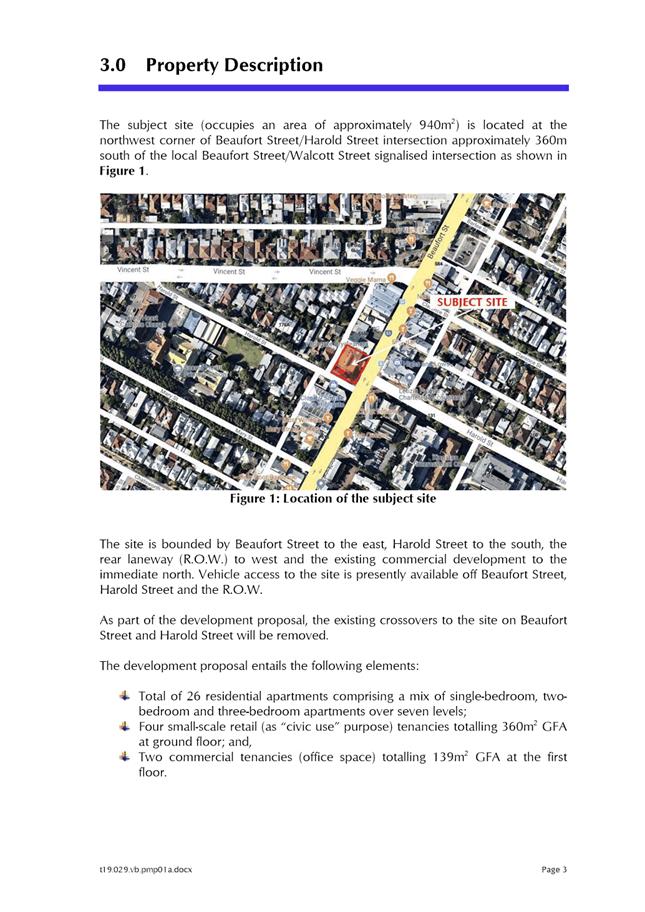
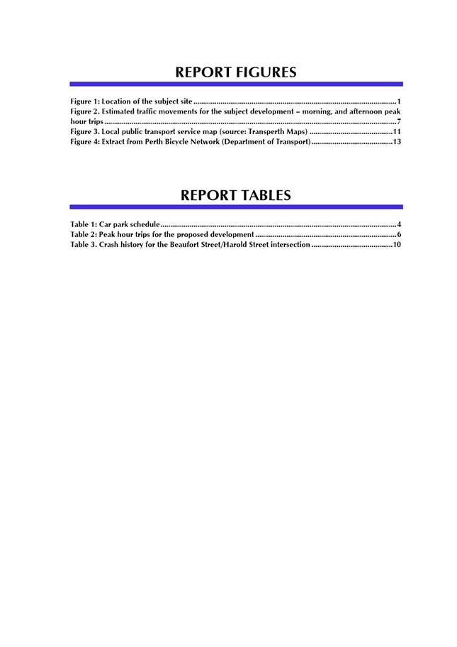
The subject site is located on the corner of Beaufort Street and Harold Street, and abuts an existing ROW to the north-west and an existing two-storey commercial building to the north-east. A location plan is included in Attachment 1. Beaufort Street is reserved as an Other Regional Road (ORR) under the Metropolitan Region Scheme (MRS) and is generally characterised by predominantly two-storey buildings. Opposite the subject site there is an existing four to five-storey building at Nos. 544 – 552 Beaufort Street and a three-storey building at No. 153 Harold Street.
The properties fronting Beaufort Street, including the subject site, are zoned Commercial under the City of Vincent Local Planning Scheme No. 2 (LPS2) and are within the Activity Corridor area under the City’s Policy No. 7.1.1 – Built Form (Built Form Policy). On the north-western side of the ROW there is existing residential development which is zoned Residential R50 under LPS2 and vary between single and three-storeys in height.
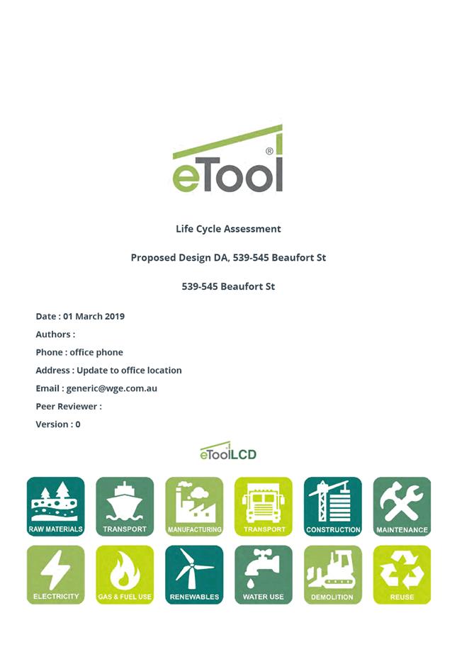
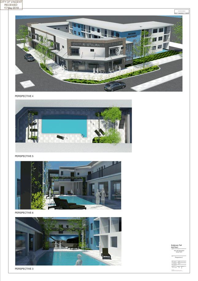
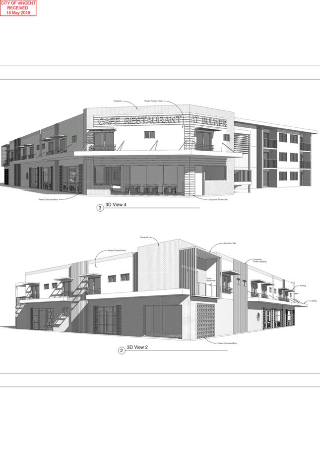
The development plans, including perspectives of the development, are included in Attachment 2. The supporting information provided by the applicant is included in Attachment 3 including a landscaping plan, acoustic report, traffic report and a lifecycle assessment.
Previous Applications
On 30 May 2017 the applicant submitted a development application for a four-storey mixed use development consisting of four Multiple Dwellings, nine short-term dwellings, four Shops and six Offices. This application was withdrawn on 30 November 2018 with no determination being made.
On 14 August 2017, the Western Australian Planning Commission (WAPC) granted conditional subdivision approval to realign the boundaries of the subject site and subdivide this into four lots (reference 155204). This approval is valid until 14 August 2020. The applicant has yet to seek to clear the conditions of this approval.
Details:
Summary Assessment
The proposal was assessed in accordance with the requirements of the Built Form Policy and Part 6 of State Planning Policy 3.1: Residential Design Codes (R Codes) which related to mixed use developments. Following the assessment of the application against the relevant deemed-to-comply standards, the Minster for Transport and Planning announced that State Planning Policy 7.3: Residential Design Codes Volume 2 – Apartments (R Codes Volume 2) would be gazetted on 24 May 2019 and supersede Part 6 of the R Codes. The proposal has been reassessed against the requirements of the R Codes Volume 2.
The R Codes Volume 2 provides guidance for the development mixed use development and focuses on improved design outcomes for apartments that are responsive and appropriate to the context and character of the site and locality. This is a performance-based assessment and applicants are required to demonstrate that the design achieves the objectives of each design element as well as the overall objectives of the R Codes Volume 2.
Consideration of Element Objectives and Acceptable Outcomes
The R Codes Volume 2 includes Element Objectives and Acceptable Outcomes for each design element. Proposals are required to demonstrate that the design achieves the Element Objectives for each design element. While addressing the Acceptable Outcomes is likely to achieve the relevant Element Objectives, they are not a deemed-to-comply pathway and the proposal is still to be assessed against the relevant Element Objectives. Where Acceptable Outcomes are not met, proposals may still satisfy the Element Objective via alternative means or solutions.
The Element Objectives and/or Acceptable Outcomes that are not achieved in the proposal are as follows:
|
Land Use |
|
|
Acceptable Outcome |
Proposal |
|
LPS2
‘P’ permitted use |
Multiple Dwellings are a ‘D’ discretionary use |
|
Building Height |
|
|
Acceptable Outcome |
Proposal |
|
Built Form Policy – Clause 2.1
C2.1.1 6 storey height
Concealed roof height of – 20.5m |
8 storey height
Concealed roof height of 25.9m to the top of the building and 26.4m to the top of the lift overrun |
|
Street Setbacks |
|
|
Acceptable Outcome |
Proposal |
|
R Codes Volume 2 – Clause 2.3
A2.3.1 2.0m setback to primary and secondary street above three storeys |
Fourth to sixth storeys have a nil setback to both the primary and secondary street |
|
Side and Rear Setbacks |
|||||||||||||
|
Acceptable Outcome |
Proposal |
||||||||||||
|
Built Form Policy – Clause 1.2.2
C1.2.3 Boundary setbacks for storeys above second storey – 4.0m |
Northern Setback Third storey – nil to 3.0m Fourth to eighth storey – 3.0m |
||||||||||||
|
Built Form Policy – Clause 1.2.5
C1.2.5 Ground floor, second and third storey setback – 6.5m
Fourth storey and above setback – 12.5m, measured form the midpoint of the ROW |
Western Setback Ground floor – 2.8m Second to third storey – 3.0m
Fourth storey – 3.0m Fifth storey – 5.1m Sixth storey – 6.0m Seventh storey – 6.9m Eighth storey – 9.6m |
||||||||||||
|
Plot Ratio |
|||||||||||||
|
Acceptable Outcome |
Proposal |
||||||||||||
|
R Codes Volume 2 – Clause 2.5
A2.5.1 Plot ratio - 2.0 |
Plot ratio – 3.0 |
||||||||||||
|
Building Depth |
|||||||||||||
|
Acceptable Outcome |
Proposal |
||||||||||||
|
R Codes Volume 2 – Clause 2.6
A2.6.1 Maximum building depth of 20.0m |
Building has a depth of 26.0m |
||||||||||||
|
Building Separation |
|||||||||||||
|
Acceptable Outcome |
Proposal |
||||||||||||
|
R Codes Volume 2 – Clause 2.7
A2.7.1 Ground to third storey setback – 6.5m
|
|
||||||||||||
|
Fourth storey setback – 12.5m, measured form the midpoint of the ROW
|
|
||||||||||||
|
Fifth to eighth storey – 9.0m to adjoining property boundary from habitable rooms and balconies |
|
||||||||||||
|
Tree Canopy and Deep Soil Areas |
|||||||||||||
|
Acceptable Outcome |
Proposal |
||||||||||||
|
R Codes Volume 2 – Clause 3.3
A3.3.4 10% of the site area provided as deep soil area, and two medium trees or one large tree and small trees to suit area
|
No deep soil provided. 58 medium sized trees provided |
||||||||||||
|
A3.3.7 Where the required deep soil areas cannot be provided 20% on-structure planting to be provided. |
18.5% of on-structure landscaping provided |
||||||||||||
|
Communal Open Space |
|
|
Element Objective |
Proposal |
|
R Codes Volume 2 – Clause 3.4
O3.4.1 Provision of quality communal open space that enhances resident amenity and provides opportunities for landscaping, tree retention and deep soil areas |
No communal open space areas are provided within the development |
|
O3.4.2 Communal open space is safe, universally accessible and provides a high level of amenity for residents |
|
|
O3.4.3 Communal open space is designed and oriented to minimise impacts on the habitable rooms and private open space within the site and of neighbouring properties |
|
|
O3.4.1 Provision of quality communal open space that enhances resident amenity and provides opportunities for landscaping, tree retention and deep soil areas |
|
|
Visual Privacy |
|
|
Acceptable Outcome |
Proposal |
|
R Codes Volume 2 – Clause 3.5
A3.5.1 Visual privacy setbacks to adjoining side and rear boundaries are provided in accordance with:
Ground to fourth storey: · 3.0m to bedroom/study; · 4.5m to other habitable room; and · 6.0m to outdoor spaces |
Northern Boundary Third storey – 3.0m to habitable – nil to balcony Fourth storey – 3.0m to habitable – 3.0m to balcony
|
|
Fifth to eighth storey: · 9.0m to bedroom/study; · 9.0m to other habitable room; and · 9.0m to outdoor spaces |
Western Boundary Third and fourth storey – 4.7m to balcony
Northern Boundary Fifth to seventh storey – 3.0m to bedroom – 3.0m to habitable – 3.0m to balcony Eighth storey – 4.5m to bedroom – 4.5m to habitable – 3.0m to balcony
Western Boundary Fifth storey – 6.6m to balcony Sixth storey – 7.7m to balcony Seventh storey – 8.6m to balcony |
|
Pedestrian Access and Entries |
|
|
Acceptable Outcome |
Proposal |
|
Built Form Policy – Clause 1.9
C .9.2 Access for pedestrians which directly fronts the primary street. |
Pedestrian entrance for apartments and office tenancies provided from Harold Street, the secondary street. |
|
Vehicle Access |
|
|
Acceptable Outcome |
Proposal |
|
A3.8.7 Walls, fences and other structures truncated or reduced to no higher than 0.75m within 1.5m of where walls, fences, other structures adjoin vehicle access points where a driveway meets a public street and where two streets intersect |
Adjoining property to the north located within sightline area to the north. |
|
Built Form Policy – Clause 1.10
C1.10.9 Each lot is to provide a maximum of 1 crossover |
2 crossovers provided for the access ramps from the ROW. |
|
C1.10.13 Crossovers must be setback a minimum of 0.5m from the lot boundary |
Crossover setback 0.2m from northern boundary |
|
Car and Bicycle Parking |
|
|
Acceptable Outcome |
Proposal |
|
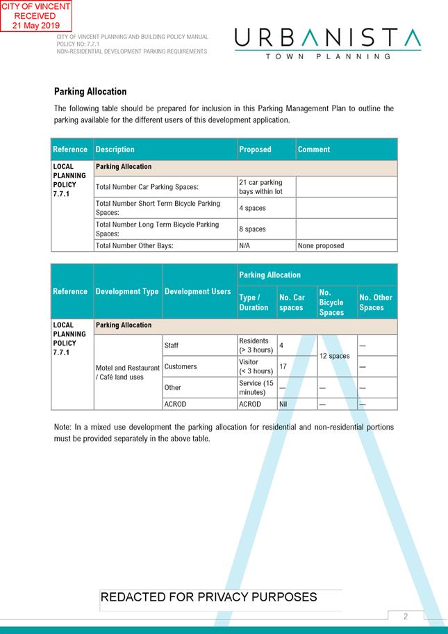
R Codes Volume 2 – Clause 3.9 and Policy No. 7.7.1 – Non-Residential Development Parking Requirements (Parking Policy)
Car Parking 4 visitor parking bays for apartments
16.5 parking bays for Shop use |
No visitor bays provided
4 bays provided |
|
Bicycle Parking
13 spaces for residents 2.6 spaces for visitors of apartments
9.1 spaces for Shop use 1.3 spaces for Office use |
9 spaces provided for residents and visitors
4 spaces provided for Shop use 1 space provided for Office use |
|
Solar Access and Daylight |
|
|
Acceptable Outcome |
Proposal |
|
R Codes Volume 2 – Clause 4.1
A4.1.1 (a) 70% of dwellings having living rooms and private open space obtain 2 hours of direct sun
A4.1.1 (b)15% receive no direct sunlight |
(a) 46% (12 of 26) of dwellings have living rooms and balconies receive at least 2 hours of direct sun (b) 54% (14 of 26) of dwellings receive no direct sun
|
|
A4.1.3 Light wells and/or skylights do not form the primary source of daylight to any habitable room |
Light well is primary source of daylight to Study in Apartments 2, 8, 14 and 19 |
|
Natural Ventilation |
|
|
Acceptable Outcome |
Proposal |
|
R Codes Volume 2 – Clause 4.2 A4.2.2 (b) Single aspect apartments must have: ventilation openings oriented towards the prevailing cooling wind direction
|
Apartments 2, 8 and 14, 19 do not having openings orientated towards the prevailing wind direction from the west |
|
A4.2.4 No habitable room relies on light wells as the primary source of fresh-air |
Light well is primary source of ventilation to Study in Apartments 2, 8, 14 and 19 |
|
Storage |
|
|
Acceptable Outcome |
Proposal |
|
R Codes Volume 2 – Clause 4.6
A4.6.1 Three bedroom apartments with a storeroom of – 5.0m² |
Three bedroom apartments provided with storerooms of 4.0m² |
|
Universal Design |
|
|
Acceptable Outcome |
Proposal |
|
R Codes Volume 2 – Clause 4.9
A4.9.1 (a) and (b) 20% of dwellings meet Silver Level and 5% of dwellings meet Platinum Level requirements of the Liveable Housing Design Guidelines |
Nil dwellings meet Silver of Platinum Level requirements as there is no disabled parking provided for the residents of the development and bathroom entrances and laundry spaces are less than 1.2m wide and handrails are not indicated on stairwell |
|
Landscape Design |
|
|
Acceptable Outcome |
Proposal |
|
R Codes Volume 2 – Clause 4.12
A4.12.3 Planting on building structures provided with 2.0m x 2.0m soil area for trees |
Tree planting soil areas are circular with 3.0m diameter |
|
Mixed Use |
|
|
Acceptable Outcome |
Proposal |
|
Built Form Policy – Clause 1.4
C1.4.13 Ground floor spaces with a width between 7.5m to 9m
|
‘Retail 1’ – 9.1 metres wide ‘Retail 2, 3 and 4’ – 6.7 metres wide |
|
N1.4.2 Floor to ceiling glazing |
Floor to ceiling glazing proposed for each of the retail tenancies |
|
Waste Management |
|
|
Acceptable Outcome |
Proposal |
|
R Codes Volume 2 – Clause 4.17
A4.17.1, A4.17.2 and A4.17.3 Waste storage facilities and waste management plan are provided in accordance with the City’s requirements |
No waste management plan provided with proposal |
|
Utilities and Facilities |
|
|
Element Objective |
Proposal |
|
R Codes Volume 2 – Clause 4.18
O4.18.4 Utilities within individual dwellings are of a functional size and layout |
Laundry areas in dwellings located in varying locations, including within bathrooms, entrance halls, regular hallways or own rooms and most do not appear to have sufficient space for necessary facilities. Drying locations unclear. Space available on balcony however this would not be screened |
|
Acceptable Outcome |
Proposal |
|
A4.18.4 Laundries are designed and located to be convenient to use, secure, weather-protected and well-vented; and are of an overall size and dimension that is appropriate to the size of the dwelling |
Laundries are internal and appropriate for each dwelling, however not provided with ventilation as they are typically located within a cupboard |
An assessment of how the proposal meets the Element Objectives of the R Codes Volume 2 – Apartments is discussed in the comments section below.
Consultation/Advertising:
Community Consultation was undertaken in accordance with the Planning and Development (Local Planning Schemes) Regulations 2015 for a period of 21 days from 8 February 2019 to 1 March 2019. The method of consultation being a sign on site, an advertisement in the local newspaper, and 604 letters mailed out to all landowners and occupiers surrounding the site (shown in Attachment 1) in accordance with the City’s Policy No. 4.1.5 – Community Consultation.
At the conclusion of the consultation period, a total of 25 submissions were received, comprising of four in support, 20 in objection, and one which expressed concerns but did not specifically support or object. The main issues raised in the submissions relate to the following matters:
· The height being out of character with the existing streetscape;
· The development impacting on the adjoining properties and the existing streetscape by way of building bulk due to the increased height and plot ratio and reduced setbacks;
· The suitability of the proposed landscaping, including ongoing maintenance; and
· The adequacy of the parking provided for the development, including for residents, visitors and the commercial tenancies, and the impact on existing on-street parking as a result.
A summary of the submission received and Administration’s comments with respect to these is provided in Attachment 4. The applicant has also provided a response to these submissions which is included in Attachment 5.
Department of Planning, Lands and Heritage
The application was referred to the Department of Planning, Lands and Heritage (DPLH) as the development abuts Beaufort Street which is reserved as an Other Regional Road (ORR) under the Metropolitan Region Scheme. The DPLH advised that it had no objection to the proposal subject to all relevant subdivision conditions be implemented as part of the proposed development. Should the application be approved, it is recommended that these conditions be included.
The DPLH also provide some additional considerations to be taken into account. These include:
· The rear ROW being configured to facilitate two-way access;
· Due regard to be given to State Planning Policy 5.4 – Road and Rail Transport Noise and Freight Considerations in Land Use Planning (SPP 5.4); and
· Consideration be given to the performance of the Harold Street and Beaufort Street intersection post-development, to the satisfaction of the City.
These considerations are discussed further in the comment section.
Design Review Panel (DRP):
Referred to DRP: Yes
The application was referred to the DRP on 16 January 2019 and 20 March 2019. The minutes from the most recent meeting and applicant’s response to these comments is included in Attachment 6
Legal/Policy:
· Planning and Development Act 2005;
· Planning and Development (Local Planning Schemes) Regulations 2015;
· City of Vincent Local Planning Scheme No. 2;
· State Planning Policy 3.1 – Residential Design Codes;
· State Planning Policy 5.4 – Road and Rail Transport Noise and Freight Considerations in Land Use Planning;
· State Planning Policy 7.3 – Residential Design Codes Volume 2 – Apartments;
· Policy No. 4.1.5 – Community Consultation;
· Policy No. 7.1.1 – Built Form Policy;
· Policy No. 7.5.21 – Sound Attenuation;
· Policy No. 7.5.23 – Construction Management Plans; and
· Policy No. 7.7.1 – Non-Residential Development Parking Requirements
Planning and Development Act 2005
Should Council refuse the application for development approval, the applicant may have the right to have the decision reviewed in accordance with Part 14 of the Planning and Development Act 2005.
State Planning Policy 7.3 Residential Design Codes – Volume 2 Apartments
The R Codes Volume 2 provides comprehensive guidance for the development of multiple dwellings and mixed use development and focuses on improved design outcomes for apartments that are responsive and appropriate to the context and character of the site and locality. This is a performance based assessment and applicants are required to demonstrate that the design achieves the objectives of each design element as well as the overall objectives of the R Codes Volume 2.
Delegation to Determine Applications:
This matter has been referred to Council in accordance with the City’s Delegated Authority Register as the proposed development incorporates more than three dwellings that are three storeys in height and has received more than five objections.
RiSk Management Implications:
There are minimal risks to Council and the City’s business function when Council exercises its discretionary power to determine a planning application.
Strategic Implications:
This is in keeping with the City’s Strategic Community Plan 2018-2028:
Innovative and Accountable
We are open and accountable to an engaged community.
SUSTAINABILITY IMPLICATIONS:
Nil.
Financial/Budget Implications:
Nil.
Comments:
Land Use
Multiple Dwellings are a discretionary ‘D’ use within the Commercial zone. The land use is consistent with the objectives of the Commercial zone under LPS2 for the following reasons:
· The apartments are located within a mixed use development which incorporates compatible commercial uses being Shop and Office on the ground and second storey. The development would result in an increase in residents in the locality who can support the local economy along Beaufort Street and surrounding areas;
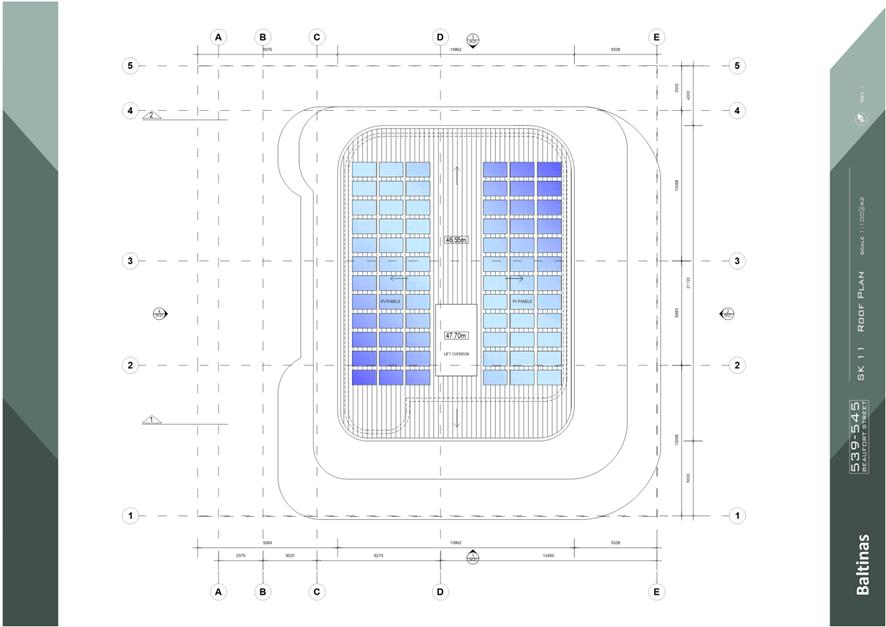
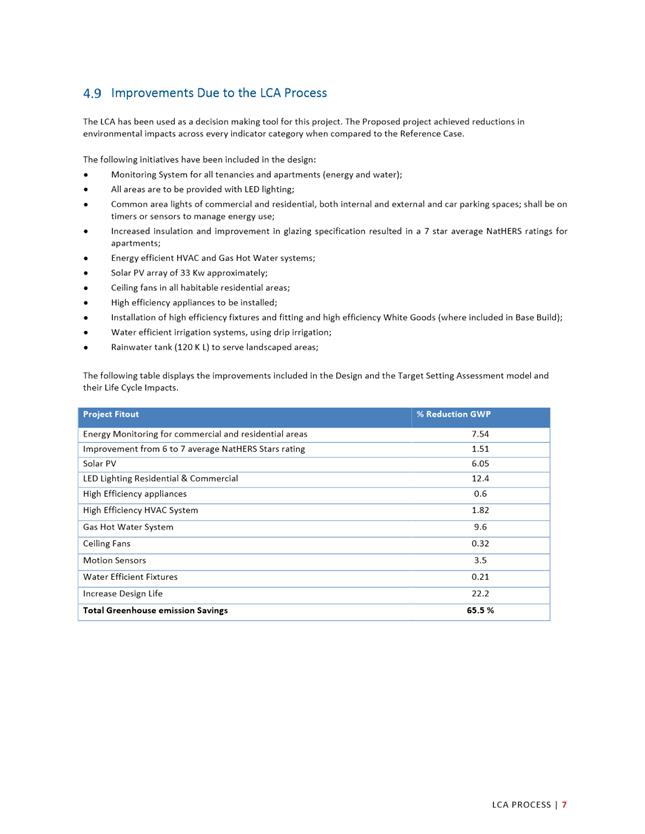
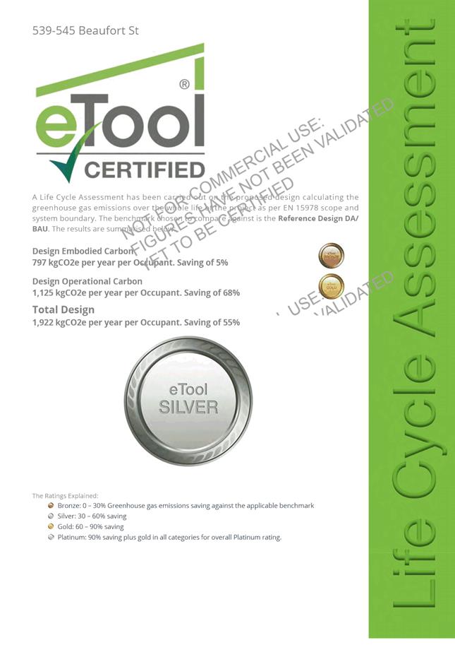
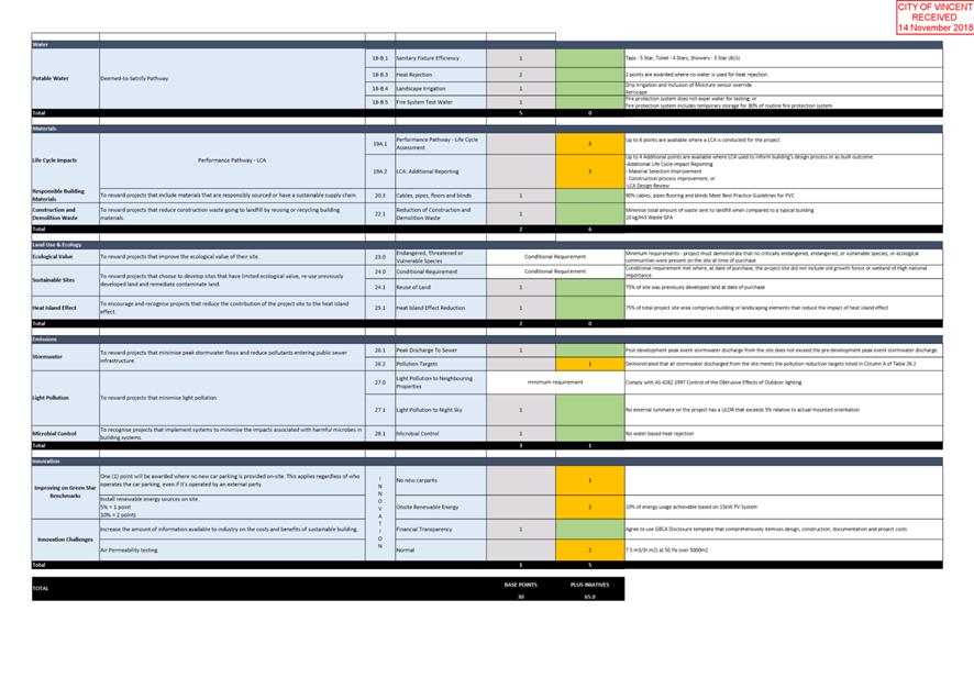
· The development contributes towards sustainability principles as demonstrated by the life cycle assessment provided by the applicant. This includes the inclusion of solar PV panels, use of rainwater to service landscaping area, and the use of high efficiency fixtures and systems. Overall the development is projected to have a greenhouse gas emission saving of 65.5 percent; and
· As discussed further in this report, the development is compatible with the existing streetscape and amenity locality, having regard to the Commercial zoning and Activity Corridor context of the subject site.
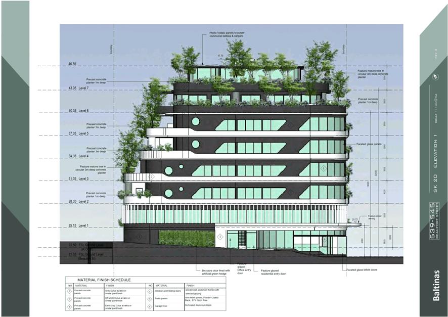
Building Height
The proposed building height is consistent with the objectives of Element 2.2 of the R Codes Volume 2 – Apartments and the local housing objectives of the Built Form Policy for the following reasons:
· The upper floors are stepped in from the side and rear boundaries, with the seventh and eighth storeys setback so that they are not visible from Beaufort and Harold Street. When viewed from the street the height is six storeys, which is consistent with the six-storey deemed-to-comply standard within the Built Form Policy for the area;
· The subject site slopes approximately 2.30 metres from the south-western corner to the north-eastern corner. The building height responds to this with the height focused towards the street frontages and separation provided from the adjoining residential property to the west;
· The building design allows for articulation with balconies and landscaping provided for each apartment. The development does not restrict access to daylight or result in overshadowing for the residential development located to the west of the subject site. The building height provides for celling heights of 3.0 metres to 3.2 metres, allowing for future adaptability of the commercial tenancies and increased amenity for the residential apartments.
Street Setbacks
The proposed setback to Beaufort Street and Harold Street is consistent with the objective of Element 2.3 of the R Codes Volume 2 – Apartments for the following reasons:
· The development provides a focal point at the intersection of Beaufort Street and Harold Street, with building massing and scale focussed on the corner. The upper floor facades are provided with articulation through the use of glazing, major openings and balconies. A variety of colours and textures are included on the façade, and landscaping is incorporated around the perimeter of the building. The seventh and eighth storeys are setback so they are not visible from the street level. Notwithstanding the current built form of the area, the street setbacks provide a strong urban edge to the development and is in keeping with the expectations of the Activity Corridor context it is located within; and
· The development provides for a clear transition between the public and private realm, whilst providing passive surveillance of the streets. This is achieved through the positioning of balconies and major openings to habitable rooms. Given the balconies situated above the street level, sufficient visual privacy for the residents of the apartments is provided.
Side and Rear Setbacks, Building Separation and Visual Privacy
The proposed setbacks to the side and rear boundaries are consistent with the objectives of Elements 2.4, 2.6 and 3.5 for the following reasons:
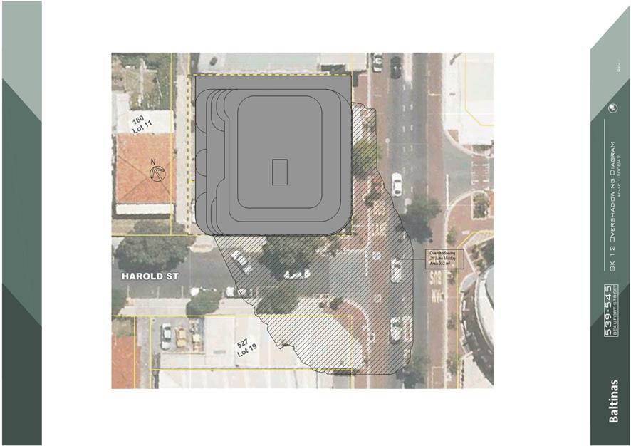
· Adequate separation is provided to the properties to the north and west of the subject site to provide for access to natural sun and ventilation. Given the orientation of the subject site there is no overshadowing on the adjacent residential properties, with this falling on the road and commercial property to the south;
· The development has been designed so that the setbacks to the west increases the building separation as the height of the building does. This assists with reducing the perception of building bulk and scale on the adjacent resident properties to the west. Although the existing built form along Beaufort Street is currently low scale, the setbacks contribute towards providing a strong urban edge for the development and are consistent with the Activity Corridor context of the subject site;
· Visual privacy to the adjacent dwellings to the west is maintained through inclusion of mature landscape screening around the balconies to prevent direct overlooking into outdoor living areas. Remaining overlooking would fall onto roofed areas. To the north, there is no visual privacy concerns given this is currently a commercial property and overlooking would fall onto the roof of the adjoining building;
· The setbacks provide for landscaping opportunities to be incorporated into the design, including mature trees to contribute towards canopy coverage and increased amenity. The landscaping provided assists with mitigating the perception of building bulk from the street and surrounding properties;
· The setbacks provide for sufficient residential amenity for future occupants of the apartments. Balconies are designed with outlook provided to the public realm, and to ensure visual and acoustic privacy is maintained. Each apartment has been designed to provide for adequate natural ventilation, sunlight and daylight access, while also providing passive surveillance to the streetscape; and
· Although the development does not provide for communal open space or deep soil areas, each dwelling is provided with sufficient balcony sizes with appropriate orientation and on-structure landscaping is included around the building edge between adjoining sites.
Plot Ratio
The proposed plot ratio is consistent with the objectives of Element 2.5 of the R Codes Volume 2 – Apartments for the following reasons:
· The development incorporates design measures so as to mitigate building bulk impacts, including the setting back of the upper floors, the provision of articulated facades through the use of major openings and balconies, varying textures and colours and the incorporation of landscaping around the perimeter of the building;
· As discussed in greater detail below, the development provides for sufficient car parking, as well as catering for a variety of dwelling types and land uses. The scale of the development is therefore appropriate; and
· In considering the bulk and scale, the development is consistent with the future desired built form of the locality as envisaged by the Activity Corridor Form Area of the Built Form Policy. While the development represents a departure from the current built form of the locality, the current built form is somewhat inconsistent given it includes medium density residential and low-scale commercial uses, and as per the discussion above the design is suitable to mitigate any impacts as a result. Notwithstanding the current built form, the proposal is consistent with the future redevelopment of the area, and the promotion of higher density development within close proximity to the Perth CBD and other high amenity areas, and is well serviced by public transport.
Building Depth, Solar Access and Daylight and Natural Ventilation
The proposed building depth is consistent with the objectives of Elements 2.6, 4.1 and 4.2 of the R Codes Volume 2 – Apartments for the following reasons:
· The development has sought to optimise the number of dwellings which receive winter sun given the constrained nature of the subject site requiring the need to address both the Beaufort Street and Harold Street frontages;
· Each habitable room is provided with large windows to optimise daylight access. This is aided by the orientation of the apartments, which are generally shallow to maximise access to direct sun and allow for passive heating. High ceilings have also been provided to increase access to direct sun which is also assisted by not having balconies overhanging the major openings located underneath. Screen louvres are provided to each window to provide shading, which will also be assisted by the growth of the on-structure planting over time;
· The development maximises the number of apartments with natural ventilation by locating the majority of apartments on the corner of the building to assist in providing openings to two different directions. The orientation of apartment minimises the depths of each so as to assist in capturing the breeze throughout each dwelling and maintain effective airflow;
· Single aspect apartments have been designed to open onto balconies and with external openings to each window to provide natural airflow through connected internal doorways.
Tree Canopy and Deep Soils and Landscape Design
The proposed landscaping is consistent with the objectives of Elements 3.3 and 4.12 of the R Codes Volume 2 – Apartments for the following reasons:
· The proposal has incorporated landscaping and tree planting along the edge of the balconies for each apartment, to provide amenity for occupants and also assist to with softening the built form when viewed from the public realm, as an alternative means to providing deep soil areas;
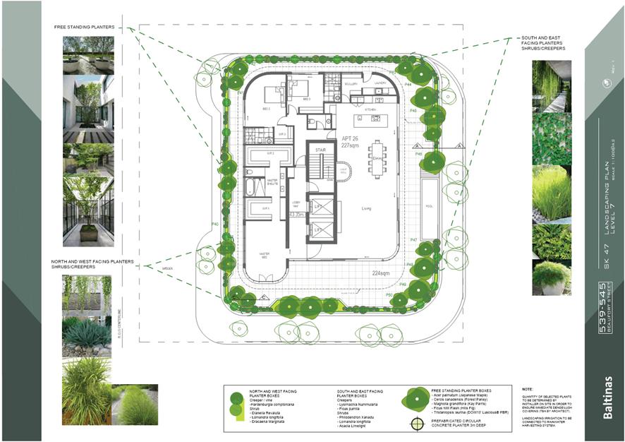
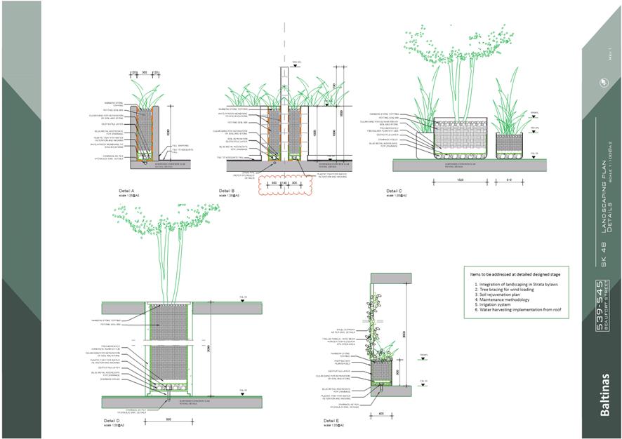
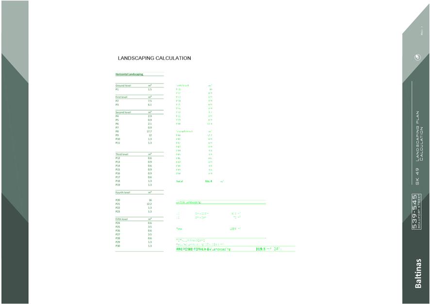
· The on-structure planting includes the provision of prefabricated concrete planters with a depth of 3.0 metres to support the provision of medium mature trees. These have been placed around the development to allow for the trees to grow up through the floor of the balcony, providing canopy coverage to each storey and ensuring that this is not inhibited by the building structure. These trees are visible from the public domain. In addition, the on-structure planting incorporates shrubs and creepers, to provide additional amenity to both occupants and the public domain;
· The applicant has engaged a landscape architect with regards to the design and specification of landscaping, and has advised that the implementation of the proposed landscaping has been considered through the initial design phase;
· The landscaping includes provision for irrigation to assist with maintenance, with the applicant also advising that water harvesting and the integration of landscaping maintenance into strata by-laws will be implemented to ensure its long-term viability; and
· The development results in a substantial improvement to the number of trees and associated tree canopy that currently exists on the subject site.
Communal Open Space
The proposal is not consistent with the objectives of Element 3.4 of the R Codes Volume 2 – Apartments. Although the development does not provide for any communal open space within the building, it is consistent with the overall objectives of the R Codes Volume 2 – Apartments for the following reasons:
· Each apartment is provided with a large balcony area, which provides residents the opportunity to recreate and have social interaction. The balcony areas are capable of being used in conjunction with the adjoining living rooms to provide additional space for social gatherings, and include significant landscaping incorporating tree canopy coverage, around the perimeter to increase amenity; and
· The subject site is well located with access to public spaces which provides opportunities for social interaction and recreation. The subject is located within approximately 350 metres of Hyde Park to the west and 300 metres to Forrest Park to the east. In addition, there are a number of public and private spaces located in the Mount Lawley/Highgate Activity Centre along Beaufort Street, which provides additional opportunities for social interaction for residents. Given the location it is not uncommon for developments of this size to not include communal areas within the building.
Pedestrian Access and Entries
The proposed pedestrian entrances from the secondary street, being Harold Street, is consistent with the objectives of Element 3.7 of the R Codes Volume 2 – Apartments and the local housing objectives of the Built Form Policy for the following reasons:
· Entrances to the ground floor retail tenancies are provided from Beaufort Street, while the entrance to the office tenancies on the second storey and the residential apartments above are provided from Harold Street. All entrances are clearly defined and legible, and coordinated with the adjoining footpath level to provide universal access; and
· The development is oriented towards the street frontages with the primary pedestrian access provided from the public domain to increase activation along these frontages. The development incorporates a pedestrian awning around the ground floor to provide weather protection to pedestrians and protecting the entrances along Beaufort Street and Harold Street. The location of these entrances is not impacted by service areas or external fixtures.
Vehicle Access
The proposed vehicle access arrangements are consistent with the objectives of Element 3.8 of the R Codes Volume 2 – Apartments and local housing objectives of the Built Form Policy for the following reasons:
· Vehicle access is provided from the ROW and is not visible from the street frontage. Roller shutters are proposed to screen the visual impact from the ramps, parking bays and storerooms on the ground floor from the ROW; and
· Vehicle access has been designed for vehicles in the basement and second storey to enter in forward gear. The tandem bays on the ground floor are not accessible in forward gear, however noting the low speed environment of the ROW, this is acceptable. As part of the application and concurrent subdivision, the ROW is proposed to be widened to facilitate safer vehicle access for the subject site and surrounding properties which use this as their primary access. Should the application be approved, a condition to this effect is recommended. The vehicle access provides adequate visibility to ensure the safety of vehicles, cyclists and pedestrians, noting the low-speed environment of the ROW. The vehicle access is located 9.1 metres from the intersection with Harold Street to provide a safe distance.
Car Parking
The development proposes a total of 60 parking bays, located between the basement, ground floor and second storey. Within the basement, parking is proposed within car stackers, while on the ground floor, tandem parking is provided directly accessible from the ROW. Under the Acceptable Outcomes of the R Codes Volume 2 – Apartments and Parking Policy, the parking required for the development is:
· 25 residents parking bays and four visitor bays;
· 16.5 bays of the Shop use; and
· 2.9 bays for the Office use.
The applicant has provided a Parking Management Plan (PMP) which is included in Attachment 3 has allocated the 60 on-site parking bays as follows:
· 52 bays for residents and no bays for visitors. Of the 52 bays, the applicant has advised that 11 of these would be made available for visitors of the larger apartments, while other visitors would use on and off-street parking in the area;
· Four bays for the Shop use; and
· Four bays for the Office use.
The parking on-site is appropriate for the development for the following reasons:
· With respect to the residential parking, there is a surplus of resident’s bays and the applicant’s PMP identifies that 11 bays are to be provided for some visitors, but not all. There is sufficient capacity within the proposal for a minimum number of bays to be dedicated for all visitors to the apartments. Given 11 bays are identified to be made available to visitors of the larger apartments, four bays should be dedicated for visitors, consistent with the Acceptable Outcome figure. Should the application be approved, a condition of approval is recommended for a minimum of four parking bays to be dedicated as visitor parking bays, and 41 bays to be dedicated to residents. This would give the applicant the ability to provide the seven remaining bays for visitors of the larger apartments, or for this to be provided as additional residents parking bays;
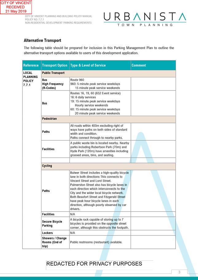
· With respect to the non-residential parking, the Office use satisfies the parking requirement under the Parking Policy, however the Shop has a 12.5 bay shortfall. Four bays are dedicated for the staff of each use, with the applicant proposing that customers and any additional staff would utilise public transport and alternative transport methods, as well as public parking (on and off-street) within vicinity of the subject site. Given the location of the subject site, this is acceptable, with the following available:
o The subject site is well serviced by public transport, with dedicated morning and afternoon bus lanes provided on either side of Beaufort Street, and bus stops within approximately 25 and 80 metres of the subject site;
o 20 bicycle parking spaces are provided. Although the development requires 26 in accordance with the R Codes Volume 2 – Apartments and the City’s Parking Policy, Administration recommends that a condition be imposed requiring the provision of 26 bicycle facilities. Given the location of the subject site and the nature of the development it is appropriate that these spaces be provided, which can be used by staff and customers to access the various uses. The bike spaces are currently not easily accessible for customers and visitors, so it is recommended that a condition be imposed for eight of these spaces to be relocated as such. End of trip facilities are provided within the non-residential tenancies for use by staff. The provision of these spaces will facilitate and encourage alternative modes of transport to and from the development, consistent with the City’s Parking Policy;
o Pedestrian access is provided via footpaths along Beaufort Street and Harold Street, with pedestrian crossings provided to assist pedestrians with crossing over Beaufort Street; and
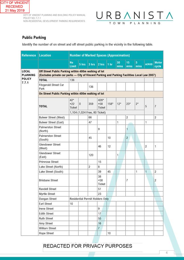
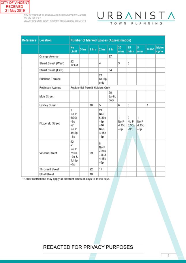
o There are 42 on-street bays available along Harold Street (between Beaufort Street and Stirling Street), and 123 on-street bays along Beaufort Street (one and two hour parking between Newcastle Street and Walcott Street). The City’s transport data indicates that on average, 19 bays are available along Harold Street and 51 bays available along Beaufort Street over the course of the day. It is acknowledged that the parking along Beaufort Street is for a distance of approximately 1.8 kilometres. In addition there is 56 parking bays located within the public car park at Nos. 590-596 Beaufort Street, approximately 130 metres from the subject site. The City’s data indicate that on average there is 17 bays available during the course of the day. In light of this there is sufficient parking to accommodate for customers of the non-residential tenancies.
Storage
The proposal satisfies the objectives of Element 4.6 of the R Codes Volume 2 – Apartments as a storage area with a function dimension and size, being 1.5 metres and 4.0 metres respectively, for each apartment. The storage areas are located throughout the building with some positioned adjacent to the balconies of dwellings to provide convenient access, but also integrated with the building design so as to not be visually obtrusive to the public realm. The remaining storage areas are located next to parking areas to provide easy access from vehicles, and in close proximity to the stairwell and lift to ensure easy access by residents.
Universal Design
The proposal satisfies the objectives of Element 4.9 of the R Codes Volume 2 – Apartments as the building has been designed to provide universal access and the dwelling sizes provide accommodation options of people with disabilities and to accommodate ageing in place. Through the planning framework there is no requirement for disabled car parking to be provided, however it is noted the Building Codes of Australia require these spaces to be provided, which the applicant will need to demonstrate through the building permit process should the application be approved. As noted previously there is a surplus of car parking on the site for this accessible parking to be provided without impacting on the allocation of bays. It is noted that the internal layout of the apartments may be refined during the detailed design stage should the application be approved, to improve accessibility of people with disabilities.
Mixed Use
The proposal satisfies the objectives of Element 4.14 of the R Codes Volume 2 – Apartments and the local housing objectives of the Built Form Policy for the following reasons:
· The development has been designed to enhance and activate the street. Entrances to the retail tenancies are provided directly from Beaufort Street and entrances to the office tenancies and apartments provided from Harold Street. The entrances between the different uses are clearly distinguishable and separate from each other, and have been positioned to protect amenity. A pedestrian awning is provided around both street frontages to provide weather protection. Glazing and articulation is provided on the retail tenancies to facilitate interaction and major openings and balconies are provide to the apartments on the upper floors to provide for street surveillance;
· The acoustic report provided by the applicant confirms that the apartments will not be negatively impacted by noise from the non-residential uses within the development;
· Waste for the development is stored in one area which is located on the ground floor to protect the amenity of residents. The storage area is enclosed so that the amenity of the retail tenancies and pedestrian entry is also maintained; and
· Appropriate parking is provided on the site for the various uses, as discussed above. This ensures that residents parking will not be used by staff or customers of the non-residential uses.
Waste Management
The proposal is consistent with the objectives of Element 4.17 of the R Codes Volume 2 – Apartments as the waste storage area is located within building on the ground floor, separate from pedestrian entry and tenancies and not visible from street to ensure that there is no impact on the amenity of the residents or public realm. The waste storage area is conveniently accessed by residents and bins can be directly collected from Harold Street. Through reviewing the proposal, the City’s Waste Services have identified that further information is required to determine the amount of waste generated from the different uses of the building and the size bins that would be necessary to meet these needs. Should the application be approved a condition is recommended for a Waste Management Plan to be prepared by the applicant and approved by the City, ensuring that adequate waste management measures are implemented.
Utilities and Facilities
The proposal is not consistent with the objectives of Element 4.18 of the R Codes Volume 2 – Apartments. Although the development does provide for the necessary infrastructure services and utilities for the building are conveniently located and integrated within the building façade, individual utilities for the apartments are not adequately designed. The laundry areas within individual apartments are located in varying locations, including within bathrooms, apartment entrances and hallways, as well as within a laundry room in some instances. The areas typically don’t appear to have sufficient space for necessary laundry facilities such as the washing machine, tub and storage space, and are not well ventilated. There is space available for clothes drying areas on each balcony, however these would not be screened from view from the public realm and adjoining properties.
While this is not consistent the Element Objectives, the proposal is consistent with the overall objectives of the R Codes Volume 2 – Apartments as the apartments provide a high level of amenity for residents. Although the laundry facilities provided do not appear to be sufficient, it is noted that the internal layout of the apartments may be refined during the detailed design stage should the application be approved, to improve this aspect. It is also noted that other alternative solutions could be considered to improve the useability of these spaces during this process.
DPLH Comments
In addition to the DPLH’s recommended conditions, it also provided some additional considerations to be taken into account by the City in its assessment of the application. These include:
· The rear ROW being configured to facilitate two-way access;
· Due regard to be given to SPP 5.4; and
· Consideration be given to the performance of the Harold Street and Beaufort Street intersection post-development, to the satisfaction of the City.
In response to these the following is noted:
· The existing ROW is 3.2 metres wide. The subdivision approval includes a requirement for the ROW adjoining the subject site to be widened by 1.4 metres, resulting in a width of 4.6 metres. The WAPC’s Planning Bulletin 33 – Rights of Way or Laneways in Established Areas identifies that a long term view to widening of existing ROW’s is to be taken, by requiring widening to be provided at the time of redevelopment to achieve an ultimate width of 6.0 metres. Should the application be approved, it is recommended that a conditioned by imposed for this 1.4 metre widening to be provided, and over time as redevelopment of properties adjoining the ROW occurs, the ROW will be widened to ultimately facilitate two-way access with a width of 6.0 metres;
· Due regard has been given to SPP 5.4 as an acoustic report has been provided to assess the impact of transport noise on the development. The acoustic report recommends that a further report be undertaken as part of the detailed design phase to identify measures to be implemented into the façade design including glazing requirements. This is recommended to be included as a condition should the application be approved. The subdivision approval also imposed a condition for a notification to be included on titles advising of the location within a transport corridor and the potential to be affected by transport noise. Should the application be approved, it is recommend that this condition be imposed; and
· The WAPC’s Transport Assessment Guidelines identify that a SIDRA analysis is required when the traffic flow generated by the development increase the traffic on any lane by 100 vehicles per hour and increases the traffic flow in the intersection by 10 percent. The applicant has submitted a traffic report which identifies that the development would generate 278 daily vehicle trips with 21 and 24 trips during the AM and PM peak hours respectively and is considered to have a moderate impact. As a result this development does not trigger the requirements for a SIDRA analysis to be undertaken. Having reviewed the traffic report the City is satisfied that the traffic generated by the development can be accommodated in the network.
5.3 No. 160-166 (Lot No's. 32, 33, 34, 201 and 202) Palmerston Street, Perth - Change of Use to Motel and Addition of 11 Motel Rooms and Restaurant/Cafe
TRIM Ref: D19/73159
Author: Mitchell Hoad, Senior Urban Planner
Authoriser: Jay Naidoo, Manager Development & Design
Ward: South
Attachments: 1. Consultation
and Location Map ⇩ ![]()
2. Development Plans
⇩ ![]()
3. Written
Justification and Supporting Technical Reports ⇩ ![]()
4. Administration's
Response to Summary of Submissions ⇩ ![]()
5. Applicant's
Response to Summary of Submissions ⇩ ![]()
6. Design Review
Panel Minutes ⇩ ![]()
7. Determination
Advice Notes ⇩ ![]()
|
That Council, in accordance with the provisions of the City of Vincent Local Planning Scheme No. 2 and the Metropolitan Region Scheme, APPROVES the application for a Change of Use to Motel and Addition of 11 Motel Rooms and Restaurant/Cafe at No. 160-166 (Lot: 32, 33, 34, 201 and 202; D/P: 690, 302209 and 39093) Palmerston Street, Perth, in accordance with the plans shown in Attachment 2 and the determination advice notes at Attachment 7: 1. Use of Premises 1.1 This approval relates to a Change of Use to Motel and Restaurant/Cafe as shown on the plans dated 6 May 2019 and 15 May 2019. It does not relate to any other development on the site; 1.2 The use of the Motel and Restaurant shall only be used in accordance with the definition in the City of Vincent’s Local Planning Scheme No. 2 as follows: Motel means premises, which may be licensed under the Liquor Control Act 1988 – (a) used to accommodate guests in a manner similar to a hotel; and (b) with specific provision for the accommodation of guests with motor vehicles; Restaurant/Café means premises primarily used for the preparation, sale and serving of food and drinks for consumption on the premises by customers for whom seating is provided, including premises that are licensed under the Liquor Control Act 1988. 1.3 A maximum of 56 patrons shall be permitted within the Restaurant/Café at any one time; 2. Parking and Access 2.1 A minimum of 21 off-street parking bays shall be provided. The parking bays are not to be used for storage purposes or the like. Of these bays: · 4 shall be provided for staff of the Motel and Restaurant/Café use; and · 17 for the guests of the Motel and customers of the Restaurant/Café.
2.2 The car parking and access areas shall be sealed, drained, paved and line marked in accordance with the approved plans and are to comply with the requirements of AS2890.1 prior to the occupation or use of the development. 2.3 A minimum of 12 bicycle facilities shall be provided and designed in accordance with AS2890.3 prior to the occupation of the premises. 3. Acoustic Report 3.1 A revised Acoustic Report shall be lodged with and approved by the City, in accordance with the City’s Policy No. 7.5.21 – Sound Attenuation prior to the commencement of the development. This revised Acoustic Report shall address, but is not limited to, the following: · The emission of noise from the Restaurant/Café, including music, commercial kitchen exhausts and air conditioner and other servicing units; and
3.2 All of the recommended measures included in approved Acoustic Report referred to in 3.1 shall be implemented prior to the occupation or use of the development and maintained thereafter to the satisfaction of the City at the expense of the owners/occupiers; 4. Parking Management Plan 4.1 Prior to occupation of the development, a revised Parking Management Plan shall be submitted to and approved by the City. The revised Parking Management Plan is to include, but not limited to, the following: · Details regarding the reciprocal use of the 17 bays allocated to Motel guest and Restaurant/Café customer parking; and · Detailed management measures to ensure that access to these bays is readily available at all times and that guests of the Motel are made aware of the availability of on-site parking at the time of booking; and
4.2 The Parking Management Plan as identified in Condition 4.1 shall be implemented and the development carried out in accordance with the approved Parking Management Plan and approved plans to the satisfaction of the City. 5. Landscaping Plan 5.1 A detailed landscape and reticulation plan for the development site and adjoining road verge, to the satisfaction of the City, shall be lodged with and approved by the City prior to commencement of the development. The plan shall be drawn to a scale of 1:100 and show the following: · The location and type of existing and proposed trees and plants; · Areas to be irrigated or reticulated; · The provision of 8.7 percent of the site area as deep soil zones; and · The appropriate selection of tree species (consistent with the City’s Tree Selection Tool) to be located within the deep soil areas to maximise the provision of canopy coverage; and
5.2 All works shown in the plans identified in Condition 5.1 above shall be undertaken in accordance with the approved plans to the City’s satisfaction, prior to occupancy or use of the development and maintained thereafter to the satisfaction of the City at the expense of the owners/occupiers; 6. Verge Infrastructure No verge tree shall be removed without the prior written approval of the City. The verge tree shall be retained and protected from damage including unauthorised pruning to the satisfaction of the City;
7. Building Design 7.1 Windows and doors of the ground floor tenancies fronting Bulwer, Palmerston and Earl Streets shall provide an active and interactive relationship to the street to the satisfaction of the City and shall be maintained thereafter to the satisfaction of the City; 7.2 Ground floor glazing and/or tinting shall be a minimum of 70 percent visually permeable to provide unobscured visibility. Darkened, obscured, mirrored or tinted glass or other similar materials as considered by the City is prohibited; 7.3 All external fixtures and building plant, including air conditioning units, piping, ducting and water tanks, shall be located so as to minimise any visual and noise impact on surrounding landowners, and screened from view from the street, and surrounding properties to the satisfaction of the City; and 7.4 The awning within the Palmerston Street and Bulwer Street road reservation, attached to the façade of the building shall be designed to be removable, to the satisfaction of the City. This is to be demonstrated as part of the building permit; 8. Amalgamation Prior to the occupation of the development, the subject land shall be amalgamated into one lot on the Certificate of Title; 9. Construction Management Plan A Construction Management Plan that details how the construction of the development will be managed to minimise the impact on the surrounding area shall be lodged with and approved by the City prior to the commencement of the development. The Construction Management Plan is required to address the following concerns that relate to any works to take place on the site: · Public safety, amenity and site security; · Contact details of essential site personnel; · Construction operating hours; · Noise control and vibration management; · Dilapidation Reports of nearby properties; · Air, sand and dust management; · Stormwater and sediment control; · Soil excavation method; · Waste management and materials re-use; · Traffic and access management; · Parking arrangements for contractors and subcontractors; and · Consultation plan with nearby properties;
10. Waste Management 10.1 A Waste Management Plan prepared to the satisfaction of the City shall be submitted approved by the City prior to the commencement of the use; and 10.2 Waste management for the development shall thereafter comply with the approved Waste Management Plan; and 11. Schedule of External Finishes Prior to the commencement of development, a detailed schedule of external finishes (including materials, colour schemes and details) shall be submitted to and approved by the City. The development shall be finished in accordance with the approved schedule prior to the use or occupation of the development. |
Purpose of Report:
To consider an application for development approval for a Change of Use to a Motel for the existing building, and a new two-storey building as a Restaurant/Café on the ground floor and a Motel on the second storey at No. 160-166 Palmerston Street, Perth (subject site).
PROPOSAL:
The application proposes to change the use of the existing Batavia Apartments on the subject site from Residential Flats to Motel, and the construction of a new two-storey building to accommodate a Restaurant/Café on the ground floor and 11 additional Motel rooms on the second storey. The additional rooms would continue to be operated by the existing operator of the Batavia Apartments.
The Restaurant/Café is proposed to accommodate 56 patrons. The ground floor also includes a reception area for the Motel and office and laundry facility for us by staff and guests respectively. The second storey is proposed to accommodate 11 new rooms for the Motel, taking the total number of rooms on the subject site to 32.
There are no specified hours of operation for the Restaurant/Café, although the applicant has provided indicative hours of 11am to 2pm and 5pm to 10pm Monday to Sunday, subject to the future operator requirements should the proposal be approved. The Motel reception hours of operation are from 9:00am to 5:00pm Monday to Sunday. Out of these hours, check-in and check-out would be undertaken by staff of the Restaurant/Café or any other available staff. Staff for the development is proposed to consist of:
· Two cleaners/maintenance staff;
· One receptionist;
· One kitchenhand; and
· Three restaurant staff.
The development does not propose any works to the existing building or increase to the 22 parking bays currently on the site.
Background:
|
Landowner: |
Starlily Nominees Pty Ltd |
|
Applicant: |
Toh Construction Pty Ltd |
|
Date of Application: |
31 January 2019 |
|
Zoning: |
MRS: Urban / Other Regional Road LPS2: Zone: Mixed Use R Code: R40 |
|
Built Form Area: |
Residential |
|
Existing Land Use: |
Residential Flats |
|
Proposed Use Class: |
Motel and Restaurant/Cafe |
|
Lot Area: |
1,648 square metres |
|
Right of Way (ROW): |
No |
|
Heritage List: |
No |
The subject site is zoned Mixed Use R40 under the City of Vincent Local Planning Scheme No. 2 (LPS2), the subject site current consists of the Batavia Apartments which is a three storey building accommodating 21 rooms and 21 parking bays. The building was approved by the City of Perth as Residential Flats in 1984. Batavia Apartments have operated from the subject site since 2012 and provides accommodation for tourists.
The subject site is bound by Bulwer Street to the north-east, Palmerston Street to the north-west, Earl Street to the south-east and an existing single storey Single House at No. 158 Palmerston Street to the south-west. Bulwer Street is reserved as an Other Regional Road (ORR) under the Metropolitan Region Scheme, a portion of which affects the north-western corner of the subject site. A location plan is included in Attachment 1. No building is proposed within the portion of the subject site affected by the Bulwer Street ORR reservation. The land surrounding the subject site is zoned Residential R50 under LPS2 and consists generally of single and two storey residential development.
The application was submitted to the City on 26 July 2018 but was incomplete. Following a preliminary assessment Administration requested additional information to be provided to allow a full assessment to be undertaken, including details regarding the proposed land uses, a Parking Management Plan (PMP), acoustic report, landscaping plan and Environmentally Sustainable Design report (ESD). The requested information was not provided to the City in full until 31 January 2019, at which time the application was deemed to be complete and was formally lodged.
The application was lodged as a Change of Use from Motel to Hotel, following community consultation and a review of the City’s records it was identified that the approved land use was as per the original development approval, being Residential Flats. Residential Flats is not a use class under LPS2. Following discussions with the applicant regarding the appropriate land use, being either Motel or Hotel, the applicant amended the proposal to be considered as a Motel land use. This was on the basis that the current and intended operation of the use was more consistent with the definition of Motel under LPS2 which provides accommodation with specific provision for guests with motor vehicles. The proposal provides for dedicated on-site parking for guests of the Motel.
Plans for the development are included in Attachment 2. The supporting information provided by the applicant is included in Attachment 3, including a landscaping plan, acoustic report, parking management plan and environmentally sustainable design report.
Details:
Summary Assessment
The table below summarises the planning assessment of the proposal against the provisions of the LPS2, the City’s Policy No. 7.1.1 – Built Form (Built Form Policy) and Policy No. 7.7.1 – Non-Residential Development Parking Requirements (Parking Policy). In each instance where the proposal requires the discretion of Council, the relevant planning element is discussed in the Detailed Assessment section following from this table.
|
Planning Element |
Use Permissibility/ Deemed-to-Comply |
Requires the Discretion of Council |
|
Land Use |
|
ü |
|
Street Setback |
|
ü |
|
Building Setbacks/Boundary Wall |
ü |
|
|
Building Height/Storeys |
|
ü |
|
Open Space |
ü |
|
|
Landscaping |
|
ü |
|
Parking & Access |
|
ü |
|
Bicycle Facilities |
ü |
|
|
Solar Access |
ü |
|
|
Essential Facilities |
ü |
|
|
External Fixtures |
ü |
|
|
Surveillance |
ü |
|
|
Environmentally Sustainable Design |
|
ü |
Detailed Assessment
The deemed-to-comply assessment of the element that requires the discretion of Council is as follows:
|
Land Use |
|
|
Deemed-to-Comply Standard |
Proposal |
|
LPS2
‘P’ permitted use |
Motel and Restaurant/Café both ‘A’ uses |
|
Street Setback |
|
|
Deemed-to-Comply Standard |
Proposal |
|
Built Form Policy – Clause 5.2
No deemed-to-comply primary street setback as this is determined by the average of five adjoining properties, and the subject site is bound by Palmerston Street and Earl Street.
No deemed-to-comply secondary street setback. |
Ni setback proposed to Bulwer Street
Nil setback proposed to Palmerston Street and Earl Street |
|
Building Height |
|
|
Deemed-to-Comply Standard |
Proposal |
|
Built Form Policy – Clause 5.6
7.0 metres to top of concealed roof |
7.3 metres to top of concealed roof |
|
Landscaping |
|
|
Deemed-to-Comply Standard |
Proposal |
|
Built Form Policy – Clause 5.14
15% deep soil zone, with a minimum area of 3.0m2
30% canopy coverage |
8.7% deep soil zone
18% canopy coverage |
|
Parking |
|
|
Deemed-to-Comply Standard |
Proposal |
|
Parking Policy
Motel – parking to be determined based on PMP Restaurant/Cafe – 14 bays |
21 existing car bays are provided on site, and a PMP has been provided with the application |
|
Environmentally Sustainable Design |
|
|
Deemed-to-Comply Standard |
Proposal |
|
Built Form Policy – Clause 1.8
No deemed-to-comply standard. Local housing objectives and design principle assessment required.\ |
An ESD report has been provided by the applicant, included in Attachment 3. |
The above element of the proposal does not meet the specified deemed-to-comply standards and is discussed in the comments section below.
Consultation/Advertising:
Community consultation was undertaken by the City for a period of 21 days in accordance with the Planning and Development (Local Planning Schemes) Regulations 2015 from 5 March 2019 to 26 March 2019. The method of advertising included 31 letters being mailed out to all owners and occupiers surrounding the subject site (as shown in Attachment 1), a sign being erected on-site, a newspaper advertisement and a notice on the City’s website in accordance with the City’s Policy No. 4.1.5 – Community Consultation.
At the conclusion of the consultation period, a total of three submissions were received one which objected and two which did not support or object but expressed concerns. The main issues raised during the consultation period related to the following matters:
· Concerns about the built form outcome being appropriate for the locality, including the lack of pedestrian awning and the ground floor interaction of the new building; and
· Supportive of the land use, parking and landscaping provided that it is maintained.
Following advertising, the applicant provided an amended proposal, which included:
· Changing the intended use from Hotel to Motel; and
· Changes to the built form including the increasing of the building height on the north-eastern and north-western corners to 7.3 metres and a more refined building design including articulation and use of colours and materials sympathetic to the existing locality.
Administration readvertised the amended proposal, as although the use permissibility of a Hotel and Motel is the same (being ‘A’), the plans provided a further departure to what had been previously advertised with a maximum building height of 7.3 metres. The amended proposal was readvertised from 16 May 2019 to 27 May 2019. The method of advertising included 31 letters being mailed out to those who had previously been sent a letter and a notice placed on the City’s website.
At the conclusion of the additional consultation period, a total of two additional submission was received. These raised concerns over potential noise impacts for air conditioning units, as these were not included within the acoustic report, as well as the impact of customers utilising existing on-street car parking.
A summary of the submissions received and Administration’s comments with respect to these are included in Attachment 4. A summary of the submissions and the applicant’s comments is included within Attachment 5.
Department of Planning, Lands and Heritage
The application was referred to the Department of Planning, Lands and Heritage (DPLH) as the development abuts and is affected by Bulwer Street which is reserved as an ORR under the MRS. The DPLH advised that it had no objection to the proposal, subject to a traffic assessment being undertaken to the City’s satisfaction.
In response to the DPLH’s recommendation, the applicant provided a traffic report 9refer to Attachment 3). This is discussed further in the Comment section of this report.
Design Review Panel (DRP):
Referred to DRP: Yes
The application was referred to the DRP on three previous occasions, being 5 September 2018, 20 March 2019 and 8 May 2019. The minutes from these DRP meeting is included within Attachment 6.
Legal/Policy:
· Planning and Development Act 2005;
· Planning and Development (Local Planning Schemes) Regulations 2015;
· City of Vincent Local Planning Scheme No. 2;
· City of Vincent Policy No. 4.1.5 – Community Consultation;
· City of Vincent Policy No. 7.1.1 – Built Form;
· City of Vincent Policy No. 7.5.21 – Sound Attenuation;
· City of Vincent Policy No. 7.5.23 – Construction Management Plans; and
· City of Vincent Policy No. 7.7.1 – Non-Residential Development Parking Requirements.
Planning and Development Act 2005
Should Council refuse the application for development approval, the applicant may have the right to have the decision reviewed in accordance with Part 14 of the Planning and Development Act 2005.
Delegation to Determine Applications:
This matter is being referred to Council as the development proposes a Motel land use, which Administration does not have delegation to determine.
Risk Management Implications:
There are minimal risks to Council and the City’s business function when Council exercises its discretionary power to determine a planning application.
Strategic Implications:
This is in keeping with the City’s Strategic Community Plan 2018-2028:
Innovative and Accountable
We are open and accountable to an engaged community.
SUSTAINABILITY IMPLICATIONS:
Nil.
Financial/Budget Implications:
Nil.
Comments:
Land Use
Within the Mixed Use zone, a Motel and Restaurant/Café are both ‘A’ uses, which requires advertising to be undertaken before discretion being exercised. In considering the appropriateness of the uses regard is to be given to the objectives of the Mixed Use zone under LPS2.
The proposal is consistent with the objectives of the Mixed Use zone under LPS as follows:
· The development provides for a strong urban edge to be provided along Bulwer Street, with the Restaurant/Café being located on the ground floor to provide for interactivity with the street. The ground floor design provides for a pedestrian awning with an open and active façade provided to encourage pedestrian activity. The Restaurant/Café is compatible with the Motel rooms provided above, with guests of the Motel likely to utilise the premises and increase activity at the street level;
· The applicant has provided an acoustic report and PMP to demonstrate that noise and parking can be appropriately managed so. These indicate that the proposed uses are capable of operating from the subject site without generating nuisances detrimental to the amenity of the nearby properties or wider locality;
· The applicant has provided an ESD report which identifies that the new building can achieve a Five Star Green Star rating, demonstrating a contribution towards sustainable design; and
· The development provides for tourist accommodation in close proximity to the Perth Central Business District (approximately 620 metres) and the Leederville Town Centre (approximately 680 metres). The operator of the Batavia Apartments has been providing tourist accommodation from the premises since 2012, with no complaints received regarding the land use which demonstrates its compatibility with the surrounding residential uses.
Street Setback
The Built Form Policy requires a local housing objective assessment to be undertaken for the primary and secondary street setback. The proposed nil setbacks to Bulwer Street, Palmerston Street and Earl Street are consistent with the local housing objectives as follows:
· The nil setback enhances the Bulwer Street streetscape as it provides an active and articulated façade to both the ground and second storey. The nil setback is consistent with the nil setback of the commercial building at No. 274 Bulwer Street. The proposed building would replace the existing front fence which provides views into the communal pool area, screening this from view from the public realm to provide privacy for users and improved amenity for the street; and
· The nil setback to Palmerston Street and Earl Street provides an urban edge to the development site. The articulated façade design minimises the perception from building bulk on the streetscape and results in an improved outcome for both streets as it screens the communal pool area.
Building Height
The Built Form Policy permits a maximum building of 7.0 metres to the top of a concealed roof. The building is proposed to be 7.3 metres high at the north-eastern and north-western corner, with the remaining portion 7.0 metres high. This is consistent with the local housing objectives as follows:
· The increased height acts as an architectural element to feature the corners of the proposed building. This provides visual interest and contributes towards the character of the streetscape and was supported by the City’s DRP. As the increased height is proposed for the corners of the building, with the remaining building meeting the deemed-to-comply standard, this would not overwhelm or dominate the existing streetscape or result in increased building bulk or scale;
· The façade design draws on key character elements in the locality, including red face brick and white render to provide consistency with the surrounding residential properties. The increased height on the corner contributes towards this and is not incompatible with existing development or the streetscape; and
· The development does not propose any retaining or fill, and does not result in any visual privacy or overshadowing concerns for adjoining properties.
Landscaping
The Built Form Policy requires the provision of 15 percent of the site area as deep soil zone and 30 percent canopy coverage. The proposed 8.7 percent deep soil zone and 18 percent canopy coverage (inclusive of the existing canopy across the rear of the site) is consistent with the local housing objectives as follows:
· Existing landscaping is retained at the rear of the site to assist with screening the existing parking bays from the adjoining property at No. 158 Palmerston Street. New landscaping is proposed to be provided around the Palmerston Street frontage to reduce the impact of the development when viewed from the residential properties across the road. There is no impact on the existing verge trees within the Bulwer Street and Palmerston Street verges which would further contribute towards reducing the impact of the development;
· The development proposes increased landscaping and canopy coverage around the communal pool area. This area currently has low amenity for users as there is no landscaping with the exception of two trees which provide limited shading and the pool is surrounded by concrete. The proposed landscaping incorporates planting areas, shade trees and trellis structures to support climbing plants around the pool area. These contribute towards providing shade and creating a communal area with greater amenity for users and guests consistent with the DRP’s recommendation; and
· The canopy cover proposed would overhang the verge, improving the amenity for pedestrians and contribute towards the City’s green canopy to reduce the impact of the urban heat island effect.
Administration recommends that a condition be imposed requiring a revised landscaping plan to be submitted which provides for revised tree selection species to maximise canopy coverage on the site.
Parking and Bicycle Parking
The Parking Policy does not specify parking requirements for the Motel use, with parking to be determined based on a PMP. The Parking Policy requires 14 bays to be provided for the Restaurant/Café use.
There is currently 21 existing bays on the site with no new bays proposed as part of this application. The applicant has prepared a PMP which is included within Attachment 3 and outlines the following:
· Of the 21 on-site parking spaces, four would be allocated to staff of both uses and 17 allocated to guests of the Motel and customers of the Restaurant/Café;
· 12 bike spaces are provided on the site, with these available for use by staff, guests and customers of the Restaurant/Café and Motel uses;
· The subject site is within proximity of high frequency and regular frequency bus routes, as well as pedestrian paths connecting to local amenities including Hyde Park. Bulwer Street includes a bicycle lane in both directions which connects to Palmerston Street, Vincent Street and Lord Street. Connection is also provided to the wider bicycle network including along Beaufort Street and Fitzgerald Street; and
· Off-street public parking is available within the Fitzgerald Street car parking as well as on the surrounding streets within 400 metres of the subject site.
The proposed parking provision is suitable for the following reasons:
· The nature of the Motel use is to provide accommodation for tourists, with provision for parking on site. The development proposes for 17 bays to be allocated for guest/customer use, with the applicant indicating a likely split of 13 bays for the guests of the Motel and four bays for customers of the Restaurant/Café, although more bays may be available for customers depending on demand. The Restaurant/Café is intended to primarily service the guests of the Motel, although it would also be open to the public. Given this reciprocal use it is reasonable for there to be a reduction of on-site parking. Although parking is provided for guests of the Motel, it is noted that not all guests would have a vehicle as they are generally tourists, and are notified of the availability of on-site parking as part of the booking process. In addition, the site is adequately serviced by public transport and is in close proximity to the Perth CBD for the use of ride sharing services which can all be utilised by guests. The parking allocated for each of the uses is adequate for the needs of the development;
· The subject site is well located with respect to high frequency bus routes as well as pedestrian and cycling paths which can be used by guests of the Motel as well as staff of both uses. Additionally, guests may also utilise ride sharing services such as Uber as well as taxi’s given the proximity to the Perth CBD. There is also 12 bicycle parking spaces provided for in the development, which can be used by guests and staff; and
· Within the immediate vicinity of the subject site (450 metres), there are 113 bays along Bulwer Street between Randall Lane and Lake Street and 66 bays along Palmerston Street between Bulwer Street and Newcastle Street available for public parking. With respect to the parking provided along Palmerston Street, the City’s parking data indicates that there is 13 bays available on average. With respect to the parking along Bulwer Street, this has not been captured by the City’s parking data, a GIS review indicated that there is 72 bays available on average, with details of the demand as follows:
(a)
- Thursday 2 May 2019 – 41 cars parked;
- Sunday 24 February 2019 – 42 cars parked;
- Saturday 22 December 2018 – 36 bays parked;
- Sunday 28 October 2018 – 43 cars parked;
- Sunday 23 September 2018 – 40 cars parked;
- Wednesday 25 April 2018 – 53 cars parked; and
- Monday 12 February 2018 – 30 cars parked.
Based on the above, there is generally 85 on-street parking bays available for use within 450 metres of the subject site, and this is capable of accommodating parking for patrons of the Restaurant/Café.
Noting the above, sufficient on-site parking is provided for staff of the development and guests of the Motel. As a result of the nature of the Motel land use, there is likely to be reciprocity with guests also being customers of the Restaurant/Café which would reduce the demand for customer parking. Some customer parking is provided on-site, and there is sufficient alternative transport methods and public parking within the vicinity of the subject site to accommodate any additional parking demand, without the need for a cash-in-lieu contribution from the applicant.
Acoustic Report
The City’s Policy No. 7.5.21 – Sound Attenuation requires the development to be accompanied by an acoustic report. The applicant provided an acoustic report prepared by Sealhurst Acoustic Design and Engineering which is included in Attachment 3. Following a review of the acoustic report, that this recommends for a further acoustic report to be undertaken upon the completion of detailed design, when specific fittings and systems have been selected. While the proposal is expected to comply with the Environmental Protection (Noise) Regulations 1997, further acoustic reporting once the detailed design has been completed would ensure that this occurs. In light of this, a condition is recommended for a revised acoustic report to be provided to ensure that the proposal achieves compliance with the Environmental Protection (Noise) Regulations 1997.
Environmentally Sustainable Design
The applicant provided an ESD Report which forms part of the application to satisfy the requirements of the Built Form Policy. The ESD Report is included in Attachment 3 and outlines the following features that would be considered during construction, including:
· Solar PV panels;
· High performance glazing and insulated walls, roof and ceiling systems;
· The use of efficient fixtures and fittings, including taps and lights; and
· Access to natural light and ventilation to all rooms, and achieving cross ventilation where possible to increase natural cooling.
The ESD Report identifies that a self-assessment against the Green Star Design and As-Built tool has been competed, and the development would achieve the five star Green Star rating. Administration has reviewed the ESD Report and is satisfied with its findings.
DPLH Comments
In response to the DPLH comments, the applicant submitted a traffic report to Administration. The traffic report (included in Attachment 3) identifies that the proposal would result in an increase of 16 and 30 vehicle trips during the morning and afternoon peak periods. The Western Australian Planning Commission’s Transport Impact Assessment Guidelines outline that development which generates between 10 and 100 vehicle trips per hour would have a moderate impact. Given the increases of 16 and 30 vehicle trips, the proposal is on the lower scale of this impact, and no further assessment is required. Administration has reviewed the traffic report and is satisfied with its findings that traffic generated by the proposal can be accommodated within the surrounding road network with minimal impact.
5.4 LATE REPORT: No. 11 (Lot: 4; S/P: 7727) Douglas Street, Perth - Proposed Change of Use to Unlisted Use (Dog Day Care)
REPORT TO BE ISSUED PRIOR TO THE BRIEFING - 18 JUNE 2019.
5.5 Nos. 77 & 79 (Lots: 3 & 4; D/P: 7680) Anzac Road, Mount Hawthorn - Amendment to Development Approval for Six Grouped Dwellings
TRIM Ref: D19/76650
Author: Karsen Reynolds, Urban Planner
Authoriser: Jay Naidoo, Manager Development & Design
Ward: North
Attachments: 1. Consultation
and Location Map ⇩ ![]()
2. Previously
Approved Development Plans and Perspectives ⇩ ![]()
3. Minutes of 6
February 2018 Council Meeting ⇩ ![]()
4. Proposed
Development Application Plans ⇩ ![]()
5. Proposed
Development Application Perspectives ⇩ ![]()
6. Subdivision
Approval ⇩ ![]()
7. Determination
Advice Notes ⇩ ![]()
|
That Council, in accordance with the provisions of the City of Vincent Local Planning Scheme No. 2 and the Metropolitan Region Scheme, APPROVES the development application to amend development approval for Six Grouped Dwellings at Nos. 77 and 79 (Lots: 3 and 4; D/P: 7680) Anzac Road, Mount Hawthorn in accordance with the plans shown in Attachment 4, subject to the following condition, with the associated determination advice notes in Attachment 7: 1. All conditions, requirements and advice notes detailed on development approval 5.2017.239.1 granted on 6 February 2018 continue to apply to this approval. |
Purpose of Report:
To consider an application for development approval for an amendment to development approval for six Grouped Dwellings at Nos. 77 and 79 Anzac Road, Mount Hawthorn (subject site).
PROPOSAL:
The subject site is located at No. 77 and 79 Anzac Road, Mount Hawthorn, as shown on the location plan included as Attachment 1.
At its Ordinary Council Meeting held on 6 February 2018, Council approved an application for six grouped dwellings subject to conditions at the subject site. The development plans and development perspectives approved by Council are included as Attachment 2 and the Minutes of the 6 February 2018 Ordinary Council Meeting are included as Attachment 3. The application proposes to amend the existing approval by amending the finished floor levels, driveway gradients, retaining walls, storerooms and pedestrian access of Units 3 – 6 of the development. Details of the proposal are as follows:
· Increase by 0.6 metres to the finished floor level of the Units 3 – 6 dwellings;
· Increase by 0.257 metres to the finished floor level of the Units 3 – 6 garages and consequent changes to driveway gradients;
· Increase by 0.6 metres to the ground levels of the outdoor areas of Units 3 – 6;
· Provision of additional retaining walls along the eastern and western boundaries of Unit 3 and Unit 6 that follow the natural ground level of the site; and
· Reconfiguration of storerooms and adjacent steps for Units 3 and 6.
The application does not propose any amendments to Units 1 and 2 of the development. The application also does not propose any changes to the overall design and built form outcome of the development. The applicant has advised that the amendment is being proposed to reduce the amount of excavation works required as well as ensuring the development does not undermine the western and eastern adjoining properties buildings located on the boundary.
The development plans and development perspectives of the proposal are included as Attachment 4 and Attachment 5 respectively.
Background:
|
Landowner: |
Peter Haselhurst |
|
Applicant: |
Andrew Peirce |
|
Date of Application: |
7 March 2019 |
|
Zoning: |
MRS: Urban LPS2: Zone: Residential R Code: R30 |
|
Built Form Area: |
Residential |
|
Existing Land Use: |
Single House |
|
Proposed Use Class: |
Grouped Dwelling |
|
Lot Area: |
1,654m² |
|
Right of Way (ROW): |
Yes, the ROW is on the southern side of the subject property and is 5 metres in width. The ROW is owned by the Council with right access it. |
|
Heritage List: |
No |
The subject site is bound by Anzac Road to the north and a right of way (ROW) to the south. The subject site adjoins a mix of Single Houses, Grouped Dwellings and Multiple Dwellings. The broader area is generally characterised by single storey and two storey Single Dwellings and Grouped Dwelling developments, with Commercial and Multiple Dwelling developments along Oxford Street.
The subject site is zoned Residential with a density coding of R30 under the City’s Local Planning Scheme No. 2 (LPS2). The subject site and adjoining properties along Anzac Road are within the Residential built form area under the City’s Policy No. 7.1.1 – Built Form (Built Form Policy) and also have a density coding of R30 under the City’s LPS 2. The subject sites have a combined lot frontage of 27.4 metres to Anzac Road. The site topography falls to the rear of the lot towards the ROW. A single storey residential dwelling is currently located on each of the individual lots within the subject site with access being provided from Anzac Road.
A subdivision application was conditionally approved on 22 December 2015 for the subject site by the Western Australian Planning Commission for the creation of six lots, two lots fronting onto Anzac Road and four lots to the ROW. The conditionally approved plan of subdivision is included as Attachment 6. The lots are yet to be created and titles have not yet been issued. The approval is valid until 22 December 2019. This application proposes development consistent with the lot configuration proposed by the conditionally approved subdivision.
details:
Summary Assessment
The table below summarises the planning assessment of the proposal against the provisions of the City of Vincent Local Planning Scheme No. 2 (LPS2), the City’s Policy No. 7.1.1 – Built Form and the State Government’s Residential Design Codes. In each instance where the proposal requires the discretion of Council, the relevant planning element is discussed in the Detailed Assessment section following from this table.
|
Planning Element |
Use Permissibility/ Deemed-to-Comply |
Previously approved |
Requires further Discretion |
|
Land Use (only where required) |
ü |
|
|
|
Site Area |
ü |
|
|
|
Street Setback |
|
ü |
|
|
Front Fence |
|
ü |
|
|
Building Setbacks/Boundary Wall |
|
|
ü |
|
Building Height/Storeys |
|
|
ü |
|
Open Space |
ü |
|
|
|
Outdoor Living Areas |
|
ü |
|
|
Landscaping |
ü |
|
|
|
Privacy |
ü |
|
|
|
Parking & Access |
ü |
|
|
|
Solar Access |
ü |
|
|
|
Site Works/Retaining Walls |
ü |
|
|
|
Essential Facilities |
ü |
|
|
|
External Fixtures |
|
ü |
|
|
Surveillance |
ü |
|
|
Detailed Assessment
The deemed-to-comply assessment of the element that requires the discretion of Council is as follows:
|
Lot Boundary Setbacks / Boundary Walls |
|
|
Deemed-to-Comply Standard |
Proposal |
|
Residential Design Codes (R Codes) – Clause 5.1.3 Lot Boundary Setbacks
Eastern Boundary
Unit 6 rear feature nib wall setback 1.5m Unit 6 rear balcony setback 3.0m Unit 6 front balcony setback 3.0m Unit 6 upper floor bed 1 & bed 2 setback 2.7m
Western Boundary
Unit 3 front balcony setback 3.0m Unit 3 rear balcony setback 3.0m Unit 3 upper floor bed 1 & bed 2 setback 2.7m
Policy No. 7.1.1 – Built Form - Clause 5.3 Lot Boundary Setbacks (Walls Built on Boundary)
Western Boundary
Boundary wall maximum height: 3.5m Boundary wall average height: 3.0m |
Eastern Boundary
Unit 6 rear feature nib wall setback 1.2m Unit 6 rear balcony setback 1.6m Unit 6 front balcony setback 1.9m Unit 6 floor bed 1 & bed 2 setback 1.9m
Western Boundary
Unit 3 front balcony setback 1.9m Unit 3 rear balcony setback 1.9m Unit 3 upper floor bed 1 & bed 2 setback 2.7m
Western Boundary
Unit 3 garage boundary wall maximum height: 4.1m Unit 3 garage boundary wall average height: 3.8m |
|
Building Height / Storeys |
|
|
Deemed-to-Comply Standard |
Proposal |
|
Policy No. 7.1.1 – Built Form – Clause 5.6 Built Height
Permitted number of storeys: 2
Permitted concealed roof height: 7.0m |
Proposed number of storeys: 2
Unit 3 proposed concealed roof height: 7.1m Unit 4 proposed concealed roof height: 7.44m |
The above element of the proposal does not meet the specified deemed-to-comply standards and is discussed in the comments section below.
Consultation/Advertising:
Community consultation was undertaken in accordance with the Planning and Development (Local Planning Scheme) Regulations 2015, for a period of 14 days commencing on 3 April 2019 and concluding on 17 April 2019. Community consultation was undertaken by means of written notifications being sent to surrounding landowners, as show in Attachment 1 and a notice on the City’s website. The City did not receive any submissions at the conclusion of the community consultation period.
Design Review Panel (DRP):
Referred to DRP: No
The amended development application was not referred to the DRP for comment as the amendments do not result in any design changes. The development plans approved by Council at its 6 February 2018 meeting were considered to address all DRP comments.
Legal/Policy:
· Planning and Development Act 2005;
· Planning and Development (Local Planning Schemes) Regulations 2015;
· City of Vincent Local Planning Scheme No. 2;
· State Planning Policy 7.3 – Residential Design Codes Volume 1 (R Codes Volume 1);
· Policy No. 4.1.5 – Community Consultation; and
· Policy No. 7.1.1 – Built Form Policy.
Should Council refuse the application for development approval, the applicant would have the right to have the decision reviewed in accordance with Part 14 of the Planning and Development Act 2005.
Delegation to Determine Applications:
This matter has been referred to Council in accordance with the City’s Delegated Authority Register as the application is an amendment to a development approval that was determined by Council and as the development application incorporates more than three dwellings.
Risk Management Implications:
There are minimal risks to Council and the City’s business function when Council exercises its discretionary power to determine a planning application.
Strategic Implications:
This is in keeping with the City’s Strategic Community Plan 2018-2028:
Innovative and Accountable
We are open and accountable to an engaged community.
SUSTAINABILITY IMPLICATIONS:
Nil.
Financial/Budget Implications:
Nil.
Comments:
Lot Boundary Setbacks
Eastern Boundary
The upper floor of Unit 6 provide lot boundary setbacks to the eastern boundary that do not meet the deemed-to-comply standard set in the R Codes. The eastern lot boundary setbacks provided satisfy the relevant design principles and local housing objectives of the R Codes and Built Form Policy and are acceptable for the following reasons:
· The properties to the east of Unit 6 includes a single dwelling as well as a multiple dwelling development. The upper floor of Unit 6 is adjacent to a balcony on the multiple dwelling located to the east of the subject site that has 1.6 metre obscure screening on the boundary, as well as blank walls of the single house. Views from the eastern properties towards the proposed development are limited due to the 1.6 metre privacy screen and limited openings facing the subject site. The eastern properties would not be adversely impacted in regards to building bulk as the proposed eastern elevation is well articulated and provides a range of openings to mitigate building bulk. The façade incorporates contrasting materials including weatherboard cladding and red face brick that break up the appearance of the walls when viewed from the adjoining properties and the ROW. Details of the proposed materials and colours is included in the proposed plans in Attachment 3;
· All overshadowing from the development falls within the parent property and ROW, ensuring adjoining properties have access to direct sunlight;
· The building has been stepped back to allow for ventilation to flow; and
· The Unit 6 upper floor eastern elevation proposes minor openings and screened balconies. The reduced setback does not result in any adverse overlooking and subsequent loss of privacy to the eastern adjoining properties.
Western Boundary
The upper floor of Unit 3 provides lot boundary setbacks to the western boundary that do not meet the deemed-to-comply standard set in the R Codes. The western lot boundary setbacks provided satisfy the relevant design principles and local housing objectives of the R Codes and Built Form Policy and are acceptable for the following reasons:
· The affected property to the west includes one double storey grouped dwelling development. The upper floor of Unit 3 is adjacent to the upper floor of the western dwelling that contains no major openings that face the subject site. The western property does have major openings on the ground floor that have views towards the upper floor elevation of Unit 3. The adjacent western property would not be adversely impacted in regards to building bulk given the western elevation is well articulated that provides a range of openings to mitigate building bulk. The façade incorporates contrasting materials including weatherboard cladding and red face brick, which break up the appearance of the walls when viewed from the adjoining property and the ROW. Details of the proposed materials and colours is included in the proposed plans in Attachment 3;
· All overshadowing from the development falls within the parent property and ROW, ensuring adjoining properties have access to direct sunlight;
· The building has been stepped back to allow for ventilation to flow; and
· The upper floor of the Unit 3 western façade proposes minor openings and screened balconies. The reduced setback does not result in any adverse overlooking and subsequent loss of privacy to the western adjoining property.
Boundary Walls
The development proposes a boundary wall to the western boundary (Unit 3 garage) that has a maximum height of 4.1 metres in lieu of the 3.5 metre deemed-to-comply standard, and an average height of 3.8 metres in lieu of the 3.0 metre deemed to comply standard of the Built Form Policy Clause 5.3 Lot boundary setbacks. The western boundary wall proposed satisfies the relevant design principles and local housing objectives of the R Codes and Built Form Policy and is acceptable for the following reasons:
· The proposed boundary wall abuts the adjoining western property’s garage boundary wall that is of a greater height and length. The adjacent boundary wall on the western property alleviates impacts of building bulk of the proposed garage boundary wall. The proposed boundary wall is also adjacent to the side setback area of the western adjacent property that contains no major openings. This side setback area would not be adversely impacted in regards to building bulk;
· All overshadowing from the development falls within the parent property and ROW, ensuring adjoining properties have access to direct sunlight;
· The building has been stepped back to allow for ventilation to flow;
· The garage boundary wall provides no openings. The boundary wall does not result in any overlooking and subsequent loss of privacy to the western adjoining property; and
· Views of the proposed boundary wall from the ROW are largely screened from the western adjoining properties existing garage boundary wall that is of a similar height and that is setback closer to the ROW. The front façade of Unit 3 is well articulated and provides a number of contrasting colours and materials that reduces the dominance of the garage boundary wall when viewed from the ROW.
Building Height
Unit 3 and Unit 4 propose building heights that exceed the permitted concealed roof height of 7.0 metres set as a deemed-to-comply standard in the Built Form Policy. Unit 3 provides a maximum building height of 7.1 metres and Unit 4 proposes a maximum building height of 7.44 metres. The building heights of these units satisfy the relevant design principles and local housing objectives of the R Codes and Built Form Policy and are acceptable for the following reasons:
· The maximum height of Unit 4 applies only to the centrally located common wall between Unit 3 and Unit 4. The central location of the maximum building height ensures that the portion of wall is not visible from neighbouring properties and does not add bulk and scale to the development;
· The maximum height of Unit 3 applies a portion of the south-west corner of the upper floor, with the majority of the Unit building height being less than the deemed-to-comply height of 7.0 metres;
· The additional height of Unit 3 and Unit 4 is attributed to the natural ground level of the site that has a gradual fall from the northern boundary to the southern boundary (front to rear), with the lowest portion of the site being located to the south-west corner of the site;
· The facades of Unit 3 and Unit 4 incorporate a range of materials and colours including red face brick, contrasting render and timber garage doors. These materials are common in the immediate streetscapes. The development also incorporates feature walls to the roof form and provides articulation through varying setbacks when viewed from the street and adjoining properties. The materials and finishes address the character of the site context. The articulation, design and materials provided to the façade relate to the surrounding context and provide appropriate design detail;
· The finished floor levels proposed have been stepped with the natural ground level of the site, subsequently reducing the overall height of the buildings. The proposed amendments better respond to the natural features of the site as there is a greater balance of cut and fill onsite. All fill proposed sits less than 500 millimetres above natural ground level and meets the deemed-to-comply requirements of R Codes Volume 1 Clause 5.3.7 Site works; and
· All overshadowing from the development falls within the parent property and ROW, ensuring adjoining properties have access to direct sunlight.
TRIM Ref: D19/78544
Author: Georgia Lawrence, Place Manager
Authoriser: Stephanie Smith, Manager Policy and Place
Attachments: 1. Draft
Volume 3 - Mount Hawthorn Town Centre Place Plan ⇩ ![]()
|
That Council: 1. ENDORSES the Draft Volume 3: Mount Hawthorn Town Centre Place Plan included as Attachment 1 for the purpose of advertising; and 2. INVITES submissions from the community on the Draft Volume 3: Mount Hawthorn Town Centre Place Plan for a period of 28 days by way of local public notice, display at the Administration and Civic Centre and Library and publication on the City’s website and social media platforms. |
Purpose of Report:
To consider endorsing the Draft Volume 3: Mount Hawthorn Town Centre Place Plan (MHTCPP) for advertising.
Background:
At the Ordinary Meeting of Council (OMC) on 23 August 2016 (Item 9.1.5) Council endorsed Administration’s approach to Place Management and the preparation of a Town Centre Place Plan (TCPP) for each of the City’s five town centres.
Volume 1: Vincent Town Centre Place Plan (VTCPP) and Volume 2: North Perth Town Centre Plan (NPTCPP) were adopted in April 2018 and a draft version of MHTCPP is included as Attachment 1.
Details:
MHTCPP follows the same structure as VTCPP and NPTCPP and the preparation of MHTCPP aligns with Council’s adopted approach to Place Management.
MHTCPP captures and builds upon existing strategies and documents developed by the City and the Mt Hawthorn Hub and will guide the allocating of funding and resources committed to Mount Hawthorn Town Centre.
Administration has completed an analysis of Mount Hawthorn Town Centre including an analysis of the following informing documents and strategies to inform the development of MHTCPP:
· Mount Hawthorn Hub Action Plan 2017;
· Strategic Community Plan 2018-2028;
· Arts Development Action Plan 2018-2020;
· Public Open Space Strategy 2018;
· Economic Development Strategy 2011-2016;
· Draft Economic Development Strategy 2020-2024;
· Car Parking Strategy 2010;
· Precinct Parking Management Plans;
· Reflect Reconciliation Action Plan; and
· Sustainable Environment Strategy 2011-2016.
The draft actions and initiatives proposed in the MHTCPP were workshopped with the Mt Hawthorn Hub Executive Committee on 4 April 2018 and refined based on the feedback obtained.
If endorsed, MHTCPP will enable Administration to better manage service delivery and resources to support the Mount Hawthorn Town Centre.
Consultation/Advertising:
If endorsed, MHTCPP would be advertised for a period of 28 days by way of local public notice, display at the Administration and Civic Centre and Library and publication on the City’s website and social media platforms.
Legal/Policy:
The Integrated Planning and Reporting Framework outlined by the Local Government (Administration) Regulations 1996 requires the City to adopt a Strategic Community Plan and a Corporate Business Plan (CBP) to be supported by the Annual Budget and a range of informing strategies. The MHTCPP is an informing strategy to the City’s CBP.
Strategic Implications:
This is in keeping with the City’s Strategic Community Plan 2018-2028.
SUSTAINABILITY IMPLICATIONS:
The MHTCPP enables an integrated, holistic, placed-based approach to town centre management. Place planning focuses on integrating good environmental, economic and social outcomes that improve the sustainability and liveability of our town centres. This approach focuses on promoting liveability and walkability by improving the pedestrian environment with small and large scale urban design improvements, greening and prioritising active transport modes over the car.
Financial/Budget Implications:
Implementation of key initiatives within the MHTCPP will be supported through allocations within current and future capital and operating budgets.
Comments:
MHTCPP will align the City’s activities with a clear future direction for the area that is informed by the community. The ongoing review of the document will ensure that the City’s service delivery in the town centre keeps pace with emerging trends and community aspirations and ensures that Mount Hawthorn Town Centre continues to thrive. The City will continue to work closely with the Mt Hawthorn Hub to support the continued improvement of their Action Plan, which will continue to inform the MHTCPP.
TRIM Ref: D19/50605
Authors: Tahnee Bunting, Place Manager
Georgia Lawrence, Place Manager
Authoriser: Stephanie Smith, Manager Policy and Place
Attachments: 1. Volume
1: Vincent Town Centre Place Plan ⇩ ![]()
2. Volume 2: North
Perth Town Centre Place Plan ⇩ ![]()
3. Implementation
Framework Progress Update VTCPP ⇩ ![]()
4. Implementation
Framework Progress Update NPTCPP ⇩ ![]()
5. Volume 1: Vincent
Town Centre Place Plan - Draft Update ⇩ ![]()
6. Volume 2: North
Perth Town Centre Place Plan - Draft Update ⇩ ![]()
|
That Council: 1. ADOPTS the revised Volume 1: Vincent Town Centre Place Plans and Volume 2: North Perth Town Centre Place Plan included as Attachment 5 and Attachment 6; and 2. NOTES: 2.1 the annual review of the Place Plans for 2019; and 2.2 that Administration will update Volume 1: Vincent Town Centre Place Plans and Volume 2: North Perth Town Centre Place Plan, included as Attachment 4 and Attachment 5, on the City’s website and will notify all town teams. |
Purpose of Report:
The purpose of this report is to provide Council with an update on the Place Plans implementation over the past 12 months and provide recommended minor amendments to ensure the Place Plans continue to be robust and responsive documents.
Background:
On 1 May 2018, Council adopted the first two volumes of the Town Centre Place Plans, Vincent Town Centre Place Plan (VTCPP) and Volume 2 North Perth Town Centre Plan (NPTCPP) (refer Attachment 1 and 2). The actions within the plans have now gone through 12 months of implementation by the various services units at the City of Vincent.
A minor annual review has now been completed, in line with the adopted approach to the Place Plan implementation, as shown below.
Details:
Since the Place Plan adoption in May 2018, the place plan actions have been largely on track with the timeframes set out in the implementation table and the intended delivery.
A progress snapshot on each of the items in the implementation framework has been prepared with input from applicable service units at the City (refer to Attachment 3 and 4).
As part of the teams input, minor changes have been recommended including:
· Updates to project delivery dates,
· Updates to reflect completed actions,
· Reassignment of actions to alternative business units, and
· Updating reference to Engineering to now be Infrastructure and Environment.
Actions within the Place Plans go through review and analysis during the delivery, which can also result in the actions needing to be adapted.
For example, action item V1.8 suggests to Link in with Tourism WA and ensure that the City’s Town Centres are marketed as a key inner city tourist destinations however, upon implementation Tourism WA have redirected the marketing focus towards targeting broader WA zones and there was limited prospects of destination marketing for inner City Town Centres. In this instance an alternative opportunity was pursued that continues to align with the objectives of that action. Through a new Inner Perth assembly initiative.
These updated changes have been included within the revised Place Plans (refer to Attachment 5 and 6).
Informing Documents
As part of the annual review, the following new informing documents have been considered. These documents have either been prepared or reviewed within the past 12 months.
· Strategic Community Plan 2018-2028;
· Arts Development Action Plan 2018-2020;
· Public Open Space Strategy, and
· Draft Greening Plan 2018-2023.
Where appropriate, actions that are place specific should be captured within the Place Plans. Within the NPTCPP additional actions have not been included as the Place Plan actions already respond to those included in the new informing documents.
The VTCPP would benefit from additional detail on the new direction that the Strategic Community Plan 2018-2018 takes. This has been included within the revised Place Plan on page 8 of Attachment 4.
In addition to these documents, the following documents are also currently under development and planned to be completed within the next twelve months:
· Integrated Transport Plan;
· Economic Development Strategy;
· Sustainable Environment Strategy and
· Safer Vincent Plan as these documents have not been substantially completed at the time of this review it is expected that they will be captured as part of next year’s minor review and within additional Place Plan volumes.
Consultation/Advertising:
The Place Plans are advertised to the community during the preparation of the plans and at the four year major review. Throughout the year Place Managers receive community feedback and suggestions, particularly through the local Town Teams, which may be appropriate to include within the Place Plans and can be captured as part of the annual review.
Internal consolation is captured throughout the year from the various business units involved in the implementation of the key actions. This is reflected in the updates and comments in Attachment 3 and 4.
Legal/Policy:
The Integrated Planning and Reporting Framework outlined by the Local Government (Administration) Regulations 1996 requires the City to adopt a Strategic Community Plan and a Corporate Business Plan (CBP) to be supported by the Annual Budget and a range of informing strategies. The draft TCPPs are an informing strategy to the City’s CBP.
Risk Management Implications:
The TCPPs provides strategic direction to manage the City’s ongoing investment in town centres and support for local Town Teams. The TCPPs will help improve project planning to avoid budgetary and timing issues.
Strategic Implications:
This is in keeping with the City’s Strategic Community Plan 2018-2028.
SUSTAINABILITY IMPLICATIONS:
The Place Plans enable an integrated, holistic, placed-based approach to town centre management. Place planning focuses on integrating good environmental, economic and social outcomes that improve the sustainability and liveability of our town centres. This approach focuses on promoting liveability and walkability by improving the pedestrian environment with small and large scale urban design improvements, greening and a re-prioritising active transport modes over the car. It also focuses to create a sustainable local economy by identifying and supporting local industries and improving place branding and marketing.
Financial/Budget Implications:
Implementation of key initiatives within the TCPPs will be supported through allocations within current and future capital and operating budgets.
Comments:
The Place Plans are ‘place based’ strategic documents that guide the direction of funding and resources to support each of the City’s five town centres in unlocking their economic, social and environmental potential.
The preparation, implementation and review of the TCPP for each of the Town Centre’s aligns with Council’s adopted approach to Place Management. This approach to Place Management is evolving through the following three-phase process:
· Phase 1: Establish
· Phase 2: Plan
· Phase 3: Manage
Place Management is currently in the Planning Phase and will move into the Management Phase following the completion of the TCPPs preparation. To assist and support Place Management moving into the Management Phase, it is recommended that Council adopt the revised Town Centre Place Plans contained as Attachment 5 and Attachment 6.
The ongoing review of the Place Plans will ensure that the City’s direction keeps pace with emerging trends and community aspirations for the Town Centres.
6 INFRASTUCTURE AND ENVIRONMENT
TRIM Ref: D19/55866
Author: Yvette Plimbley, Manager Waste and Recycling
Authoriser: Andrew Murphy, Executive Director Infrastructure and Environment
|
That Council: 1. NOTES options presented for future hard waste (junk) services, resulting from a service review undertaken as part of Waste Strategy Project 2; and 2. REQUESTS Administration presents the results of the consultation back to Council by December 2019. |
Purpose of Report:
To provide Council with options for bulk waste management and collection in the City, including financial modelling.
Background:
The City recently adopted the new Waste Strategy 2018 – 2023 with a Vision of “Zero waste to landfill by 2028”. The Strategy recognises the current collection methodology is very out dated and encourages the generation of waste. Additionally only 15% of the material collected is currently recovered through limited source separation on the verge.
During the recent bulk hard waste (junk) collection in February 2019, Council and City Administration received numerous complaints from the community, with primary concerns being:
· Thoughtless scavenging (often overnight), creating amenity and safety issues/concerns;
· Adverse impact on visual amenity – including ransacked piles and litter;
· Presentation time too long, leading to further illegal dumping on existing piles; and
· Verge access/obstruction issues.
At the Ordinary Council Meeting held on 2 April 2019, Council adopted the following Notice of Motion:
“1. REQUESTS that Administration:
1.1 DOES NOT proceed with a Tender or Quotations for Bulk Verge Collection beyond the existing contract;
1.2 PROVIDES a report to Council no later than June 2019 with alternative options for bulk waste management and collection in the City, including financial modelling; and
1.3 That the options presented be capable of being implemented in the 2019-20 financial year, subject to Council decision.”
This Notice of Motion is related to Project 2 of the City’s Waste Strategy. This is a Bulk Hard Waste (Junk) options appraisal to consider alternative means of collection, which will increase diversion from landfill and deliver a “cost effective, sustainable and contemporary waste service” in line with our Waste Strategy commitment.
DETAILS:
Current Service and Options for Change
The City currently contracts out its Bulk Verge Collection services. This service comprises one bulk junk collection and two bulk green collections per annum, at a cost of around $440,000 per annum; the bulk hard waste ‘Junk” component accounting for around $200,000 of this figure.
This service allows residents to present unlimited volumes of bulky household items, including furniture, mattresses, white goods and e-waste on their verge, for a period of up to 10 days prior to the scheduled collection. In the last collection cycle (i.e. January-February 2019), the City collected 685 tonnes of bulk hard waste, of which 15% (103 tonnes) was recycled.
The current collection contract is due to expire June 30 and has just completed its final annual bulk hard waste (junk) collection.
There are currently no proposed changes to the bulk verge green waste collections as this service achieves 100% diversion, and has a low processing cost of $85/tonne. The City will let a short-term contract for verge green waste collections pending evaluation of the impact of FOGO implementation (as FOGO may well cause migration of organic material from the bulk verge green waste service).
Outlined below, are a number of ways in which the City could change the way in which it provides the bulk hard waste service, to increase overall diversion from landfill, improve the visual amenity, and reduce risk:
· Cease the service;
· Limit the collection volume;
· Introduce an on-request service (as opposed to the current scheduled service); and
· Introduce an on request, fee per service. This is currently the case for the City’s mattress collection service and could be extended to other items such as fridges, white goods, sofas, large pieces of furniture, etc. – i.e. true “bulky” items which residents are unable to dispose of by any other means.
|
Service Change Option |
Advantages |
Disadvantages |
|
Baseline - no change to service |
Cheaper collection cost on a per household basis |
More expensive overall, due to higher participation and waste generation rates. More likely to lead to unwanted behaviours such as illegal dumping, broad-scale systematic scavenging and other antisocial behaviour. |
|
Option 1 - Cease to provide a service |
Significant cost savings (Collection & Disposal Costs) Highest reduction in waste tonnage. |
Community expectation is that there will be a service available. Illegal dumping may increase. |
|
Option 2 - Limit the collection volume |
Reduces waste tonnage and associated disposal costs. Improves street presentation. Provide more equity in the service. |
Likelihood that some households will still exceed the collection volume so will require enforcement. Difficult to police if not containerised. |
|
Option 3 - On-request service |
Reduces waste tonnages significantly (by circa 60%). Potential to produce cost savings. Provides services at a time convenient to residents. Allows for a range of items to be collected separately, increasing the ability to recover material at source. |
Additional administration for booking/ scheduling. Collection slots not always available when resident wants to present waste. If containerised, higher demand for weekend skips and under-utilised on weekdays. Most difficult option to cost as depends upon range of services provided, uptake of service and contract costs. |
|
Service Change Option |
Advantages |
Disadvantages |
|
Option 4 - On-request charged services |
Reduces waste tonnages significantly. Significant cost savings. Fairer system, as actual cost of the service is borne by service users, rather than spread across all rate payers Likely to be more cost effective for a resident than using a private contractor due to City’s buying power. |
Increases administration. Significant behaviour change for residents, that some may oppose.
|
Discussion Options
Option 1 – Attachment Cease to Provide the Service
Is unlikely to meet community expectations and does not cater for residents who may genuinely have no other option for disposal of household junk.
Option 2 – Limiting the volume to 3m³
Is difficult to achieve without significant additional education and enforcement. However, it is estimated that this option could reduce waste collected by 20%.
Option 3 – On-Request Service
Is now becoming the standard across the metro region as move away from the traditional “bring out your dead” scheduled service that encourages the production of waste. On-request services have been shown to significantly reduce the volume of waste presented as fewer households (an estimated 33% per year) participate in the service and there is less dumping of waste from outside of the council area. There is potential to reduce overall cost as although the collection per service rate rises, much less waste is generated. An on-request service is considered better for the resident as it can be provided when the customer requires the service (e.g. when moving home) rather than when the annual collection is scheduled. An on request service could be provided in a number of ways such as through a skip bin, via individual items (e.g. fridges) or by an item limit (e.g. three items of furniture per collection). This is aligned with the DWER Draft Better Practice Vergeside Collection Guidelines for Local Government as “future best practice”.
Option 4 – On-Request Charged Services
Is a variation of option 3 and would be an extension of the City’s current on request charged services, i.e. mattress collections and the soon to be implemented white goods collection service (July/August 2019). It is considered the most progressive and a “user pays” service will produce the best outcome in terms of waste reduction, as it transfers the responsibility for waste to the producer of the waste. Some metro councils charge for additional bulk waste services and others on the east coast have introduced charges for all collections. Option 4 could be introduced incrementally through the introduction of new fees and subsidised using the existing budget allocation in the early years of its introduction. This is also aligned with the DWER Draft Better Practice Vergeside Collection Guidelines for Local Government as “future best practice”.
Socioeconomic Considerations
Whilst scavenging may be considered to offer benefits by supporting re-use/recovery and by reducing the volume of material that local governments collect, systematic scavenging is generally undesirable, often resulting in significant amenity issues (such as litter, mess and theft) and safety concerns (for example: broken glass, obstructions, ripped out fridge motors, etc.). It may also increase costs due to the valuable materials being removed from the stream; the City currently collects metals separately using the rebate to offset service costs – last cycle this was around $8,000.
The historic trend of furnishing your home from verge “treasures” or upcycling items to generate income has now been superseded by various social media groups, including Gumtree and Facebook, which have their own “free-cycle” forums. For those less IT savvy, there is nothing to prevent them from briefly presenting the item on the verge, and clearly marking this as “for free”.
An on-request system, where residents ‘book’ a collection via telephone or online, presents the City with an opportunity at the point of contact to suggest alternative uses for material (e.g. ‘have you considered donating quality unwanted items to charity?’). This also affords the opportunity to provide further guidance on scheme, including accepted items, volumes, set out/presentation/collection times, etc. By registering their contact details, the City also has an opportunity to ask residents if they would like to receive information on upcoming waste events/workshops or tips/news on sustainable living throughout the year.
Regional Significance
Changes to the bulk verge collection services is a key issue for all the member Councils of the MRC. The City has a good record of working with WALGA, MRC and its member Councils.
Current services provided by other member councils are as follows:
|
Member Council |
Bulk Hard Waste |
Comments |
|
City of Wanneroo. |
One scheduled loose collection per year. |
Bulk Hard and Bulk Green Collections are scheduled but on different dates. |
|
City of Stirling. |
One ‘on demand’ skip bin (three cubic metres) per household per year.
Extra skip bins available for a fee.
|
Plus: · One on-demand E-waste collection. · One on-demand mattress collection. · One on-demand white goods collection. |
|
City of Joondalup |
One ‘on demand’ skip bin (three cubic metres) per household per year (or lounge suite in lieu of skip)
Extra skip bins available for a fee.
|
Plus: · One on-demand mattress collection · One on-demand white goods collection |
|
Town of Victoria Park. |
Two scheduled loose collections per year. |
Plus: Drop-off dates for hazardous waste. |
|
Town of Cambridge. |
Two scheduled loose collections per year. |
Bulk hard and bulk green collections are scheduled on the same date. |
|
City of Perth. |
One scheduled loose collection per year. |
Bulk hard and bulk green collections are scheduled on the same date. |
Consultation/Advertising:
A detailed Public Engagement and Communications Strategy will be developed subject to Council decision on the desired Bulk Option. Utilising best practice principles and incorporate lessons learnt from other Local Governments. It will also consider targeted consultation to sites with operational complexities, such as Multi-Use Dwellings (MUD’s).
Legal/Policy:
Aligns with the City’s Waste Strategy 2018-2023 and the Waste Strategy 2030.
Legislation: The Waste Avoidance and Resource Recovery Act 2007
Risk Management Implications:
Medium: Community acceptance of proposed changes. It is essential that the City embark on a communications campaign to inform, educate, and promote the service changes and to encourage correct waste behaviours.
Medium: The City must address the diversion targets in accordance with the new WA Waste Strategy 2030 and the City’s Waste Strategy Vision.
Low: MRC cost increases. As member councils remove their residual waste from the MRC facilities, this adversely impacts the remaining member councils as gate fees increase. It is estimated that for every 10,000 tonnes removed the gate fee will increase in the region of $5 per tonne. Failure to divert waste will incur even higher costs as MRC gate fees and the landfill levy continue to rise. As the bulk system currently only sends around 582 tonnes to landfill, cost increases due to reduced tonnes collected would be minimal (around $0.29/tonne).
Strategic Implications:
Project 2 of the City’s Waste Strategy 2018-2023 will assist in the delivery of: the City’s Waste Strategy, the Waste Strategy 2030 and the City’s SCP objectives.
·
· This is in keeping with the City’s Strategic Community Plan 2018-2028:
·
Enhanced Environment
We have improved resource efficiency and waste management.
Minimise our impact on the environment
Innovative and Accountable
We are open and accountable to an engaged community.
SUSTAINABILITY IMPLICATIONS:
Will support the City’s Waste Strategy vision of sending ‘Zero Waste to Landfill’
Financial/Budget Implications:
The Table below indicates the key findings from high level modelling undertaken on each of the aforementioned options for service change:
|
Option |
Collection Change |
Annual tonnes |
Assumptions |
Indicative Annual Saving or Additional Cost |
Increase in landfill diversion |
|
Baseline |
No change (current service) |
685 |
|
||
|
1 |
Cease to provide a bulk hard waste service |
0 |
|
$200,000 |
1.1% |
|
2 |
Limit volumes |
548 |
Assumes 20% reduction |
$40,000 |
0.2% |
|
3 |
On-request service |
226 |
Assumes 33% uptake |
Will depend on specific service offered. However, if based on skip assumptions below estimated additional cost: $108,000 (at 33%) $33,000 (at 25%) |
0.7% |
|
4 |
On-request charged services |
137 |
Assumes 20% uptake |
Will depend on specific service offered. In main paid directly by resident, so only Contract Administration Costs and Customer Service/Online Booking associated costs incurred; although these may also be built into the fee. |
0.9% |
Modelling Assumptions/Other Considerations
· Modelling was prepared with the assistance of Talis Consultants.
· Participation uptake figure is based on Mindarie Regional Council Infrastructure Options Assessment Report (Hyder Consulting, 2015).
· Above Table assumes current contract collection rates (Contract Expires 30/6/19), and a straight percentage reduction.
· Does not include potential savings from additional sorting/recovery (assumes landfill). New contract specifications would be inclusive of processing arrangements, with demonstrable recovery methodologies. Current recovery rates from MRC member Councils under similar contracts are between 30-40% (i.e. for key recycling streams such as wood, metals, oversized cardboard, etc.). As collection tonnage is low, this would have minimal effect on overall diversion rates.
· Market indicates that bulk hard waste sorting/processing to recover material is likely to be cheaper than landfill (although there are currently limited opportunities to do so in the metropolitan region). Indicative market rates for sorting and recovery are circa $150 per tonne (Landfill currently $205 per tonne)
· Bulk collection services involving skips can be significantly more expensive than the cost of collecting materials loose. Market rates average circa $50 per skip lift – this is indicative only and would be subject to Tender.
· Skips may not be a feasible option in all areas of Vincent due to lack for verge space, high-density dwellings (MUD’s), etc. and so loose collection of a range of items may be considered suitable.
· Whilst the report suggests a participation reduction to 33% by moving to an on-request service, more recent regional benchmarking data suggests this may be closer to 25%.
Detailed financial modelling will be updated as tendered rates become available and will be used to inform the annual budget process (for 2020/21).
COMMENTS:
Next Steps and Proposed Timeframes
Consultation on the Bulk Waste Service Options will commence in July 2019. Consultation findings and an implementation plan will be presented to Council for decision before December 2019 to align with the 2020/21 budget setting process.
To allow for consultation, service design, tendering, budget preparation and service implementation, it is anticipated that the new bulk hard waste service will commence in July 2020. As the next bulk junk Collection Service would not be due until February 2020, this would mean a short service break of five months.
TRIM Ref: D19/67757
Author: Craig Wilson, Manager Asset & Engineering
Authoriser: Andrew Murphy, Executive Director Infrastructure and Environment
Attachments: 1. Plan
No. 3524-PP-01 ⇩ ![]()
2. Plan
No. 3508-PP-01 ⇩ ![]()
|
That Council: 1. APPROVES the following minor parking restriction improvements and amendments: 1.1 Install a 1/4 P bay outside No. 555 Newcastle Street, West Perth, as shown on Plan No. 3524-PP-01 (Attachment 1); and 1.2 Install two ‘yellow’ No Stopping zones in Pennant Street, North Perth, Plan No. 3508-PP-01 (Attachment 2). |
Purpose of Report:
To consider improvements and amendments to parking arrangements at various locations throughout the City of Vincent as detailed in the report.
Background:
The City regularly receives requests for the introduction of, or changes to, parking restrictions in both residential and commercial areas. Administration generally undertakes a range of investigations including parking demand and traffic volume surveys to assess traffic and on-street parking conditions. That data is then used to determine whether new or amended restrictions are warranted to improve parking availability and amenity. Where changes are considered justifiable a report is then presented to Council for consideration as Administration does not have delegated authority to make such changes.
Details:
A number of parking issues have recently been identified and investigated with details provided below:
Proposed 1/4P Bay at No. 555 Newcastle Street, West Perth
The above location is on the southern side of Newcastle Street, south western corner of Cleaver Street.
The City has received a request for a short-term, 1/4P, parking space adjacent the Newcastle Street entrance to a commercial premise.
The building is occupied by a corrective / specialist dental surgery. The practice has an anaesthetist on site and it is common for patients to be fully anaesthetised for complex surgery. As a consequence, they (the patient) cannot drive after the procedure and has to be collected from the premises. The patient is generally ferried, via wheelchair, to a waiting vehicle in Newcastle Street.
Because the premises are located within a commercial area, there are existing restrictions in front of the building, 2P 8.00am to 5.30pm Monday to Friday and 8.00am to 12noon Saturdays. The on-road parking space adjacent the building can accommodate three vehicles and if fully occupied it requires the patient be transported further than is desirable, or the collection vehicle parked illegally in a No Stopping zone, potentially creating a hazardous situation.
The internal parking area is off the Cleaver Street side of the premises, on a slope, and with no direct wheelchair access.
In order to address the situation the practice manager has asked the City to install a 1/4P in the first on-road space closest the entrance.
It is therefore recommended that an existing parking space at No. 555 Newcastle Street be changed to a 1/4P 8.00am to 5.30pm Monday to Friday, 8.00am to 12 noon Saturday, as shown on Plan 3524-PP-01 (Attachment 1)
Proposed ‘No Stopping’ zones, Pennant Street, North Perth.
The City has previously, and continues to receive, complaints from residents of Pennant Street about parking towards the northern, or Scarborough Beach Road end, of the street.
While there are existing weekday restrictions, 2P 8.00am to 5.30pm Monday to Friday, the popularity of a nearby café / restaurant has seen a significant increase in parking demand on weekends, which fall outside the restrictions. Further, the Pennant Street road pavement is relatively narrow (6.2m) with wide verges (which the residents tend use for parking). Consequently, where vehicles are parallel parked on the road directly opposite each other it is difficult for larger (commercial) vehicles, including that of fire tenders, to drive down the street. The situation is most prevalent at the Scarborough Beach Road end. From No. 42 /41 Pennant Street, heading south, the situation eases due to the number of crossovers (No Stopping zones) which provide passing opportunities.
The problem should arise again adjacent Nos. 33 & 35. However, several years ago a ‘yellow’ No Stopping zone was installed adjacent Nos. 33 & 35, with the residents support, but without Council’s consent.
Therefore, with the support of the residents at No. 44 Pennant Street, and the continuing support of the residents at Nos. 33 & 35 Pennant Street, it is recommended that the existing No Stopping zone on the eastern side of Pennant Street be extended from the Right of Way to the southern boundary of No. 44 and the existing No Stopping zone adjacent Nos. 33 and 35, and as shown on plan 3508-PP-01, (Attachment 2), be approved.
Consultation/Advertising:
All affected property owners and occupiers will be notified of the parking restriction changes although it should be noted that in each instance the level of amenity for the adjacent residents will improve. There is minimal impact upon the wider community.
Legal/Policy:
The City of Vincent Parking and Parking Facilities Local Law 2007 regulates the parking or standing of vehicles in all or specified thoroughfares and reserves under the care, control and management of the City and provides for the management and operation of parking facilities.
Risk Management Implications:
Low: These proposed parking restriction changes will deliver amenity improvements for residents, businesses, and visitors.
Strategic Implications:
This is in keeping with the City’s Strategic Community Plan 2018-2028:
“Accessible City
We have better integrated all modes of transport and increased services throughout the City.”
SUSTAINABILITY IMPLICATIONS:
Nil.
Financial/Budget Implications:
Costs associated with these parking restriction changes will be completed utilising existing funding from the appropriate signage and line-marking budgets.
Comments:
Administration has investigated current parking and traffic management issues at these locations, and it considered appropriate to implement minor improvements and amendments to improve amenity and on-street parking availability. While significant changes to parking arrangements should await completion of the Integrated Transport Strategy it is necessary for Administration to continue to effectively respond to site-specific issues. It is anticipated that Administration will continue to present parking reports to Council to deal with current parking issues.
TRIM Ref: D19/81713
Author: Craig Wilson, Manager Asset & Engineering
Authoriser: Andrew Murphy, Executive Director Infrastructure and Environment
Attachments: 1. Transport
Study Presentation North Perth ⇩ ![]()
|
That Council: 1. NOTES the discussion of the Urban Mobility Advisory Group (UMAG) at its meeting of 27 May 2019; 2. APPROVES the installation of mid-block slow points, as shown in Attachment 1, in: Alma Road, between Camelia and Persimmon Streets; Camelia Street, between Vincent and Claverton Streets; Claverton Street, between Camelia and Alfonso Streets; Alfonso Street, between Calverton and Vincent Streets; and Leake Street, between Grosvenor and Chelmsford Roads; 3. APPROVES a pedestrian refuge island in Alfonso Street, corner Claverton Street, as shown in Attachment 1; 4. AUTHORISES the Executive Director Infrastructure and Environment to determine the exact location and extent of the works described in recommendations 2 and 3 above, in consultation with affected adjacent landowners; and 5. DEFERS any further works within the precinct until the outcome of the 40kph Speed Trial for the area south of Vincent Street is published and the findings considered; 6. INFORMS the petitioners of the Council’s decision. |
Purpose of Report:
To advise Council of the conclusions of the report of the independent Traffic Engineering Consultants engaged by the City to undertake a traffic and road safety assessment for the area bounded by Vincent, Fitzgerald, Angove and Charles Streets, and subsequent discussion of the Urban Mobility Advisory Group at its meeting on 27 May 2019, as requested by Council at its Ordinary Meeting held on 11 December 2018.
Background:
At its Ordinary Meeting of Council held on 1 May 2018 a 42 signature petition was tabled outlining residents’ concerns about the speed, volume, composition and origins of traffic using the local road network bounded by Leake, Vincent, Charles and View Streets.
A report was presented to the Ordinary Meeting of Council held on 18 September 2018 recommending a number of actions including installing ‘a single lane slow point’ in Claverton Street and realigning a portion of the on-road parking in Leake Street to deter speeding.
Prior to the Council considering the report a number of residents requested additional traffic calming, over and above what was being recommended, as well as raising concerns about other unrelated issues such as the adequacy of the street lighting and damaged footpaths.
Having considered both the report and the residents comments, the Council decided in part to:
“2. NOTES:
2.3 that there are three locations (Alma Road, Camelia and Alfonso Streets) where recorded speeds are close to the intervention level;
3. APPROVES:
3.1 a mid-block single lane slow in Claverton Street, between Camelia and Alfonso Streets; and
3.2 a mid-block single lane slow in Leake Street, between Grosvenor and Chelmsford Roads;
4. AUTHORISES the Director Engineering to:
4.1 determine the precise location and extent of the proposed works described in 3.1 and 3.2 above; and
4.2 engage with the residents within the streets as nominated in the petition and the Urban Mobility Advisory Group on additional traffic calming, safety and amenity measures in the streets nominated in the Petition including locations identified in item 2.3;”.
In light of the above a number of residents emailed the City with their concerns about the recommendations of the report and Council’s subsequent decision. These were discussed at the Urban Mobility Advisory Group (UMAG) meeting of 8 October 2018, and in particular, the adequacy of the traffic calming measures being proposed.
On the 12 November 2018 a Public Forum was held at the North Perth Town Hall at which residents were invited to discuss their concerns directly with Elected Members, Infrastructure and Environment and Community Engagement staff, and a representative of the WA Police.
At is Ordinary Meeting of 11 December 2018 the Council received a further report with the following Recommendation:
That Council:
1. NOTES the discussion of the Urban Mobility Advisory Group (UMAG) and the comments of the residents received as an outcome of the Public Forum held at the North Perth Town Hall on 12 November 2018;
2. APPROVES mid-block single lane slow points in Alma Road, between Camelia and Persimmon Streets and in Alfonso Street, between Claverton and Vincent Streets, as shown on Plan No. 3484-CP-01 (Attachment 1);
3. AUTHORISES the Director Engineering to:
3.1 determine the precise location and extent of the works described in recommendation 2 above, in consultation with affected adjacent landowners; and
3.2 consider the other matters raised as part of the further consultation, assess the impact of the mid-block single lane slow points once constructed and uses the data in liaison with the UMAG, to review the effectiveness of the slow points; and
4. Informs the petitioners of the Council’s decision.
Having considered the report Council resolved that:
That the motion be DEFERRED to a Council Meeting no later than June 2019 to allow Administration to further consider the options for traffic calming in this area.
Details:
Engagement of an Independent Traffic Engineering Consultant
To ensure that the City was not limiting its options and to take a more a ‘holistic’ approach to the precinct so as to address the residents’ concerns GTA Consultants (Traffic Engineers) were engaged to undertake an independent traffic and road safety assessment for the area bounded by Vincent, Fitzgerald*, Angove and Charles Streets.
*the study area was extended to Fitzgerald Street to the east and Angove Street to the north (the surrounding District Distributor Roads) at the request of residents to the east of Leake Street and north of View Street respectively.
GTA were provided with the previous Council reports and UMAG minutes as well as full access to the City’s traffic data and MRWA/Police accident data. While they were not asked specifically to form an opinion of an appropriate 85% speed they were advised that the one of the major concerns held by residents was that an 85% speed in the order of 50kph was excessive, irrespective of it being the current urban speed limit.
Urban Mobility Advisory Group (UMAG)
GTA submitted a ‘draft’ report to the City in mid-May and presented an overview of their findings to the UMAG at its meeting 27 May 2019, as shown on Attachment 2.
The ‘draft’ report, as discussed at the meeting, considered a ‘short term’ or priority intervention strategy, as summarised below, as well as a suggested longer term strategy.
The short term strategy recommended a number of mid-block slow points to reduce the speed at those locations where the 85% speed is near, or exceeds, 50kph, as listed in the recommendation.
The longer term strategy, in addition to the above measures, was based around a series of raised plateaus at strategic intersections, in particular in Leake Street, and a possible ‘diagonal road closure’ at Alma Road and Leake Street. In addition, the report suggested that entry statements could be considered at each entrance to those access roads that intersect with a District Distributor/Boundary Road.
The later was seen as being dependent upon the outcome of the 40kph Speed Zone Trial in the area to the south of Vincent Street. The premise being that if the trial proves successful the 40kph speed limit, if supported by the whole of Government, could be extended across the City of Vincent, if the not wider metropolitan area, and that the additional measures may not be required.
The UMAG having considered the matter broadly agreed with the suggested strategy of:
· Implementing the Short Term Priority Intervention (as outlined below) in 2019/20, and
· Awaiting the outcome the 40kph Speed Zone Trial in the area to the south of Vincent Street before considering the longer term strategy.
Depending upon the results if the trial is considered:
· Unsuccessful: the UMAG revisiting the long term strategy, or if,
· Successful: supporting the precinct becoming a designated 40kph area in conjunction with a wider implementation of a 40kph speed limit across the City of Vincent.
Specific to the (last bullet point) above GTA were requested to prepare a drawing showing a combination of the ‘short term’ priorities and 40kph Speed Zone Area signs (as installed south of Vincent Street) on the assumption the 40kph Speed Zone Trial is successful and progressively extended across the City.
It is intended take the final report, inclusive of the possible View / Fitzgerald change and ‘third’ study option to the next UMAG meeting, tentatively schedule for 8 July 2019.
GTA Report - Short Term Priority Intervention Strategy.
The GTA have provided the following advice:
The following are priority recommendations for implementation in the short term that target the most critical sections of roads whilst keeping it relevant for the future development of the Long-Term Strategy (Figure 4.13).
The most critical location to be treated is Claverton Street between Alfonso Road and Camelia Street due to the high traffic speeds. A midblock treatment that helps to reduce visibility combined with narrowing of the traffic lanes is proposed (Oval Slow Point or build outs with street trees).
The portion of Leake Street between Grosvenor Road and Chelmsford Road is the second most critical location to be treated again due to high traffic speeds. This section includes intersection treatments of Leake Street with Grosvenor Road and Leake Street with Chelmsford Road creating a narrowing gate effect combined with a raised platform. A midblock treatment to reduce forward visibility and traffic lane width (such as an Oval Slow Point) could also be considered.
The third most critical area to be treated is the section of Alma Road between Persimmon Street and Camelia Street. A potential treatment could be the installation of a raised plateau combined with lane narrowing to create a gate effect. However, a midblock treatment, such as an Oval Slow Point, should also be considered to reduce forward visibility.
Alfonso Road and Camelia Street require midblock treatment to reduce the existing traffic speeds. Forward visibility is not as critical as it is in Alma Road and Grosvenor Road, and therefore treatment such as a single lane slow point or a single lane angled slow point (which could be further combined with a speed hump if required) would be sufficient.
Finally, the section of Leake Street between Alma Road and Raglan Road should be treated. In particular, the intersection between Alma Road and Leake Street is subject to moderately high traffic from each direction and speed close to 50km/h along the Leake Street corridor.
Along the east side of Leake Street between Alma Road and Grosvenor Road there is a park with playground facility, therefore it is important to ensure speeds are low alongside the park. As such (and given the priority for treatment at sections along Leake Street) a corridor treatment for Leake Street between Alma Road and Chelmsford Road should be considered as a short-term priority.
The proposed recommendation to treat the identified Leake Street corridor is to address the intersections (of Alma Road, Raglan Road, Grosvenor Road and Chelmsford Road) with raised plateaus with consideration for tightening the corner radii to reduce speeds entering the side roads.
An alternative approach to treating this Leake Street corridor is to formalise the on-parking with landscaping features accompanying build-outs or smaller nibs which would be staggered on either side of the road, interrupting the straight line of the road, creating a slow speed pedestrian/cycle friendly environment.
Cost Implications
As part of the 2019/20 budget deliberations $50,000 has been included on the ‘draft’ budget to install traffic calming measures within the nominated area.
The cost of a single lane slow point, where no widening is required, is in the order $8,000 inclusive of vegetation. An Oval Slow Point, as suggested by GTA, requires localised widening and is upwards of $12,000+, dependent upon services. Raised intersection plateaus, similar to that at the intersection of Fairfield Street and Anzac Road in Mt Hawthorn, cost in the order of $25,000, and again dependent upon services. Entry statements, where the road is narrowed with landscaped nibs, and a speed hump installed, such as at the intersection of Strathcona and Newcastle Streets, West Perth, is in the order of $15,000, excluding service relocations.
Therefore, given the likely budget of $50,000 the City would able to install a combination of ‘single lane slow points’ and ‘oval slow points’ at the five locations identified by GTA but not the raised plateaus as suggested in Leake Street.
In addition to the above the City has been requested to install a pedestrian refuge island in Alfonso Street at the intersection of Claverton Street. The basis of the request is to both slow down and correctly align, i.e. stop vehicles ‘cutting the corner’, when turning right into Alfonso Street. Given the width of Alfonso Street (10m) a standard island can be accommodated with minimal impact and cost (in the order of $5,000) and within the existing budget.
Current Council Decision
At its Ordinary Meeting of 18 September 2018 Council approved the installation of two single lane slow points in Claverton and Leake Streets. The current recommendation is to proceed with two aforementioned mid-block slow points with additional three in Alma Road, Alfonso and Camelia Streets respectively, as well as a pedestrian refuge island in Alfonso Street corner Claverton Street.
Consultation/Advertising:
The matter has twice been considered by the UMAG as well as at a Public Forum held at the North Perth Town Hall on Monday 12 November 2018.
Legal/Policy:
All of the roads within and bounding the precinct, other than Charles Street, as discussed in this report, come under the care, control and management of the City.
Risk Management Implications:
Low/Medium: The study has shown that, other than the specified two locations, the speeds and volumes within the study area are within the operating criteria for the respective streets in accordance with their classification.
Strategic Implications:
This is in keeping with the City’s Strategic Community Plan 2018-2028:
“Accessible City
· We have better integrated all modes of transport and increased services throughout the City.”
SUSTAINABILITY IMPLICATIONS:
Not applicable.
Financial/Budget Implications:
The 2019/20 draft budget includes an allocation of $50,000 with which to undertake traffic calming within the study area. A combination of three single lane slow points and two oval slow points, with the addition of a pedestrian refuge island, will utilise the entire budget.
The installation of the recommended slow points will enable the City to compare the effectiveness of ‘hard’ traffic calming measures versus that of signage only as recently installed in the 40kph Speed Zone Trial area. Further, if the 40kph trial proves successful it is envisaged that the precinct. Could become a designated a 40kph speed zone, potentially reducing the need for additional traffic measures and the resultant loss of resident amenity.
REPORT TO BE ISSUED PRIOR TO COUNCIL BRIEFING - 18 JUNE 2019
REPORT TO BE ISSUED PRIOR TO COUNCIL BRIEFING - 18 JUNE 2019
REPORT TO BE ISSUED PRIOR TO COUNCIL BRIEFING -18 JUNE 2019
TRIM Ref: D19/47582
Authors: Chris Dixon, Projects and Strategy Officer
Meluka Bancroft, Manager Governance, Property and Contracts
Authoriser: Michael Quirk, A/Executive Director Community and Business
Attachments: 1. Parking
and Parking Facilities Amendment Local Law 2019 draft ⇩ ![]()
2. Parking and
Parking Facilities Local Law 2007 marked up draft ⇩ ![]()
|
That Council: 1. GIVES statewide and local public notice, in accordance with section 3.12 of the Local Government Act 1995 stating that: 1.1 It is proposed to make the City of Vincent Parking and Parking Facilities Amendment Local Law 2019 at Attachment 1; 1.2 The purpose of the City of Vincent Parking and Parking Facilities Amendment Local Law 2019 is to amend the City of Vincent Parking and Parking Facilities Local Law 2007 to: 1.2.1 Introduce alternative methods of payment for parking; 1.2.2 Create new definitions and offences; and 1.2.3 To make administrative modifications so that the local law aligns with the City’s current objectives and processes; 1.3 The effect of the City of Vincent Parking and Parking Facilities Amendment Local Law 2019 is to: 1.3.1 allow alternative methods of payment for parking; 1.3.2 update the definition of tickets to allow tickets to be issued via mobile devices; and 1.3.3 provide administrative modifications to ensure the local law aligns with the City’s current objectives and processes; 1.4 Copies of the proposed local law are available for inspection at the City’s Administration & Civic Centre, Library and Local History Centre and on its website; and 1.5 Submissions on the proposed local law may be made to the City within a period of not less than six weeks after public notice is given; 2. NOTES that in accordance with Section 3.12(3)(b) of the Local Government Act 1995 a copy of the proposed local laws and public notice will be provided to the Minister for Local Government; and 3. NOTES that any submissions received as a result of the public notice provided as set out in 1. above will be presented to Council for consideration. |
Purpose of Report:
To consider giving public notice of the proposed amendments to the City of Vincent Parking and Parking Facilities Local Law 2007, as set out in the City of Vincent Parking and Parking Facilities Amendment Local Law 2019, at Attachment 1.
Background:
Administration has continued to investigate options available to improve the customer experience at car park locations particularly following the implementation of pay-by-plate ticket machines. The requirement to enter a vehicle registration number has led to delays when customers are obtaining a ticket. Given that these car park locations are often busy such delays often lead to queues and frustration.
Pay-by plate ticket machines are now located in eight of the City’s twenty car parks:
· The Avenue Car Park, Leederville (5);
· Frame Court Car Park, Leederville (4);
· Barlee Street Car Park, Mt Lawley (2);
· Chelmsford Road Car Park, Mt Lawley (2);
· Raglan Road Car Park, Mt Lawley (2);
· Wasley Street Car Park, North Perth (2);
· View Street and Rosemount Hotel Car Park, North Perth (4); and
· Brisbane Street Car Park, Perth (2).
Nine of the remaining car parks have no fee and two of the remaining car parks yield limited revenue so pay-by-plate ticket machines have not been installed. The other remaining car park is subject to a Private Property Parking Arrangement so requires a 50/50 contribution from the landowner towards any new ticket machines. EasyPark is available at ticket machines throughout Vincent where payment is required and will soon be introduced at the Loftus Centre Car Park to assist with parking management.
Details:
The hand-held devices used by the City’s Rangers were upgraded in 2017/18 and recent improvements to the enforcement application will enable full integration with both the pay-by-plate ticket machines and EasyPark application from July 2019. This provides the ability for any locations with pay-by-plate machines to be ticketless. Administration intends to move to ticketless parking at these locations in the 2019/20 financial year and therefore it is necessary to make several minor amendments to the Parking and Parking Facilities Local Law.
The Parking and Parking Facilities Local Law 2007 has been established to regulate the parking or standing of vehicles in specified thoroughfares, car parks and road reserves under the care and management of the local government and to provide for the management and operation of parking facilities. The effect of the Local Law is that any person parking a vehicle within Vincent is to comply with these provisions.
To enable the implementation and enforcement of ticketless parking, for both EasyPark and pay-by-plate machines, the following amendments are necessary:
1. Including a new definition for electronic parking detection device, electronic parking ticket, mobile device, parking app and parking permit within the Interpretation section;
2. Amending the existing definition for parking ticket and ticket issuing machine within the Interpretation section;
3. Including a new clause ‘1.10 – Alternative Methods for Payment of Parking’;
4. Amending existing clause ‘4.13 – Parking in a Parking Station’ to align with the abovementioned new clause 1.10;
5. Amending existing clause ‘6.4 – Display of Tickets’ to align with the abovementioned new clause 1.10;
6. Amending existing clause ‘7.9 – Display of Parking Permits’ to align with the abovementioned new clause 1.10; and
7. Amending ‘Schedule 2 – Prescribed Offences’ as required.
It should be noted that Administration has also investigated other options to improve the customer experience at car park locations particularly following the implementation of pay-by-plate ticket machines. Given that most customer complaints have been received at The Avenue Car Park additional explanatory signage has already been installed. Signage throughout the car park advises customers that they will need their vehicle registration number to acquire a parking ticket, and signage on the ticket machines attempts to better explain instructions to acquire a parking ticket. That same signage is being replicated across the City’s car parks. Additional pay-by-plate ticket machines are also being installed at The Avenue in the 2018/19 financial year in response to customer feedback.
The installation of car park entry/exit gates (similar to the airport and some shopping centres) was also investigated, however this would require substantial changes to the various access and egress points at The Avenue. The capital costs for boom gates and associated technology is approximately $247,000. Administration may progress a business case in the future for consideration by Council given that The Avenue is the most highly utilised car park in Vincent with 575,000 parking tickets issued per annum that generate approximately $825,000 each financial year.
Movement to ticketless parking in the City car parks with pay-by-plate ticket machines will deliver a number of benefits:
· The customer will not need to return to their vehicle after acquiring a parking ticket;
· The customer will not need to display a physical ticket within their vehicle that removes the common $70 infringement for ‘failure to display an unexpired parking ticket’ or ‘failure to display a valid parking ticket’. Quite often a valid ticket has been purchased but it has inadvertently blown off the dashboard or turned upside down. Council Policy No. 3.9.2 – Parking Enforcement and Review/Appeal of Infringement Notices specifically states that review/appeal will generally not be considered where the permit/ticket had fallen out of sight;
· With the new hand-held devices and enforcement application the Rangers can patrol car parks more effectively and efficiently; and
· The City will save approximately $27,885 per annum in ticket paper and printing costs.
Given that any Local Law amendment is a lengthy process Administration has reviewed the entire Local Law to determine whether any other minor changes are required since the most recent amendment by Council in December 2017.
The marked up version of the Parking and Parking Facilities Local Law 2007 is at Attachment 2.
Consultation/Advertising:
Section 3.12 of the Local Government Act 1995 sets out the consultation requirements for making a local law. This section of the Act is reproduced in the Legal/Policy section of this report.
The City’s Policy 4.1.5 – Community Consultation also requires that notice of the proposed amendment local law is provided on the City’s website and to local businesses and community groups.
Legal/Policy:
Section 3.12 of the Local Government Act 1995 sets out the requirements for making a local law:
"3.12. Procedure for making local laws
(1) In making a local law a local government is to follow the procedure described in this section, in the sequence in which it is described.
(2A) Despite subsection (1), a failure to follow the procedure described in this section does not invalidate a local law if there has been substantial compliance with the procedure.
(2) At a council meeting the person presiding is to give notice to the meeting of the purpose and effect of the proposed local law in the prescribed manner.
(3) The local government is to —
(a) give Statewide public notice stating that —
(i) the local government proposes to make a local law the purpose and effect of which is summarized in the notice; and
(ii) a copy of the proposed local law may be inspected or obtained at any place specified in the notice; and
(iii) submissions about the proposed local law may be made to the local government before a day to be specified in the notice, being a day that is not less than 6 weeks after the notice is given; and
(b) as soon as the notice is given, give a copy of the proposed local law and a copy of the notice to the Minister and, if another Minister administers the Act under which the local law is proposed to be made, to that other Minister; and
(c) provide a copy of the proposed local law, in accordance with the notice, to any person requesting it.
(3A) A notice under subsection (3) is also to be published and exhibited as if it were a local public notice.
(4) After the last day for submissions, the local government is to consider any submissions made and may make the local law* as proposed or make a local law* that is not significantly different from what was proposed.
* Absolute majority required.
(5) After making the local law, the local government is to publish it in the Gazette and give a copy of it to the Minister and, if another Minister administers the Act under which the local law is proposed to be made, to that other Minister.
(6) After the local law has been published in the Gazette the local government is to give local public notice
(a) stating the title of the local law; and
(b) summarizing the purpose and effect of the local law (specifying the day on which it comes into operation); and
(c) advising that copies of the local law may be inspected or obtained from the local government’s office.
(7) The Minister may give directions to local governments requiring them to provide to the Parliament copies of local laws they have made and any explanatory or other material relating to them.
(8) In this section — making in relation to a local law, includes making a local law to amend the text of, or repeal, a local law."
Risk Management Implications:
Low: There are minimal risks involved in reviewing the City’s local laws and making the proposed amendments.
Strategic Implications:
This is in keeping with the City’s Strategic Community Plan 2018-2028:
“Accessible City
We have embraced emerging transport technologies.
Thriving Places
Our physical assets are efficiently and effectively managed and maintained.
Innovative and Accountable
Our resources and assets are planned and managed in an efficient and sustainable manner.
SUSTAINABILITY IMPLICATIONS:
Nil.
Financial/Budget Implications:
There are nominal costs associated with making the local laws, including advertising and Gazettal, which can be expended from the City’s operating budget.
REPORT TO BE ISSUED PRIOR TO COUNCIL BRIEFING - 18 JUNE 2019
REPORT TO BE ISSUED PRIOR TO COUNCIL BRIEFING – 18 JUNE 2019
8 CHIEF EXECUTIVE OFFICER
TRIM Ref: D19/81838
Author: Tracy Spadanuda, Special Project Officer
Authoriser: John Paton, Executive Manager - Office of the CEO
Attachments: 1. Corporate
Business Plan 2018/19 - 2021/22 Progress Update ⇩ ![]()
|
That Council RECEIVES the Progress Report for the City of Vincent Corporate Business Plan 2018/19 – 2021/22 included as Attachment 1. |
Purpose of Report:
To consider a progress update on the City’s Corporate Business Plan 2018/19 – 2021/22 (see Attachment 1).
Background:
Council adopted the City of Vincent Corporate Business Plan 2018/19 – 2021/22 (CBP) at its meeting of 26 June 2018 (Agenda Item 13.3). This report represents the second progress update on the CBP since its adoption.
At Ordinary Meeting of Council 5 March 2019, Council received the first progress report of the City’s Corporate Business Plan 2018/19 – 2021/22.
Details:
In consultation with all relevant services areas, the status of each CBP item as at 31 May 2019 is included in the Progress Update Table as Attachment 1.
The Table in Attachment 1 includes the same action item information as contained in the CBP, except for inclusion of the following two columns:
· An Overall Health column with a colour coded symbol applied to each line item, to enable the reader to identify “at a glance” the project status or health, as follows – a green dot denotes the project has been completed or is on track; an orange dot denotes ‘caution’ as the item has been delayed/extended or there is a cost/quality risk; and a red dot would denote the project is at risk of not being completed (at this stage there are no red dots); and
· A “Progress Update” column provides commentary on the progress of each CBP item.
Where no action was required or planned in the CBP for a particular project in 2018/19, the “Progress Update” column states “No action required in 2018/19” and a dash (-) is shown in the right-hand at a glance ‘health” column.
The CBP reflects a significant amount of work to be undertaken by the City over the course of four years. Of the 58 projects listed in the CBP, 50 are listed for commencement or completion in 2018/19 and therefore have a resourcing implication on the organisation.
Based on the health tracker, 30 of the items are on track and 20 are reflecting caution mainly due to a likely delay in finalising the item, with several still awaiting clarity on the funding requirement for future years.
Consultation/Advertising:
All relevant staff have contributed to the Progress Update Table shown in Attachment 1.
Legal/Policy:
Requirements relating to the review of the CBP are set out in Regulation 19DA of the Local Government (Administration) Regulations 1996, with the following sub-regulations relevant:
(4) A local government is to review the current corporate business plan for its district every year.
(5) A local government may modify a corporate business plan, including extending the period the plan is made in respect of and modifying the plan if required because of modification of the local government’s strategic community plan.
The annual review of the CBP will occur separately to this progress report and prior to or concurrent with Council’s adoption of the 2019/20 Budget.
Risk Management Implications:
Low: This Progress Update does not propose any additional initiatives or change to the City’s Corporate Business Plan.
Corporate business planning helps to manage risk to the City of Vincent by ensuring that commitments align with Council’s strategic direction and are sufficiently matched to the City’s resourcing capability to deliver projects and services successfully.
Strategic Implications:
1. This is in keeping with the City’s Strategic Community Plan 2018-2028:
2.
Innovative and Accountable
Our community is aware of what we are doing and how we are meeting our goals
SUSTAINABILITY IMPLICATIONS:
N/A
Financial/Budget Implications:
The Corporate Business Plan priorities are reflected in the Annual Budget for 2018/19 and Long Term Financial Plan for future financial years.
Comments:
As stated on page 7 of the CBP, the CBP is not a representation of all the City’s planned efforts and activities. Rather, it reflects the key strategic initiatives to be undertaken that will contribute to achieving Council’s priorities adopted in the Strategic Community Plan 2018 - 2028.
As part of the proposed review of the CBP, it is intended to broaden its scope to incorporate functional responsibilities and key elements in the range of services provided to better reflect the overall service delivery to the community.
REPORT TO BE ISSUED PRIOR TO COUNCIL BRIEFING -18 JUNE 2019
TRIM Ref: D19/76206
Author: Emma Simmons, Governance and Council Support Officer
Authoriser: Meluka Bancroft, Manager Governance, Property and Contracts
Attachments: 1. Policies
for repeal ⇩ ![]()
|
That Council REPEALS the following policies as shown in Attachment 1:
|
Purpose of Report:
To repeal a number of the City’s policies as an outcome of the periodic review.
Background:
In accordance with section 2.7 of the Local Government Act 1995 one of the roles of Council is to determine the City’s policies. The role of City employees (Administration) is to make decisions and provide services in accordance with the City’s policies.
The City is reviewing its policies in accordance with its Policy Review Plan to ensure policies remain consistent with statutory requirements and current practices.
Details:
Administration has reviewed the “Asset and Design” policies and identified a number of policies that are no longer required as detailed below:
|
Policy No |
Policy Name |
Action |
Commentary |
|
Asset and Design |
|||
|
2.2.1 |
Directional Signs |
REPEAL |
No longer required. Minor in nature and an administrative function. |
|
2.2.2 |
Undergrounding of Power |
REPEAL |
No longer required. Given the significant financial implications any City/Ratepayer funded major Underground Power Project’s, albeit under the State Program or by the City directly, requires Council approval (Sections 1 and 2). Section 3 is now covered by a Planning Policy. |
|
2.2.3 |
Electricity Supply - Installation of Substations |
REPEAL |
No longer required. Administered by Western Power under its own State Act. |
|
2.2.5 |
Kerbside House Numbering |
REPEAL |
No longer required. Enacted at the time. Created in response to predatory sales tactics by contractor. |
|
2.2.7 |
Street Parties |
REPEAL |
No longer required. Superseded by Community Engagement’s ‘Street Activation Policy’ policy 3.10.3 |
|
2.2.9 |
Street Lighting |
REPEAL |
No longer required. An administrative function and restricts the City’s ability to install streetlights other than by Western Power.
|
Consultation/Advertising:
Public consultation is only required for new policies or where significant amendments are being proposed.
Legal/Policy:
Section 2.7 of the Local Government Act 1995 provides that Council is to determine the City’s policies. Policies provide guidance to the City's Administration and Elected Members. The City's code of conduct requires that employees adhere to all City policies.
Risk Management Implications:
Low: Repealing the recommended policies ensures that the City’s policies remain relevant.
Strategic Implications:
This matter is in keeping with the City’s Strategic Community Plan 2018-2028
Innovative and Accountable
Our community is aware of what we are doing and how we are meeting our goals.
We are open and accountable to an engaged community.
SUSTAINABILITY IMPLICATIONS:
Maintaining a current and up-to-date suite of policies ensures that the City's services are provided effectively and in accordance with the City’s objectives, which includes sustainability.
Financial/Budget Implications:
Nil.
8.4 Termination of Multicultural Services Centre of WA's sub lease of the wellness centre at Woodville Reserve, 10 Farmer Street, North Perth
TRIM Ref: D19/60434
Authors: Caroline Ngunjiri, Property Officer
Meluka Bancroft, Manager Governance, Property and Contracts
Authoriser: David MacLennan, Chief Executive Officer
Attachments: 1. Plan
of the Premises, 10 Farmer Street, North Perth ⇩ ![]()
|
That Council:
1. APPROVES by mutual agreement the termination of the Multicultural Services Centre of WA Inc.’s sub lease of a portion of the building located at Woodville Reserve, 10 Farmer Street, North Perth, effective 25 June 2019; and
2. NOTES that the Chief Executive Officer will invite expressions of interest for the short term sub lease (2 – 3 years) of the building from community organisations and report back to Council.
|
Purpose of Report:
To consider the request from Multicultural Services Centre of WA Inc. (MSCWA) to terminate its sub lease over a portion of the building located at Woodville Reserve, 10 Farmer Street, North Perth, which is used as a wellness centre (Premises).
Background:
The City leases the portion of Woodville Reserve which comprises the Premises from the Crown pursuant to a lease dated 13 June 1925. The City may sub lease portions of Woodville Reserve for a period not exceeding 20 years, subject to the approval of the Minister for Lands.
The City has sub leased the Premises as shown at Attachment 1 to the MSCWA since 2004. The current sub lease dated 12 February 2015 is due to expire on 31 August 2019. There is no further term.
MSCWA is a non-governmental organisation which was established in 1980 in North Perth to meet the settlement, welfare, education and training, cultural, legal and related needs of culturally and linguistically diverse Western Australians and to undertake research and community education activities in relation to their needs.
MSCWA uses the Premises to provide day care facilities and activities for the elderly.
DETAILS
On 4 April 2019, MSCWA advised the City that it wished to terminate the sub lease as it is relocating this service. In requesting the early termination of the sub lease, the MSCWA further submitted that:
“1. the premises have been used to provide a much needed service for residents of City of Vincent and
adjoining Local Government Authorities for more than 20 years; and
2. we have spent considerable amount of money upgrading/installing assets such as air conditioning, patio, gazebo, curtains etc.”
The sub lease does not contemplate the early termination of the sub lease, except if the lessee is in breach of the terms of the sub lease or if the Premises is damaged to the extent that it becomes substantially unfit for use. MSCWA is not in breach of the sub lease and the Premises has not become unfit for use.
Given the nature of service provided by MSCWA, the current level of return being achieved from the Premises and the ongoing relationship between MSCWA and the City, Administration recommends that Council accept the termination of the sub lease over the Premises effective 25 June 2019.
The City has no immediate plans for the Premises but will look to secure a short term tenant in the interim to the development and implementation of the Woodville Reserve Masterplan which is proposed to be prepared in 2019/2020. Accordingly, the Lessee has not been asked to undertake any capital works prior to the end of the sub lease term, including repainting as required pursuant to clause 5.2 of the sub lease. The Premises is in a good condition consistent with its age. The Premises comprises three offices, an open plan activities area and a kitchen. The Premises would be suitable for use as an office or as a meeting space by a community group. Administration is aware of several community organisations which are in need of a premises similar to this, and subject to the termination of this sub lease, will contact these organisations and invite expressions of invitation for a short term sub lease. Given that the Woodville Reserve Masterplan is not proposed to be budgeted for and implemented until 2021/2022 a 2 – 3 year sub lease term will be recommended. The sub lease can be drafted so that the first term is one year, and the two further one year options terms are at the City’s discretion.
Consultation/Advertising:
Administration has discussed the proposed termination with the MSCWA. MSCWA is agreeable to the sub lease terminating on 25 June 2019.
Legal/Policy:
The sub lease does not contemplate the early termination of the sub lease, except if the lessee is in breach of the terms of the sub lease or if the Premises is damaged to the extent that it becomes substantially unfit for use.
Risk Management Implications:
Medium There are a number of risks associated with the Premises being left vacant following the termination of the sub lease, including vandalism and increased maintenance and upkeep costs for the City. As the City also leases portions of Woodville Reserve to a number of community organisations including the North Perth Tennis Club (adjacent portion of the building), the North Perth Community Garden and the Vincent Men’s Shed, a level of passive surveillance over the Premises will occur which mitigates this risk.
Strategic Implications:
This is in keeping with the City’s Strategic Community Plan 2018-2028:
Thriving Places
Our physical assets are efficiently and effectively managed and maintained
Innovative and Accountable
Our resources and assets are planned and managed in an efficient and sustainable manner.
Financial/Budget Implications:
The City currently receives an annual rent of $4,405. The utility, general maintenance, minimum level of service, pest inspection and insurance costs total approximately $2,000 to date this financial year, and have been recouped from the MSCWA. The annual depreciation is $13,227.
TRIM Ref: D19/82167
Authors: Meluka Bancroft, Manager Governance, Property and Contracts
Jay Naidoo, Manager Development & Design
Authoriser: David MacLennan, Chief Executive Officer
Attachments: 1. Council
Delegations Register 2019/20 (in mark up) ⇩ ![]()
|
That Council: 1. RECEIVES the annual review of the delegations made by Council to the Chief Executive Officer in accordance with section 5.46(2) of the Local Government Act 1995; and 2. DELEGATES BY ABSOLUTE MAJORITY the local government functions listed in the City’s Council Delegations Register 2019/20 included as Attachment 1. |
Purpose of Report:
To consider amendments to the City's Council Delegations Register (Register), following a review as required under the Local Government Act 1995 (Act).
Background:
Powers and duties are conferred on a local government by the Act and other enabling legislation. In the interests of organisational efficiency, it is possible for many of those powers and duties to be delegated from Council to the Chief Executive Officer (CEO), to a committee or in limited circumstances directly to an employee or person other than the CEO. A power can only be delegated if it exists under legislation, and that legislation specifically allows the delegation to take place. Council may impose conditions on the exercise of any powers that they delegate.
All delegations made under the Act must be made by absolute majority and recorded in a Register which is reviewed at least once every financial year. Council endorsed the 2018/19 delegations review at its 26 June 2018 Meeting.
The purpose of delegating power is to enable routine decision making to be undertaken in a cost effective and efficient manner, or rapidly where a time imperative may be involved. The Act sets out a governance structure that establishes the different and separate roles of Council and the CEO. Council’s roles is to:
· govern the local government’s affairs;
· be responsible for the performance of the local government’s functions;
· oversee the allocation of the local government’s finances and resources; and
· determine the local government’s policies.
In accordance with this role, Council is required to make decisions of high importance (some which require absolute majority decisions and therefore cannot be delegated), which include decisions on executive functions (local laws), business plans for major land transactions, the annual budget and strategic community plan, the formation of committees, determining rates and service changes and borrowing money.
Council also has discretionary duties which involve making decisions that are routine, high frequency and low risk. It is appropriate for Council to delegate these functions.
Details:
The annual review of delegations by Council is a statutory requirement and is also required to ensure the delegations remain consistent with legislation and applicable to the City’s current operational needs. The Act does not specify the manner in which Council must ‘review’ its delegations and simply states that a review must occur.
As a result of the review it is proposed that the Register is updated to align with the WA Local Government Association’s (WALGA’s) model, which is the model used by the majority of local governments. WALGA’s model structures the delegations around the legislation, as opposed to the directorate or organisational structure. The marked up Register is at Attachment 1.
Several substantive changes to the delegations are also proposed. Firstly, delegation 2.2.2 – ‘Payments to employees in addition to award or contract’ is recommended to be deleted as these types of payments would be at the discretion of Council. If the delegation was made the City would need a policy in accordance with section 5.50 of the Act.
In delegation 2.2.3 it is proposed that the following condition on the delegation is removed to enable the officer delegated by the CEO to exercise this power to approve the legal action without referring the matter to the CEO, provided that the officer complies with all other delegations, legislation and any relevant policies:
“The Chief Executive Officer shall approve of all legal action and sign all legal documents.”
The following changes to the Council delegations made under the Planning and Development Act (delegation 17.2.1) are also proposed:
|
Condition |
Proposed changes |
Administration Comments |
|
1 |
Remove the need for the “Educational Establishment” land use to be referred to Council in every instance. |
This land use would be referred to Council for determination where there is car parking shortfall or where five or more objections are received during community consultation. |
|
2 |
Allow development that is 3 storeys or more to be determined under delegated authority where it meets the deemed-to-comply Building Height. |
The City’s Policy 7.7.1 Built Form, sets clear building heights in both metres and storeys for each part of the City. It is recommended that applications that meet these standards be determined under delegated authority, noting that applications will be referred to Council for determination where there is car parking shortfall or where more than five objections are received during community consultation. |
|
5 |
Allow applications for Billboard Signs to be refused under delegated authority. |
The current delegation does not permit Administration to refuse billboard sign applications. Billboard signs are not permitted under Policy No. 7.5.2 – Signs and Advertising and it is recommended that delegation be granted to refuse these applications in accordance with the policy.
|
|
Nil (current Condition No. 11 proposed to be deleted) |
Remove the need for Grouped and Multiple Dwellings proposing more than three dwellings to be referred to Council for determination in every instance. |
These uses would be referred to Council for determination where building height is exceeded or where more than five objections are received during community consultation. |
|
13 |
Allow amendments to applications previously determined by the Joint Development Assessment Panel (DAP) to be determined under delegated authority in accordance with the DAP Regulations. |
The current delegations
do not allow Administration to determine minor amendments to DAP applications
that are delegated to local government under the DAP Regulations. |
Consultation/Advertising:
Nil.
Legal/Policy:
Section 5.46(2) of the Act requires Council to review of its delegations at least once every financial year.
Risk Management Implications:
Medium: Delegating the powers of a local government introduces a risk that those powers may be used in a manner that is contrary to Council’s view. This risk is mitigated by imposing conditions on delegations, implementing guiding policies and providing appropriate training, which define clear authorities and accountabilities for City officers.
Strategic Implications:
3. This is in keeping with the City’s Strategic Community Plan 2018-2028:
Innovative and Accountable
We are open and accountable to an engaged community.
Our resources and assets are planned and managed in an efficient and sustainable manner.
SUSTAINABILITY IMPLICATIONS:
Nil.
Financial/Budget Implications:
Administration has engaged a consultant at a cost of approximately $3,500 (including GST) to assist in the annual review of the Council and CEO delegations, which includes updating the delegations to WALGA’s model and consolidating all Council and CEO delegations and authorisations into one register.
Comment:
The proposed changes to the format of the Council delegations should increase the ease in use of the Register. It is also proposed that Council and CEO delegations and the list of authorised persons appointed will be consolidated in one register to reduce the volume of documentation required and ease of reference.
TRIM Ref: D19/85655
Author: Meluka Bancroft, Manager Governance, Property and Contracts
Authoriser: David MacLennan, Chief Executive Officer
|
That Council APPROVES BY ABSOLUTE MAJORITY the appointment of Councillor …………………… as its Alternate Member (Deputy) for the Mindarie Regional Council meeting to be held on 4 July 2019, due to Council's appointed Member, Mayor Emma Cole, attending civic duties on this date. |
Purpose of Report:
For the Council to appoint an Alternate Member (Deputy) to the Mindarie Regional Council (MRC) Meeting on 4 July 2019.
Background:
It is a requirement of the Mindarie Regional Council Establishment Agreement that Council carries a specific resolution to nominate an Alternate Member for each occasion that the approved Member is unable to act.
Details:
On 24 October 2017, Council appointed Mayor Emma Cole as its nominated representative to the Mindarie Regional Council for the period 24 October 2017 to 18 October 2019. The Mayor will be attending other civic duties and will therefore be unavailable to attend.
Consultation/Advertising:
Nil.
Legal/Policy:
It is a requirement of the Mindarie Regional Council Establishment Agreement that Council carries a specific resolution to nominate an Alternate Member for each occasion that the approved Member is unable to act.
Risk Management Implications:
Medium: Appointing an alternative member for the Mindarie Regional Council meeting on 4 July 2019 will mean the City has a voting entitlement on matters raised at the meeting.
Strategic Implications:
This is in keeping with the City’s Strategic Community Plan 2018-2028:
Innovative and Accountable
We are open and accountable to an engaged community.
SUSTAINABILITY IMPLICATIONS:
Nil.
Financial/Budget Implications:
Nil. Council’s nominated member to the Mindarie Regional Council receives an annual meeting allowance of $10,455 from Mindarie Regional Council. No fees are payable to alternate members.
REPORT TO BE ISSUED PRIOR TO COUNCIL BRIEFING 18 JUNE 2019
TRIM Ref: D19/66827
Author: Emma Simmons, Governance and Council Support Officer
Authoriser: David MacLennan, Chief Executive Officer
Attachments: 1. Minutes
of the Design Review Panel Meeting held on 8 May 2019 ⇩ ![]()
2. Minutes of the
Design Review Panel Meeting held on 22 May 2019 ⇩ ![]()
3. Street Tree
Removal Information ⇩ ![]()
4. Statistics for
Development Applications as at May 2019 ⇩ ![]()
5. Register of Legal Action and Prosecutions Monthly - Confidential
6. Register of Legal Action - Orders and Notices Quarterly - Confidential
7. Register of State
Administrative Tribunal (SAT) Appeals – Progress Report as at 6 June 2019
⇩ ![]()
8. Register of
Applications Referred to the MetroWest Development Assessment Panel –
Current ⇩ ![]()
9. Register of
Applications Referred to the Design Review Panel – Current ⇩ ![]()
10. Register of Petitions -
Progress Report - June 2019 ⇩ ![]()
11. Register of Notices of
Motion - Progress Report - June 2019 ⇩ ![]()
12. Register of Reports to be
Actioned - Progress Report - June 2019 ⇩ ![]()
|
That Council RECEIVES the Information Bulletin dated May 2019.
|