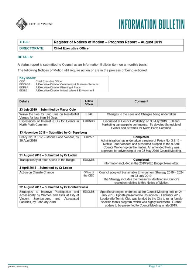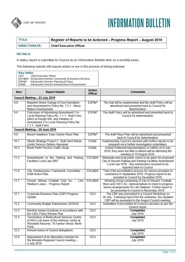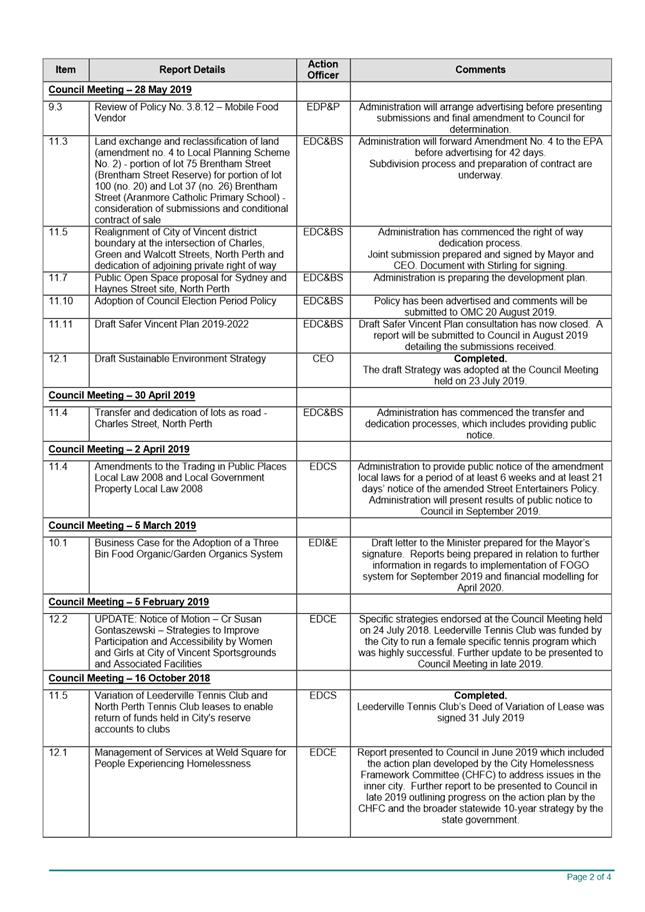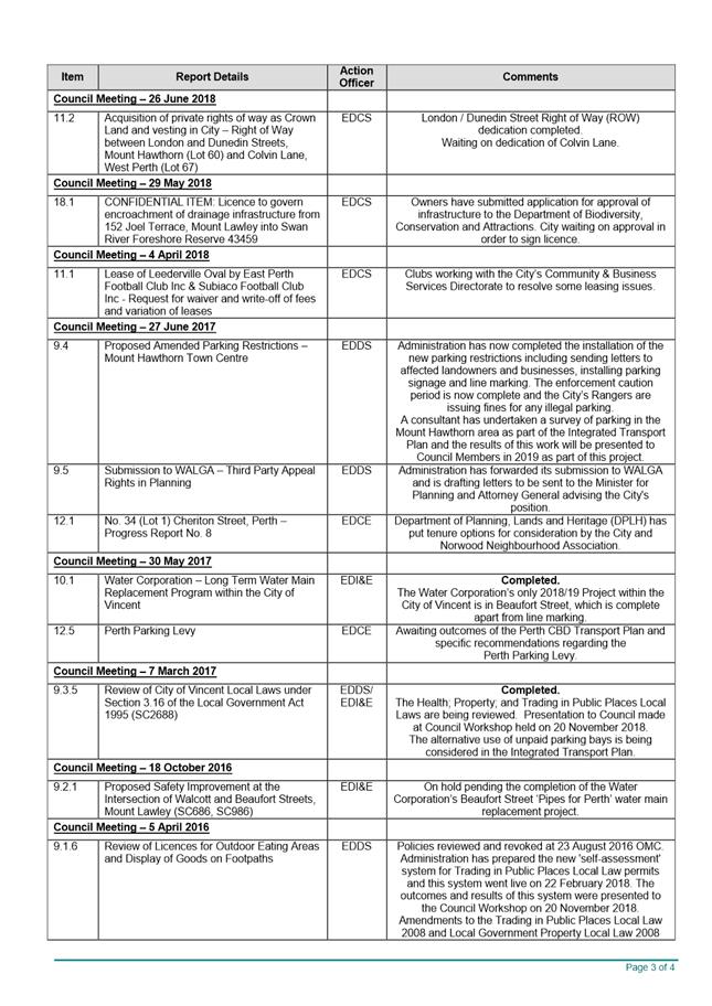
AGENDA
Council Briefing
13 August 2019
|
Time: |
6pm |
|
Location: |
Administration and Civic Centre 244 Vincent Street, Leederville |
David MacLennan
Chief Executive Officer
AGENDA
Council Briefing
13 August 2019
|
Time: |
6pm |
|
Location: |
Administration and Civic Centre 244 Vincent Street, Leederville |
David MacLennan
Chief Executive Officer
Council Briefing Agenda 13 August 2019
DISCLAIMER
No responsibility whatsoever is implied or accepted by the City of Vincent (City) for any act, omission, statement or intimation occurring during Council Briefings or Council Meetings. The City disclaims any liability for any loss however caused arising out of reliance by any person or legal entity on any such act, omission, statement or intimation occurring during Council Briefings or Council Meetings. Any person or legal entity who acts or fails to act in reliance upon any statement, act or omission made in a Council Briefing or Council Meeting does so at their own risk.
In particular and without derogating in any way from the broad disclaimer above, in any discussion regarding any planning or development application or application for a licence, any statement or intimation of approval made by an Elected Member or Employee of the City during the course of any meeting is not intended to be and is not to be taken as notice of approval from the City. The City advises that anyone who has any application lodged with the City must obtain and should only rely on WRITTEN CONFIRMATION of the outcome of the application, and any conditions attaching to the decision made by the Council in respect of the application.
Copyright
Any plans or documents contained within this Agenda may be subject to copyright law provisions (Copyright Act 1968, as amended) and that the express permission of the copyright owner(s) should be sought prior to their reproduction. It should be noted that Copyright owners are entitled to take legal action against any persons who infringe their copyright. A reproduction of material that is protected by copyright may represent a copyright infringement.
PROCEDURE FOR PUBLIC SPEAKING TIME
The City of Vincent Local Law Relating to Meeting Procedures prescribes the procedure for persons to ask questions or make public statements relating to a matter affecting the City, either verbally or in writing, at a Council meeting.
Questions or statements made at an Ordinary Council meeting can relate to matters that affect the City. Questions or statements made at a Special Meeting of the Council must only relate to the purpose for which the meeting has been called.
1. Shortly after the commencement of the meeting, the Presiding Member will ask members of the public to come forward to address the Council and to give their name and the suburb in which they reside or, where a member of the public is representing the interests of a business, the suburb in which that business is located and Agenda Item number (if known).
2. Public speaking time will be strictly limited to three (3) minutes per member of the public.
3. Members of the public are encouraged to keep their questions/statements brief to enable everyone who desires to ask a question or make a statement to have the opportunity to do so.
4. Public speaking time is declared closed when there are no further members of the public who wish to speak.
5. Questions/statements are to be directed to the Presiding Member and are to be made politely in good faith and are not to be framed in such a way as to reflect adversely or be defamatory on a Council Member or City Employee.
6. Where the Presiding Member is of the opinion that a member of the public is making a statement at a Council meeting, that does not affect the City, he may ask the person speaking to promptly cease.
7. Questions/statements and any responses will be summarised and included in the Minutes of the Council meeting.
8. Where practicable, responses to questions will be provided at the meeting. Where the information is not available or the question cannot be answered, it will be “taken on notice” and a written response will be sent by the Chief Executive Officer to the person asking the question. A copy of the reply will be included in the Agenda of the next Ordinary meeting of the Council.
9. It is not intended that public speaking time should be used as a means to obtain information that would not be made available if it was sought from the City’s records under Section 5.94 of the Local Government Act 1995 or the Freedom of Information (FOI) Act 1992. The CEO will advise the member of the public that the information may be sought in accordance with the FOI Act 1992.
RECORDING AND WEBSTREAMING OF COUNCIL MEETINGS
· All Ordinary and Special Council Meetings are electronically recorded except when the Council resolves to go behind closed doors;
· All recordings are retained as part of the City's records in accordance with the General Disposal Authority for Local Government Records produced by the Public Records Office;
· A copy of the recorded proceedings and/or a transcript of a particular section or all of a Council meeting is available in accordance with Policy No. 4.2.4 – Council Meetings – Recording and Web Streaming.
· Ordinary Meetings of Council and Council Briefings are streamed live on the internet in accordance with the City’s Policy – 4.2.4 - Council Meetings Recording and Web Streaming. It is another way the City is striving for transparency and accountability in what we do.
· The live stream can be accessed from http://webcast.vincent.wa.gov.au/video.php
· Images of the public gallery are not included in the webcast, however the voices of people in attendance may be captured and streamed.
· If you have any issues or concerns with the live streaming of meetings, please contact the City’s Manager Governance and Risk on 08 9273 6538.
Council Briefing Agenda 13 August 2019
1 Declaration of Opening / Acknowledgement of Country
2 Apologies / Members on Leave of Absence
3 Public Question Time and Receiving of Public Statements
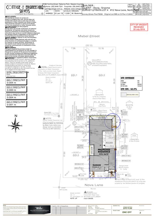
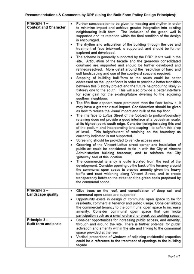
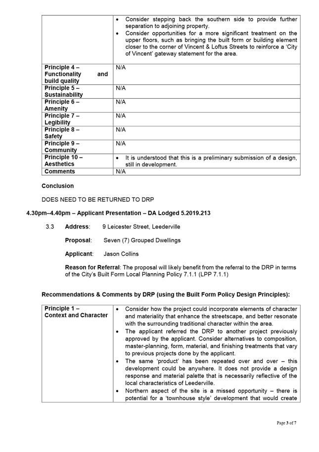
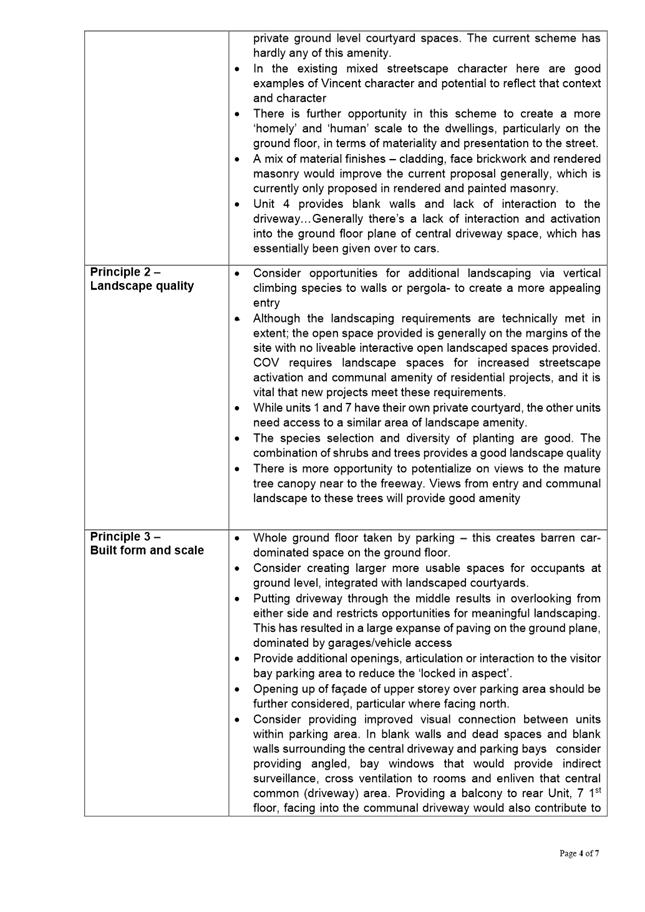
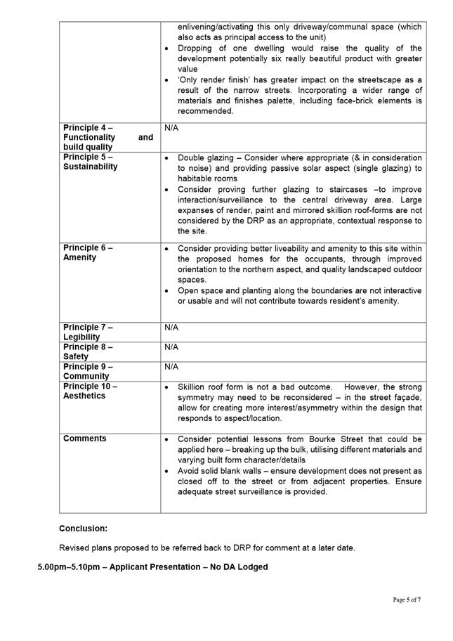
5.2 No. 12 (Lot: 4, S/P: 78266) Nova Lane, North Perth - Single Dwelling
5.5 No. 11 (Lot: 1; D/P: 12979) Buxton Street, Mount Hawthorn - Proposed Single House
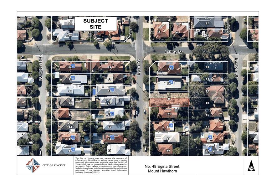
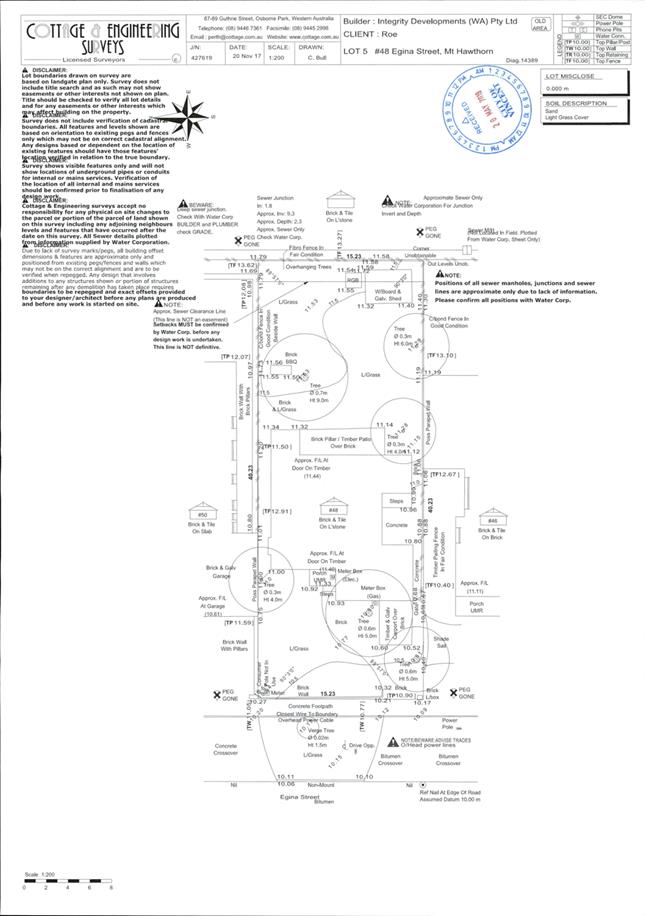
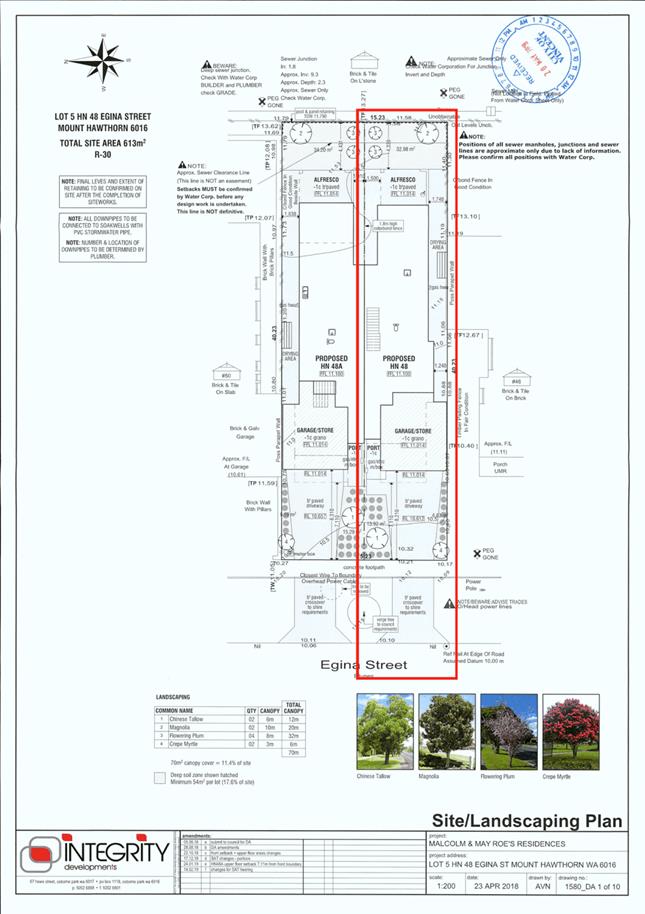
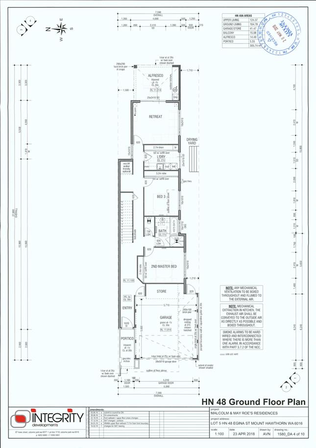
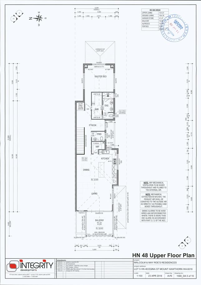
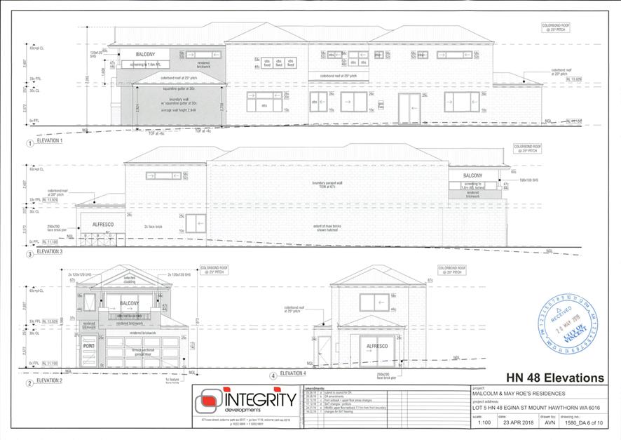
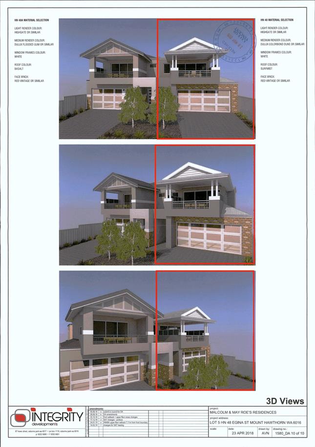
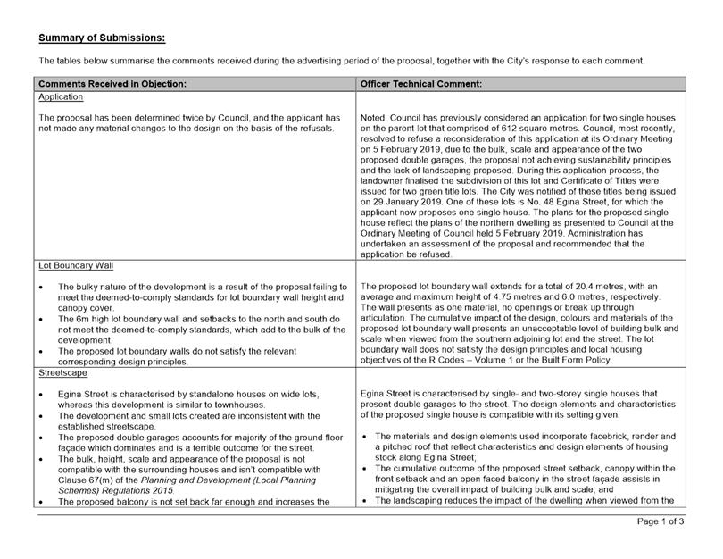
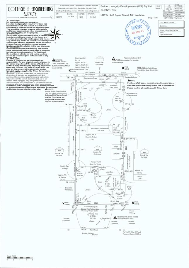
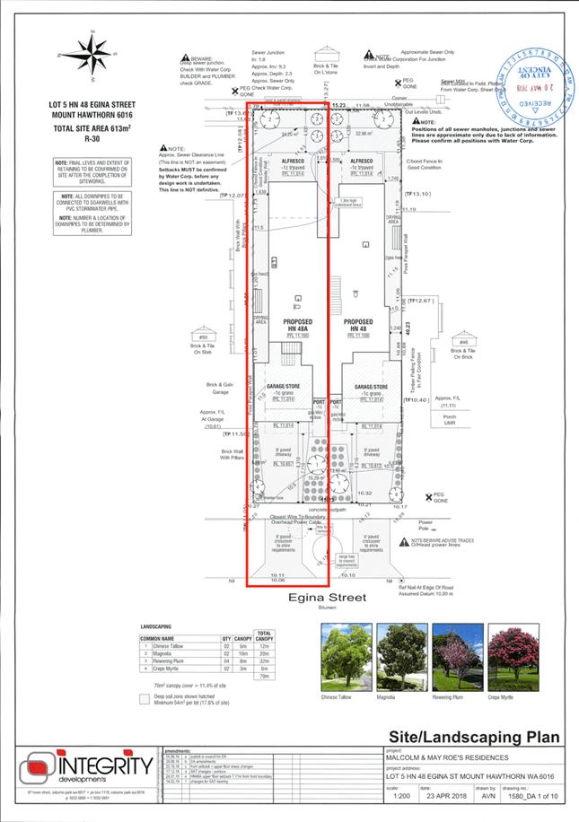
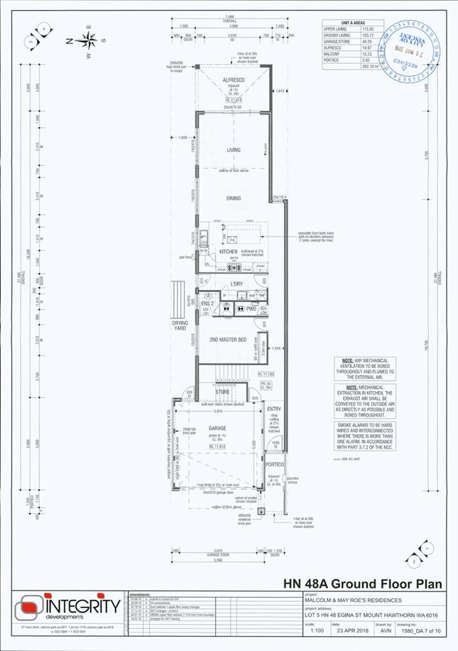
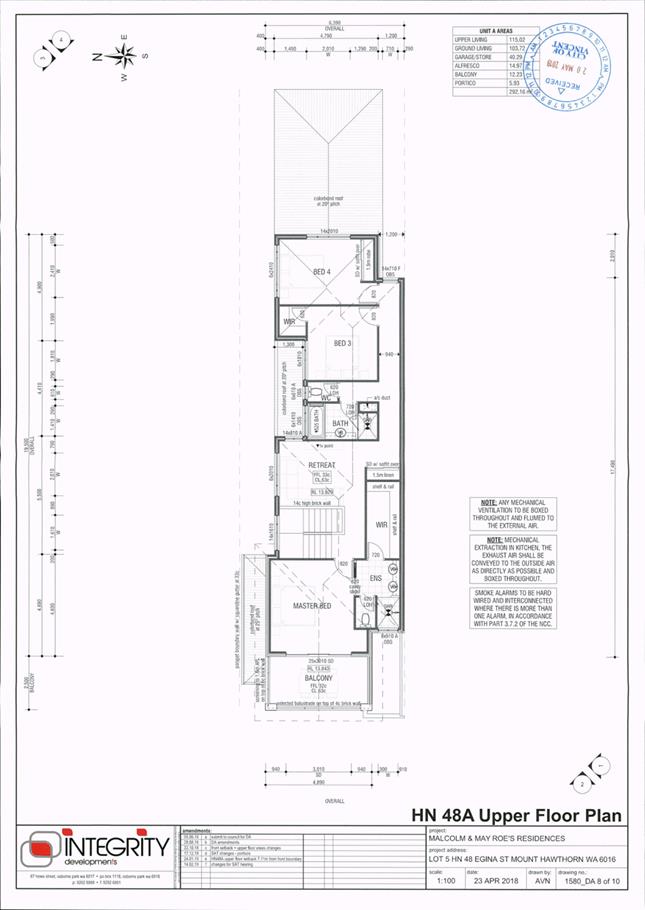
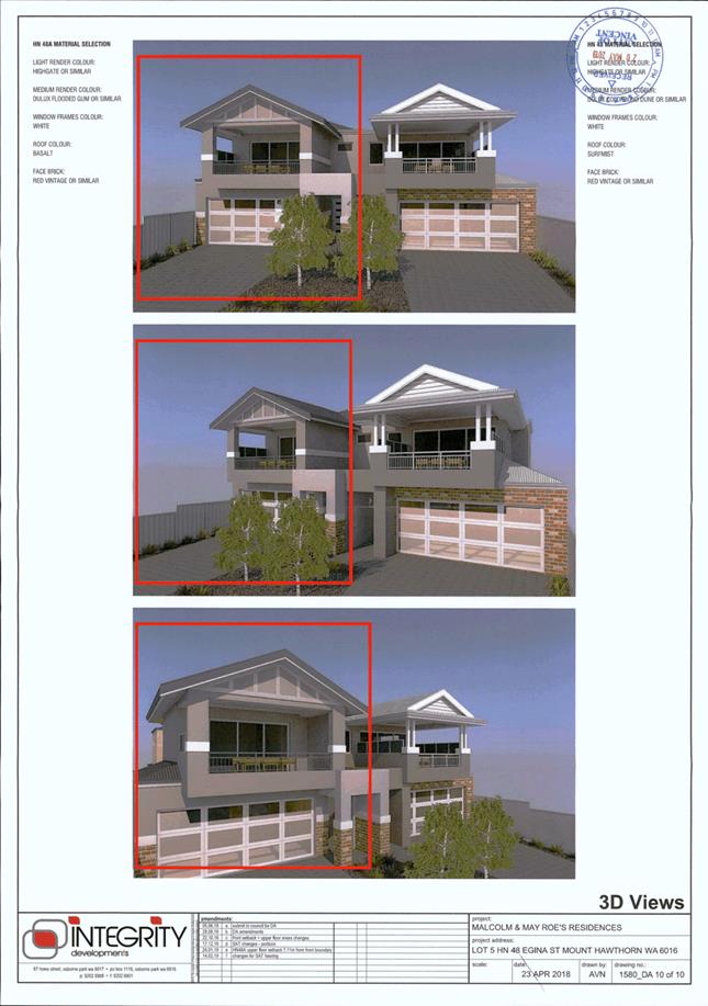
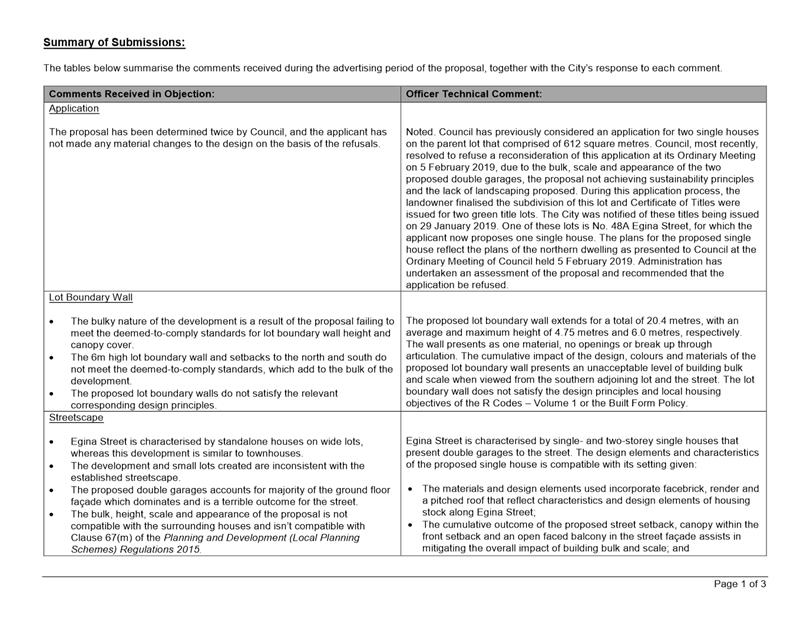
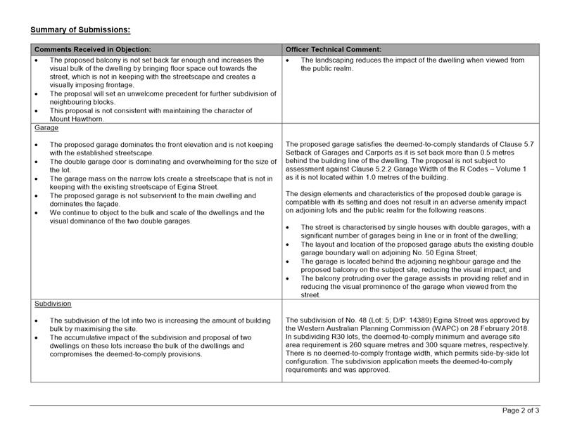
5.6 No. 48 (Lot: 202; D/P: 413236) Egina Street, Mount Hawthorn - Proposed Single House
5.7 No. 48A (Lot: 201; D/P: 413236) Egina Street, Mount Hawthorn - Proposed Single House
5.8 Food Stallholder Fees - Minor Review [ABSOLUTE MAJORITY DECISION REQUIRED]
6 Infrastucture and Environment
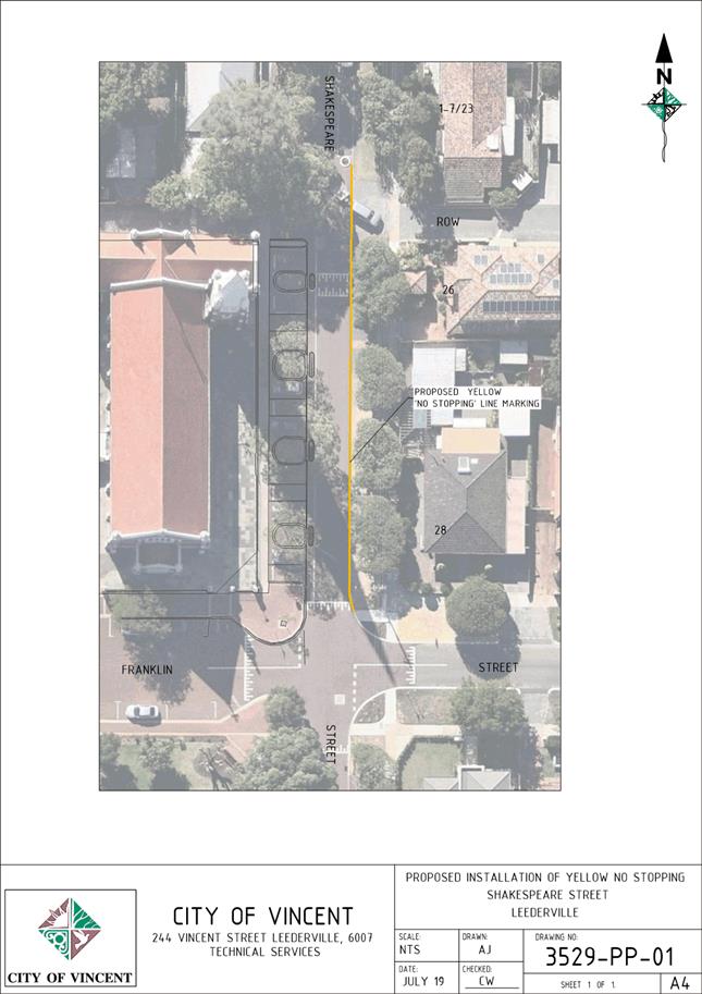
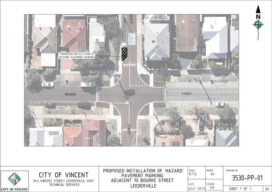
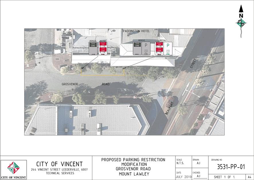
6.1 Minor Parking Restriction Improvements/Amendments
7 Community and Business Services
7.1 LATE REPORT: Investment Report as at 31 July 2019
7.2 LATE REPORT: Authorisation of Expenditure for the period 1 July 2019 to 31 July 2019
7.3 LATE REPORT: Financial Statements as at 31 July 2019
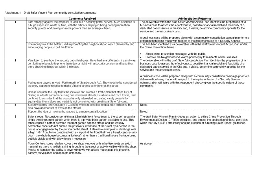
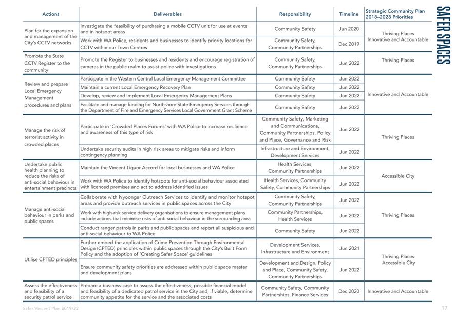
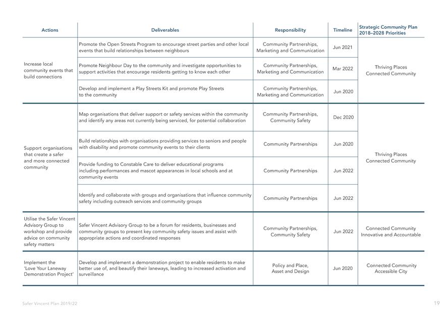
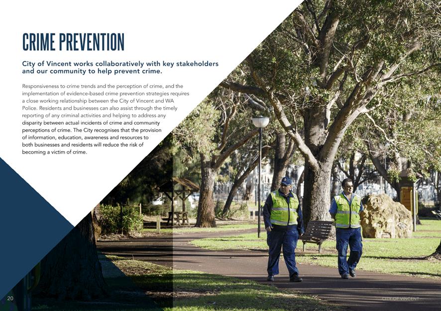
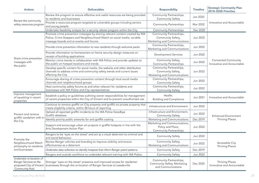
7.4 Draft Safer Vincent Plan 2019-2022
7.5 LATE REPORT: Pop-Up Play Consultation Results
8.2 Adoption of Council Election Period Policy
8.3 LATE REPORT: Annual Corporate Business Plan (CBP) Review and Update
8.4 2019 Organisational Review
9 Motions of Which Previous Notice Has Been Given
9.1 Notice of Motion - Cr Dan Loden - Asbestos Awareness
10 Representation on Committees and Public Bodies
11 Confidential Items/Matters For Which The Meeting May Be Closed (“Behind Closed Doors")
11.1 Chief Executive Officer's Annual Performance Review October 2018 - June 2019
“The City of Vincent would like to acknowledge the Traditional Owners of the land, the Whadjuk people of the Noongar nation and pay our respects to Elders past, present and emerging”.
2 Apologies / Members on Leave of Absence
Nil
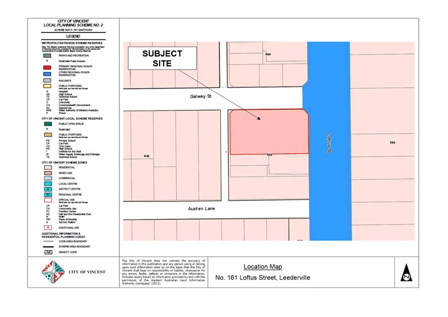
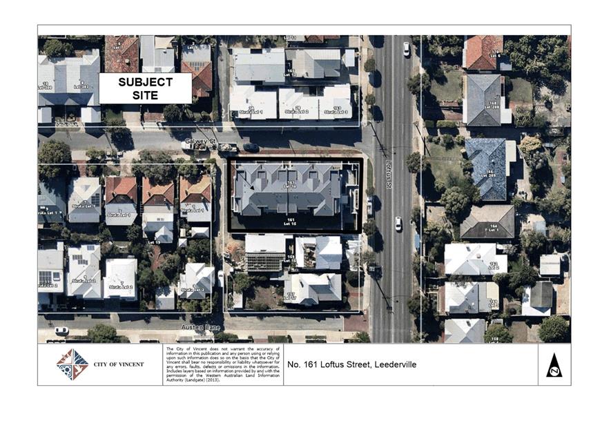
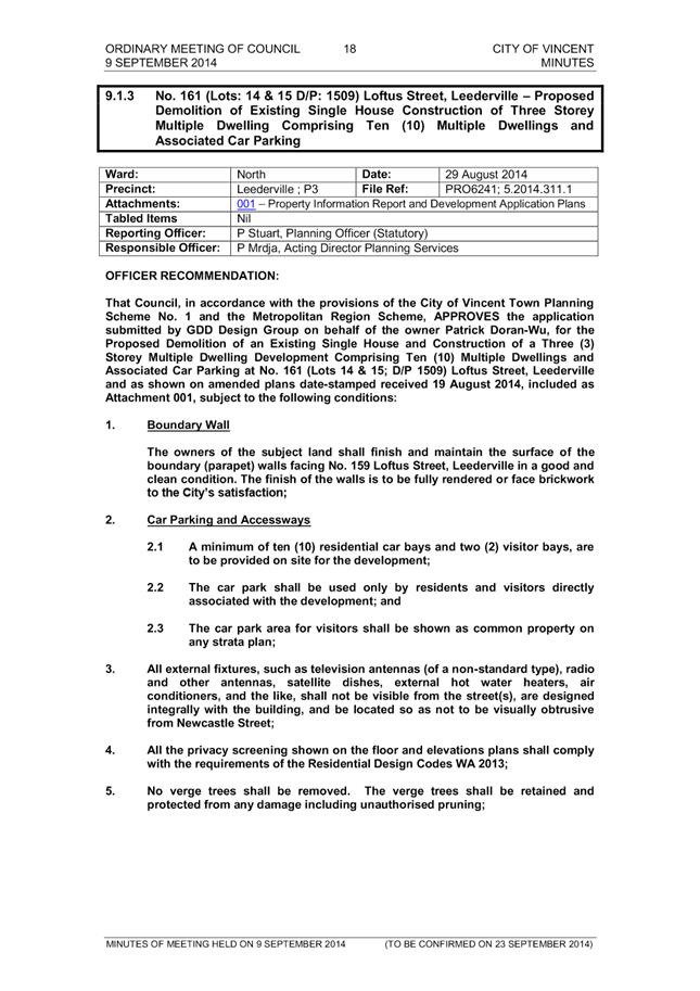
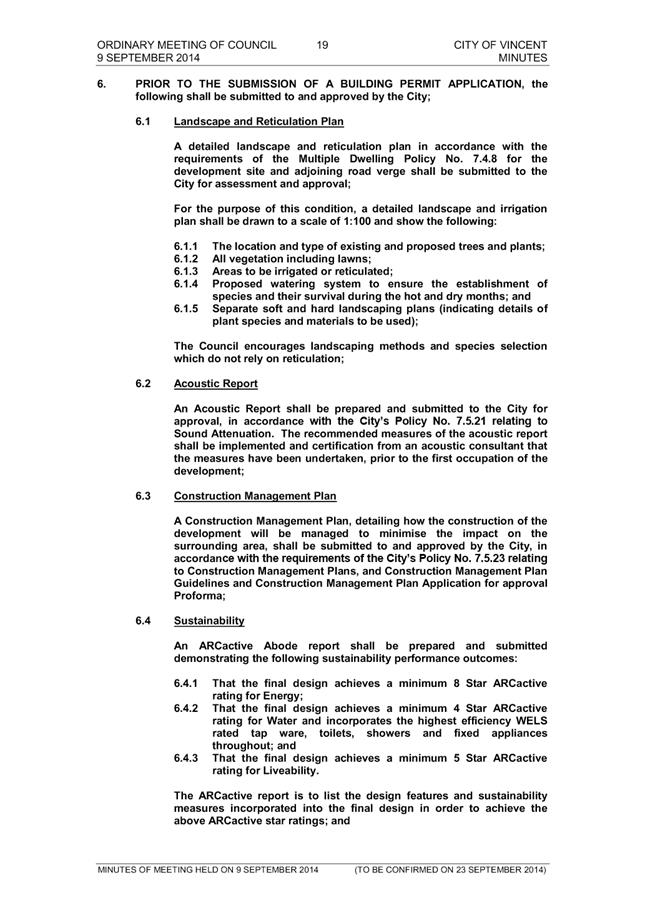
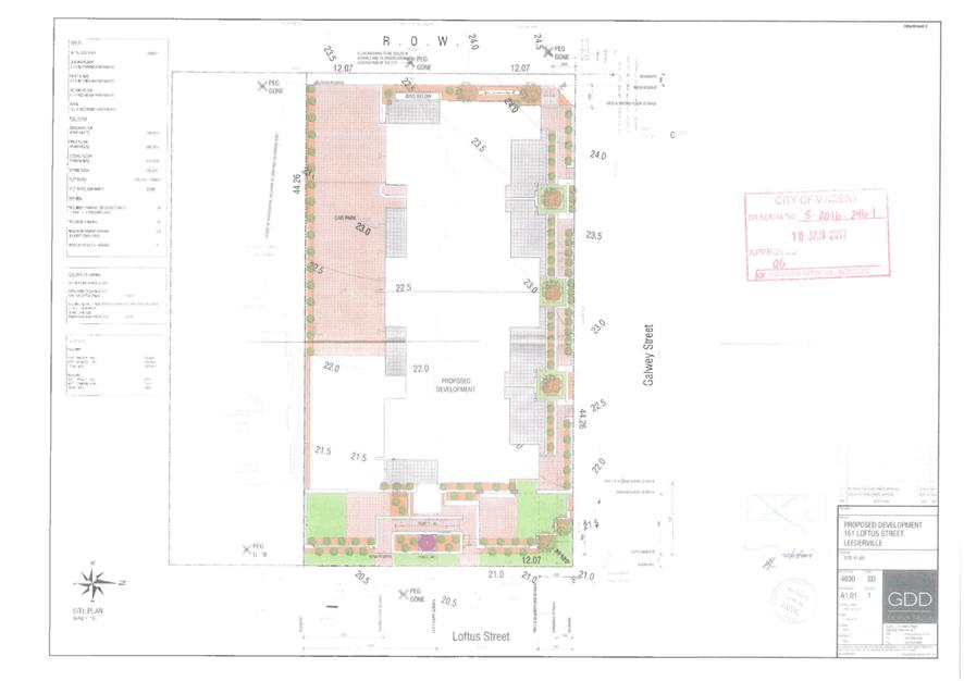
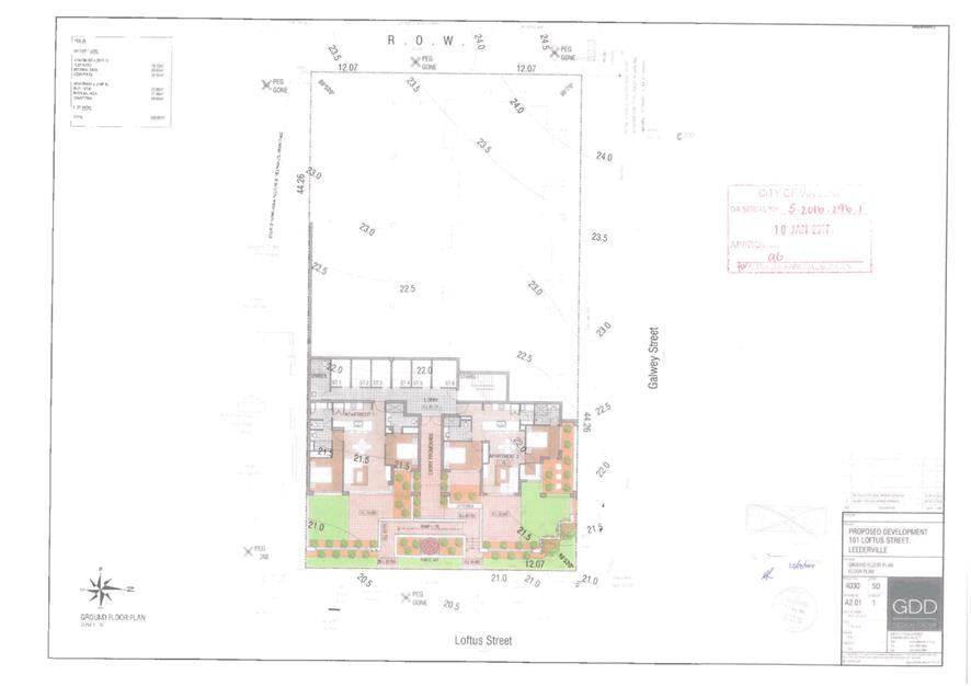
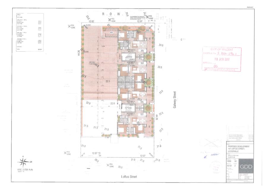
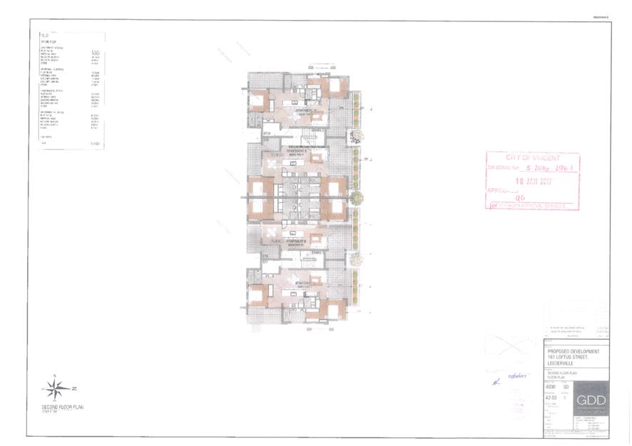
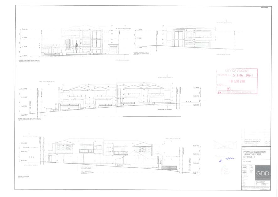
5.1 No. 161 (Lot: 890; D/P: 413584) Loftus Street, Leederville - Ten Multiple Dwellings (Amendment to Approval)
TRIM Ref: D19/105970
Author: Karsen Reynolds, Urban Planner
Authoriser: Joslin Colli, Coordinator Planning Services
Ward: North
Attachments: 1. Location
Map ⇩ ![]()
2. Minutes of the 9
September 2014 Council Meeting ⇩ ![]()
3. Minutes of the 18
December 2016 Council Meeting ⇩ ![]()
4. Previously
Approved Development Plans ⇩ ![]()
|
That Council, in accordance with the provisions of the City of Vincent Local Planning Scheme No. 2 and the Metropolitan Region Scheme, APPROVES the development application for Ten Multiple Dwellings (amendment to approval) at No. 161 (Lot: 890; D/P: 413584) Loftus Street, subject to the following conditions: 1. All conditions, requirements and advice notes detailed on development approval 5.2014.311.1 and 5.2016.296.1 granted on 9 September 2019 and 13 December 2016 respectively continue to apply to this approval, except as follows: 1.1 Condition 7 of the development approval is deleted and replaced with the following condition: 7. Public Art 7.1 In accordance with City of Vincent Policy 7.5.13 Percent for Art the application is required to make a public art contribution of $25,000 being one percent of the $2,500,000 through one of the following options: 1. Option 1: Owner/Applicant chooses to co-ordinate the Public Art project themselves or by engaging an art consultant 2. 3. Or 4. 5. Option 2: Owner/Applicant chooses to pay cash-in-lieu. Owner/Applicants who choose Option 2 would receive a 15% discount on the Percent for Art contribution. 7.2 The owner(s), or the applicant on behalf of the owner(s), shall comply with the City of Vincent Percent for Public Art Policy No. 7.5.13: 6. (1) Option 1 – 7. Within 30 days of development approval, obtain approval for the Public Art Project and associated Artist; and 8. 9. Within 90 days of development approval, install the approved public art project, and thereafter maintain the art work; 10. 11. OR 12. 13. (2) Option 2 – 14. Within 30 days of development approval pay the above cash-in-lieu contribution amount. |
Purpose of Report:
To consider an application for development approval for an amendment to condition of development approval for ten Multiple Dwellings at No. 161 Loftus Street, Leederville (subject site).
PROPOSAL:
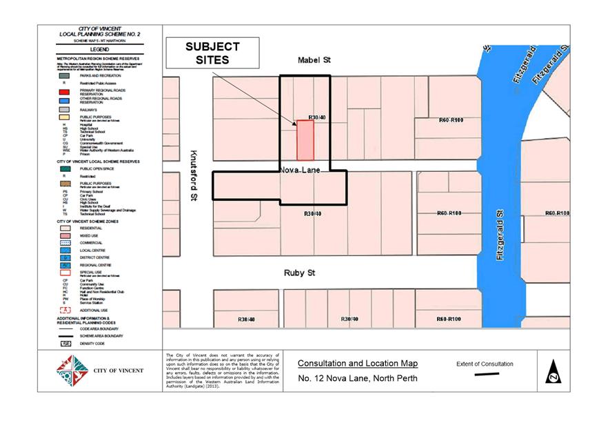
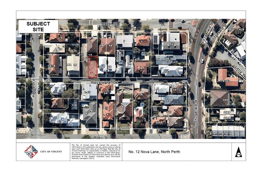
The subject site is located at No. 161 Loftus Street, Leederville, as shown on the location plan included as Attachment 1.
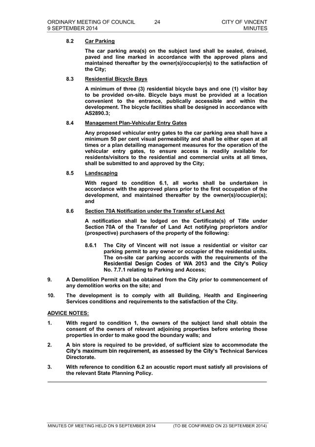
At its Ordinary Council Meeting held on 9 September 2014, Council approved an application for Demolition of Existing Single House Construction of Three Storey Multiple Dwelling Comprising 10 Multiple Dwellings and Associated Car Parking subject to conditions at the subject site. The Minutes of the 9 September 2014 Ordinary Council Meeting are included as Attachment 2.
A condition of the development approval required a public art contribution to be made in accordance with the City’s Policy No. 7.5.13 – Percent for Public Art (Percent for Public Art Policy). The City’s Percent for Public Art Policy prescribes a minimum of one percent of the total project cost to be allocated to the contribution of public art appurtenant to the development. This equated to a contribution of $29,568, being one percent of the $2,956,800 value of the development. On 17 October 2014 the applicant submitted a statutory declaration that advised the applicant had chosen to pay the cash-in-lieu Percent for Public Art contribution.
The development was not substantially commenced within two years of the development approval. A development application for an Extension of the Term of Approval was lodged with the City on 18 July 2016. As part of the application, the applicant advised the City that the cost of development had reduced to $2,500,000 as a result of a change in contractors.
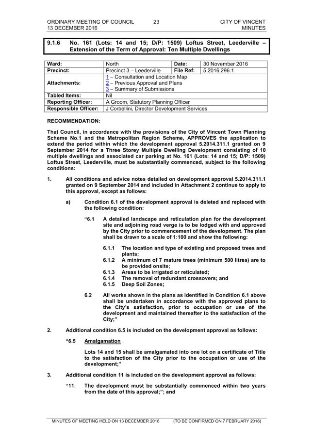
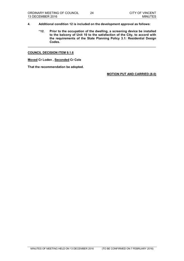
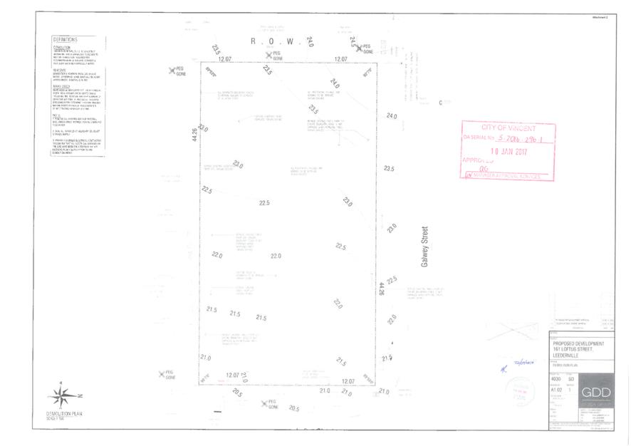
The extension of the time development application was approved by Council at its Ordinary Council Meeting on 13 December 2016. As part of the approval, the Percent for Public Art contribution condition was not amended to reflect the reduced cost of development. The Minutes of the 13 December 2016 Ordinary Council Meeting are included as Attachment 3, and the development plans approved by Council are included as Attachment 4.
This development application proposes to amend the existing approval by amending Condition 7 that relates to the Percent for Public Art Contribution to reflect the reduced cost of development.
The application does not propose any changes to the overall design and built form outcome of the development.
Background:
|
Landowner: |
Patrick Doran-Wu |
|
Applicant: |
Patrick Doran-Wu |
|
Date of Application: |
1 July 2019 |
|
Zoning: |
MRS: Urban LPS2: Zone: Residential R Code: R60 |
|
Built Form Area: |
Transit Corridor |
|
Existing Land Use: |
Dwelling (Multiple) |
|
Proposed Use Class: |
Dwelling (Multiple) |
|
Lot Area: |
1011m² |
|
Right of Way (ROW): |
Yes – 5.0 metres |
|
Heritage List: |
No |
The subject site is bound by Loftus Street to the east, Gawley Street to the north, a ROW to the west, and residential development to the south. A location plan is included in Attachment 1.
The subject site and adjoining northern, western and southern properties are zoned Residential R60 under the City’s Local Planning Scheme No. 2 (LPS2) and are located within the Transit Corridor built form area under the City’s Policy No. 7.1.1 – Built Form. The adjoining properties to the west of the subject site are zoned Residential R40 under LPS2 and are within the Residential built form area.
The construction of the ten multiple dwellings was completed in April 2019. The applicant has satisfied all other conditions of approval, and the occupancy permit was approved in May 2019.
Details:
Not applicable.
Consultation/Advertising:
The application has been reviewed against the City’s Policy No. 4.1.5 – Community Consultation (Community Consultation Policy) and it was determined that the proposal did not require advertising for the following reasons:
· There is no external changes to the built form of the existing multiple dwelling development previously approved by Council; and
· The proposed amendment would not have a significant impact on the community, or the economy, lifestyle, amenity and/or environment of any member of the community or community group.
Design Review Panel (DRP):
Referred to DRP: No
The amended development application was not referred to the DRP for comment as the amendments do not result in any built form changes.
Legal/Policy:
· Planning and Development Act 2005;
· Planning and Development (Local Planning Schemes) Regulations 2015;
· City of Vincent Local Planning Scheme No. 2;
· Policy No. 4.1.5 – Community Consultation; and
· Policy No. 7.5.13 – Percent for Public Art.
Should Council refuse the application for development approval, the applicant would have the right to have the decision reviewed in accordance with Part 14 of the Planning and Development Act 2005.
Delegation to Determine Applications:
This matter has been referred to Council in accordance with the City’s Delegated Authority Register as the application is an amendment to a development approval that was determined by Council.
Risk Management Implications:
There are minimal risks to Council and the City’s business function when Council exercises its discretionary power to determine a planning application.
Strategic Implications:
This is in keeping with the City’s Strategic Community Plan 2018-2028:
Innovative and Accountable
We are open and accountable to an engaged community.
SUSTAINABILITY IMPLICATIONS:
Nil.
Financial/Budget Implications:
Nil.
Comments:
The proposal to amend the condition of approval relating to Public Art Contribution is consistent with the reduced cost of development. If approved, the percent for public art contribution would be reduced from $29,568 to $25,000, being 1 percent of the estimated total cost of the development of $2,500,000. The applicant has indicated that they wish to proceed with Option 2 (cash-in-lieu option). This option permits a 15 percent discount to be applied to the amount of $25,000 in accordance with the Percent for Public Art Policy. The resultant cash-in-lieu contribution would be $21,250. The amended condition however allows for either Option 1 or Option 2 of the Percent for Public Art Policy to be chosen by the applicant.
The proposal does not result in any external changes or increase to the existing building footprint. The amendment would not have any impact on the surrounding area. It is recommended that Council approves this amended development application.
TRIM Ref: D19/94233
Author: Natasha Trefry, Urban Planning Advisor
Authoriser: Joslin Colli, Coordinator Planning Services
Ward: North
Attachments: 1. Consultation
and Location Plan ⇩ ![]()
2. Development Plans
⇩ ![]()
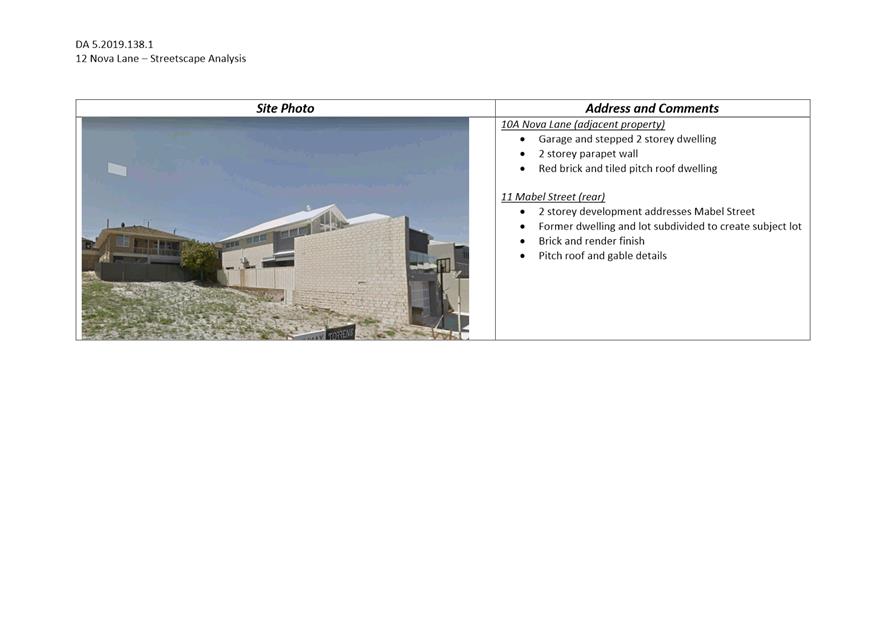
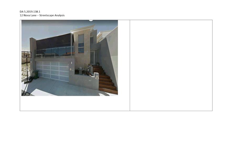
3. Streetscape
Analysis ⇩ ![]()
4. Applicant
Justification ⇩ ![]()
5. Determination
Advice Notes ⇩ ![]()
|
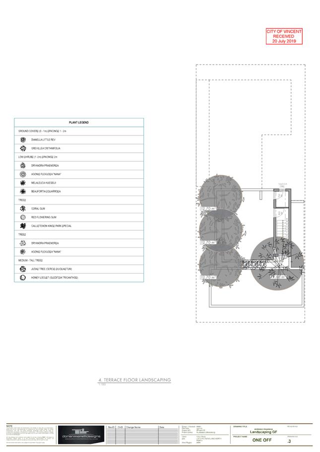
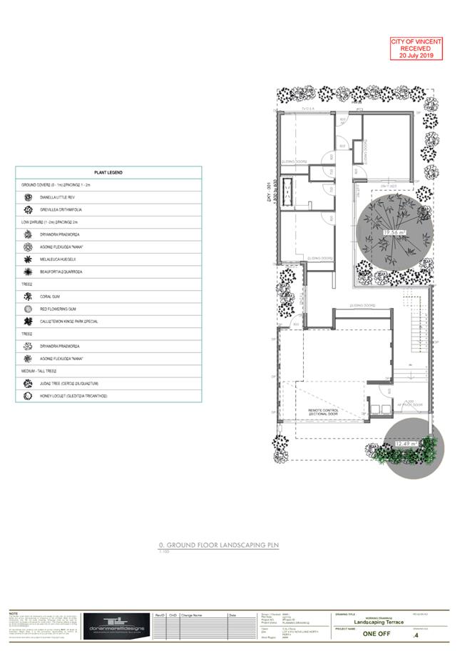
That Council, in accordance with the provisions of the City of Vincent Local Planning Scheme No. 2 and the Metropolitan Region Scheme, APPROVES, the development application for Single Dwelling at No. 12 (Lot: 4; S/P78266) Nova Lane, North Perth in accordance with the plans in Attachment 2, subject to the following conditions, with the associated advice notes in Attachment 5: 1. Boundary Walls The owners of the subject land shall finish and maintain the surface of the boundary walls facing No. 12A Nova Lane and No. 10A Nova Lane in a good and clean condition prior to the practical completion of the development and thereafter maintained to the satisfaction of the City. The finish of the walls are to be fully rendered or facebrick to the satisfaction of the City; 2. Landscaping Plan 2.1 A detailed landscape and reticulation plan for the development site and adjoining road verge, to the satisfaction of the City, shall be lodged with and approved by the City prior to lodgement of a Building Permit. The plan shall be drawn to a scale of 1:100 and show the following: · The location and type of proposed trees and plants; · Areas to be irrigated or reticulated; · The provision of 15 percent of the site area as deep soil zone and 30 percent canopy cover at maturity; and 2.2 All works shown in the plans as identified in Condition 2.1 above shall be undertaken in accordance with the approved plans to the City’s satisfaction, prior to occupancy or use of the development and maintained thereafter to the satisfaction of the City at the expense of the owners/occupiers; 3. Sight Lines No walls, letterboxes or fences above 0.75 metres in height to be constructed within the 1.5 metre of where: 3.1 walls, letterboxes or fences adjoin vehicular access points to the site; or 3.2 a driveway meets a public street; or 3.3 two streets intersect; unless otherwise approved by the City of Vincent;
4. Stormwater All stormwater produced on the subject land shall be retained on site, by suitable means to the full satisfaction of the City; 5. Car Parking and Access 5.1 The car parking and access areas shall be sealed, drained and paved in accordance with the approved plans and are to comply with the requirements of AS2890.1 prior to occupancy or use of the development; 5.2 Vehicle access points are required to match into existing right of way levels; and 5.3 All new crossovers shall be constructed in accordance with the City’s Standard Crossover Specifications; 6. Visual Privacy Prior to occupancy or use of the development, all windows from the Master Suite, Kitchen and Family/Dining area shall be glazed in an obscure material and permanently fixed to comply in all respects with the requirements of Clause 5.4.1 of the Residential Design Codes (Visual Privacy) deemed-to-comply provisions, to the satisfaction of the City; 7. External Fixtures All external fixtures, such as television antennas (of a non-standard type), radio and other antennaes, satellite dishes, solar panels, external hot water heaters, air conditioners, and the like, shall not be visible from the street(s), are designed integrally with the building, and be located so as not to be visually obtrusive; and 8. Detailed Schedule of External Finishes Prior to the commencement of development a detailed schedule of external finishes (including materials and colour schemes and details) shall be submitted to and approved by the City. The development shall be finished in accordance with the approved schedule prior to the use or occupation of the development. |
Purpose of Report:
To consider an application for development approval for a single dwelling at 12 Nova Lane, North Perth (subject site).
PROPOSAL:
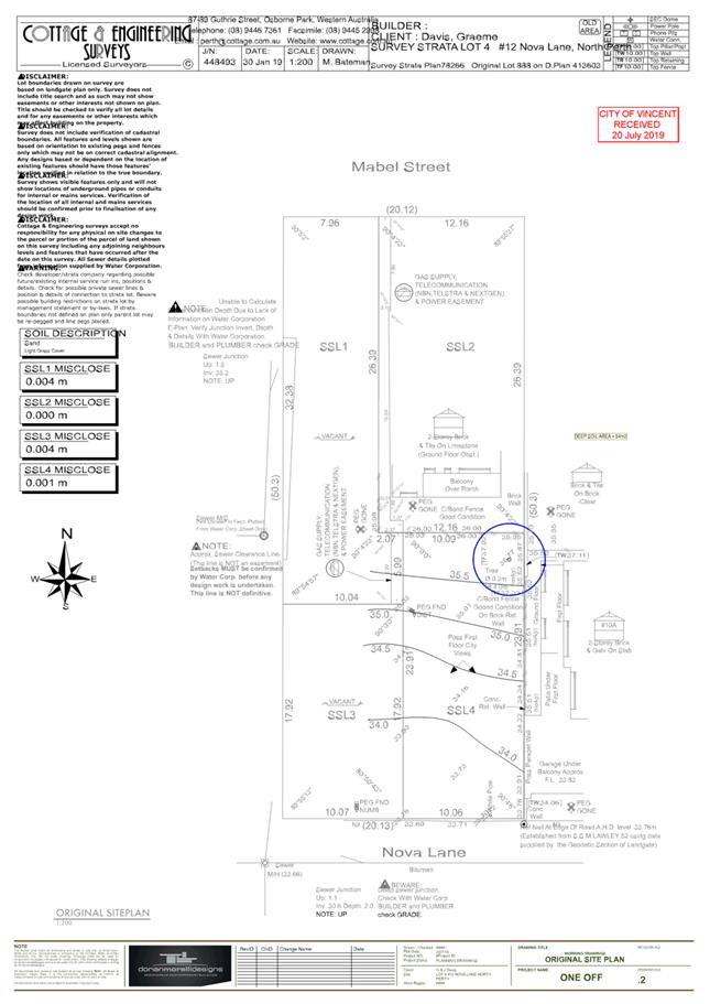
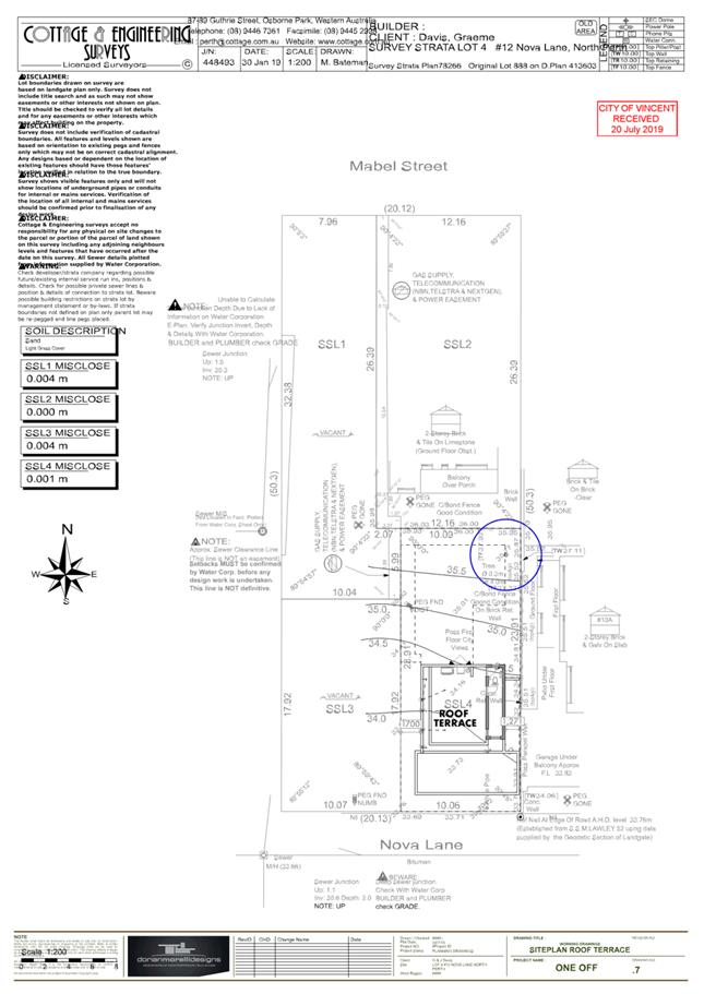
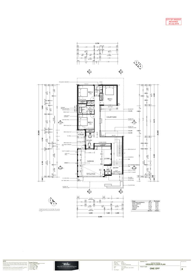
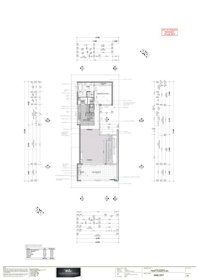
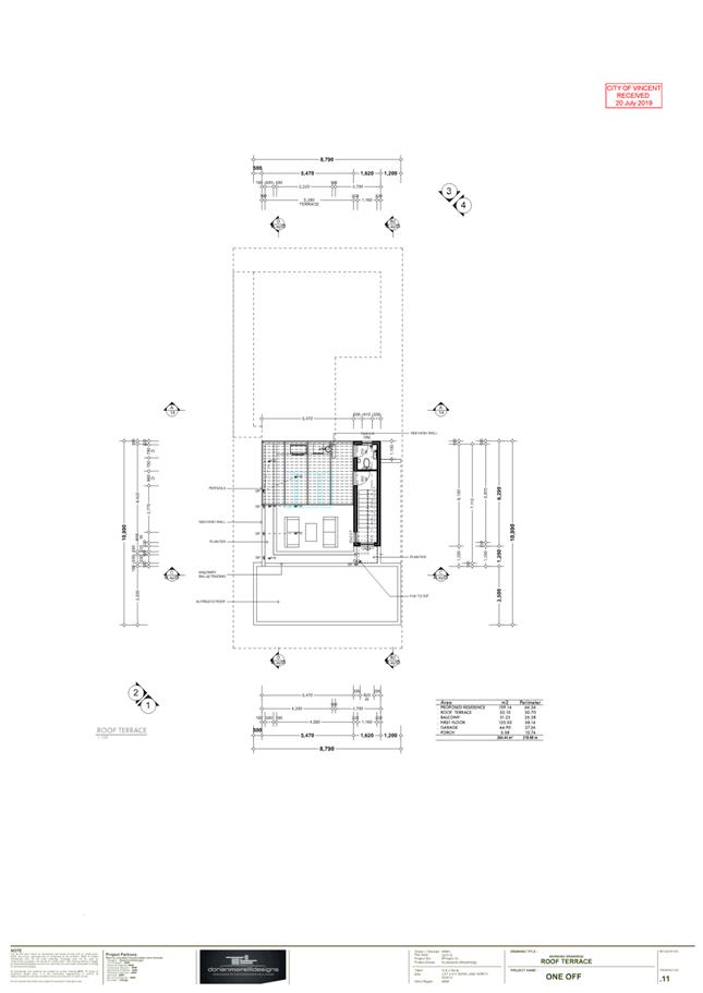
The application proposes a three storey dwelling to a vacant survey strata lot which has been subdivided. The third storey element of the dwelling compromises a covered stairwell and bathroom, as well as a centrally located terrace with a pergola.
Background:
|
Landowner: |
Graeme and Janice Davis |
|
Applicant: |
Dorian Morelli |
|
Date of Application: |
12 April 2019 |
|
Zoning: |
MRS: Urban LPS2: Residential R30/40 R Code: R30/40 |
|
Built Form Area: |
Residential |
|
Existing Land Use: |
Vacant Land |
|
Proposed Use Class: |
Single Dwelling |
|
Lot Area: |
241m² |
|
Right of Way (ROW): |
Yes Nova Lane to the south – 6.8 metre wide, drained and sealed |
|
Heritage List: |
No |
The subject site is bound by Nova Lane to the south, a single storey single house to the north, a two storey dwelling to the east and a vacant lot to the west. Administration notes an application for a three storey dwelling has been submitted for No. 12A Nova Lane (western property) which forms part of the parent lot and is currently vacant. A location plan is included as Attachment 1.
The subject site is zoned Residential R30/40 and is affected by Clause 26(1) of City’s Local Planning Scheme No. 2 (LPS2) which states: development will only be permitted to R40 standards where the existing house is retained. The subject site was created through a survey strata subdivision which retained the existing house at No. 11 Mabel Street, North Perth. The application has been assessed against the development requirements of R40.
The subject site and surrounding properties are zoned Residential R30/40. The subject site forms part of the Residential Built Form area in accordance with the City’s Policy No. 7.7.1 – Built Form.
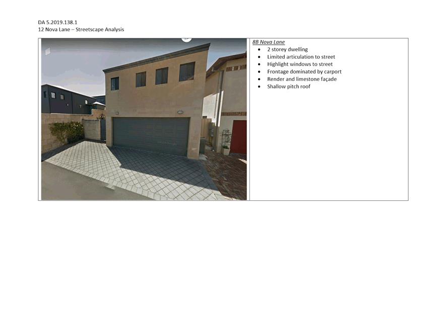
The application proposes a three storey dwelling, inclusive of an open roof terrace, which addresses Nova Lane. The development plans have been included as Attachment 2. A streetscape analysis of the adjacent and neighbouring dwellings is included, as Attachment 3.
Details:
Summary Assessment
The table below summarises the planning assessment of the proposal against the provisions of the LPS2, the City’s Policy No. 7.1.1 – Built Form and the State Government’s Residential Design Codes. In each instance where the proposal requires the discretion of Council, the relevant planning element is discussed in the Detailed Assessment section following from this table.
|
Planning Element |
Use Permissibility/ Deemed-to-Comply |
Requires the Discretion of Council |
|
Street Setback |
ü |
|
|
Front Fence |
ü |
|
|
Building Setbacks/Boundary Wall |
|
ü |
|
Building Height/Storeys |
|
ü |
|
Roof Form |
ü |
|
|
Open Space |
ü |
|
|
Outdoor Living Areas |
ü |
|
|
Landscaping |
ü |
|
|
Privacy |
ü |
|
|
Parking & Access |
|
ü |
|
Solar Access |
ü |
|
|
Site Works/Retaining Walls |
ü |
|
|
Essential Facilities |
ü |
|
|
External Fixtures |
ü |
|
|
Surveillance |
ü |
|
Detailed Assessment
The deemed-to-comply assessment of the elements that require the discretion of Council are as follows:
|
Lot Boundary Setbacks |
|
|
Deemed-to-Comply Standard |
Proposal |
|
Clause 5.3 of Built Form Policy
Roof Terrace (East): 1.4m
Lot Boundary Walls Maximum Height – 3.5m Average Height – 3.0m Permitted Length – 15.2m |
Roof Terrace (East): 1.3m
Lot Boundary Walls (East) Maximum Height – 6.9m Average Height – 6.6m Proposed Length – 9.9m (2 storey boundary wall proposed)
|
|
|
Lot Boundary Walls (West) Garage Maximum Height – 3.9m Average Height – 3.8m Proposed Length – 6.2m
|
|
|
Bed 2 – Bed 3 Maximum Height – 3.6m Average Height – 2.65m Proposed Length – 9.9m Western boundary total length: 16.1m |
|
Building Height |
|
|
Deemed-to-Comply Standard |
Proposal |
|
Clause 5.6 of Built Form Policy
Permitted Concealed Roof: 7.0 metres |
Proposed Concealed Roof: 9.0 metres |
|
Setback Garages & Carports |
|
|
Deemed-to-Comply Standard |
Proposal |
|
Clause 5.7 of Built Form Policy
Garage 0.5m behind building line of dwelling |
Garage 0.3m forward of building line of the dwelling |
The above elements of the proposal do not meet the specified deemed-to-comply standards and are discussed in the comments section below.
Consultation/Advertising:
Community Consultation was undertaken in accordance with the Planning and Development (Local Planning Scheme) Regulations 2015, for a period of 14 days commencing on 28 June 2019 – 12 July 2019. Community consultation was undertaken by means of written notifications with 18 letters sent to surrounding landowners, as shown in Attachment 1 and a notice on the City’s website. At the conclusion of the community consultation period, no submissions were received from the adjacent dwellings who were consulted regarding the proposal.
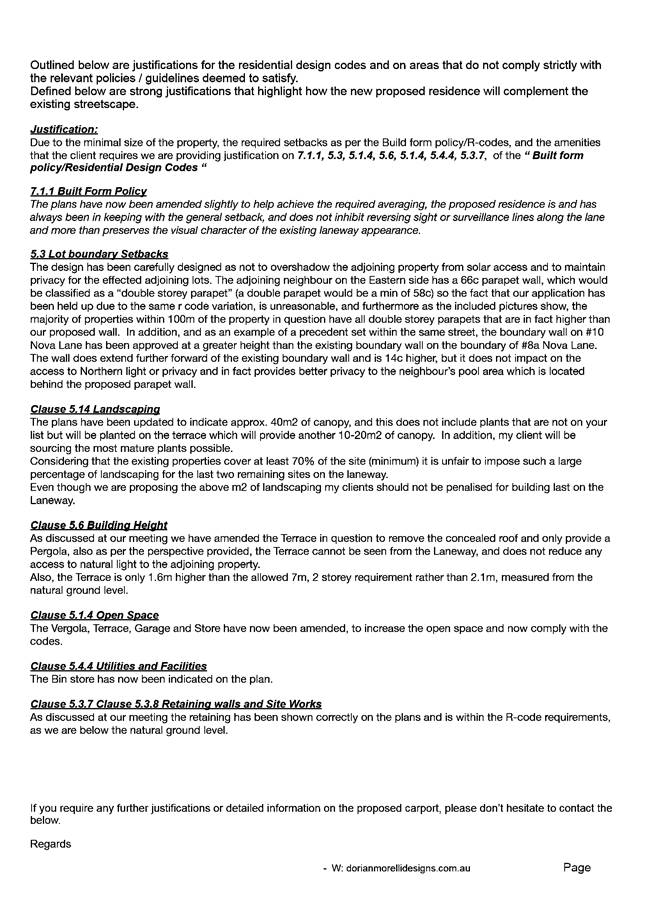
It is noted a variation to the street setback was advertised in error during the 14 day consultation period. Following the advertising period the applicant amended the development proposal by modifying the design and materials of the façade, reducing the size of the roof terrace and providing additional landscaping. The additional justification provided with the amended plans in regards to the visual privacy from the roof terrace are noted in Attachment 4.
Design Review Panel (DRP):
Referred to DRP: Yes
As the proposal sought variations to building height, the proposal was referred to the Chair of the DRP for comment. The comments received in regards to the proposal noted:
· The proposed design would be suitable, in the context of the surrounding streetscape providing the top level terrace would either:
o Have open flat pergola (or a louvered/ operable flat pergola);
o Have a flat (max 3deg) translucent roof;
· Once the terrace roof and portion of stair enclosure (above 1m balustrade level) are treated in any of the above manners, the design and form would be consistent with the adjacent properties.
The open nature of the pergola and its flat (concealed) roof form, are measures employed in the design of the third storey element which mitigate bulk and scale in accordance with the DRP Chair comments above and facilitate a built form outcome which is cognisant of the existing streetscape.
Legal/Policy:
· Planning and Development Act 2005;
· Planning and Development (Local Planning Schemes) Regulations 2015;
· City of Vincent Local Planning Scheme No. 2;
· State Planning Policy 3.1 – Residential Design Codes;
· Policy No. 4.1.5 – Community Consultation; and
· Policy No. 7.1.1 – Built Form Policy.
Delegation to Determine Applications:
The matter is being referred to Council as the application proposes a height of three storeys or more, which does not meet the deemed-to-comply building height.
Risk Management Implications:
There are minimal risks to Council and the City’s business function when Council exercises its discretionary power to determine a planning application.
Strategic Implications:
This is in keeping with the City’s Strategic Community Plan 2018-2028:
Innovative and Accountable
We are open and accountable to an engaged community.
SUSTAINABILITY IMPLICATIONS:
Nil.
Financial/Budget Implications:
Nil.
Comments:
Lot Boundary Setbacks
Eastern Boundary
The application proposes a 1.3 metre setback to the eastern boundary of the roof terrace in lieu of the 1.4 metre deemed-to-comply standard.
The proposed eastern setback is considered to satisfy the relevant design principles and local housing objectives of the R Codes and Built Form Policy and is considered acceptable for the following reasons:
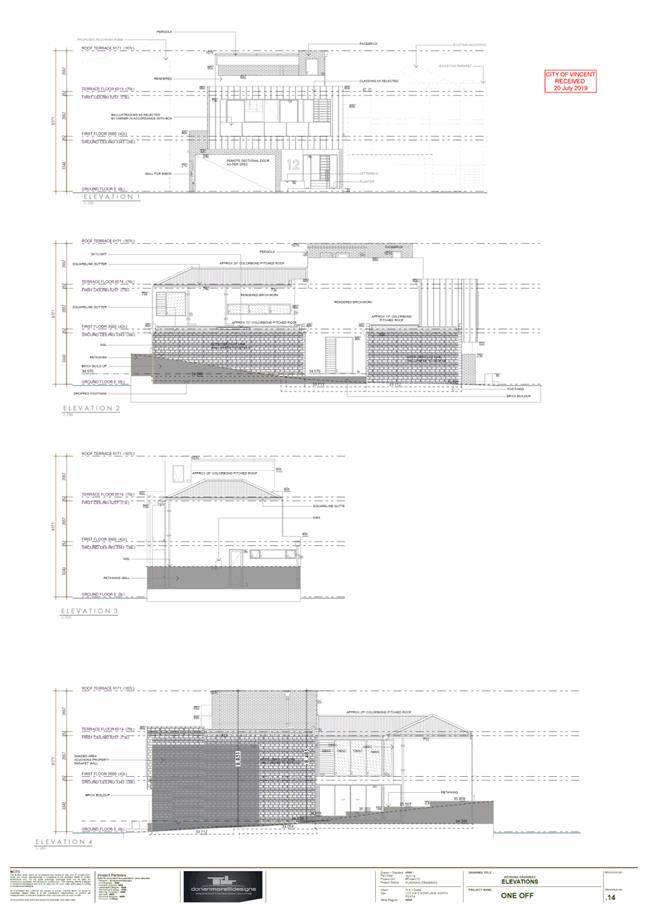
· The third storey component of the dwelling is located centrally, and stepped away from the parapet wall to the ground and first floor of the dwelling. The stepped approach reduces the vertical massing of the eastern elevation and alleviates the visual impact of the third storey element of the proposal to the abutting eastern property.
· The eastern elevation incorporates white render, facebrick detailing and a contrasting grey Colorbond roof to ameliorate the actual and perceived bulk of the roof terrace and third storey element. The large glazed openings on the ground floor and the obscured openings to the kitchen and dining on the first floor presents as an open and interactive elevation void of blank solid walls, further assisting reducing the bulk and scale impacts to the eastern lot boundary.
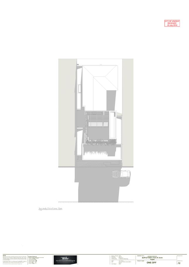
· The favourable orientation of the site results in no overshadowing and subsequent loss of direct sunlight to the adjacent dwellings.
· The development does not result in any departures from the deemed-to-comply visual privacy requirements of the R Codes in relation to visual privacy for the adjacent property.
· The departure to the lot boundary setback is considered very minor in nature and does not impact on the adjacent neighbouring properties in terms of bulk and scale given the scale of the terrace element.
· Landscaping via canopy and deep soil areas, is incorporated to the roof terrace of the property which helps to soften the building edge when viewed from adjacent properties and Nova Lane.
Lot Boundary Walls
The application proposes boundary walls to two side boundaries of the lot. The deemed-to-comply provisions permits a boundary wall length of 15.2 metres for the subject lot with an average height of 3 metres and a maximum height of 3.5 metres.
The following boundary walls are proposed:
Western Boundary
The proposal incorporates two sections of boundary wall on the western boundary that are 16.1 metres in lieu of the deemed-to-comply 15.2 metres. The first portion of boundary wall being the garage proposes departures to the average wall height of 3.8 metres in lieu of the deemed-to-comply 3.0 metre average wall height, and a 3.9-metre maximum wall height in lieu of the deemed-to-comply 3.5 metres. The second portion of the boundary wall bed 2 to bed 3 seeks variations to the maximum wall height 3.6 metres in lieu of the 3.5 metres.
The lot boundary walls proposed satisfy the relevant design principles and local housing objectives of the R Codes and Built Form Policy and are acceptable for the following reasons:
· The proposed boundary wall is located behind the street setback line of the dwelling, with a large concentration of the boundary bulk located to the rear of the site, not visible from the street. The boundary walls are of a single storey nature and do not generate or exacerbate mass from the street or adjacent properties.
· The proposed walls located on the western boundary do not compromise access to direct sunlight for the subject dwelling and do not adversely impact adjoining properties with respect to overshadowing
· The boundary wall does not incorporate major openings and would not result in overlooking to the adjoining site.
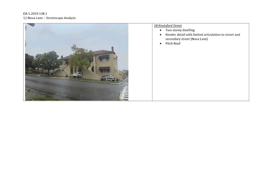
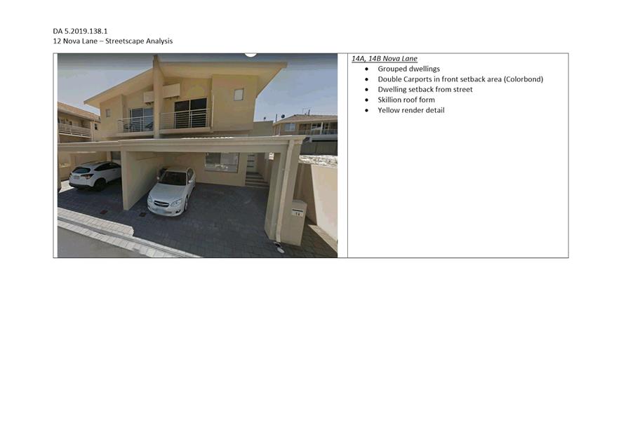
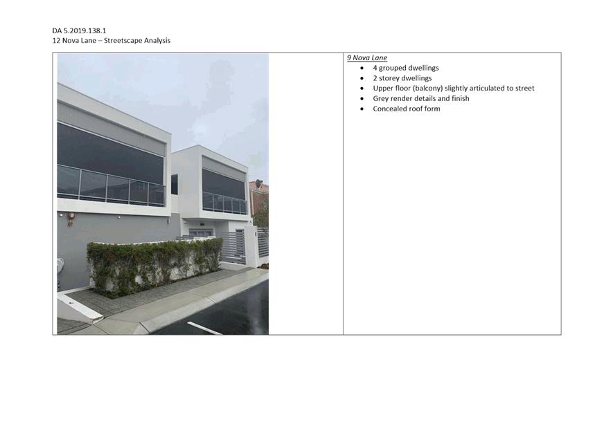
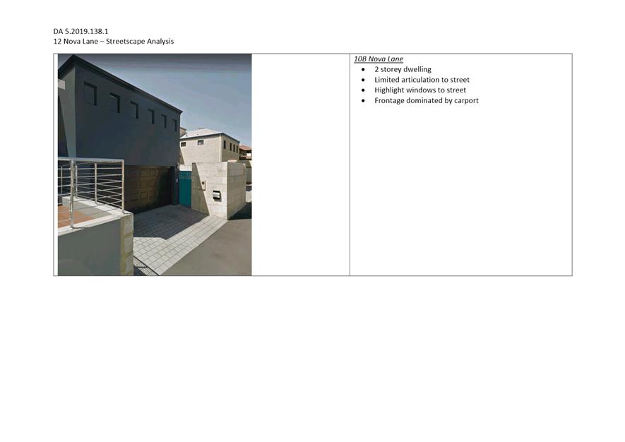
· Two storey boundary walls are a prevalent built form outcome within the Nova Lane established streetscape. The scale and materials of the boundary walls – face brick and render finish are consistent with colours and materials of other dwellings within the established street. As visible from the streetscape analysis in Attachment 3.
· The remainder of the dwelling is articulated and incorporates varying materials, to reduce the bulk of the development to the adjacent property.
Eastern boundary
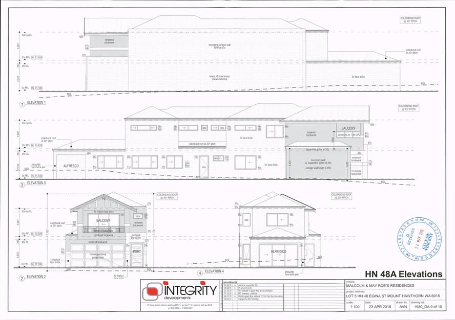
The application proposes a 9.9 metre lot boundary wall with a maximum height of 6.9 metres and an average maximum height of 6.6 metres in lieu of the deemed to comply 3.5 metres and 3 metres respectively.
The lot boundary walls proposed satisfy the relevant design principles and local housing objectives of the R Codes and Built Form Policy and are acceptable for the following reasons:
· The two storey boundary wall is setback 3 metres from the ROW on the eastern boundary and abuts a boundary wall on No. 10A Nova Lane which is setback 2 metres from the ROW is 6.9 metres in length and 4 metres in height.
· The proposed boundary wall would largely screen the existing blank boundary wall at No. 10A Nova Lane with the proposed wall reducing the impact of bulk on the streetscape and providing a better amenity outcome for the occupants of proposed dwelling.
· The boundary wall extends 3.3 metres longer than the abutting existing parapet wall of No. 10A Nova Lane. The additional length abuts a paved access leg along the boundary of the property with a swimming pool located adjacent to the access leg. The proposed boundary wall does not incorporate any major openings and would not disrupt or diminish the amenity of the neighbouring property.
· The proposed boundary when viewed from the street would largely be obscured by the existing double storey dwelling with a boundary wall at No. 10A Nova Lane.
· The proposed boundary wall is proposed to be constructed of a facebrick material, consistent with built form outcomes of the Nova Lane streetscape, and blends in well with the brick finish of the existing boundary wall.
· The development meets the solar access deemed-to-comply requirements.
· The remainder of the eastern boundary incorporates a large number of obscured openings which reduces the scale of blank and solid walls to adjacent properties.
Building Height
The application proposes a height of three storeys with a maximum height of 9.0 metres to the top of the concealed roof in lieu of the two storey and maximum concealed roof height of 7.0 metres set as a deemed‑to‑comply standard in the City’s Built Form Policy.
The building height departure relates only to the centrally located stairwell on the third floor of the dwelling. The building height proposed satisfies the relevant design principles and local housing objectives of the R Codes and Built Form Policy and is acceptable for the following reasons:
· The third storey and maximum height of 9 metres relates only to the centrally located stairwell roof, which provides access to the roof terrace.
· The central location of the stairwell means that the portion of the stairwell roof is largely not visible from neighbouring properties or adjacent Nova Lane and does not result in additional bulk to the development.
· The third storey element of the dwelling is setback 5.2 metres from Nova Lane, resulting in a built form that is generally not visible from the street.
· Screening to the western side of the third storey roof terrace area ensures that development meets the visual privacy deemed-to-comply aspects of the proposal. This screening provides a level of privacy and amenity to the subject site, as well as the neighbouring properties.
· The slope of the lot from north to south (front to rear) means the proposed dwelling to the rear sits lower than the retained dwelling and does not impact on the established character of the Mabel Street streetscape.
· The central location of the stairwell means that this third storey does not result in additional overshadowing of adjoining properties. The overshadowing proposed meets the deemed-to-comply standards of the R Codes.
· The finished floor levels proposed have been stepped in line with the natural ground levels of the site, to ensure a reduced overall height for the building. The development considers and responds to the natural slope with minimal fill and excavation required.
Setback of Garages and Carports
The application proposes a garage 300 millimetres (0.3 metres) set forward of the main building line of the dwelling in lieu of 500mm (0.5 metres) setback behind the main dwelling line, as per the deemed-to-comply requirements of the Built Form Policy.
The proposed garage setback is considered to satisfy the relevant design principles and local housing objectives of the R Codes and Built Form Policy and is considered acceptable for the following reasons:
· The proposal meets the deemed-to-comply requirements in regards to sight lines, and the projection of the garage forward of the main building line does not obscure views.
· The dwelling provides a clear delineation and visibility of the entrance to the dwelling, which is considered to mitigate the impacts of the garage.
· The façade of the dwelling incorporates mixed materials – cladding, render and facebrick – as well as articulations to break up the scale and bulk of the proposal.
· The garage does not obstruct views of dwellings from the street and vice versa.
· Carports and garages forward of the main dwelling is a common built form outcome to the adjacent properties. As a result the minor projection of the garage is not considered to exacerbate the built form outcome and its presentation to the street.
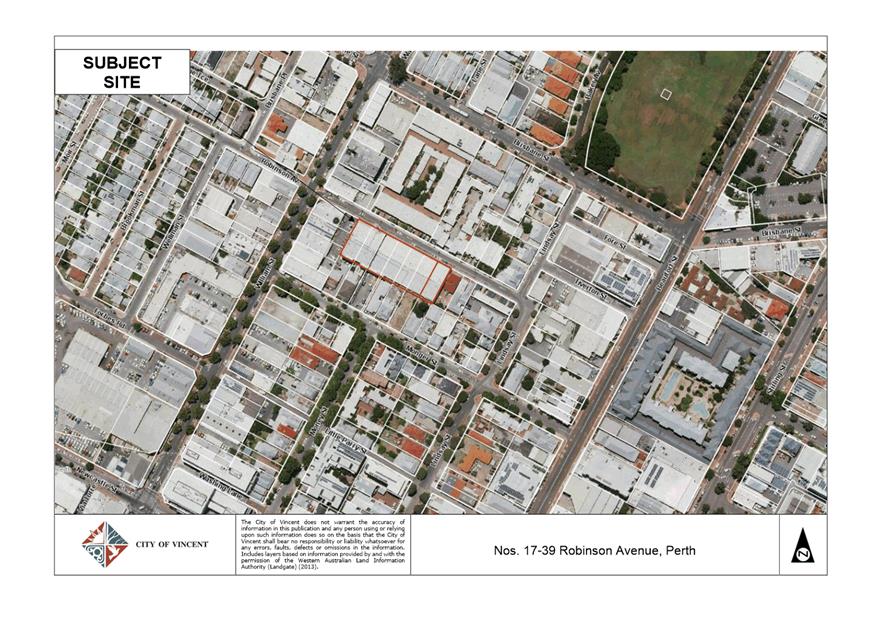
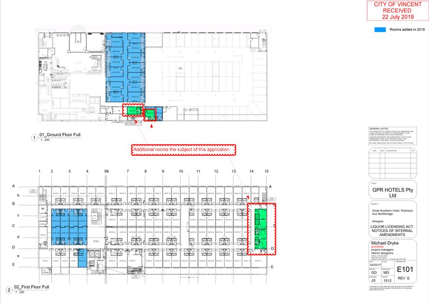
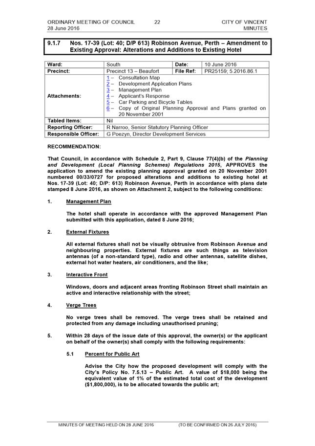
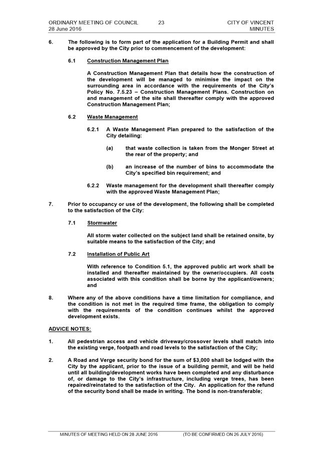
5.3 Nos. 17-39 (Lot: 38-44; D/P: 613) Robinson Avenue, Perth - Alterations and Additions to Hotel (Amendment to Approved - Unauthorised Existing Development)
TRIM Ref: D19/104296
Author: Mitchell Hoad, Senior Urban Planner
Authoriser: Joslin Colli, Coordinator Planning Services
Ward: South
Attachments: 1. Location
Map ⇩ ![]()
2. Development Plans
⇩ ![]()
3. Minutes of the 28
June 2016 Council Meeting ⇩ ![]()
4. Determination
Advice Notes ⇩ ![]()
|
That Council, in accordance with the provisions of the City of Vincent Local Planning Scheme No. 2 and the Metropolitan Region Scheme, APPROVES the application for Alterations and Additions to Hotel (Amendment to Approved - Unauthorised Existing Development) at Nos. 17-39 (Lot: 38-44; D/P: 613) Robinson Avenue, Perth, in accordance with the plans shown in Attachment 2 dated 22 July 2019, subject to the following conditions and Advice Notes contained in Attachment 4: Conditions 1. This approval is for Alterations and Additions to Hotel (Amendment to Approved – Unauthorised Existing Development) as shown on the plans dated 22 July 2019. No other development forms part of this approval; and 2. All conditions and advice notes detailed on development approval 5.2016.86.1 granted on 28 June 2016 continue to apply to this approval. |
Purpose of Report:
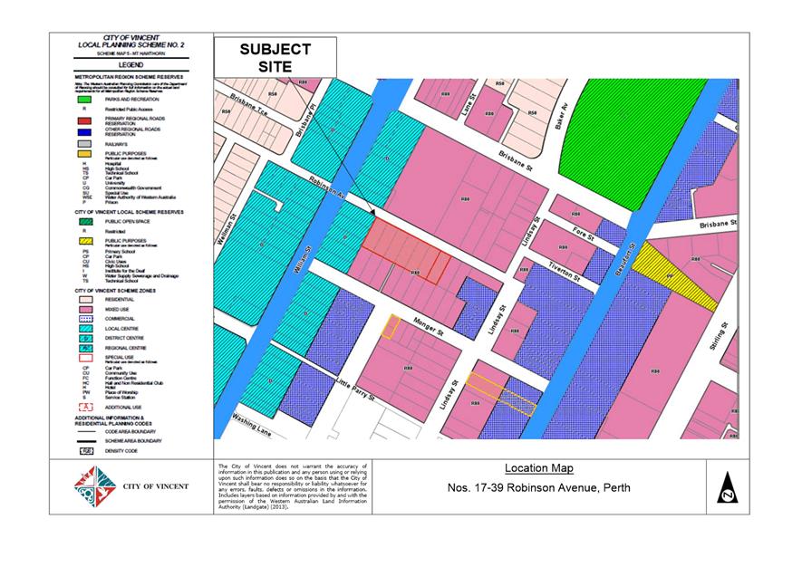
To consider an application for an amendment to a previous development approval for alterations and additions to a Hotel (unauthorised existing development) at Nos. 17-39 Robinson Avenue, Perth (the subject site). A location plan is included in Attachment 1.
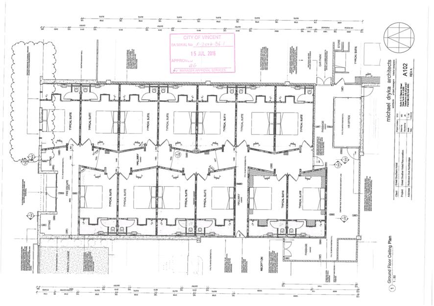
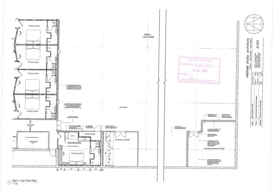
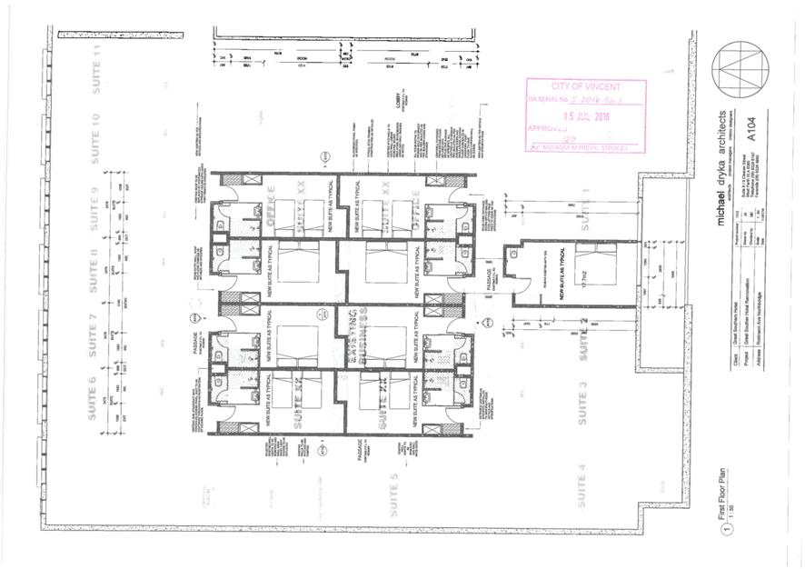
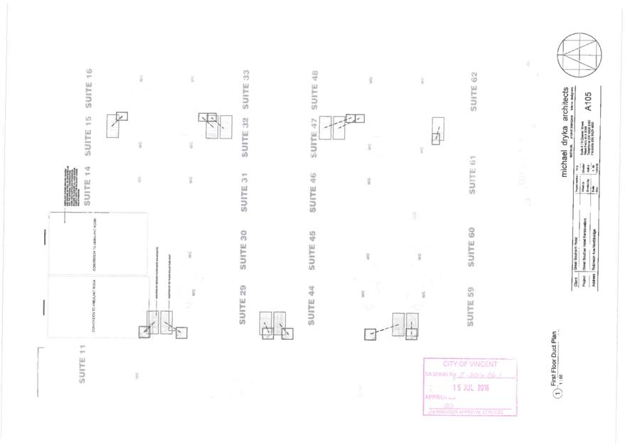
PROPOSAL:
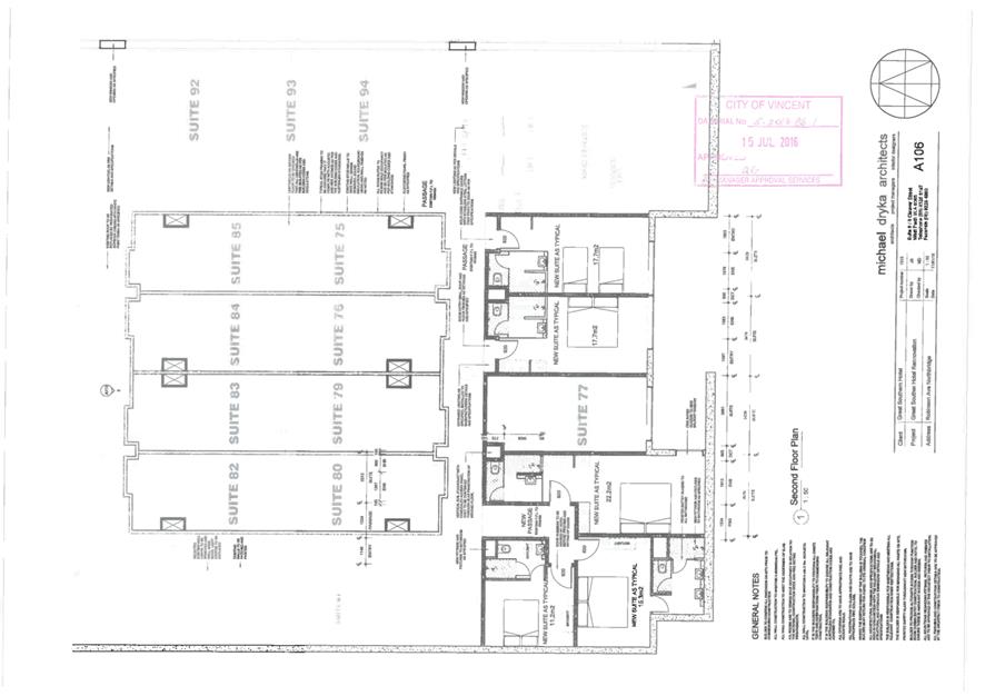
The application seeks approval for modifications to the existing Hotel to increase the number of rooms from 121 rooms to 127 rooms. The modifications to the Hotel to accommodate the additional six rooms includes:
· The conversion of the Night Manager room on the ground floor into one additional room (Suite 213);
· The conversion of a family suite on the ground floor into two separate rooms, resulting in one additional room (Suite 214); and
· The conversion of the Maids Room on the first floor into four additional rooms.
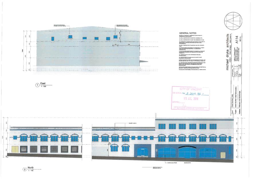
Plans of the development with the additional rooms indicated are included in Attachment 2. The modifications are internal only and do not result in any external changes to the existing façade of the Hotel.
Background:
|
Landowner: |
GPR Hotels Pty Ltd |
|
Applicant: |
Michael Dryka Architects |
|
Date of Application: |
26 June 2019 |
|
Zoning: |
MRS: Urban LPS2: Zone: Mixed Use R Code: R80 |
|
Built Form Area: |
Mixed Use |
|
Existing Land Use: |
Hotel |
|
Proposed Use Class: |
Hotel |
|
Lot Area: |
3,106m² |
|
Right of Way (ROW): |
No |
|
Heritage List: |
No |
The subject site is bound by Robinson Avenue to the north-east, single storey commercial development to the north-west, single and two-storey residential development to the south-west and two storey residential development to the south-east.
The subject site and surrounding land is zoned Mixed Use R80 under the City’s Local Planning Scheme No. 2 (LPS2) and is located within the Mixed Use built form area under the City’s Policy No. 7.1.1 – Built Form (Built Form Policy), with the exception of the land to the north-west. This land is zoned District Centre under LPS2 and is within the Town Centre built form area.
The subject site currently consists of the Great Southern Hotel, which is two to three-storeys in height and has 25 parking bays located on site. The Hotel was approved by Council at its Ordinary Meeting on 9 May 2001. The most recent amendment to the Hotel was approved by Council at its Ordinary Meeting on 28 June 2016. This approval increased the number of rooms from 94 rooms to 121 rooms, and included some modifications to the external façade. The Minutes from this Ordinary Council Meeting, including a copy of the determination notice and plans, are included in Attachment 3.
The applicant submitted a request for a Section 40 Certificate of land use approval which is required by the Department of Racing Gaming and Liquor to accompany a Liquor License application. This request included plans which proposed to increase the licensed area from 94 rooms to 127 as shown in the plans in Attachment 2. Administration advised the applicant that approval only exists for 121 rooms on the subject site in accordance with the previous determination by Council, and an amended development application seeking approval for the additional rooms was required to be submitted. Should the development application be approved, the applicant would also be required to submit an application for a retrospective Occupancy Permit with the City for the unauthorised works.
Details:
Summary Assessment
The table below summarises the planning assessment of the proposal against the provisions of the LPS2, Built Form Policy and the City’s policies. In each instance where the proposal requires the discretion of Council, the relevant planning element is discussed in the Detailed Assessment section following from this table.
|
Planning Element |
Use Permissibility/ Deemed-to-Comply |
Previously approved |
Requires further Discretion |
|
Land Use (only where required) |
|
ü |
|
|
Car Parking |
ü |
|
|
Consultation/Advertising:
Community Consultation was undertaken by the City for a period of 14 days in accordance with the Planning and Development (Local Planning Schemes) Regulations 2015 from 18 July 2019 to 1 August 2019. The method of advertising included a sign being erected on-site, a newspaper advertisement and a notice on the City’s website in accordance with the City’s Policy No. 4.1.5 – Community Consultation.
At the conclusion of the consultation period, no submissions were received.
Design Review Panel (DRP):
Referred to DRP: No
Legal/Policy:
· Planning and Development Act 2005;
· Planning and Development (Local Planning Schemes) Regulations 2015;
· City of Vincent Local Planning Scheme No. 2;
· Policy No. 4.1.5 – Community Consultation; and
· Policy No. 7.7.1 – Non-Residential Development Parking Requirements.
The application to amend an approval can be considered in accordance with Schedule 2, Clause 77(1) (a) of the Planning and Development (Local Planning Schemes) Regulations 2015. Clause 77(2) (b) allows the application to be made during or after the period within which the development must be substantially commenced. Clause 77(4) provides the local government the ability to approve the application with or without conditions or refuse the application.
Delegation to Determine Applications:
This matter has been referred to Council in accordance with the City’s Delegated Authority Register as the application is an amendment to a development approval that was determined by Council.
Risk Management Implications:
There are minimal risks to Council and the City’s business function when Council exercises its discretionary power to determine a planning application.
Strategic Implications:
This is in keeping with the City’s Strategic Community Plan 2018-2028:
Innovative and Accountable
We are open and accountable to an engaged community.
SUSTAINABILITY IMPLICATIONS:
Nil.
Financial/Budget Implications:
Nil.
Comments:
The application for alterations and additions to the existing Hotel proposes the conversion of existing internal spaces to create an additional six rooms. This increases the total number of rooms from 121 previously approved by Council at its Ordinary Meeting on 28 June 2016 to 127. The proposal does not result in any external changes or increase to the existing building footprint. There are no exemptions for this type of development.
The existing Hotel currently has 25 on-site parking bays. The most recent application approved by Council in 2016 required 21.08 bays, resulting in a surplus of 3.95 bays. Under the current Policy No. 7.7.1 – Non‑Residential Development Parking Requirements (Parking Policy), the subject application requires three parking bays for the six additional rooms proposed, at a rate of 0.5 bays per room. This results in a surplus of 0.95 parking bays on the subject site.
As a result of there being no external changes to the existing building and car parking satisfying the requirements of the Parking Policy, the proposal will not have any impact on the surrounding area. The proposal will continue to contribute towards the supply of tourist accommodation within Perth. It is recommended that Council approves this development application.
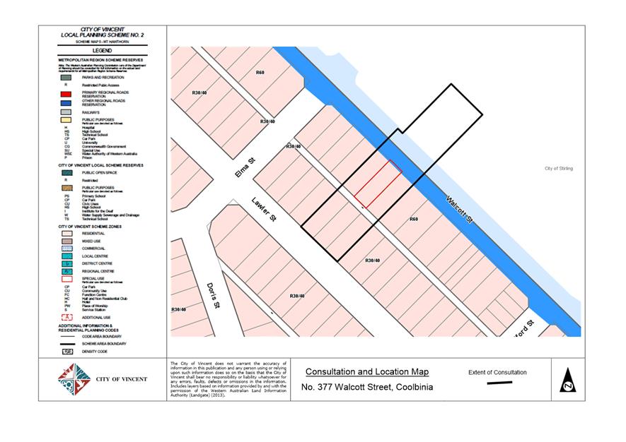
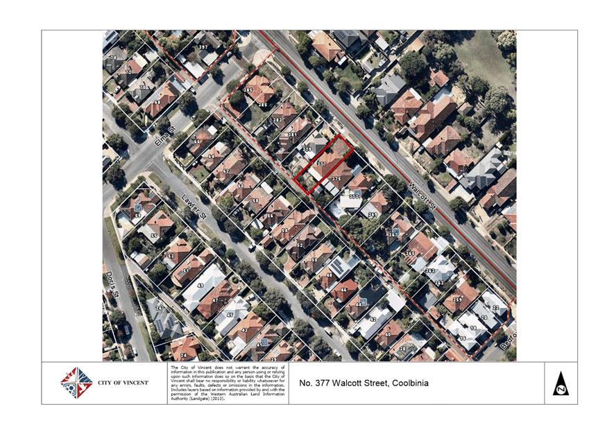
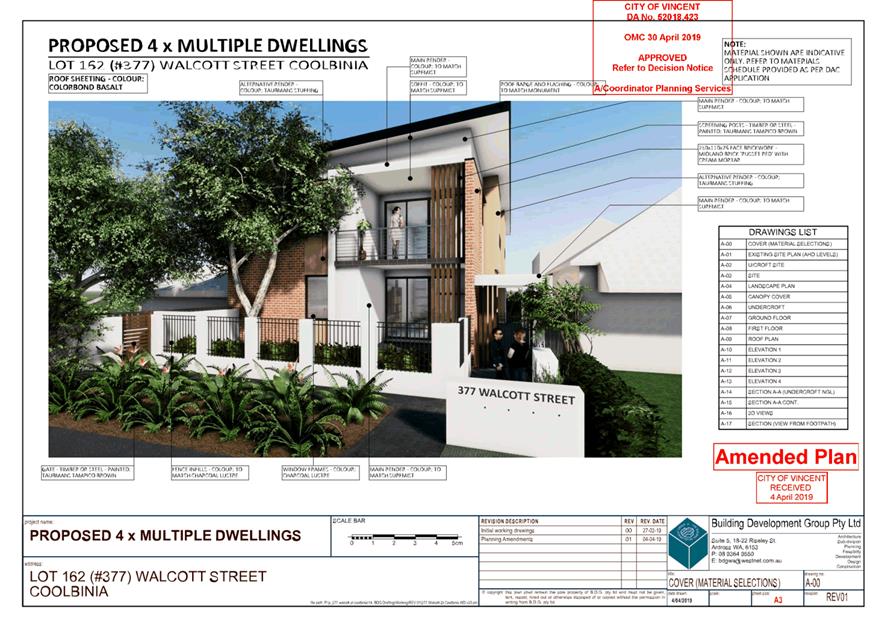
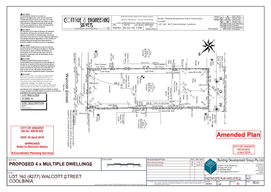
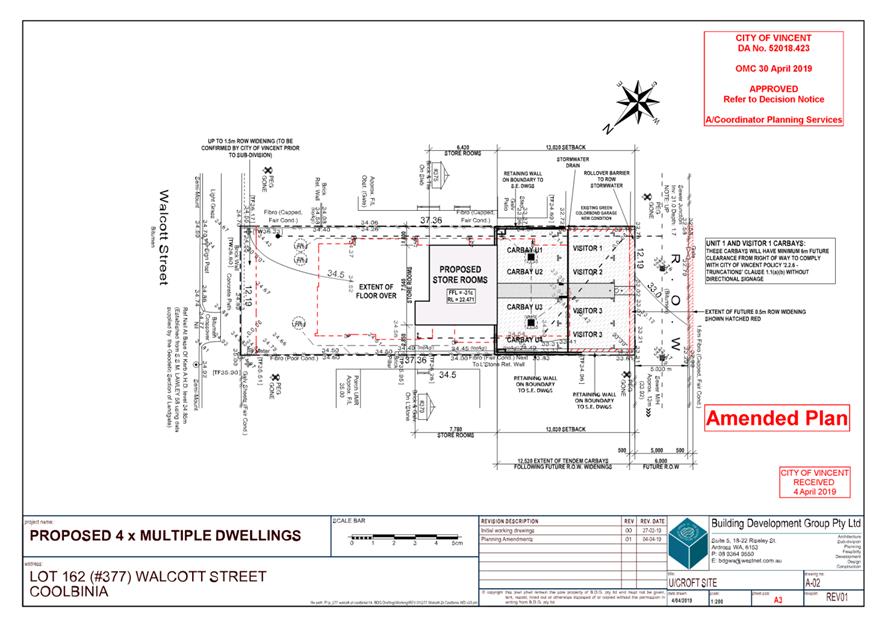
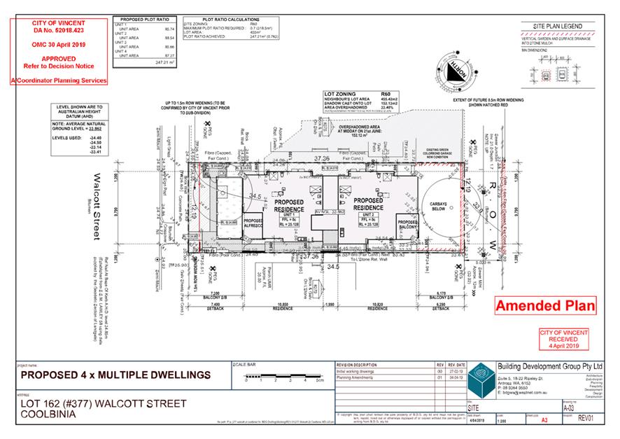
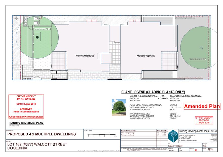
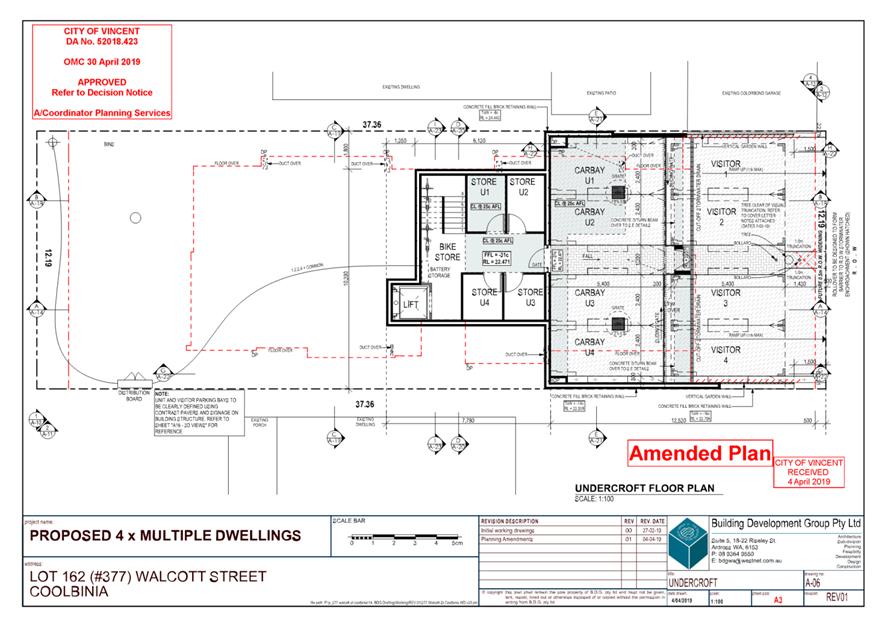
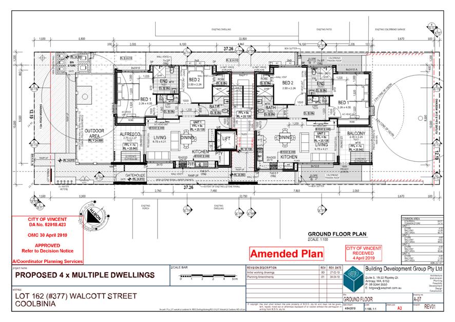
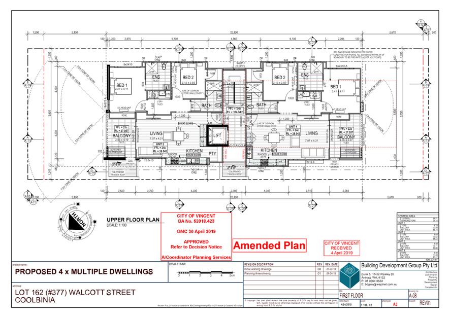
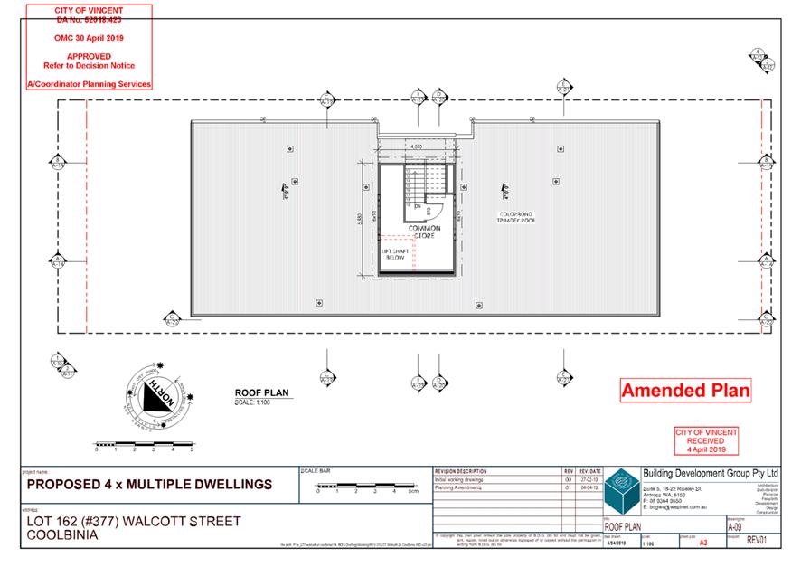
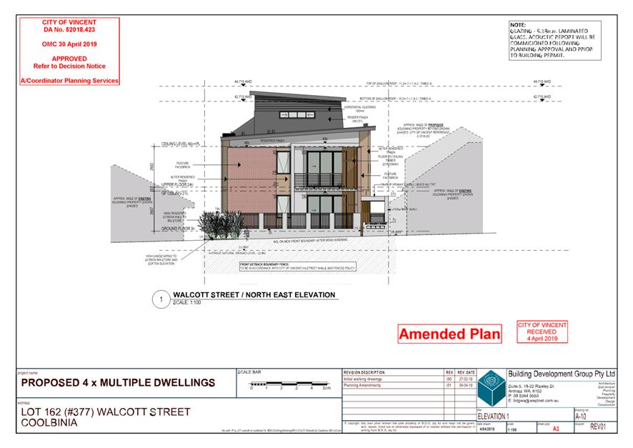
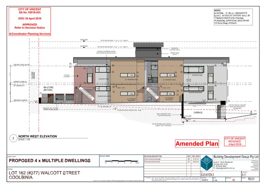
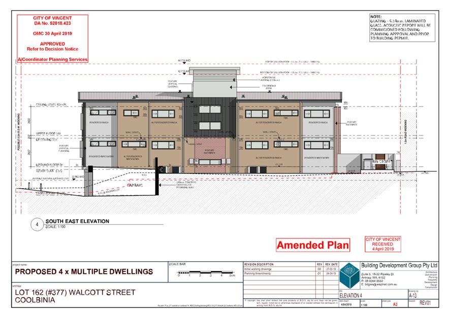
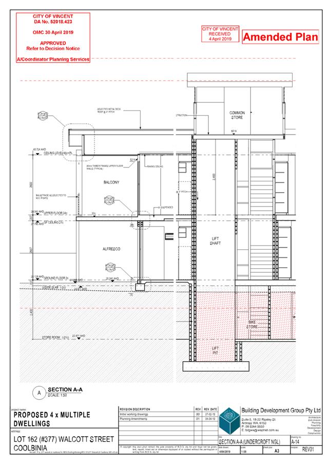
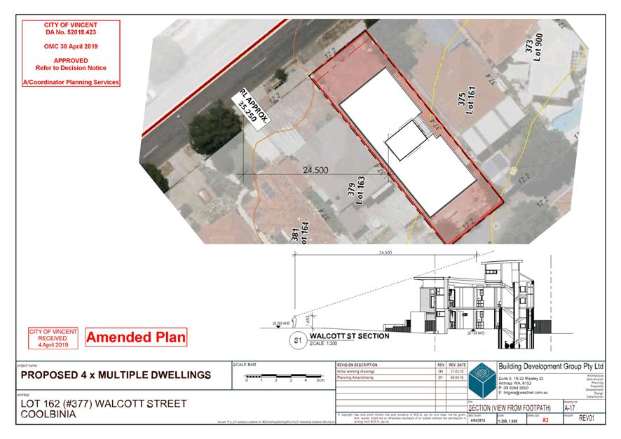
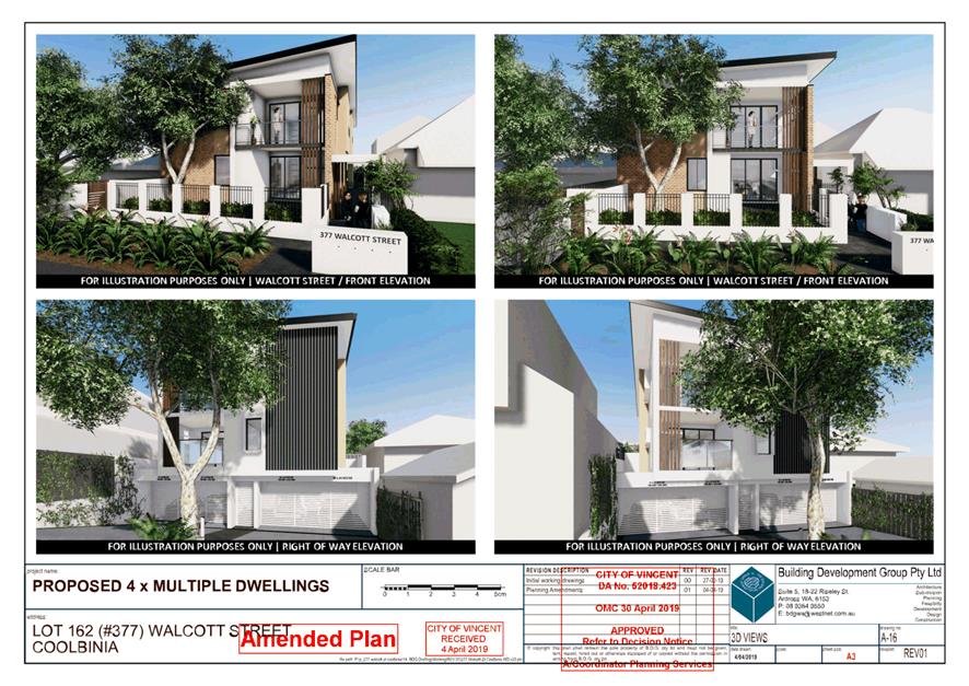
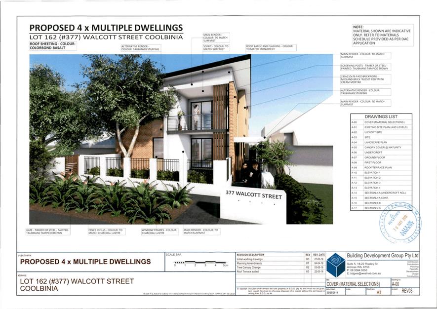
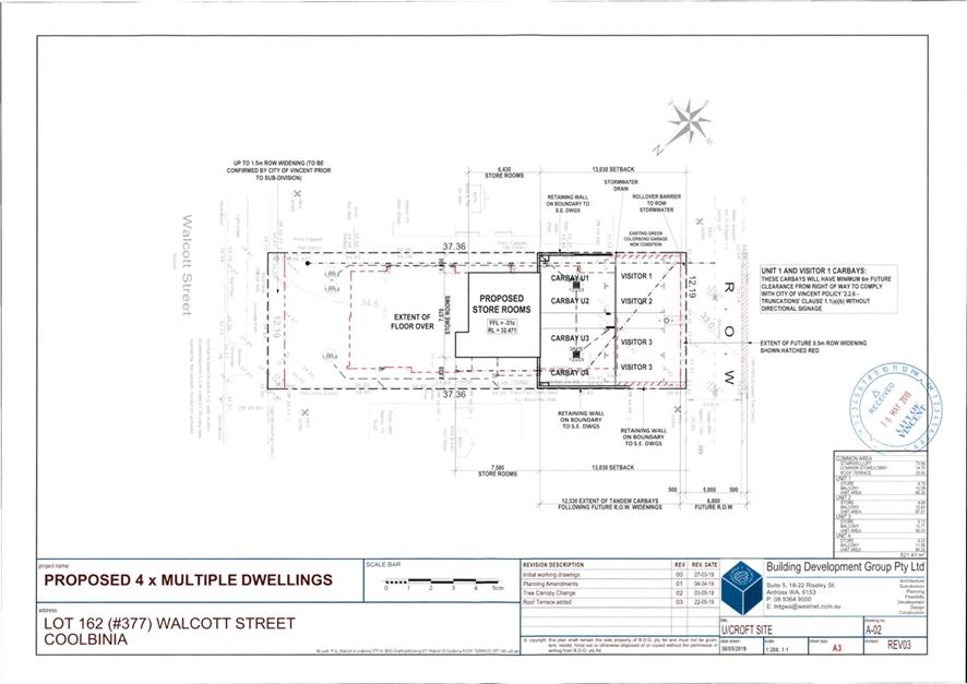
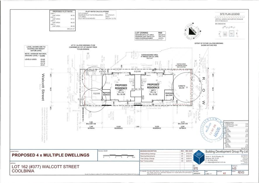
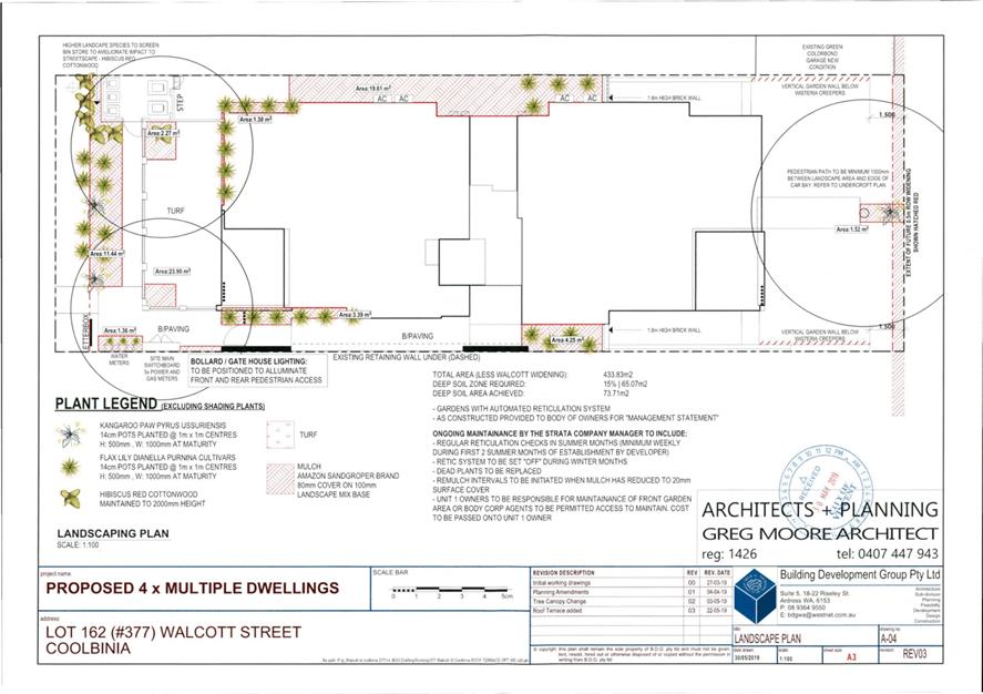
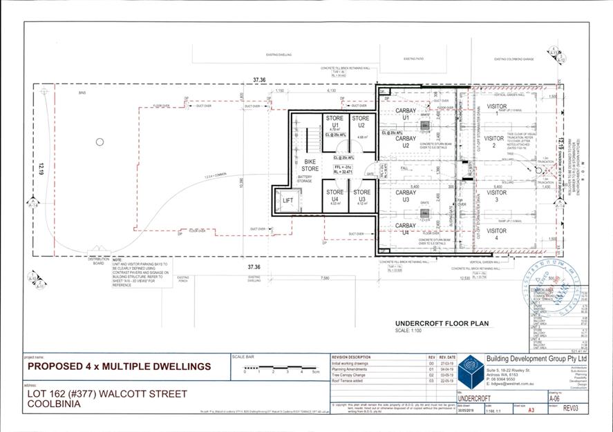
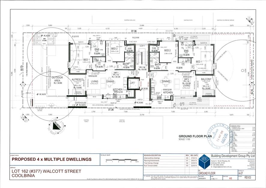
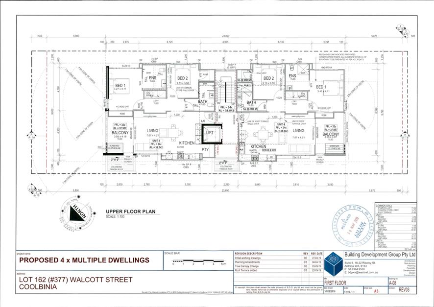
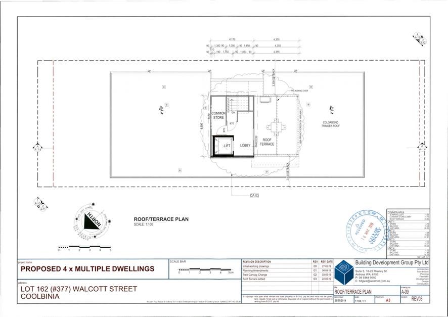
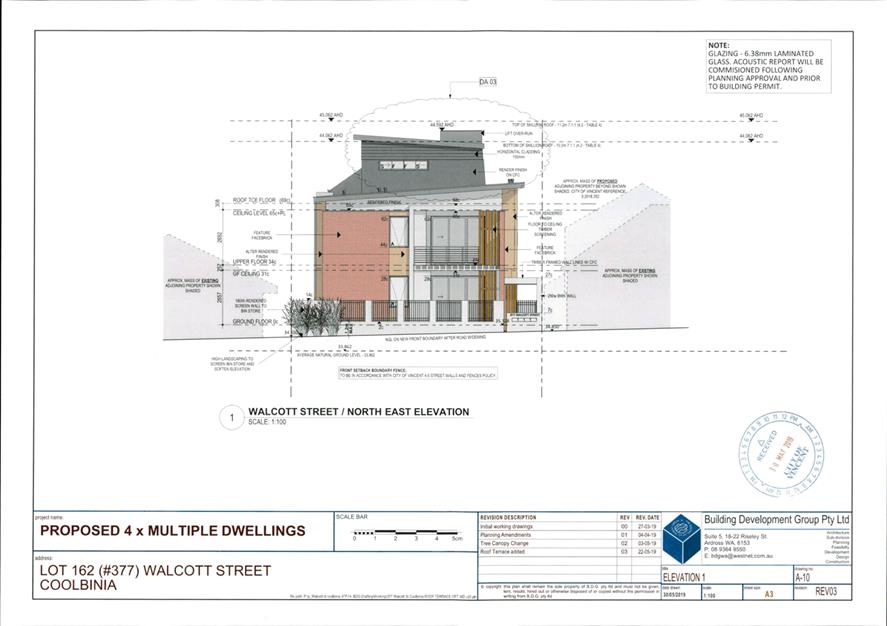
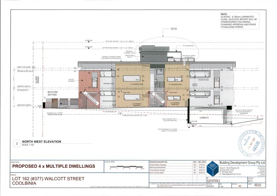
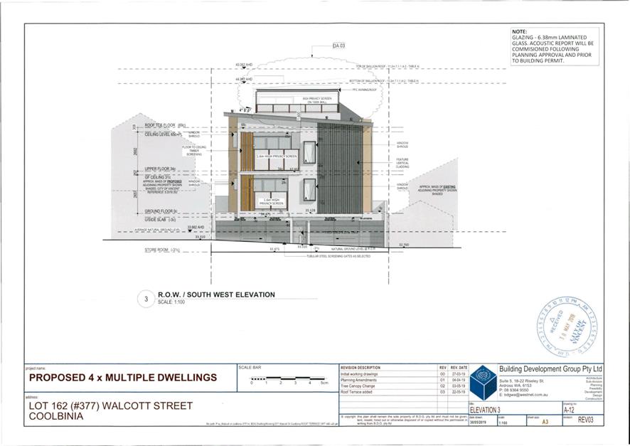
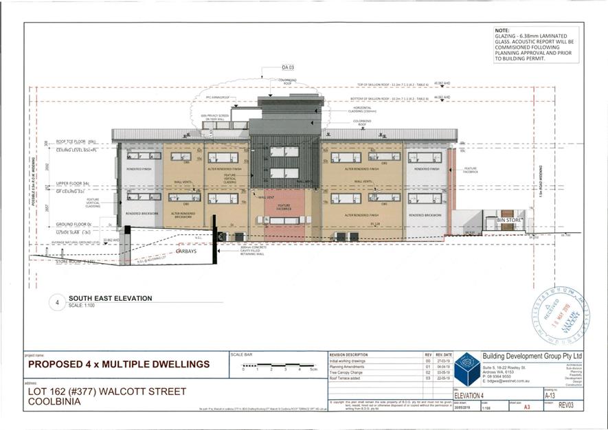
5.4 No. 377 (Lot: 162; D/P: 2630) Walcott Street, Coolbinia - Proposed Four Multiple Dwellings (Amendment to Approved)
TRIM Ref: D19/100058
Author: Dan McCluggage, Urban Planner
Authoriser: Joslin Colli, Coordinator Planning Services
Ward: North
Attachments: 1. Location
and Consultation Plan ⇩ ![]()
2. Previously
Approved Development Plans ⇩ ![]()
3. Minutes of 30
April 2019 Council Meeting ⇩ ![]()
4. Proposed
Development Plans ⇩ ![]()
5. Summary of Submissions
- Administration's Comments ⇩ ![]()
6. Summary of
Submissions - Applicant's Response ⇩ ![]()
|
That Council, in accordance with the provisions of the City of Vincent Local Planning Scheme No. 2 and the Metropolitan Region Scheme, APPROVES the application to amend a development approval for Four Multiple Dwellings at No. 377 (Lot: 162; D/P: 2630) Walcott Street, Coolbinia, in accordance with the plans shown in Attachment 4 dated 30 May 2019, subject to the following conditions: 1. All conditions and advice notes detailed on the development approval 5.2018.423.1 granted on 30 April 2019 continue to apply to this approval. |
Purpose of Report:
To consider an application for development approval for an amendment to the previous approval for four Multiple Dwellings at No. 377 Walcott Street, Coolbinia (subject site).
PROPOSAL:
Council at its Ordinary Council Meeting 30 April 2019, approved a development application for four Multiple Dwellings subject to conditions at the subject site. The development plans approved by Council are included as Attachment 2.
The current application proposes to make the following amendments to the previously approved development plans:
· A communal roof terrace area has been added. This roof terrace would be universally accessible from the lift and provided with a 1.6 metre high privacy screen on all sides;
· The lift roof height has been increased from 10.1 metres to 10.5 metres to cater for the lift head mechanical access. The proposed building height remains compliant with the 11.2 metre deemed‑to‑comply standards of the City’s Policy No. 7.1.1 – Built Form (Built Form Policy);
· The setback of the lift wall to the north western lot boundary has been reduced by 0.2 metres;
· The ground floor Unit 1 and upper floor Unit 4 kitchen wall lengths have been reduced by 0.2 metres;
· Two windows on the north western elevation have increased in size. These windows remain obscured and fixed and would not result in any departures from visual privacy standards; and
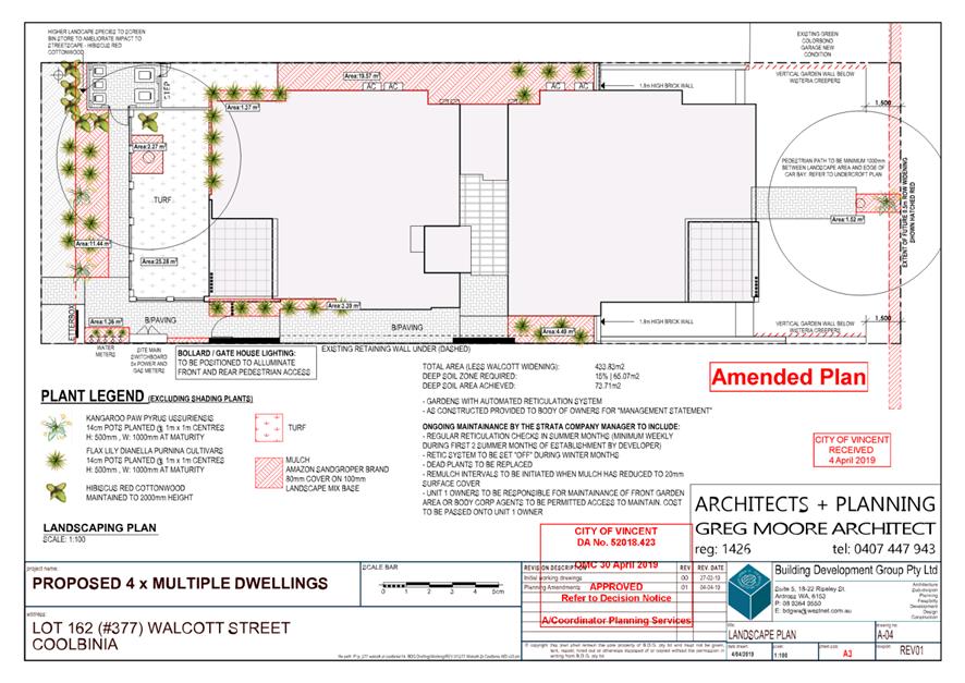
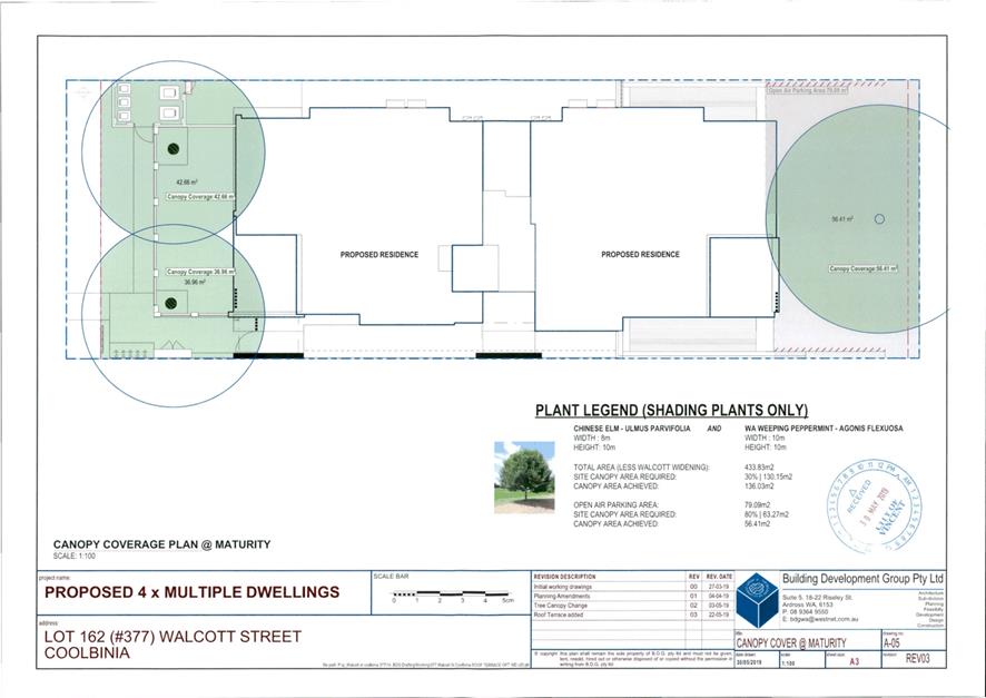
· One additional tree has been added to unit 1 and the proposed tree species has been changed from Bradford Pear to WA Weeping Peppermint in order to satisfy Condition 2 of the previous development approval.
The proposed development plans are included as Attachment 4.
Background:
|
Landowner: |
Building Development Group Pty Ltd |
|
Applicant: |
Building Development Group Pty Ltd |
|
Date of Application: |
30 May 2019 |
|
Zoning: |
MRS: Urban/Other Regional Roads LPS2: Zone: Residential R Code: R60 |
|
Built Form Area: |
Transit Corridor |
|
Existing Land Use: |
Single House |
|
Proposed Use Class: |
Multiple Dwellings |
|
Lot Area: |
455m² |
|
Right of Way (ROW): |
Yes, 5.0 metres wide, drained and sealed |
|
Heritage List: |
No |
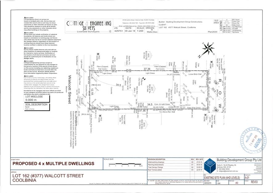
The subject site is located at No. 377 Walcott Street, Coolbinia, as shown on the location plan included as Attachment 1. There is an existing Single House on the subject site.
The subject site has frontages to Walcott Street to the north-east and a right of way (ROW) to the southwest. The site is adjoining a Single House to the south-east and a Single House to the north-west. The property to the north-west has a current development approval for the construction of a two-storey Grouped Dwelling. The broader area is generally characterised by single storey Single Dwellings.
The subject site is zoned Residential with a density coding of R60 under the City’s Local Planning Scheme No. 2 (LPS2). The subject site and adjoining properties along Walcott Street are within the Transit Corridor built form area under the City’s Policy No. 7.1.1 – Built Form (Built Form Policy). Walcott Street is reserved as an Other Regional Road (ORR) under the Metropolitan Region Scheme (MRS). The subject site is affected by 1.5 metres of road widening to Walcott Street as per the Department of Planning, Lands and Heritage (DPLH) Land Requirement Plan. The subject site is also subject to the City’s requirement for 0.5 metres of ROW widening.
Details:
Summary Assessment
The previous development application was assessed against the standards of the City’s Built Form Policy and Part 6 of State Planning Policy 3.1: Residential Design Codes (R Codes). The previous development application was approved with departures to the plot ratio, lot boundary setbacks and sight line standards set our under Part 6 of State Planning Policy 3.1 Residential Design Codes.
On 18 February 2019, the Western Australian Planning Commission (WAPC) released the documentation for Design WA including State Planning Policy 7.3 Residential Design Codes Volume 2 - Apartments (R Codes Volume 2 - Apartments) which replaced Part 6 of the former R Codes on 24 May 2019. Whilst the R Codes Volume 2 - Apartments did not come into effect until after the previous approval was granted on 30 April 2019, this policy was given due regard during the assessment of the previously approved plans in accordance with clause 67(b) of the deemed provisions of the Planning and Development (Local Planning Schemes) Regulations 2015.
Consideration of Element Objectives and Acceptable Outcomes
The R Codes Volume 2 – Apartments includes Element Objectives and Acceptable Outcomes for each design element. Proposals are required to demonstrate that the design achieves the Element Objectives for each design element. While addressing the Acceptable Outcomes is likely to achieve the relevant Element Objectives, they are not a deemed-to-comply pathway and the proposal is still to be assessed against the relevant Element Objectives. Where Acceptable Outcomes are not met, proposals may still satisfy the Element Objective via alternative means or solutions.
The Element Objectives and/or Acceptable Outcomes that are not achieved in the proposal are as follows:
|
Lot Boundary Setback |
|
|
Acceptable Outcome |
Proposal |
|
R Codes Volume 2 – Clause 2.4 Side and Rear Setbacks
A 2.4.1 Minimum Side Setback – 3.0m |
Previously Approved · Proposed roof common store/lift wall minimum setback of 3.0m to the north western lot boundary.
Proposed · Proposed roof common store/lift wall minimum setback of 2.8m to the north western lot boundary. |
An assessment of how the proposal meets the Element Objectives of the R Codes Volume 2 – Apartments is discussed in the Comments section below.
Consultation/Advertising:
Community consultation was undertaken in accordance with the Planning and Development (Local Planning Schemes) Regulations 2015, for a period of 14 days commencing on 09 July 2019 and concluding on 23 July 2019. The method of consultation being 11 letters mailed to all owners and occupiers immediately adjacent to the subject site (as shown in Attachment 1) and a notice on the City’s website, in accordance with the City’s Policy No. 4.1.5 – Community Consultation.
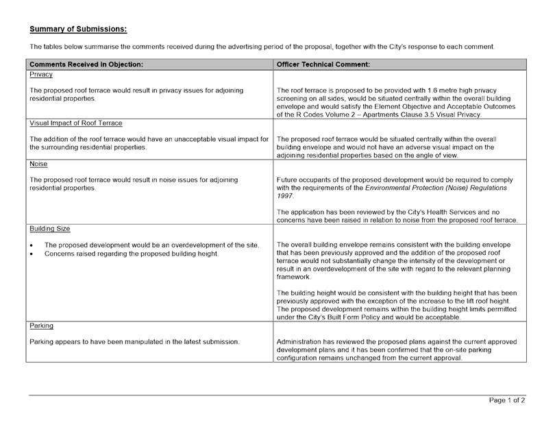
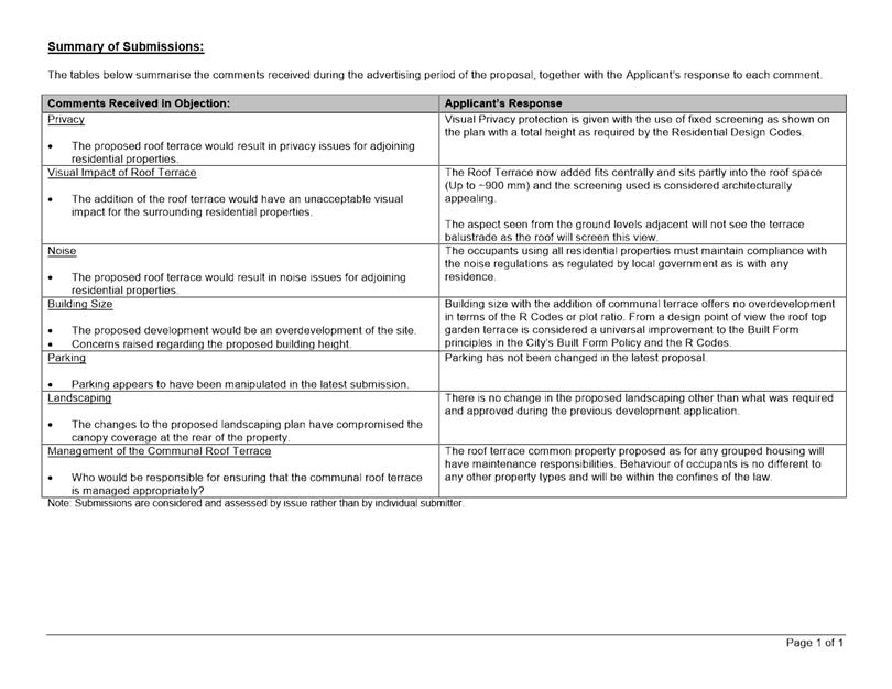
At the conclusion of the consultation period, a total of four submissions were received, all in objection to the proposal. The submissions received raised a number of objections relating to aspects of the development which were previously approved and are not proposed to be changed under the current application. The main objections raised in the submissions which were not addressed though the previous application relate to the following matters:
· The impact of the proposed roof terrace on the amenity of the adjoining properties with regard to visual privacy and noise;
· The visual impact of the proposed roof terrace;
· Overdevelopment and building size;
· Parking;
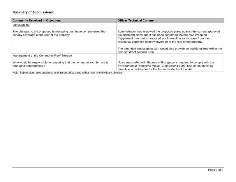
· Landscaping; and
· Management of the Communal Roof Terrace.
A summary of the submissions received and Administration’s comment is provided in Attachment 5. The applicant’s response to the summary of submissions is provided in Attachment 6.
Design Review Panel (DRP):
Referred to DRP: No
The previous application was referred to the DRP prior to lodgement and referred to the DRP Chairperson after lodgement. The current application was not referred to the DRP as the proposed changes to the previously approved plans would not result in a fundamental change to the building design.
Legal/Policy:
· Planning and Development Act 2005;
· Planning and Development (Local Planning Schemes) Regulations 2015;
· City of Vincent Local Planning Scheme No. 2;
· State Planning Policy 7.3 – Residential Design Codes Volume 2 - Apartments;
· Policy No. 4.1.5 – Community Consultation; and
· Policy No. 7.1.1 – Built Form Policy.
Should Council refuse the application for development approval, the applicant would have the right to have the decision reviewed in accordance with Part 14 of the Planning and Development Act 2005.
State Planning Policy 7.3 Residential Design Codes Volume 2 – Apartments (R Codes Volume 2 – Apartments
The R Codes Volume 2 – Apartments provides comprehensive guidance for the development of multiple dwellings and mixed use development and focuses on improved design outcomes for apartments that are responsive and appropriate to the context and character of the site and locality. This is a performance based assessment and applicants are required to demonstrate that the design achieves the objectives of each design element as well as the overall objectives of the R Codes Volume 2 – Apartments.
Delegation to Determine Applications:
This matter has been referred to Council in accordance with the City’s Delegated Authority Register as the application is an amendment to a development approval that was determined by Council.
Risk Management Implications:
There are minimal risks to Council and the City’s business function when Council exercises its discretionary power to determine a planning application.
Strategic Implications:
This is in keeping with the City’s Strategic Community Plan 2018-2028:
Innovative and Accountable
We are open and accountable to an engaged community.
SUSTAINABILITY IMPLICATIONS:
Nil.
Financial/Budget Implications:
Nil.
Comments:
Setback to the North Western Side Boundary
The previous application was approved with departures to the R Codes standards in relation to lot boundary setbacks to the north western and south eastern side boundaries. The Acceptable Outcomes of the R Codes Volume 2 – Apartments Clause 2.4 sets a minimum side setback of 3.0 metres.
The previous development approval plans provided a 3.0 metre minimum setback from the roof lift/lobby wall to the north western lot boundary. The current proposal would reduce the minimum setback of this wall from the north western lot boundary to 2.8 metres.
The proposed setbacks to the north western side boundary would be consistent with the Element Objectives of the R Codes Volume 2 – Apartments Clause 2.4 Side and Rear Setbacks and would remain acceptable for the following reasons:
· The proposed change to the minimum side setback would not result in a substantive change to the overall aesthetic or appearance of the development.
· The 2.8 metre setback of the lift/lobby wall to the north western lot boundary would still provide adequate separation between the development and the neighbouring property;
· The development would still provide adequate articulation in the building façade through stepping in sections of the building in order to reduce the overall bulk of the development as viewed from the adjoining property to the north west and from the street;
· The development would provide deep soil areas and canopy coverage in accordance with the City’s Built Form Policy; and
· The proposed roof/lobby wall would be setback 1.9 metres from the north western edge of the roof and would sit centrally within the overall building envelope.
TRIM Ref: D19/83695
Author: Natasha Trefry, Urban Planning Advisor
Authoriser: Jay Naidoo, Manager Development & Design
Ward: North
Attachments: 1. Consultation
and Location Map ⇩ ![]()
2. Development Plans
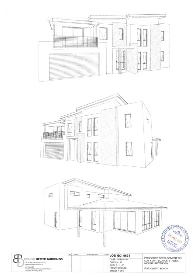
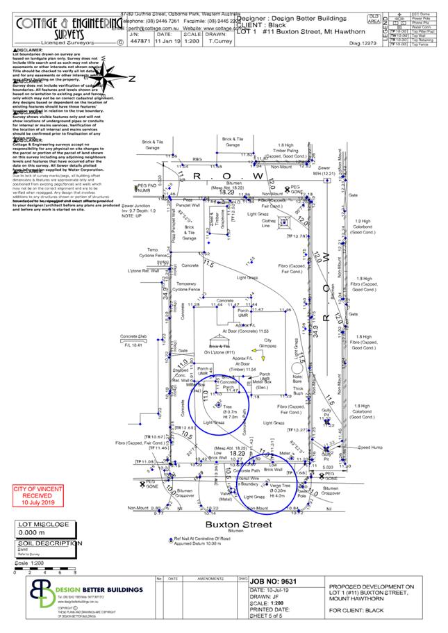
(received 19 March 2019) ⇩ ![]()
3. Development Plans
(received 10 July 2019) ⇩ ![]()
4. Development Plans
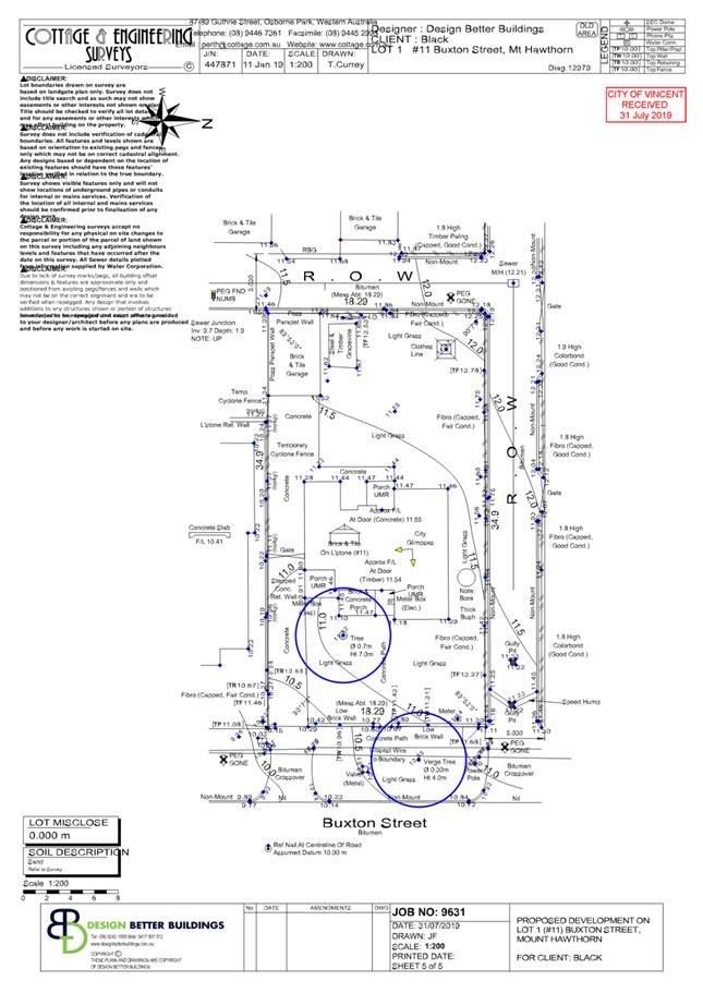
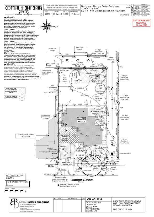
(received 31 July 2019) ⇩ ![]()
5. Summary of
Submissions - Administration's Response (Consultation 1) ⇩ ![]()
6. Justification
from Applicant ⇩ ![]()
7. Summary of
Submissions - Administrations Response (Consultation 2) ⇩ ![]()
8. Determination
Advice Notes ⇩ ![]()
|
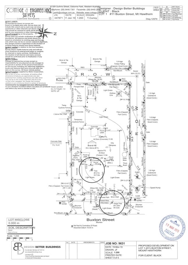
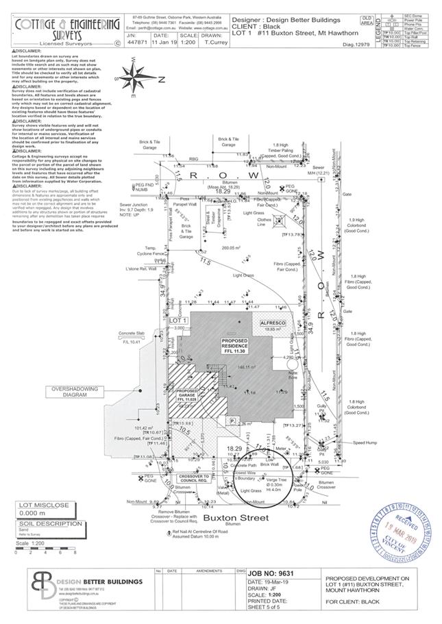
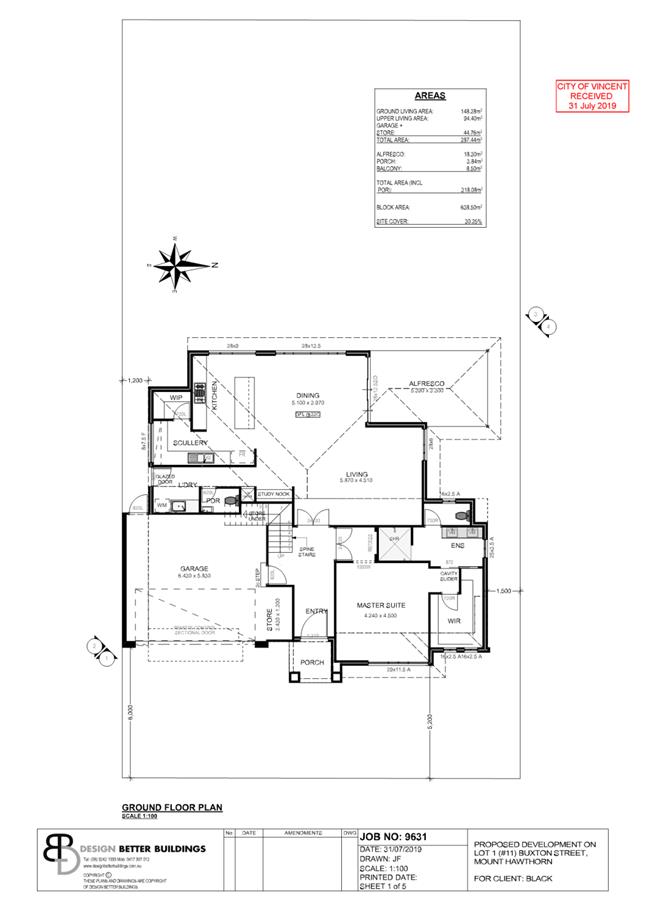
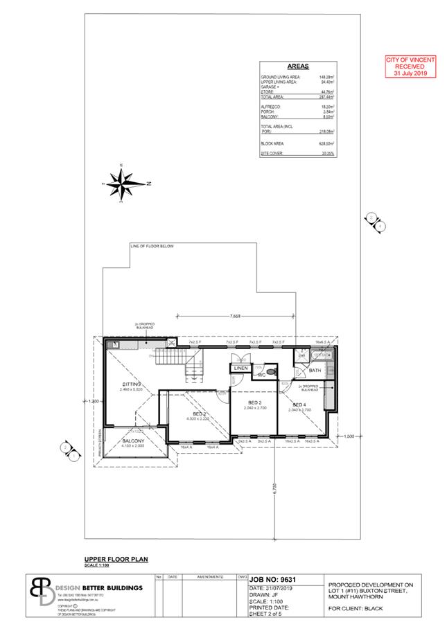
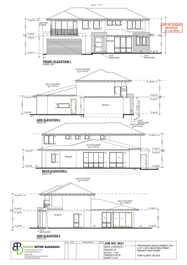
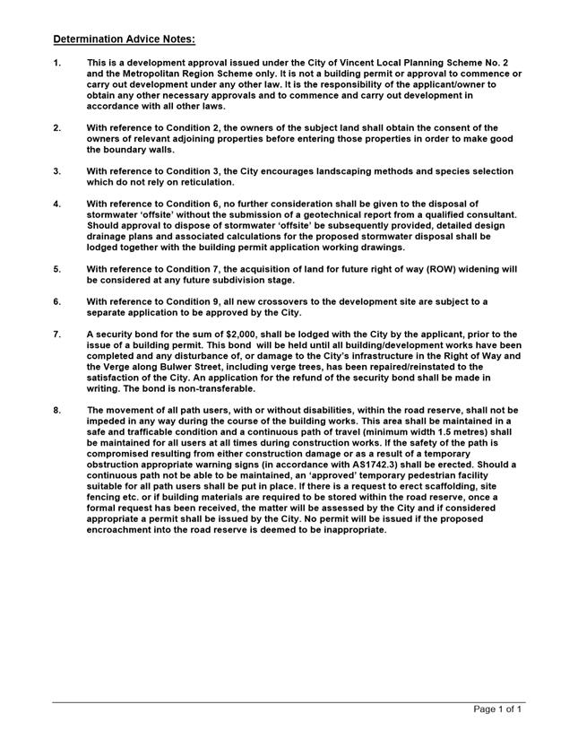
That Council, in accordance with the provisions of the City of Vincent Local Planning Scheme No. 2 and the Metropolitan Region Scheme, APPROVES the development application for Single Dwelling at No. 11 (Lot: 1: D/P: 12979) Buxton Street, Mount Hawthorn in accordance with the plans in Attachment 4, subject to the following conditions, with the associated advice noted in Attachment 8: 1. External Fixtures All external fixtures, such as television antennas (of a non-standard type), radio and other antennaes, satellite dishes, solar panels, external hot water heaters, air conditioners, and the like, shall not be visible from the street(s), are designed integrally with the building, and be located so as not to be visually obtrusive; 2. Boundary Walls The owners of the subject land shall finish and maintain the surface of the boundary wall facing 9 Buxton Street in a good and clean condition prior to the practical completion of the development and thereafter maintained to the satisfaction of the City. The finish of the walls are to be fully rendered or facebrick to the satisfaction of the City; 3. Landscaping Plan 3.1 A detailed landscape and reticulation plan for the development site and adjoining road verge, to the satisfaction of the City, shall be lodged with and approved by the City prior to lodgement of a Building Permit. The plan shall be drawn to a scale of 1:100 and show the following: · The location and type of existing and proposed trees and plants; · Areas to be irrigated or reticulated; · The provision of a minimum of 15 percent deep soil area and 30 percent canopy, as defined by the City’s Policy No. 7.1.1 – Built Form; and · The provision of trees contributing towards canopy coverage within deep soil areas provided and within the front setback area. The tree species are to be in accordance with the City’s recommended tree species list; 3.2 All works shown in the plans as identified in Condition 3.1 above shall be undertaken in accordance with the approved plans to the City’s satisfaction, prior to occupancy or use of the development and maintained thereafter to the satisfaction of the City at the expense of the owners/occupiers; 4. Visual Privacy Prior to occupancy or use of the development, all privacy screening to the balcony shall be visually impermeable and is to comply in all respects with the requirements of Clause 5.4.1 of the Residential Design Codes (Visual Privacy) deemed-to-comply provisions, to the satisfaction of the City; 5. Sight Lines No walls, letterboxes or fences above 0.75 metres in height to be constructed within the 1.5 metre of where: 5.1 walls, letterboxes or fences adjoin vehicular access points to the site; or 5.2 a driveway meets a public street; or 5.3 two streets intersect; unless otherwise approved by the City of Vincent; 6. Stormwater All stormwater produced on the subject land shall be retained on site, by suitable means to the full satisfaction of the City; 7. Right of Way (ROW) Widening 7.1 The landowner shall remove any landscaping, development or other works and shall seal, drain and grade to match the existing right of way the area within 0.5 metres of the northern boundary of the lot, within 0.5 metres of the western boundary of the lot and the 2.0 metre by 2.0 metre truncation area between the northern and western areas at the time these portions of land are ceded to the City. Any costs associated with the above are the responsibility of the owner/applicant; and 7.2 The 0.5 metre setback to the northern ROW, 0.5 metre setback to the western ROW and 2.0 metre by 2.0 metre truncation setback between the northern and western ROW setback areas referred to in condition 7.1 above, shall be ceded free of cost to the City on subdivision or amalgamation of the land, including Built Strata subdivision; 8. Outbuildings The retained outbuilding shall only be used for domestic purposes, associated with the property and not for human habitation; 9. Crossovers Prior to the first occupation of the development, redundant or “blind” crossovers shall be removed and the verge and kerb made good to the satisfaction of the City’s Engineering Directorate, at the applicant/owner(s) full expense; and 10. Colours and Materials Schedule Prior to the commencement of development a detailed schedule of external finishes (including materials and colour schemes and details) shall be submitted to and approved by the City. The development shall be finished in accordance with the approved schedule prior to the use or occupation of the development. |
Purpose of Report:
To consider an application for development approval for development approval for a single house at No.11 Buxton Street, Mount Hawthorn (subject site).
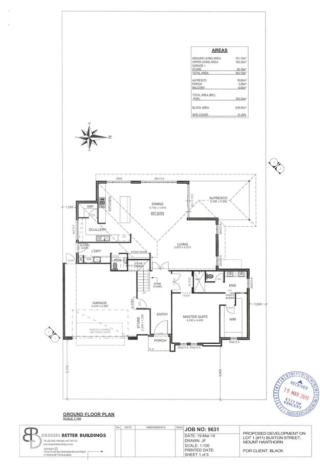
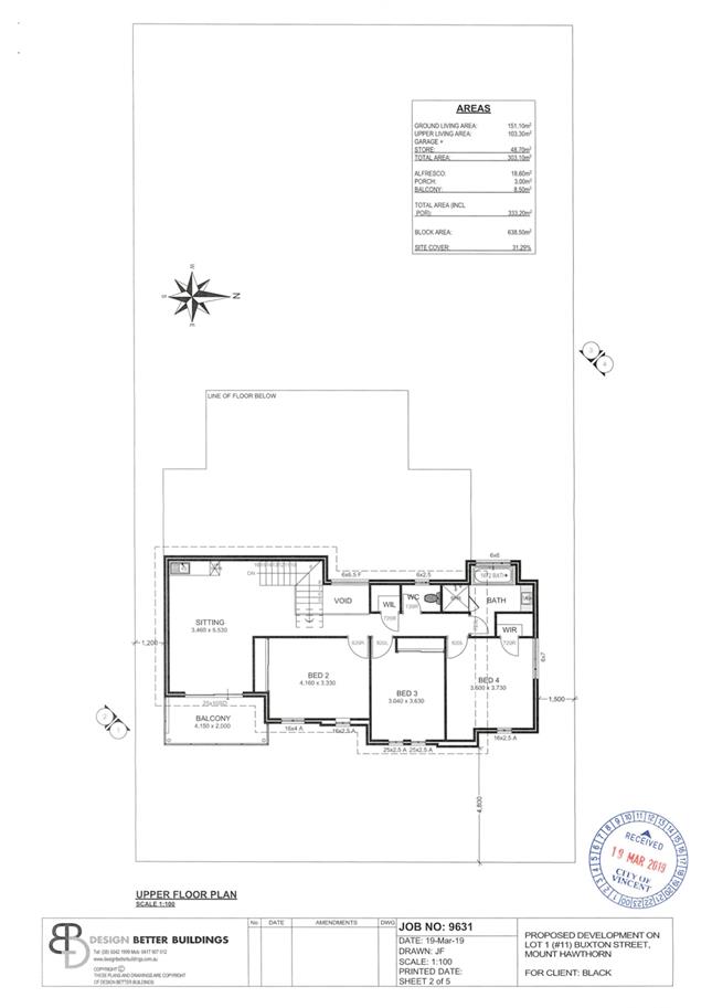
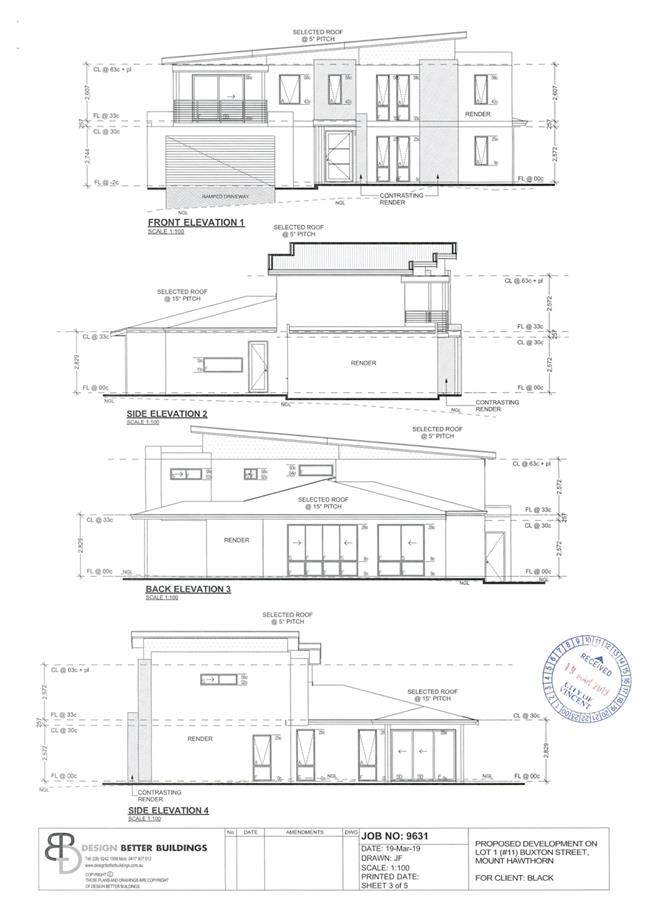
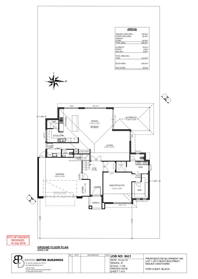
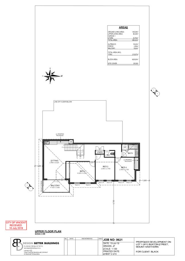
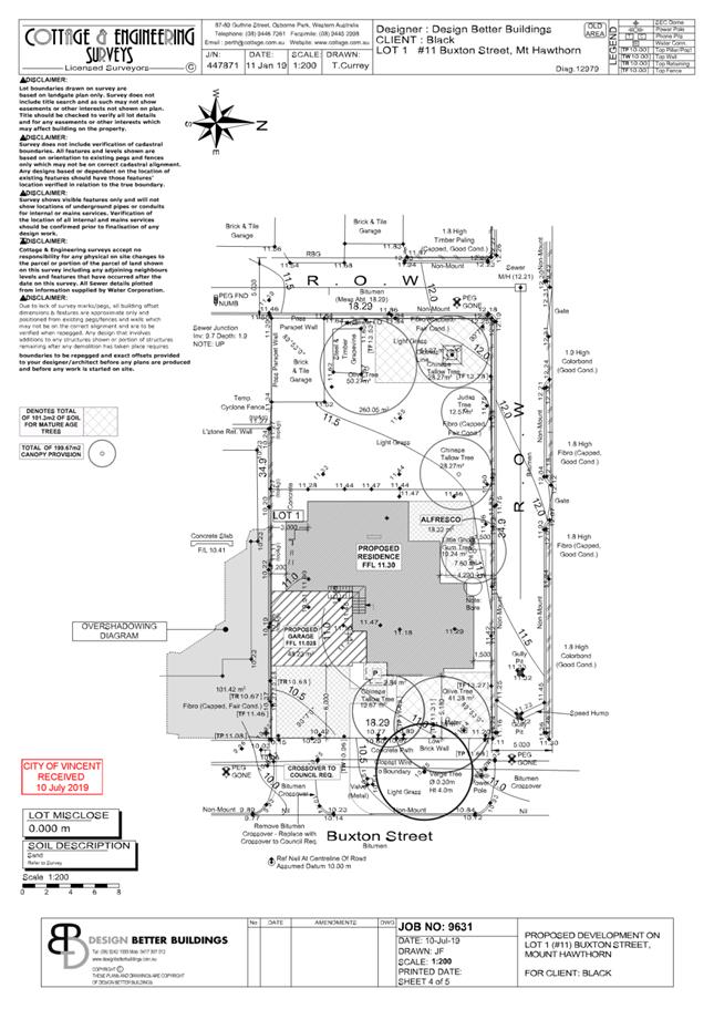
PROPOSAL:
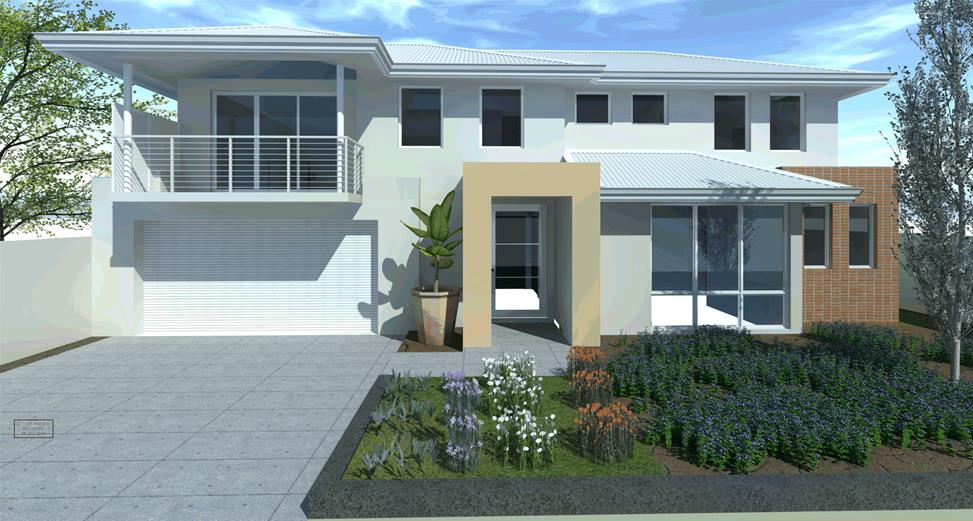
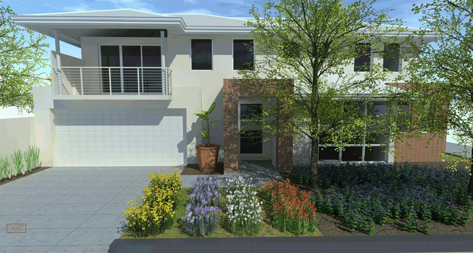
The application proposes a two storey single house which addresses Buxton Street.
Background:
|
Landowner: |
Louise Black |
|
Applicant: |
Design Better Buildings |
|
Date of Application: |
19 March 2019 |
|
Zoning: |
MRS: Urban LPS2: Residential R Code: Residential R30 |
|
Built Form Area: |
Residential |
|
Existing Land Use: |
Vacant lot (with existing outbuilding) |
|
Proposed Use Class: |
Dwelling (single) |
|
Lot Area: |
637m² |
|
Right of Way (ROW): |
North: 5.03 metre width West: 5.03 metre width |
|
Heritage List: |
N/A |
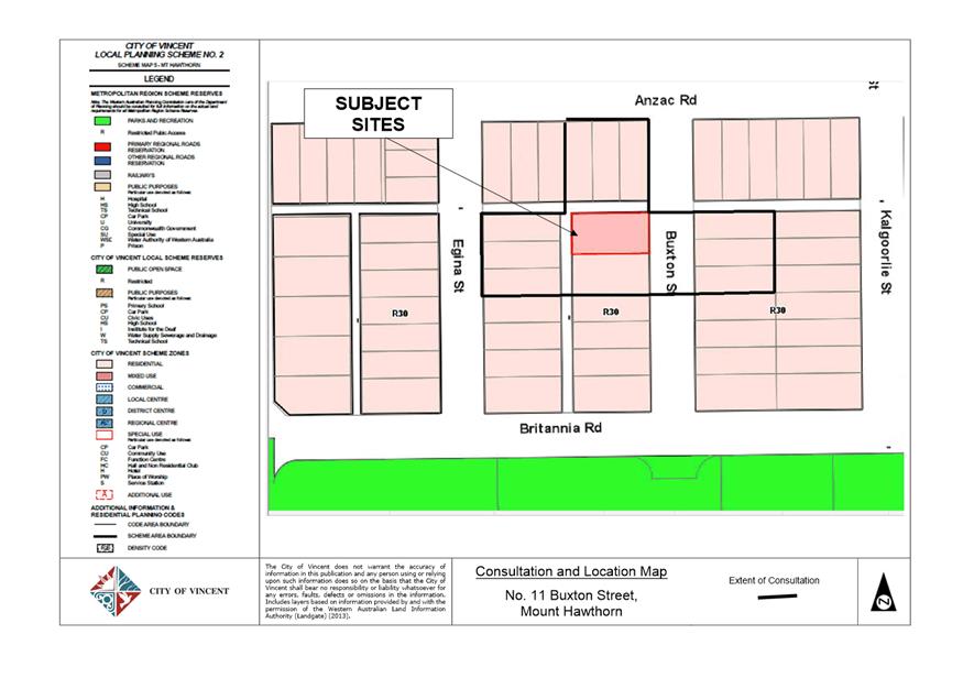
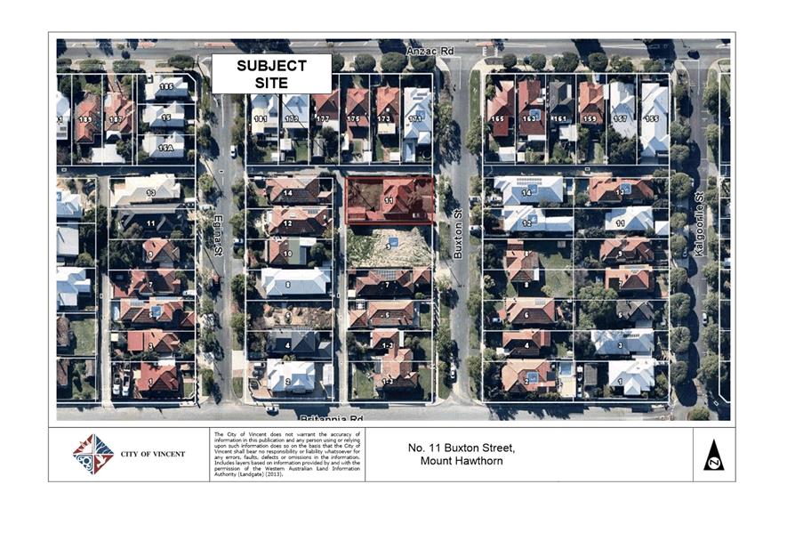
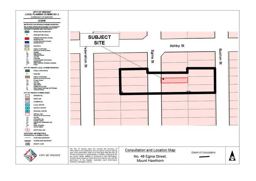
The subject site is bound by Buxton Street to the east, a two storey dwelling under construction to the south, and ROW’s ways to the north and west. A location plan is included as Attachment 1.
The surrounding residential developments to Buxton Street and the adjacent ROW are single-storey and two storey single houses. In January 2019, a demolition permit was issued for the subject site with the demolition of the works undertaken April 2019. The site is now vacant and cleared. It is noted an existing outbuilding, located in the south west corner of the site has been retained and does not form part of the current application. The site is zoned Residential with a density coding of R30. This means that the site has the potential to be subdivided in future.
A Character Retention Area nomination has been received for the portion of Buxton Street from Anzac Road to Britannia Road, which includes the subject site. Buxton Street forms part of a broader Mount Hawthorn character retention area (inclusive of portions of The Boulevarde, Kalgoorlie Street and Buxton Street) and was referred to Council at its 30 April 2019 Ordinary Meeting to present the potential area. Administration is engaging with the community to understand the streetscape issues and working collaboratively with the community to discuss potential solutions.
The development plans for the proposed dwelling have been included as Attachment 4.
Details:
Summary Assessment
The table below summarises the planning assessment of the proposal against the provisions of the City of Vincent Local Planning Scheme No. 2 (LPS2), the City’s Policy No. 7.1.1 – Built Form and the State Government’s Residential Design Codes Volume 1 (R Codes). In each instance where the proposal requires the discretion of Council, the relevant planning element is discussed in the Detailed Assessment section following from this table.
|
Planning Element |
Use Permissibility/ Deemed-to-Comply |
Requires the Discretion of Council |
|
Street Setback |
|
ü |
|
Front Fence |
ü |
|
|
Building Setbacks/Boundary Wall |
|
ü |
|
Building Height/Storeys |
|
ü |
|
Open Space |
ü |
|
|
Outdoor Living Areas |
ü |
|
|
Landscaping |
ü |
|
|
Privacy |
ü |
|
|
Parking & Access |
|
ü |
|
Solar Access |
ü |
|
|
Site Works/Retaining Walls |
ü |
|
|
Essential Facilities |
ü |
|
|
External Fixtures |
ü |
|
|
Surveillance |
ü |
|
|
Outbuildings |
ü |
|
Detailed Assessment
The deemed-to-comply assessment of the element that requires the discretion of Council is as follows:
|
Street Setback |
|
|
Deemed-to-Comply Standard |
Proposal |
|
Clause 5.2 of Built Form Policy
Average street setback: 7.3 metres |
Ground Floor: 5.2 metres to master suite
Upper Floor: 5.5 metres to Balcony 6.3 metres to Bed 2 |
|
Building Setbacks/Boundary Wall |
|
|
Deemed-to-Comply Standard |
Proposal |
|
Clause 5.1.3 of the R Codes
Average height: 3.0 metres |
Average height: 3.15 metres |
|
Building Height |
|
|
Deemed-to-Comply Standard |
Proposal |
|
Clause 5.6 of Built Form Policy
Wall height: 6.0 metres |
Wall height: 6.07 metres |
|
Parking and Access |
|
|
Deemed-to-Comply Standard |
Proposal |
|
Clause 5.3.5 of the R Codes
Access to on-site car parking spaces to be provided where available from a right of way available for lawful use to access the relevant lot and which is adequately paved and drained from the property boundary to a constructed street. |
Vehicle access to primary street (Buxton Street) |
The above elements of the proposal do not meet the specified deemed-to-comply standards and is discussed in the Comments section below.
Consultation/Advertising:
Community Consultation was undertaken in accordance with the Planning and Development (Local Planning Scheme) Regulations 2015, for a period of 14 days commencing on 9 May to 23 May 2019. Community consultation was undertaken by means of written notifications being sent to surrounding landowners, as shown in Attachment 1 and a notice on the City’s website.
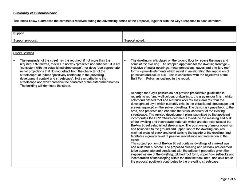
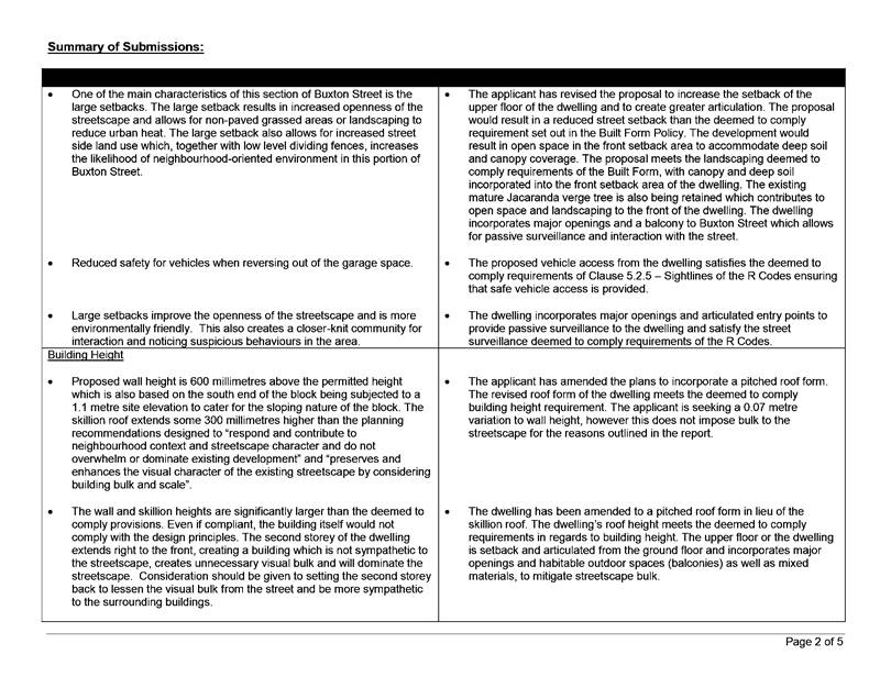
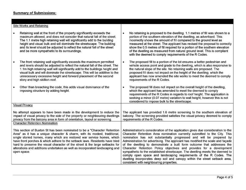
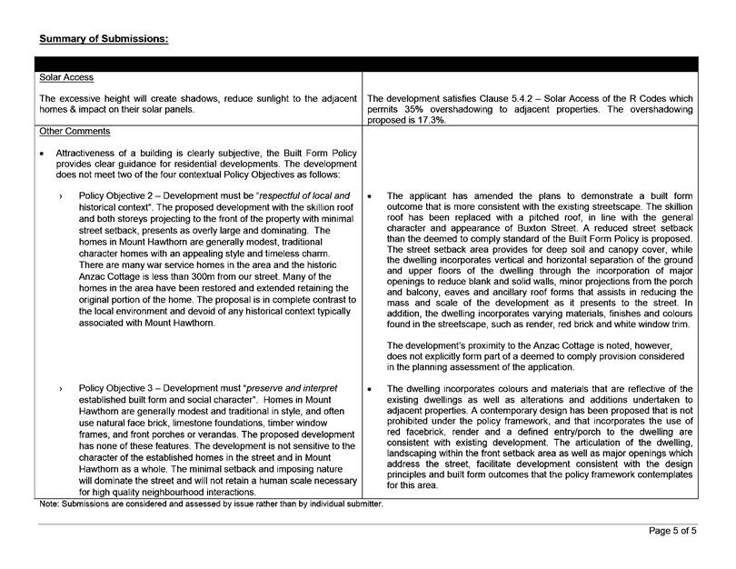
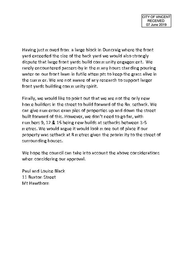
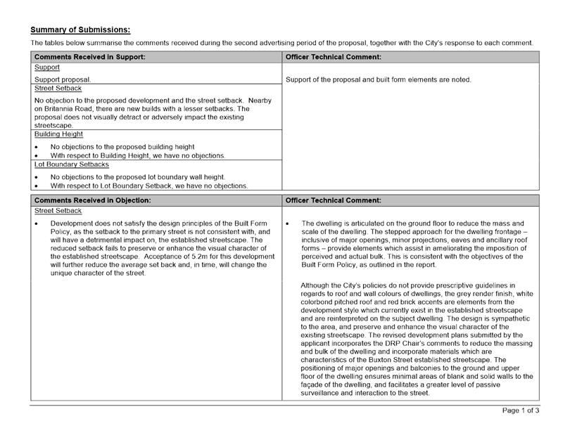
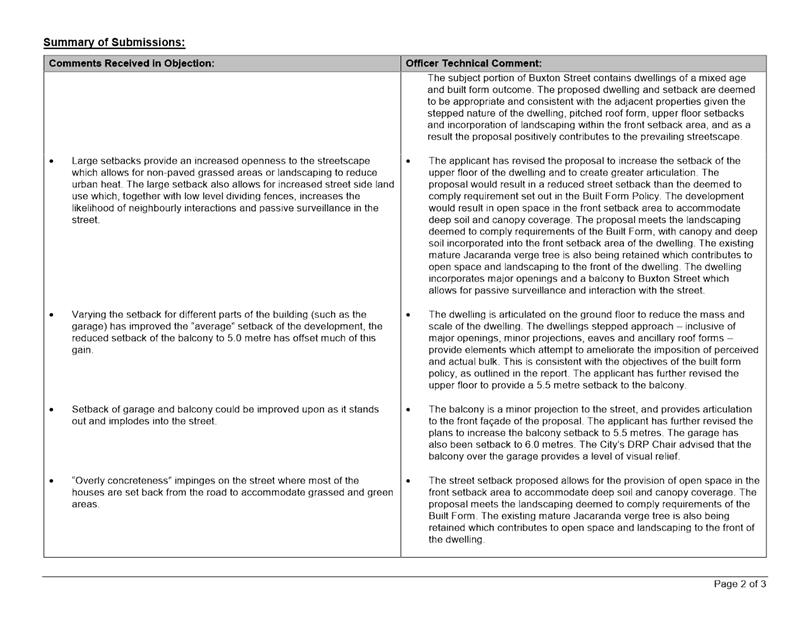
At the conclusion of the community consultation period, 10 submissions were received, nine of which objected to the proposal and one which was in support. The issues raised as part of the consultation relate to the following:
· Proposed street setback does not preserve or enhance the existing streetscape;
· Two storey scale of the development is exacerbated by the variations to building height;
· Perceived overshadowing to adjacent properties and solar panels;
· Bulk and scale of the development when viewed from the street;
· Visual privacy from the balcony to neighbouring properties and the street; and
· Development not being consistent with Character Retention Area nomination for this portion of Buxton Street.
The plans that were advertised are included as Attachment 1. A summary of the submissions and Administration’s comments on each issue is included as Attachment 5, with the applicant’s response to the submissions included in justification as Attachment 6.
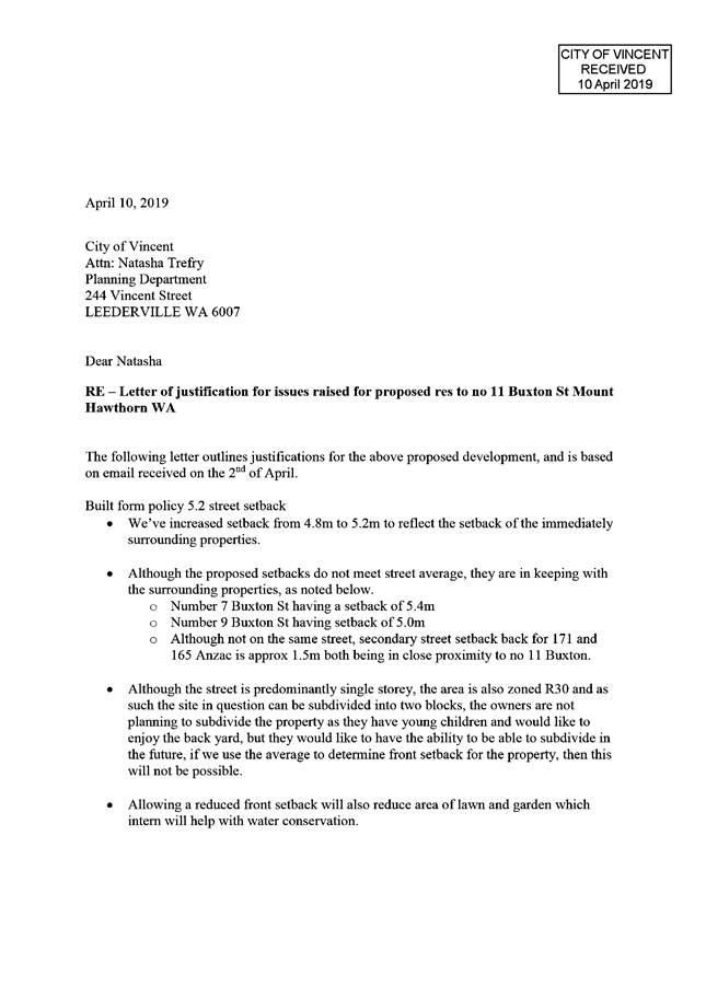
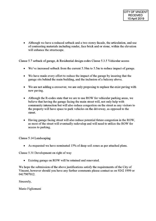
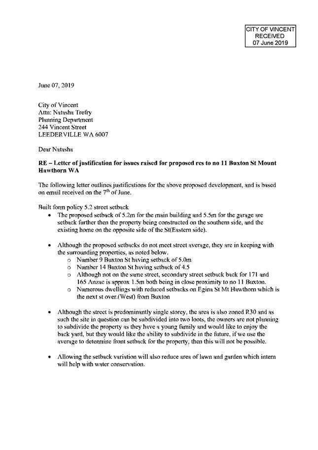
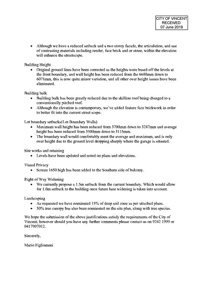
The applicant made changes to the proposal following the advertising period. These changes included:
· Increasing the setback of the upper floor from 5.0 metres to a 5.5 metre balcony setback, 6.2 metres setback to Bed 2 and 6.7 metres for the remainder of the upper floor;
· Articulating the ground and upper floors. The original plans proposed the ground and upper floors of the dwelling to the same 5.0 metre setback. The ground and upper floors of the proposal were articulated to create a stepped approach;
· Revising window size and design on the upper floor to the front façade to improve interaction with the street;
· Incorporating additional mix of colours and materials including contrasting render colours and facebrick detail to the façade; and
· Revising the roof form from a skillion to pitched roof.
A copy of these amended plans are included within Attachment 3 and justification from the applicant in regards to the street setback proposed is included as Attachment 6.
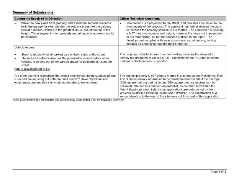
The amended plans were advertised to properties that has previously provided submissions and adjacent properties that require consultation under the City’s Policy No. 4.1.5 - Community Consultation. This consultation period was for a period of seven days, commencing on 18 July 2019 to 25 July 2019. Seven submissions were received for the revised proposal including four in objection, one with concerns and two in support. The issues raised during this consultation period related to the following:
· Proposed street setback does not preserve or enhance the existing streetscape;
· Vehicle safety from the subject lot to the street;
· Colours and materials of the dwelling; and
· Surveillance and interaction of the dwelling with the street and neighbouring properties.
A summary of the submissions and Administration’s comments for the second round of community consultation is included as Attachment 7.
Design Review Panel (DRP):
Referred to DRP: Yes
The application was referred to the City’s DRP Chair for comments following the conclusion of the first round of advertising of the proposal. Comments were sought from the DRP Chair with respect to the appropriateness of the proposed built form outcome in the streetscape context and any opportunities for the applicant to improve the design of the dwelling from this regard. Administration sought written comments from the DRP Chair and also facilitated a meeting with the DRP Chair and the applicant present.
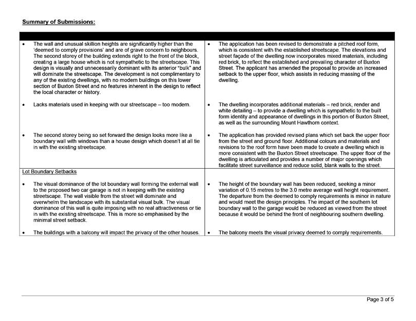
The DRP Chair noted the following comments in regards to the proposal:
· The skillion roof design element of the original proposal is removed and replaced with a pitched roof. Together with the detailing of the facades, the windows, roof, colour of walls, the dwelling appears to reflect that of No. 14 Buxton Street and adjacent properties;
· Increase the vertical and horizontal articulation of the dwelling as a whole to reduce mass and scale;
· Introduce mixed materials to the front facade which reflect the streetscape;
· Increase the setback of the upper floor to provide perceived single storey element and scale to dwelling; and
· The balcony over the garage provides a level of visual relief to the setback.
Amended plans were prepared and submitted to the City in response to the DRP Chair comments. A copy of these amended plans are included as Attachment 3. These plans and modifications were then referred back to the DRP Chair for further consideration. The DRP Chair provided the following comments in respect to the revised plans:
· The majority of the upper level floor plate has been recessed by 1.5 metres from the ground level floor plate, providing a 6.7 metre setback from the front boundary (the ground level remains at 5.2 metres setback from the front boundary);
· The applicant has also articulated the roof scape, producing a stepping affect away from the street. The more traditional articulation of the roofs is in line with many of the older properties within the surrounding area;
· These two modifications to the upper floor plan and the roof have broken down the mass and scale;
· The vernacular architectural expression would not have a detrimental impact on the streetscape;
· The current colour pallet is uncoordinated. The brick wall facing the street should either be increased in area to extend to the entry of the portico, or the applicant could render and paint this section of the building as per the main walls – with only the entry highlighted in a different colour;
· The colour palette of the development is neutral which aids in consistency with the streetscape. Colours and materials to the side and rear of the building are best left neutral; and
· In relation to the rear of the building, the upper level is well setback and the lower roof assists with breaking down the mass. What could assist is to make the roof eave overhang the upper level rear wall to soften the rear elevation.
In response to the comments from the DRP Chair, the applicant provided amended plans to address the recommendations regarding colours and materials, and the rear elevation of the proposal. The changes include:
· Incorporating highlight windows to the rear of the upper floor;
· Extending the eaves on the upper floor to the rear; and
· Facebrick finish to the porch.
A copy of these amended plans are included as Attachment 4. This is the development proposal the applicant is seeking approval for.
Legal/Policy:
· Planning and Development Act 2005;
· Planning and Development (Local Planning Schemes) Regulations 2015;
· City of Vincent Local Planning Scheme No. 2;
· State Planning Policy 7.3 – Residential Design Codes Volume 1;
· Policy No. 4.1.5 – Community Consultation;
· Policy No. 7.1.1 – Built Form Policy; and
· Policy No. 7.5.15 – Character Retention and Heritage Areas.
Delegation to Determine Applications:
The matter is being referred to Council as the application received more than five objections during community consultation.
Risk Management Implications:
There are minimal risks to Council and the City’s business function when Council exercises its discretionary power to determine a planning application.
Strategic Implications:
o This is in keeping with the City’s Strategic Community Plan 2018-2028:
Innovative and Accountable
We are open and accountable to an engaged community.
SUSTAINABILITY IMPLICATIONS:
Nil.
Financial/Budget Implications:
Nil.
Comments:
Street Setback
The development proposes a street setback of 5.2 metres to 6.0 metre articulated setback on the ground floor and 5.5 metre to 6.7 metre setback on the upper floor, in lieu of the deemed-to-comply requirement of 7.3 metres. The application was advertised with a 7.92 metre average street setback requirement, this included an additional property in the averaging calculation and was done in error. The correct average street setback requirement of 7.3 metres was confirmed after the conclusion of the first advertising period and was specified in the advertising material for the second community consultation.
The City received submissions which raised concerns with the street setback of the development during community consultation regarding preservation of the streetscape, and the dominance of the development at a reduced street setback and interaction of the dwelling with the street.
The applicant’s justification for the street setback is summarised as follows:
· Street setback of dwelling has been increased to reflect that of the directly adjacent properties;
· The lot is capable of subdivision and the large area of open space to the rear of the property provides sufficient areas for outdoor recreation;
· The current front setback area reduces the extent of lawn and garden to assist in water conservation; and
· The articulation and use of contrasting materials enhance the streetscape.
The proposed setback satisfies the relevant design principles and local housing objectives of the R Codes and Built Form Policy, and is acceptable for the following reasons:
· The development is well articulated by way of the following:
o The site is located within the Residential built form area under the Built Form Policy and permits two storey building heights. The dwelling provides vertical separation with the upper floor being setback behind the ground floor. The dwelling also provides horizontal articulation with varied setbacks of the dwelling along the ground floor and upper floor. This reduces the mass and scale of the development as it presents to the street;
o The dwelling incorporates a stepped approach in order to provide depth. This includes major openings to reduce blank and solid walls, minor projections from the porch and balcony, eaves and ancillary roof forms. This provides additional design elements to ameliorate the impacts of building bulk;
o The proposal incorporates multiple major openings to the upper floor of the dwelling from the balcony/sitting room, bed 2, bed 3 and bed 4. The balcony, which projects over the garage on the ground floor and that extends for the majority of the garage door width, assists to reduce the appearance and dominance of the garage as viewed from the street. The balcony projection also provides a greater level of passive street surveillance which consequently allows for a greater level of street interaction; and
o The dwelling includes varying materials, finishes and colours, such as render, red brick and white window trim details. This provides visual breaks and clearly distinguishes one part of the dwelling from another. The positioning of windows and balconies on the ground and upper floor of the dwelling also ensures that areas of the building façade that present as blank solid walls are minimised. These design approaches create visual interest and further assist to reduce the impact of building bulk of the development on the streetscape;
· The proposal incorporates a range of materials and finishes including elements of render, red brick and white window trim details. The City’s Built Form Policy does not provide prescriptive guidelines in regards to roof and wall colours of dwellings in Residential built form areas. The streetscape is variable, the proposed grey render finish, white colorbond pitch roof and red brick accents are building characteristics that are common in the immediate locality and have been reinterpreted in the development. The dwelling incorporates features, colours and materials found in the streetscape in order to contribute a contemporary two-storey development that maintains and enhances the visual elements of the street. This results in a two storey scale development that is not a dominant built form outcome in this portion of Buxton Street, acknowledging that two storey dwellings are permitted within the locality. The design is sympathetic to and compatible with the area, and preserves and enhances the visual character of the existing streetscape and broader locality;
· The proposal is compliant with the landscaping requirements of the Built Form Policy and incorporates deep soil and canopy within the front setback area, which includes an Olive Tree and Chinese Tallow tree, in addition to the existing street tree (Jacaranda tree). The provision of landscaping within the front setback area provides some screening to the development as well as ameliorates the bulk and scale of the development as viewed from the street. This landscaping would soften the appearance of the dwelling and would contribute to the amenity of the street;
· The portion of Buxton Street that this proposal sits within contains a mix of dwelling styles that have been constructed at different periods of time. The proposed dwelling and street setback are appropriate and consistent with the adjacent properties given the stepped nature of the dwelling, pitched roof form, upper floor setbacks and incorporation of landscaping within the front setback area. The streetscape character of Buxton Street is further detailed under the ‘Character Retention Area Nomination’ section below;
· Neighbouring properties within the Buxton Street streetscape incorporate structures within the street setback area including street walls and fences, and carports. The proposed dwelling does not propose these structures within the street setback which facilitates an open street setback area with landscaping; and
· The revised development plans submitted by the applicant incorporates the DRP Chair’s comments to reduce the massing and bulk of the dwelling, and to incorporate materials that are characteristics of the Buxton Street established streetscape.
Lot Boundary Setbacks (Lot Boundary Walls)
The average height of the southern lot boundary wall to the garage is proposed at 3.15 metres in lieu of the deemed-to-comply 3.0 metre average.
The City received submissions raising concerns with the southern lot boundary wall to the garage, in regards to the visibility and impact of the boundary wall to the streetscape and the wall appearing unattractive to the street.
The applicant’s justification for the lot boundary wall is summarised below:
· The scale of the lot boundary wall has been reduced from that initially proposed. The maximum wall height has been reduced from 3.7 metres to 3.3 metres, while the average wall height is also reduced from 3.5 metres to 3.15 metres.
· The boundary wall only seeks a variation due to the natural slope of the site which is at its lowest on the southern boundary, where the garage boundary wall is located.
The lot boundary wall satisfies the relevant design principles and local housing objectives of the R Codes and Built Form Policy, and is acceptable for the following reasons:
· The proposed wall meets the deemed-to-comply requirements for the length of the wall. The length of wall proposed is 6.9 metres in lieu of the permitted 17.7 metres. This assists with reducing the scale and impact of the boundary wall as viewed from the adjacent property and street;
· The garage wall abutting the neighbouring southern property is to an area of open space and an access leg to the rear and side boundaries of the site; and
· The proposed wall is located on the southern boundary and does not compromise access to direct sunlight for the subject dwelling and does not adversely impact adjoining properties with respect to overshadowing as the deemed-to-comply solar access requirement is met.
Building Height
The wall height of the dwelling to the south-eastern portion is proposed to 6.07 metres in lieu of the 6.0 metre deemed-to-comply requirement.
Concerns were raised in submissions regarding the height of the building, including its consistency with the existing streetscape in terms of scale and roof form, concerns over access to light and ventilation for adjacent properties, as well as the impact of the second storey element to the streetscape. The application was submitted with departures to deemed-to-comply requirements of both wall height and roof height of the dwelling. The applicant has since revised the proposal to meet the roof height deemed-to-comply requirements and reduce the wall height.
The applicant’s justification for the building height is summarised below.
· The initial building height was noted against the levels of the street boundary. The revised levels of the site reduce the building height scale and impacts;
· Building bulk has been greatly reduced with the skillion roof replaced with a pitched roof; and
· Variations to building height for the remainder of the dwelling have been eliminated in revised plans for the proposal.
The proposed building height satisfies the relevant design principles and local housing objectives of the R Codes and Built Form Policy, and is acceptable for the following reasons:
· The 0.07 metre departure to the deemed-to-comply requirement applies only to a portion of the development, being the south-east of the front façade. This is as a result of the natural slope of the site, with the natural ground level of the site sloping down from approximately 11.5 at the north-western portion of the proposed building to 10.5 at the south-eastern portion of the proposed building. The remainder of the dwelling meets the deemed-to-comply building height requirements and does not result in height departures across the site;
· The proposal satisfies the deemed-to-comply requirements for roof height of the dwelling;
· The southern boundary of the dwelling is articulated and stepped from the boundary to mitigate bulk and scale to adjacent properties and the streetscape;
· The dwelling meets the visual privacy and solar access deemed-to-comply requirements;
· The wall height of the dwelling is in response to the site level affecting the south-eastern portion of the lot. Limited fill is proposed and the site works deemed-to-comply requirements are satisfied; and
· The dwelling is located within a two-storey built form area and the proposed dwelling is consistent with this permitted built form outcome.
Parking and Access
The application proposes vehicle access from the primary street, Buxton Street, in lieu of from the right of way. The proposed vehicle access to the site satisfies the relevant design principles and local housing objectives of the R Codes are is acceptable for the following reasons:
· The vehicle access to the site is the same location as the previous dwelling on the lot.
· The proposed access point from Buxton Street would not be out of character with the existing streetscape which includes a number of garages and carports such as those at No. 9 Buxton Street and No. 14 Buxton Street to the south and east of the subject site. These garages are setback 6.0 metres and 6.1 metres from the lot boundary respectively, consistent with the 6.0 metres that is proposed in the subject application. It is also noted carports are located within the front setback of lots in the locality. This includes No. 7 Buxton Street, a double carport which is setback approximately 1.5 metres from the street boundary;
· Buxton Street is identified as an ‘access road’ which is the lowest category road under the Main Roads road hierarchy. The R Codes permit vehicle access from access roads and the proposed vehicle access for the subject development would not result in an unsafe access arrangement for ingress and egress from the site;
· The vehicle access ensures pedestrian and vehicle access safety, as the proposal meets the deemed-to-comply requirements in regards to sight lines, with no structures greater than 0.75 metres located within the 1.5 metre truncation area;
· The 5.0 metre driveway width at the lot boundary is less than the 6 metre width allowable under the deemed-to-comply requirements of the R Codes. The design of the driveway reduces the width of access points on the streetscape. The reduced driveway width also allows for additional landscaping within the front setback area, consequently reducing the hardstand areas;
· The tapered driveway to the southern boundary provides a 0.6 metre to 0.8 metre side boundary setback to meet the deemed-to-comply requirements of the R Codes and assist in the reduction of vehicle access points; and
· The proposed vehicle access widths allows for the provision of deep soil areas and trees that would contribute to mature canopy coverage within the street setback area. This would contribute positively to the streetscape and reduce the impact of vehicle access points.
Landscaping
In addition to the deemed-to-comply standards of the R Codes, the application has also been assessed against the landscaping provisions of the Built Form Policy that sets out additional deemed-to-comply standards. The deemed-to-comply landscaping standards set out in the Built Form Policy have not yet been approved by the WAPC and as such, these provisions are given due regard in the assessment of the application.
The Built Form Policy requires 15 percent of the site to be provided as deep soil zone and 30 percent of the site provided as canopy coverage at maturity. The application proposes 15.9 percent deep soil zone and 31.3 percent canopy coverage at maturity. In relation to landscaping:
· The application proposes trees within the rear setback area abutting the northern lot boundary which would soften the appearance of the development from the adjoining property;
· The application proposes two trees with large canopy coverage - Chinese Tallow and Olive Tree within the street setback area, which would soften the appearance of the development from the street;
· The proposal retains the existing mature Jacaranda tree in the verge area abutting the proposed development. The retained tree contributes to canopy cover in the area;
· The proposed landscaping includes portions of canopy which extend outside of the lot boundaries, contributing to the provision of landscaping within the broader area;
· The proposed landscaping would provide increased amenity for the future occupants of the site and the surrounding area;
· The application proposes ground cover landscaping along the street boundaries in conjunction with the mature canopy coverage within the street setback areas; and
· The proposed landscaping does not negatively impact the use and activation of the ROW as would not impede surveillance between the subject dwelling, Buxton Street and the abutting ROW's.
ROW Widening
The subject site is bordered by ROW’s to the northern and western boundaries of the lot. Both ROW’s are 5.03 metres in width and are in the ownership of the City.
The 6.0 metre ROW width standard included in the Western Australian Planning Commission’s (WAPC) Planning Bulletin 33 (PB33) would require a widening of 0.5 metres to be provided along the northern and western boundaries of the lot. The widening does not impact on any active open space and can be accommodated within the currently proposed development. PB33 notes widening is to facilitate sufficient vehicle manoeuvring of 6.0 metres for vehicles to enter and exit a lot.
The applicant is aware of the need for ROW widening in the future should the lot be subdivided. At this time, the City would review the proposed subdivision and seek to cede the 0.5 metre ROW widening portions to the western and northern boundaries of the subject lot.
Character Retention Area Nomination
The City has received a Character Retention Area nomination for the portion of Buxton Street from Anzac Road to Britannia Road, Mount Hawthorn. This area includes a total of 13 dwellings. The nomination has been amalgamated with other precincts within the Mount Hawthorn area to provide a collective of character retention precincts. While the Character Retention nomination has not been presented to Council, Administration has given due regard to the objectives of Policy No. 7.5.15 – Character Retention and Heritage Areas (Character Retention Policy) in the assessment of the subject proposal.
The Character Retention Policy notes that the characteristics of streetscapes can encompass, but are not limited to “architectural style, built form, building materials, front fencing and vegetation and includes the non-physical elements including front setback distances, the spacing of dwellings (side setbacks), and how these elements relate to the area”.
The application is consistent with the objectives of the Character Retention Policy in terms of the dwelling’s built form, presentation to the street and the impact of development on the neighbouring properties. The applicant has amended the design of the proposal to reflect the identifiable and key streetscape character of Buxton Street. The changes undertaken include:
Roof Form
· The proposal has been amended from a skillion roof to a pitched roof. The roof form of the dwelling is consistent with not only the adjacent properties but the streetscape as a whole; and
· All dwellings within the established Buxton Street streetscape have pitched roof forms, and the pitch roof form of the subject property provides a level of consistency and continuity which aids in the preservation and enhancement of the streetscape.
Colours and Materials
The dwelling incorporates a mix of materials which are characteristic of and are consistent with the established Buxton Street streetscape. The dwelling incorporates red brick as well as grey and white render detailing. These materials are consistent with the older dwellings, more recent developments, as well as alterations and additions such as street walls and fences which have been undertaken to adjacent dwellings.
Building Bulk and Scale
· The application has set back the upper floor of the dwelling to create a stepped approach which creates depth and separation of the upper floor from the ground floor. Vertical and horizontal separation of the ground and upper floors of the dwelling through the incorporation of major openings to reduce blank and solid walls, minor projections from the porch and balcony, eaves and ancillary roof forms, reduces the mass and scale of the development as it presents to the street. In addition, the dwelling incorporates varying materials, finishes and colours, such as render, red brick and white window trim details to create visual interest and further assist to reduce the impact of building bulk and scale of the development on the streetscape; and
· The minor projection of the balcony over the garage on the ground floor extends for the majority of the garage door width, which assists in the reduction of garage dominance as viewed from the street. The balcony projection also provides a greater level of passive street surveillance which consequently allows for a greater level of street interaction.
TRIM Ref: D19/101127
Author: Clair Morrison, Urban Planner
Authoriser: Jay Naidoo, Manager Development & Design
Ward: North
Attachments: 1. Consultation
and Location Map ⇩ ![]()
2. Development Plans
⇩ ![]()
3. Summary of
Submissions - Administration's Response ⇩ ![]()
|
That Council, in accordance with the provisions of the City of Vincent Local Planning Scheme No. 2 and the Metropolitan Region Scheme, REFUSES the application for the proposed Single House at No. 48 (Lot: 202; D/P: 413236) Egina Street, Mount Hawthorn, in accordance with the plans in Attachment 2, for the following reasons 1. The proposed lot boundary wall along the northern lot boundary does not satisfy the Design Principles of Clause 5.1.3 Lot Boundary Setbacks of State Planning Policy 7.3 Residential Design Codes – Volume 1 as the design and materials of the lot boundary wall presents an unacceptable level of building bulk and scale which; 1.1 Has not been designed to reduce the impact of building bulk to No. 48A Egina Street, Mount Hawthorn; 1.2 Results in a detrimental amenity impact to the use and enjoyment of No. 48A Egina Street, Mount Hawthorn; and 1.3 The lot boundary does not preserve the visual character of Egina Street, and negatively impacts on the streetscape and character of the street; and 2. As a result of the bulk impact of the proposed two-storey boundary wall, the development: 2.1 Is not compatible with the established residential area in which it is located and is inconsistent with an objective of the Residential zone under the Scheme; 2.2 Is not compatible with its setting (Clause 67(m) of the Deemed Provisions in Schedule 2 of the Planning and Development (Local Planning Schemes) Regulations 2015); and 2.3 Would have an adverse impact on the amenity and a detrimental impact on the character of the locality (Clause 67(n) of the Deemed Provisions in Schedule 2 of the Planning and Development (Local Planning Schemes) Regulations 2015). |
Purpose of Report:
To consider an application for development approval for a two-storey Single House at No. 48 Egina Street, Mount Hawthorn (the subject site).
PROPOSAL:
The application proposes the construction of a two-storey Single House at the subject site.
Background:
|
Landowner: |
Colin Roe and Corinne Roe |
|
Applicant: |
Urbanista Town Planning |
|
Date of Application: |
17 May 2019 |
|
Zoning: |
MRS: Urban LPS2: Zone: Residential R Code: R30 |
|
Built Form Area: |
Residential |
|
Existing Land Use: |
Vacant |
|
Proposed Use Class: |
Single House |
|
Lot Area: |
306m2 |
|
Right of Way (ROW): |
No |
|
Heritage List: |
No |
The subject site is bound by Egina Street to the west, Single Houses to the south and east, and a vacant green title lot to the north (No. 48A Egina Street), as shown on the location plan included as Attachment 1. Egina Street and the broader area surrounding the subject site is characterised by one and two-storey Single Houses.
The subject site is currently a vacant lot that has been cleared in preparation for development. The subject site is one of two green title lots created as a result of subdivision approval issued by the Western Australian Planning Commission (WAPC) on 28 February 2017. The City issued a clearance for the subdivision approval on 24 July 2018. The City was notified on 29 January 2019 that the Deposited Plan and Certificate of Title had been issued by Landgate.
Previous Development Application
At its Ordinary Meeting on 16 October 2018, Council considered a development application for two Grouped Dwellings at the parent lot of the subject site, No. 48 (Lot: 5; D/P: 14389) Egina Street. Council resolved to refuse the application for the following reasons:
1. The development does not satisfy the design principles of Clause 5.1.2 (Street Setback) of the Residential Design Codes or Clause P5.2.1 of the Built Form Policy, as the setback to the primary street is not consistent with, and will have a detrimental impact on, the established streetscape.
2. The development does not satisfy the design principles of Clause 5.2.1 (Setback of garages and carports) of the Residential Design Codes or Clause P5.7.2 of the Built Form Policy, as the visual dominance of the proposed garages compromise the character and the existing streetscape.
The applicant sought a review of this decision by the State Administrative Tribunal (SAT) on 26 October 2018. Pursuant to Section 31 of the State Administrative Tribunal Act 2004, the SAT invited the Council to reconsider its decision. Prior to the application for reconsideration being presented to Council, Administration was provided with a copy of the Deposited Plan and Certificate of Title for the subdivided lots (No. 48A (Lot 201) Egina Street and No. 48 (Lot 202) Egina Street) by the applicant on 29 January 2019. As a result, the application presented to Council for reconsideration was for two Single Houses, rather than two Grouped Dwellings. Council reconsidered amended plans at its Ordinary Meeting on 5 February 2019 where it resolved to refuse the application for the following reasons:
1. As a consequence of the bulk, scale and dominating appearance of the proposed garages of the single houses, the proposed development:
(a) is not compatible with the established residential area in which it is located and is, therefore, inconsistent with an objective of the Residential zone under the Scheme;
(b) is not compatible with its setting (clause 67(m) of the deemed provisions in schedule 2 of the Planning and Development ( Local Planning Schemes) Regulations 2015); and
(c) would have an adverse impact on the amenity of the locality (clause 67(n) of the deemed provisions).
2. Contrary to an objective of the Residential zone under the Scheme, the design of the proposed development is contrary to sustainability principles because:
(a) the landscaping design would restrict solar access and ventilation to private open space areas of the single houses; and
(b) the building design, including a two storey boundary wall, would restrict solar access and ventilation to No. 48 Egina Street, Mount Hawthorn.
3. The matters referred to in paragraphs 2(a) and (b) would have an adverse impact on the amenity of the occupants of the proposed development.
4. Adequate landscaping on-site has not been provided to reduce the impact of the proposed development on adjoining properties and the streetscape (clause 67(p) of the deemed provisions).
Following Council’s decision, the SAT dismissed the applicant’s application for review. This was on the basis that Landgate had issued the Deposited Plan and Certificate of Title for the two green title lots at No. 48A (Lot 201) Egina Street and No. 48 (Lot 202) Egina Street. SAT determined that this meant that Lot 5 (being the parent lot) no longer existed and a decision could not be made on the development application.
Current Development
Following the dismissal of the SAT review, the applicant submitted two separate development applications for Single Houses at the subject site and at No. 48A Egina Street, Mount Hawthorn. The plans that form the subject development application for a Single House do not vary from those determined by Council at its Ordinary Meeting of Council held 5 February 2019 and are contained in Attachment 2.
The development application for a Single House on No. 48A Egina Street is also on this Ordinary Meeting agenda for Council’s consideration and determination. Administration has assessed each application independently from one another.
Details:
Summary Assessment
The table below summarises the planning assessment of the proposal against the provisions of the City of Vincent Local Planning Scheme No. 2 (LPS2), the City’s Policy No. 7.1.1 – Built Form (Built Form Policy) and the State Government’s Residential Design Codes (R Codes – Volume 1). In each instance where the proposal requires the discretion of Council, the relevant planning element is discussed in the Detailed Assessment section following from this table.
|
Planning Element |
Use Permissibility/ Deemed-to-Comply |
Requires the Discretion of Council |
|
Land Use |
ü |
|
|
Street Setback |
ü |
|
|
Building Setbacks/Boundary Wall |
|
ü |
|
Building Height/Storeys |
ü |
|
|
Open Space |
ü |
|
|
Outdoor Living Areas |
ü |
|
|
Landscaping (R Codes) |
ü |
|
|
Privacy |
ü |
|
|
Parking & Access |
ü |
|
|
Bicycle Facilities |
ü |
|
|
Solar Access |
ü |
|
|
Site Works/Retaining Walls |
ü |
|
|
Essential Facilities |
ü |
|
|
External Fixtures |
ü |
|
|
Surveillance |
ü |
|
Detailed Assessment
The deemed-to-comply assessment of the element that requires the discretion of Council is as follows:
|
Lot Boundary Walls |
|
|
Deemed-to-Comply Standard |
Proposal |
|
Built Form Policy Clause 5.3 Lot Boundary Setbacks
Where the wall abuts an existing or simultaneously constructed wall of a similar of greater dimensions; or
Boundary walls to a maximum height of 3.5 metres and average height of 3 metres for up to two-thirds of the lot boundary behind the front setback. |
Northern Lot Boundary Wall Average Height – 4.75 metres Maximum Height – 6.0 metres
No existing boundary wall on adjoining site and no boundary wall proposed to be simultaneously constructed as part of this application. |
The above element of the proposal does not meet the specified deemed-to-comply standards and is discussed in the Comments section below.
Consultation/Advertising:
Community consultation was undertaken in accordance with the Planning and Development (Local Planning Schemes) Regulations 2015 (Regulations 2015), for a period of 14 days commencing on 10 June 2019 and concluding on 25 June 2019. Community consultation was undertaken by means of written notification being sent to surrounding landowners, as shown in Attachment 1 and a notice on the City’s website.
In response to community consultation, eight submissions were received, all objecting to the proposed development. Concerns raised during the community consultation period relating the proposed Single House are as follows:
· The bulky nature of the development as a result of the lot boundary wall height and landscaping;
· The proposal does not reflect the established streetscape and characteristics of Egina Street;
· The proposed double garage is not subservient to the dwelling and dominate the street façade and are not a favourable outcome for the street;
· The cumulative impact of bulk, height, scale and appearance of the proposal is not compatible with the surrounding houses and isn’t compatible with its setting;
· The proposed balcony is not set back far enough and increases the visual bulk of the dwelling by bringing floor space out towards the street, and does not reflect the existing streetscape characteristics;
· The proposal is not consistent with maintaining the character of Mount Hawthorn; and
· There is inadequate landscaping which does not reflect the existing character of the street nor create a sense of open space between buildings.
A summary of the submissions received and Administration’s response is included as Attachment 3. The applicant has not provided any response to the summary of submissions.
Design Review Panel (DRP):
Referred to DRP: No.
Legal/Policy:
· Planning and Development Act 2005;
· Planning and Development (Local Planning Schemes) Regulations 2015;
· City of Vincent Local Planning Scheme No. 2;
· State Planning Policy 7.3 – Residential Design Codes Volume 1;
· Policy No. 4.1.5 – Community Consultation; and
· Policy No. 7.1.1 – Built Form Policy.
In accordance with Schedule 2 Clause 76(2) of the Planning and Development (Local Planning Scheme) Regulations 2015 and Part 14 of the Planning and Development Act 2005, the applicant would have the right to apply to the SAT for a review of Council’s determination.
The deemed-to-comply landscaping standards set out in the Built Form Policy have not been approved by the WAPC. The WAPC has issued approval for a modified set of deemed-to-comply landscaping standards that are similar to those set out in Residential Design Codes Volume 2 – Apartments (R Codes Volume 2 – Apartments) but which have not been approved by Council. As a result, the assessment would only have ‘due regard’ to those deemed-to-comply standards relating to landscaping approved by Council in the Built Form Policy.
Delegation to Determine Applications:
This application is being presented to Council as it received more than five objections during community consultation.
Risk Management Implications:
There are minimal risks to Council and the City’s business function when Council exercises its discretionary power to determine a planning application.
Strategic Implications:
This is in keeping with the City’s Strategic Community Plan 2018-2028:
Innovative and Accountable
We are open and accountable to an engaged community.
SUSTAINABILITY IMPLICATIONS:
Nil.
Financial/Budget Implications:
Nil.
Comments:
The proposed Single House presents the same built form as the southern dwelling in the previously refused development application for two Single Houses at No. 48 (Lot: 5; D/P: 14389) Egina Street, Mount Hawthorn. Administration previously supported the proposed lot boundary walls as the dwellings formed part of one application, and Administration contemplated the simultaneous construction of the dwellings and lot boundary walls via a planning condition of approval. This was to ensure compliance with the deemed-to-comply standards of the R Codes Volume 1 relating to lot boundary walls.
In assessing the subject development application for a Single House, the City does not have the ability to require two separate dwellings proposed on two separate green title lots that are the subject of two separate applications to be constructed simultaneously. The proposed two-storey northern lot boundary wall constructed independently would fail to meet the relevant design principles relating to lot boundary walls and would adversely impact the adjoining neighbour (No. 48A Egina Street) and the streetscape. This is discussed further below.
Lot Boundary Walls
The proposal incorporates a northern lot boundary wall with an average height of 4.75 metres and maximum height of 6.0 metres, in lieu of the Built Form Policy deemed-to-comply standard of 3.0 metre average height and 3.5 metre maximum height. The lot boundary wall extends for a total of 20.4 metres behind the street setback line.
The lot boundary wall does not satisfy the design principles and local housing objectives of the R Codes Volume 1 and Built Form Policy, respectively, for the following reasons:
· A blank two storey boundary wall does not reflect the existing character of Egina Street, given it would be the only example of this scale of lot boundary wall within the street;
· The lot boundary wall would not preserve the visual character of Egina Street, given the cumulative impact of its single material, lack of articulation, overall height, length and scale. The wall would present an unacceptable level of bulk and would not enhance the visual character of the street; and
· The overall impact of the abovementioned considerations would negatively impact on the amenity and use of the northern adjoining lot, and does not positively contribute to the prevailing character of the street.
The lot boundary wall has been assessed against Clause 67(m) and (n) of the Planning and Development (Local Planning Schemes) Regulations 2015. The proposed lot boundary wall is not considered to satisfy these clauses as the blank two-storey lot boundary wall would result in an unacceptable amount of building bulk when viewed from the street and the adjoining northern property, and as there are no design elements such as multiple materials or articulation to assist in reducing the bulk and scale of the wall.
Landscaping
The proposal results in canopy cover of 21.8 percent of the subject site in lieu of the deemed-to-comply requirement of 30 percent. The landscape plan presents two trees in the street setback area, one Chinese Tallow and one Crepe Myrtle, which grow to a height of approximately 8.0 metres at maturity. The plan also incorporates three trees in the rear yard, one Magnolia tree and two Flowering Plum trees, which grow to a height of approximately 3.0 metres and 4.0 metres, respectively. The proposed species and location of landscaping satisfies the local housing objectives of the Built Form Policy for the following reasons:
· The subject site is currently clear of any vegetation, the increased canopy would provide an increased urban air quality and reduce the impact of the urban heat island effect within the City;
· The location of landscape and the size of chosen species at maturity presents a demonstrated contribution to the greener landscape amenity within the City;
· The proposed tree species are consistent with the City’s tree selection tool and are capable of growing to a substantially greater height and canopy than that shown on the development plans. This may impact on the viability of the trees given the trees are proposed to be planted within close proximity to each other. This would maximise canopy coverage onsite;
· The location of landscaping within the street setback area and to the rear of the property assists in reducing the impact of the Single House on the public realm and adjoining residential lots; and
· The proposed landscaping would provide landscape amenity for residents of the subject site and adjoining residents.
Concerns raised During Community Consultation
Garage
The proposal presents a double garage to the street. The proposed garage satisfies the deemed-to-comply standard of Clause 5.7 Setback of Garages and Carports as it is set back more than 0.5 metres behind the building line of the dwelling. The proposal is not subject to assessment against Clause 5.2.2 Garage Width of the R Codes – Volume 1 as it is not located within 1.0 metre of the building.
Streetscape and Character
The proposal has been assessed against the relevant matters to be considered under Clause 67(m) and (n) of the Planning and Development (Local Planning Schemes) Regulations 2015 relating to the compatibility of the setting and amenity impacts on the character of the locality. Egina Street is characterised by single and two-storey Single Houses that present double garages to the street. There are no examples of double garages that occupy greater than 50 percent of the lot width. There is potential for the creation of lots through subdivision that comply with the planning framework and that have a side-by-side lot configuration, including along Egina Street. This is relevant when considering the future streetscape character of Egina Street.
The façade of the development to the street incorporates design elements and characteristics that are compatible with Clause 67(m) and (n) of the Planning and Development (Local Planning Schemes) Regulations 2015 for the following reasons:
· The street is characterised by Single Houses with double garages, with a significant number of garages being in line or in front of the dwelling;
· The materials and design elements used in the street façade, including facebrick, render and pitched roof reflect common characteristics and design elements along Egina Street;
· The cumulative effect of the street setback, proposed canopy coverage and inclusion of an open-faced balcony to the street façade assists in mitigating the overall impact of building bulk and scale; and
· The proposed garage would not result in an adverse impact on the use or amenity of the adjoining southern lot given the garage is setback behind the alignment of the porch at neighbouring property No. 46 Egina Street and overshadowing to this property complies with the deemed-to-comply requirement of the R Codes Volume 1. The proposed garage is also located behind the balcony on the subject site.
TRIM Ref: D19/101126
Author: Clair Morrison, Urban Planner
Authoriser: Jay Naidoo, Manager Development & Design
Ward: North
Attachments: 1. Consultation
and Location Map ⇩ ![]()
2. Development Plans
⇩ ![]()
3. Summary of
Submissions - Administration Response ⇩ ![]()
|
That Council, in accordance with the provisions of the City of Vincent Local Planning Scheme No. 2 and the Metropolitan Region Scheme, REFUSES the application for the proposed Single House at No. 48A (Lot: 201; D/P: 413236) Egina Street, Mount Hawthorn, in accordance with the plans in Attachment 2, for the following reasons: 1. The proposed lot boundary wall along the southern lot boundary does not satisfy the Design Principles of Clause 5.1.3 Lot Boundary Setbacks of State Planning Policy 7.3 Residential Design Codes – Volume 1 as the design and materials of the lot boundary wall presents an unacceptable level of building bulk and scale which; 1.1 Has not been designed to reduce the impact of building bulk to No. 48 Egina Street, Mount Hawthorn; 1.2 Results in a detrimental amenity impact to the use and enjoyment of No. 48 Egina Street, Mount Hawthorn; and 1.3 The lot boundary wall does not preserve the visual character of Egina Street, and negatively impacts on the streetscape and character of the street; 2. As a result of the bulk impact of the proposed two-storey boundary wall, the development: 2.1 Is not compatible with the established residential area in which it is located and is inconsistent with an objective of the Residential zone under the Scheme; 2.2 Is not compatible with its setting (Clause 67(m) of the Deemed Provisions in Schedule 2 of the Planning and Development (Local Planning Schemes) Regulations 2015); and 2.3 Would have an adverse impact on the amenity and a detrimental impact on the character of the locality (Clause 67(n) of the Deemed Provisions in Schedule 2 of the Planning and Development (Local Planning Schemes) Regulations 2015); and 3. The proposed development does not satisfy the Design Principles of Clause 5.4.2 Solar Access for Adjoining Sites of State Planning Policy 7.3 Residential Design Codes – Volume 1 and is contrary to sustainability principles that is an objective of the Residential Zone under the Scheme because: 3.1 The extent of overshadowing falls onto a significant portion of the southern adjoining site behind the street setback line, which restricts solar access to No. 48 Egina Street, Mount Hawthorn; and 3.2 The development does not provide protection of solar access to No. 48 Egina Street, Mount Hawthorn. |
Purpose of Report:
To consider an application for development approval for a two-storey Single House at No. 48A Egina Street, Mount Hawthorn (the subject site).
PROPOSAL:
The application proposes the construction of a two-storey Single House at the subject site.
Background:
|
Landowner: |
Colin Roe and Corinne Roe |
|
Applicant: |
Urbanista Town Planning |
|
Date of Application: |
17 May 2019 |
|
Zoning: |
MRS: Urban LPS2: Zone: Residential R Code: R30 |
|
Built Form Area: |
Residential |
|
Existing Land Use: |
Vacant |
|
Proposed Use Class: |
Single House |
|
Lot Area: |
307m2 |
|
Right of Way (ROW): |
No |
|
Heritage List: |
No |
The subject site is bound by Egina Street to the west, Single Houses to the north and east, and a vacant green title lot to the south (No. 48 Egina Street), as shown on the location plan included as Attachment 1. Egina Street and the broader area surrounding the subject site is characterised by one and two-storey Single Houses.
The subject site is currently a vacant lot that has been cleared in preparation for development. The subject site is one of two green title lots created as a result of subdivision approval issued by the Western Australian Planning Commission (WAPC) on 28 February 2018. The City issued a clearance for the subdivision approval on 24 July 2018. The City was notified on 29 January 2019 that the Deposited Plan and Certificate of Title had been issued by Landgate.
Previous Development Application
At its Ordinary Meeting on 16 October 2018, Council considered a development application for two Grouped Dwellings at the parent lot of the subject site, No. 48 (Lot: 5; D/P: 14389) Egina Street. Council resolved to refuse the application for the following reasons:
1. The development does not satisfy the design principles of Clause 5.1.2 (Street Setback) of the Residential Design Codes or Clause P5.2.1 of the Built Form Policy, as the setback to the primary street is not consistent with, and will have a detrimental impact on, the established streetscape.
2. The development does not satisfy the design principles of Clause 5.2.1 (Setback of garages and carports) of the Residential Design Codes or Clause P5.7.2 of the Built Form Policy, as the visual dominance of the proposed garages compromise the character and the existing streetscape.
The applicant sought a review of this decision by the State Administrative Tribunal (SAT) on 26 October 2018. Pursuant to Section 31 of the State Administrative Tribunal Act 2004, the SAT invited the Council to reconsider its decision. Prior to the application for reconsideration being presented to Council, Administration was provided with a copy of the Deposited Plan and Certificate of Title for the subdivided lots (No. 48A (Lot 201) Egina Street and No. 48 (Lot 202) Egina Street) by the applicant on 29 January 2019. As a result, the application presented to Council for reconsideration was for two Single Houses, rather than two Grouped Dwellings. Council reconsidered amended plans at its Ordinary Meeting on 5 February 2019 where it resolved to refuse the application for the following reasons:
1. As a consequence of the bulk, scale and dominating appearance of the proposed garages of the single houses, the proposed development:
(a) is not compatible with the established residential area in which it is located and is, therefore, inconsistent with an objective of the Residential zone under the Scheme;
(b) is not compatible with its setting (clause 67(m) of the deemed provisions in schedule 2 of the Planning and Development (Local Planning Schemes) Regulations 2015); and
(c) would have an adverse impact on the amenity of the locality (clause 67(n) of the deemed provisions).
2. Contrary to an objective of the Residential zone under the Scheme, the design of the proposed development is contrary to sustainability principles because:
(a) the landscaping design would restrict solar access and ventilation to private open space areas of the single houses; and
(b) the building design, including a two storey boundary wall, would restrict solar access and ventilation to No. 48 Egina Street, Mount Hawthorn.
3. The matters referred to in paragraphs 2(a) and (b) would have an adverse impact on the amenity of the occupants of the proposed development.
4. Adequate landscaping on-site has not been provided to reduce the impact of the proposed development on adjoining properties and the streetscape (clause 67(p) of the deemed provisions).
Following Council’s decision, the SAT dismissed the applicant’s application for review. This was on the basis that Landgate had issued the Deposited Plan and Certificate of Title for the two green title lots at No. 48A (Lot 201) Egina Street and No. 48 (Lot 202) Egina Street. SAT determined that this meant that Lot 5 (being the parent lot) no longer existed and a decision could not be made on the development application.
Current Development Application
Following the dismissal of the SAT review, the applicant submitted two separate development applications for Single Houses at the subject site and at No. 48 Egina Street, Mount Hawthorn. The plans that form the subject development application for a Single House do not vary from those determined by Council at its Ordinary Meeting of Council held 5 February 2019 and are contained in Attachment 2.
The development application for a Single House on No. 48 Egina Street is also on this Ordinary Meeting agenda for Council’s consideration and determination. Administration has assessed each application independently from one another.
Details:
Summary Assessment
The table below summarises the planning assessment of the proposal against the provisions of the City of Vincent Local Planning Scheme No. 2 (LPS2), the City’s Policy No. 7.1.1 – Built Form (Built Form Policy) and the State Government’s Residential Design Codes (R Codes – Volume 1). In each instance where the proposal requires the discretion of Council, the relevant planning element is discussed in the Detailed Assessment section following from this table.
|
Planning Element |
Use Permissibility/ Deemed-to-Comply |
Requires the Discretion of Council |
|
Land Use |
ü |
|
|
Street Setback |
ü |
|
|
Building Setbacks/Boundary Wall |
|
ü |
|
Building Height/Storeys |
ü |
|
|
Roof Form |
ü |
|
|
Open Space |
ü |
|
|
Outdoor Living Areas |
ü |
|
|
Landscaping (R Codes) |
ü |
|
|
Privacy |
ü |
|
|
Parking & Access |
ü |
|
|
Bicycle Facilities |
ü |
|
|
Solar Access |
|
ü |
|
Site Works/Retaining Walls |
ü |
|
|
Essential Facilities |
ü |
|
|
External Fixtures |
ü |
|
|
Surveillance |
ü |
|
Detailed Assessment
The deemed-to-comply assessment of the element that requires the discretion of Council is as follows:
|
Lot Boundary Walls |
|
|
Deemed-to-Comply Standard |
Proposal |
|
Built Form Policy Clause 5.3 Lot Boundary Setbacks
Where the wall abuts an existing or simultaneously constructed wall of a similar of greater dimensions; or
Boundary walls to a maximum height of 3.5m and average height of 3m for up to two-thirds of the lot boundary behind the front setback. |
Southern Lot Boundary Wall Average Height – 4.75m Maximum Height – 6.0m
No existing boundary wall on adjoining site and no boundary wall proposed to be simultaneously constructed as part of this application. |
|
Solar Access for Adjoining Sites |
|
|
Deemed-to-Comply Standard |
Proposal |
|
R Codes – Volume 1 Clause 5.4.2 Solar Access for Adjoining Sites
35% overshadowing onto southern adjoining property. |
60% overshadowing onto southern adjoining property. |
The above elements of the proposal does not meet the specified deemed-to-comply standards and are discussed in the Comments section below.
Consultation/Advertising:
Community consultation was undertaken in accordance with the Planning and Development (Local Planning Scheme) Regulations 2015 (Regulations 2015), for a period of 14 days commencing on 10 June 2019 and concluding on 25 June 2019. Community consultation was undertaken by means of written notification being sent to surrounding landowners, as shown in Attachment 1 and a notice on the City’s website.
In response to community consultation, 10 submissions were received, all objecting to the proposed development. Concerns raised during the community consultation period relating to the proposed Single House are as follows:
· The bulky nature of the development as a result of the lot boundary wall height and landscaping;
· The proposal does not reflect the established streetscape and characteristics of Egina Street;
· The proposed double garage is not subservient to the dwelling and dominate the street façade and are not a favourable outcome for the street;
· The cumulative impact of bulk, height, scale and appearance of the proposal is not compatible with the surrounding houses and isn’t compatible with its setting;
· The proposed balcony is not set back far enough and increases the visual bulk of the dwelling by bringing floor space out towards the street, and does not reflect the existing streetscape characteristics;
· The proposal is not consistent with maintaining the character of Mount Hawthorn;
· There is inadequate landscaping which does not reflect the existing character of the street nor create a sense of open space between buildings; and
· There is overshadowing onto the southern lot.
A summary of the submissions received and Administration’s response is included as Attachment 3. The applicant has not provided any response to the summary of submissions.
Design Review Panel (DRP):
Referred to DRP: No
Legal/Policy:
· Planning and Development Act 2005;
· Planning and Development (Local Planning Schemes) Regulations 2015;
· City of Vincent Local Planning Scheme No. 2;
· State Planning Policy 7.3 – Residential Design Codes Volume 1;
· Policy No. 4.1.5 – Community Consultation; and
· Policy No. 7.1.1 – Built Form Policy.
In accordance with Schedule 2 Clause 76(2) of the Planning and Development (Local Planning Scheme) Regulations 2015 and Part 14 of the Planning and Development Act 2005, the applicant would have the right to apply to the SAT for a review of Council’s determination.
The deemed-to-comply landscaping standards set out in the Built Form Policy have not been approved by the WAPC. The WAPC has issued approval for a modified set of deemed-to-comply landscaping standards that are similar to those set out in Residential Design Codes Volume 2 – Apartments (R Codes Volume 2 – Apartments) but which have not been approved by Council. As a result, the assessment would only have ‘due regard’ to those deemed-to-comply standards relating to landscaping approved by Council in the Built Form Policy.
Delegation to Determine Applications:
This application is being presented to Council as it received more than five objections during community consultation.
Risk Management Implications:
There are minimal risks to Council and the City’s business function when Council exercises its discretionary power to determine a planning application.
Strategic Implications:
This is in keeping with the City’s Strategic Community Plan 2018-2028:
Innovative and Accountable
We are open and accountable to an engaged community.
SUSTAINABILITY IMPLICATIONS:
Nil.
Financial/Budget Implications:
Nil.
Comments:
The proposed Single House presents the same built form as the northern dwelling in the previously refused development application for two Single Houses at No. 48 (Lot: 5; D/P: 14389) Egina Street, Mount Hawthorn. Administration previously supported the proposed lot boundary walls and extent of overshadowing, for the following reasons:
· The dwellings formed part of one application, where Administration contemplated the simultaneous construction of the dwellings and lot boundary walls via a planning condition of approval. This was to ensure compliance with the deemed-to-comply standards of the R-Codes Volume 1 relating to lot boundary walls; and
· The extent of overshadowing from No. 48A Egina Street would primarily fall onto the adjoining lot boundary wall, which contained no major openings, nor would the overshadowing have fallen onto any outdoor living areas or solar collectors.
In assessing the subject development application for a Single House, the City does not have the ability to require two separate dwellings proposed on two separate green title lots that are the subject of two separate applications to be constructed simultaneously. The proposed two-storey southern lot boundary wall constructed independently would fail to meet the relevant design principles relating to lot boundary walls and extent of overshadowing, and would adversely impact the adjoining neighbour (No. 48 Egina Street) and the streetscape. This is discussed further below.
Lot Boundary Walls
The proposal incorporates a southern lot boundary wall with an average height of 4.75 metres and maximum height of 6.0 metres, in lieu of the Built Form Policy deemed-to-comply standard of a 3.0 metre average height and 3.5 metre maximum height. The lot boundary wall extends for a total of 20.4 metres behind the street setback line.
The lot boundary wall does not satisfy the design principles and local housing objectives of the R Codes Volume 1 and Built Form Policy, respectively, for the following reasons:
· A blank two storey boundary wall does not reflect the existing character of Egina Street, given it would be the only example of this scale of lot boundary wall within the street;
· The lot boundary wall would not preserve the visual character of Egina Street, given the cumulative impact of its single material, lack of articulation, overall height, length and scale. The wall would present an unacceptable level of bulk and would not enhance the visual character of the street;
· The height of the lot boundary wall would result in an unacceptable amount of overshadowing onto the southern adjoining property, and the location of the wall would restrict potential development outcomes for the southern adjoining property; and
· The overall impact of the abovementioned considerations would negatively impact on the amenity and use of the southern adjoining lot, and does not positively contribute to the prevailing character of the street.
The lot boundary wall has been assessed against Clause 67(m) and (n) of the Planning and Development (Local Planning Schemes) Regulations 2015. The proposed lot boundary wall is not considered to satisfy these clauses as the blank two-storey lot boundary wall would result in an unacceptable amount of building bulk when viewed from the street and the adjoining southern property, and as there are no design elements such as multiple materials or articulation to assist in reducing the bulk and scale of the wall.
Solar Access for Adjoining Sites
The proposed development results in 60 percent overshadowing to the adjoining southern lot in lieu of the R Codes Volume 1 deemed-to-comply standard of 35 percent. The extent and location of overshadowing does not satisfy the design principles for the following reasons:
· Given the orientation of the lot, the extent of overshadowing falls onto a significant portion of the southern adjoining site behind the street setback line. This would restrict sunlight to the adjoining southern lot; and
· The development does not provide protection of solar access to the adjoining site, given the lack of articulation and length of boundary wall would result in overshadowing that extends to a large portion of the adjoining southern lot.
Landscaping
The proposal would result in canopy cover of 23.2 percent of the subject site in lieu of the deemed-to-comply requirement of 30 percent. The landscape plan presents two trees in the street setback area, one Chinese Tallow and one Crepe Myrtle, which grow to a height of approximately 8.0 metres at maturity. The plan also incorporates three trees in the rear yard, one Magnolia tree and two Flowering Plum trees, which grow to a height of approximately 3.0 metres and 4.0 metres, respectively. The proposed species and location of landscaping satisfies the local housing objectives of the Built Form Policy for the following reasons:
· The subject site is currently clear of any vegetation, the increased canopy would provide an increased urban air quality and reduce the impact of the urban heat island effect within the City;
· The location of landscape and the size of chosen species at maturity presents a demonstrated contribution to the greener landscape amenity within the City;
· The proposed tree species are consistent with the City’s tree selection tool and are capable of growing to a substantially greater height and canopy than that shown on the development plans. This may impact on the viability of the trees given the trees are proposed to be planted within close proximity to each other, this would maximise canopy coverage onsite;
· The location of landscaping within the street setback area and to the rear of the property assists in reducing the impact of the Single House on the public realm and adjoining residential lots; and
· The proposed landscaping would provide landscape amenity for residents of the subject site and adjoining residents.
The application proposes the removal of a recently planted Weeping Peppermint tree in the verge of the property to facilitate vehicular access. Transplanting this tree is not possible as it would be unlikely to survive. The applicant has shown a replacement street tree to be planted in the verge of the property.
Concerns Raised During Community Consultation
Garage
The proposal presents a double garage to the street. The proposed garage satisfies the deemed-to-comply standard of Clause 5.7 Setback of Garages and Carports as it is set back more than 0.5 metres behind the building line of the dwelling. The proposal is not subject to assessment against Clause 5.2.2 Garage Width of the R Codes – Volume 1 as it is not located within 1.0 metre of the building.
Streetscape and Character
The proposal has been assessed against the relevant matters to be considered under Clause 67(m) and (n) of the Planning and Development (Local Planning Schemes) Regulations 2015 relating to the compatibility of the setting and amenity impacts on the character of the locality. Egina Street is characterised by single and two-storey Single Houses that present double garages to the street. There are no examples of double garages that occupy greater than 50 percent of the lot width. There is potential for the creation of lots through subdivision that comply with the planning framework and that have a side-by-side lot configuration, including along Egina Street. This is relevant when considering the future streetscape character of Egina Street.
The façade of the development to the street incorporates design elements and characteristics that are compatible with Clause 67(m) and (n) of the Planning and Development (Local Planning Schemes) Regulations 2015 for the following reasons:
· The street is characterised by Single Houses with double garages, with a significant number of garages being in line or in front of the dwelling;
· The materials and design elements used in the street façade, including facebrick, render and pitched roof reflect common characteristics and design elements along Egina Street;
· The cumulative effect of the street setback, proposed canopy coverage and inclusion of an open-faced balcony to the street façade assists in mitigating the overall impact of building bulk and scale; and
· The proposed garage would not result in an adverse impact on the use or amenity of the adjoining northern lot given the garage abuts the existing double garage on No. 50 Egina Street. The proposed garage is located behind the front of this garage on the adjoining property and is located behind the proposed balcony on the subject site.
Council Briefing Agenda 13 August 2019
TRIM Ref: D19/107639
Author: Mark Fallows, Manager Regulatory Services
Authoriser: Stephanie Smith, A/Executive Director Planning and Place
|
That the Council: 1. APPROVES BY AN ABSOLUTE MAJORITY the amendment to the Schedule of Fees and Charges 2019/20, pursuant to section 6.16 of the Local Government Act 1995, to: 1.1 Reduce the ‘Food Stallholders: Annual Permit – Medium or High Risk’ fee from $390.00 to $130.00; and 1.2 Amend the heading of the ‘Food Stallholders Annual (venue specific including markets)’ fee to read ‘Food Stallholders Annual (applies to all markets/venues)’; and 2. NOTES that local public notice of the amendment to the Fees and Charges 2019/20 will be advertised in accordance with section 6.19 of the Local Government Act 1995. |
Purpose of Report:
To consider amending the Fees and Charges 2019/20 to:
1. Reduce the Food Stallholder Annual Permit fee; and
2. Amend the heading so that the annual fee applies to all markets/venues.
Background:
The City currently conducts a food business assessment program to monitor and enforce food safety standards in accordance with the Food Act 2008. This program includes food business registration/notification, a desktop risk assessment, sampling and on-site inspections and applies to all food businesses including those that operate at a fixed premises and those that operate mobile premises. The number and nature of sampling and inspections is dependent on the risk profile of each food business. On average the City conducts two random inspections annually for each food business.
Currently this program applies to 566 food businesses in fixed premises, plus a number of food businesses that attend approximately 40 events each year across the City and two established markets that currently operate being Kyilla Community Farmers Market and Mount Hawthorn Hawkers Market. This program ensures that food businesses are operating in accordance with the Food Act 2008.
The cost for delivering this service is recovered by charging fees that are set out in the Fees and Charges 2019/20. The City currently charges two categories of fee. One fee applies to food businesses at fixed premises and the other is for food stallholders, such as food vans that operate at markets and events. The stallholder fee is applied to individual food businesses on an annual venue specific basis for markets and/or on a once-off basis for events. The exact fee paid depends on the risk level for the individual food business. A schedule of the specific fees in included below:
|
Fee Type |
Fee Amount |
|
Food Stallholders – Annual (venue specific including markets) |
|
|
Annual Permit – Medium or High Risk |
$390.00 |
|
Annual Permit – Low Risk |
$130.00 |
|
Not-for-profit/Charitable Organisations (i.e. fundraising events) |
Nil |
|
Food Stallholders – Event Based (e.g. festivals, miscellaneous) |
|
|
Application (assessment only) For a maximum of four occasions in any 12 month period (Food stalls that do not require an inspection) |
$50.00 |
|
Medium or High Risk |
$80.00 |
|
Low risk |
$60.00 |
|
Not-for-profit/Charitable Organisations (i.e. fundraising events) |
Nil |
|
Fixed Premises |
|
|
Annual Assessment - High Risk |
$640.00 |
|
Annual Assessment - Medium Risk |
$530.00 |
|
Annual Assessment - Low Risk |
$200.00 |
The Kyilla Primary and Pre Primary Parents and Citizens Association Inc. (Kyilla P&C), operator of the Kyilla Community Farmers Market, have expressed concerns that the current food stallholder venue specific fee does not encourage food businesses to participate in the market as it is not in parity with the fees charged by other local governments. In addition, as it is venue specific this means that businesses are required to pay the fee for each market venue they attend. Currently this means that a business would need to pay the fee to attend both the Kyilla Community Farmers Market and the Mount Hawthorn Hawkers Market. As a result of these issues the City has completed a minor review of the relevant fees and charges.
Details:
The City reviewed the annual food stallholder fees charged by nine neighbouring and similar sized local governments. All local governments provide an equivalent food business assessment service. The following table provides a breakdown of fees charged by local governments:
|
Fee Amount |
Number of Local Governments |
|
No charge |
2 |
|
$1 - $100 |
3 |
|
$101 - $200 |
1 |
|
$201 - $300 |
1 |
|
$301 - $400 |
1 |
|
$400+ |
1 |
Annual fees charged ranged from no charge to $450.00, with an average fee of $155.00. This compares to the City’s annual fee of $390.00 for Medium and High risk food businesses and $130.00 for Low risk food businesses. All other local governments charge a uniform fee for all food businesses, and do not vary the fee based on a food business risk profile.
Some local governments elected to charge a lower fee or to charge no fee to encourage food businesses to attend at local markets. No other Local Government charges a venue specific fee. The City’s Medium and High risk fee is the second highest and is greater than 200% above the benchmark average.
In response to the results of this review it is recommended that the City amend its fees for food business as follows:
1. Reduce the ‘Food Stallholders: Annual Permit – Medium or High Risk’ fee from $390.00 to $130.00. This reduction would result in an across-the-board fee of $130.00 for all food businesses operating at markets, and be closely aligned to the local government average fee.
2. Amend the heading of the ‘Food Stallholders Annual (venue specific including markets)’ fee to read ‘Food Stallholders Annual (applies to all markets/venues)’. The effect of removing a venue specific fee will remove duplication of services if a food business operates at more than one market. This is dependent on the food business using the same stall design and activities for all markets which can be checked and agreed to through submission of a plan at the time of application for a permit. Currently three food businesses operate at both markets.
Consultation/Advertising:
The City has sought feedback from Kyilla P&C and Heart Inspired Events, operator of Mount Hawthorn Hawkers Market, of the proposed changes. Both organisations support the changes. Further community consultation is not required.
Legal/Policy:
· Food Act 2008; and
· Local Government Act 1995.
Pursuant to section 6.17 of the Local Government Act 1995 in determining the amount of a fee or charge for a service a local government is required to take into consideration:
(a) the cost to the local government of providing the service or goods; and
(b) the importance of the service or goods to the community; and
(c) the price at which the service or goods could be provided by an alternative provider.
Risk Management Implications:
Low: It is considered low risk for the City to amend its fees and charges.
Strategic Implications:
This is in keeping with the City’s Strategic Community Plan 2018-2028:
Thriving Places
We are recognised as a City that supports local and small business.
SUSTAINABILITY IMPLICATIONS:
Nil.
Financial/Budget Implications:
The estimated decrease in revenue of the proposed fee reduction, based on 2018/2019 market attendance would be $6,205.00. This would involve revenue from Kyilla Community Farmers Market food businesses being reduced from $3722.48 to $2747.48. The reduction in revenue from Mount Hawthorn Hawkers Market would be reduced from $8371.67 to $3141.67. This estimate assumes no changes to the number of current food businesses at these markets. The impact on revenue would be less if more food stallholders are attracted by the reduced fee and if other proposed markets commence.
Both the Kyilla Community Farmers Market and the Mount Hawthorn Hawkers Market provide a valuable service to the local community and activate the City’s local spaces. On this basis it is recommended that this decrease in revenue be met through the existing budget allocation for events and activation of the City’s public spaces.
The City is also exploring ways to reduce the cost to provide this service through its good working relationship with both operators. Strategies can be developed which place responsibility on market operators to conduct a basic check of food businesses and report back to the City on a regular basis. Information sharing with other local governments on food business compliance can also assist to reduce costs.
The effect of removing a venue specific condition would have no budgetary impact.
Comments:
The proposed changes to the annual market food stallholder fee would bring the City in line with comparable local governments. The City’s current and proposed markets support a connected community and thriving places, and the report recommendation recognises this outcome. A more detailed and comprehensive review relating to food stallholder fees would occur as part of 2020/2021 budget planning.
6 Infrastucture and Environment
TRIM Ref: D19/98072
Author: Craig Wilson, Manager Asset & Engineering
Authoriser: Andrew Murphy, Executive Director Infrastructure and Environment
Attachments: 1. Plan
No. 3529-PP-01 ⇩ ![]()
2. Plan
No. 3530-PP-01 ⇩ ![]()
3. Plan
No. 3531-PP-01 ⇩ ![]()
|
That Council: 1. APPROVES the following minor parking restriction improvements and amendments: 1.1 install a ‘yellow’ No Stopping zone in Shakespeare Street, Leederville, opposite Aranmore Catholic College, Plan No. 3529-PP-01 (Attachment 1); 1.2 remove an on-road parking space in Scott Street, Leederville, corner Bourke Street, Plan No. 3530-PP-01 (Attachment 2); and 1.3 convert the exclusive Taxi Zone in Grosvenor Road, adjacent the Flying Scotsman Tavern, to a Loading Zone during the day, 6.00am to 6.00pm, and Taxi Zone at night 6.00pm to 6.00am, Monday to Sunday, Plan No. 3531-PP-01 (Attachment 3). |
Purpose of Report:
To consider improvements and amendments to parking arrangements at various locations throughout the City of Vincent as detailed in the report.
Background:
The City regularly receives requests for the introduction of, or changes to, parking restrictions in both residential and commercial areas. Administration generally undertakes a range of investigations including parking demand and traffic volume surveys to assess traffic and on street parking conditions. That data is then used to determine whether new or amended restrictions are warranted to improve parking availability and amenity. Where changes are considered justifiable a report is then presented to Council for consideration as Administration does not have delegated authority to make such changes.
Details:
A number of parking issues have recently been identified and investigated with details provided below:
Proposed ‘yellow’ No Stopping Zone, Shakespeare Street, Leederville
The above location is on the eastern side of Pennant Street, between Franklin and Salisbury Streets, directly adjacent the Aranmore Catholic College/St Mary’s Church.
Shakespeare Street is a Safe Active Street (SAS) (formerly Bike Boulevard) and a school zone with a 30kph posted speed limit. The section of road in question is a primary drop off/pick-up point for the college, and as would be expected, heavily congested during the morning and afternoon peak periods.
A Road Safety Audit commissioned by the Department of Transport (for Stage II of the SAS) listed this portion of the route as potentially hazardous for pedestrians and cyclists alike due the nature of the erratic parking practices around school zones, particularly during the peak periods. There is 90° angled parking along the western side of Shakespeare Street that services both the college, during the week, and the church on weekends. If a vehicle is parked on the eastern side, as frequently happens, it makes it both difficult to reverse from the bays and obstructs a drivers view of approaching traffic. Further, in recognition of the ‘parking issues’ the residents along the eastern side of the street have had the City endorsed ‘No Parking on Verge’ signs installed.
The recommended action is to make the eastern side a yellow ‘No Stopping’ zone from the Right of Way (the northern end of St Mary’s) to Franklin Street as shown on Plan No. 3529-PP-1 (Attachment 1).
Proposed Removal of an On-road Parking Space in Scott Street, Leederville.
The above location is on the western side of Scott Street, north of Bourke Street, and specifically relates to first on-road parking space closest the intersection.
Scott Street is a continuation of the Shakespeare Street Safe Active Street (SAS) and has a 30kph posted speed limit. The road pavement is relatively narrow at 6.2m wide with limited passing opportunities when a vehicle is parked (legally) on the western side.
Scott Street has a marked morning peak period, in part related to school traffic (Aranmore Catholic College) with the traffic flow predominately south bound. As a result, northbound traffic commonly has to pause when entering Scott Street, from Bourke Street, until there is a clear path of travel. If more than one vehicle is waiting, the rear end of the second vehicle often protrudes into Bourke Street.
A Road Safety Audit commissioned by the Department of Transport (for Stage II of the SAS) listed this location as a potential hazard for pedestrians, cyclists and motorists alike.
The recommended action is to make the first 5.0m part of the No Stopping zone as shown on Plan No. 3530-PP-1 (Attachment 2). While individual bays are not marked in residential streets, it still allows compliant parking for two standard vehicles.
Proposed Dual-purpose Parking - Loading and Taxi Zone, Grosvenor Road, Mt Lawley
The above location is on the northern side of Grosvenor Road adjacent the Flying Scotsman Tavern (639-643 Beaufort Street), which is currently a dedicated taxi zone (other than a minor portion reserved for motorcycles closest to Beaufort Street).
For a majority of the daylight hours the taxi zone is not required and therefore the space underutilised. Further, there are few loading zones within the precinct, and for which the City has received requests.
In addition, works are due to commence shortly on the redevelopment/refurbishment of the heritage listed Alexander Building located on the corner of Beaufort and Walcott Streets. As a consequence, the public car park behind the building will be disrupted, and access restricted, during construction. This will in-turn limit the ability of logistics companies and suppliers to deliver to the various businesses within the Alexander building, particularly as there is no parking on either the Beaufort or Walcott Streets frontages.
Therefore it is proposed that the 24/7 taxi zone is changed to serve a dual-purpose, loading zone during the day and taxi zone at night, when there is an established service demand.
The loading zone would not only provide an amenity to the aforementioned businesses but also that of the adjacent IGA Supermarket and Tavern.
The recommended action is to change the existing taxi zone to a Loading Zone from 6.00am to 6.00pm and a Taxi Zone from 6.00pm to 6.00am (Monday to Sunday), as shown on Plan 3531-PP-1 (Attachment 3).
Consultation/Advertising:
All affected property owners and occupiers will be notified of the parking restriction changes although it should be noted that in each instance the level of amenity for the adjacent residents and businesses will improve. There is minimal impact upon the wider community.
Legal/Policy:
The City of Vincent Parking and Parking Facilities Local Law 2007 regulates the parking or standing of vehicles in all or specified thoroughfares and reserves under the care, control and management of the City and provides for the management and operation of parking facilities.
Risk Management Implications:
Low: These proposed parking restriction changes will deliver amenity improvements for residents, businesses, and their visitors.
Strategic Implications:
This is in keeping with the City’s Strategic Community Plan 2018-2028:
“Accessible City
We have better integrated all modes of transport and increased services throughout the City.”
SUSTAINABILITY IMPLICATIONS:
Nil.
Financial/Budget Implications:
Costs associated with these parking restriction changes will be completed utilising existing funding from the appropriate signage and line-marking budgets.
Comments:
Administration has investigated current parking and traffic management issues at these locations and it is appropriate to implement minor improvements and amendments as both a road safety, amenity and service delivery improvement. While more significant changes to parking arrangements should await completion of the Integrated Transport Strategy it is necessary for Administration to continue to effectively respond to site-specific issues. It is anticipated that Administration will continue to present parking reports to Council to deal with current parking issues.
REPORT TO BE ISSUED PRIOR TO COUNCIL BRIEFING 13 AUGUST 2019
REPORT TO BE ISSUED PRIOR TO COUNCIL BRIEFING 13 AUGUST 2019
TRIM Ref: D19/101175
Authors: Karen Balm, Senior Community Partner
Cara Finch, Community Partner – Community Safety
Authoriser: Sandra Watson, Manager Community Partnerships
Attachments: 1. Draft
Safer Vincent Plan 2019-2022 - Community Consultation Comments ⇩ ![]()
2. Draft Safer
Vincent Plan 2019-2022 ⇩ ![]()
|
That Council: 1. NOTES the responses received during the draft Safer Vincent Plan 2019-2022 public comment period; and 2. ADOPTS the Safer Vincent Plan 2019-2022 (Attachment 2) and NOTES that the Plan will be subject to further formatting, styling and graphic design as determined by the Chief Executive Officer prior to publication. |
Purpose of Report:
To seek Council adoption of the Safer Vincent Plan 2019-2022.
Background:
In 2018, the City undertook an extensive review of the Safer Vincent Community Safety and Crime Prevention Plan 2015-2018, as well as analysing the thoughts and ideas related to community safety that were captured in the Imagine Vincent campaign. Administration also engaged with key stakeholders including relevant City staff, WA Police Force, Nyoongar Outreach Services and the Safer Vincent Advisory Group (SVAG) and sought their advice, input and guidance on the development of the draft Safer Vincent Plan 2019-2022 (the ‘Plan’).
The draft Plan builds upon the strategies and objectives within the previous Plan and aims to:
· Provide the community with an overview of current local community safety priorities; and
· Promote strong community partnerships and connections that contribute to positive community safety outcomes within the City.
Three key themes emerged from the review and consultation process that underpin a range of actions and deliverables:
· Safer spaces;
· Community connection; and
· Crime prevention.
The Plan highlights streamlined and strengthened key priorities in order to address the ongoing challenges related to the prevention and policing of crime. Additionally, the inclusion of support to organisations working with people experiencing homelessness, along with collaboration with the City Homelessness Framework Committee are seen as key imperatives to ensuring a holistic approach is taken when addressing the complex issue of homelessness.
Details:
At the Ordinary Council Meeting of 28 May 2019, it was resolved that Council:
1. “1. RECEIVES the draft Safer Vincent Plan 2019-2022;
2. 2. AUTHORISES the Chief Executive Officer to advertise the draft Safer Vincent Plan 2019-2022 forpublic comment for a period of 21 days inviting written submissions in accordance with Council Policy No. 4.1.5 – Community Consultation;
3. 3. NOTES that a further report will be presented to the Ordinary Council Meeting in July 2019 detailing any submissions received during the public comment period; and
4. 4. NOTES that the draft Safer Vincent Plan 2019-2022 will be subject to further formatting, styling and graphic design as determined by the Chief Executive Officer prior to publication.”
Public advertising of the draft Safer Vincent Plan 2019-2022 has been undertaken in accordance with Police 4.1.5 – Community Consultation.
37 visitors to the EHQ website viewed the draft Plan during the consultation period and of these, nine (9) responses were received through EHQ and a further seven (7) responses were received as written correspondence.
In addition, verbal feedback was received from a number of internal and external stakeholders. Feedback of an administrative nature (i.e. changes to the responsible work area) has not been included in the consultation notes.
Of note, is WA Police Force’s recommendation in relation to the value of displaying the crime statistics for each suburb. The WA Police Force recommend that:
· Crime categories relating to domestic offences and those which fall outside the scope of the jurisdiction of local government (ie. Homicide, Sexual Offences, Assault (Family), Threatening Behaviour (Family), Deprivation of Liberty and Breach of Violence Restraining Order should be removed from the statistics;
· As crime trends for each individual suburb are very similar, suburb-specific data could be removed and replaced with data and commentary which clearly shows the offence types which are a priority within the City as a whole; and
· Further commentary around the higher crime rates in the suburb of Perth, which is shared with the City of Perth, should be provided to provide greater context.
Representatives from the WA Police Force have also suggested that the Commander, Metro Region North could provide a general summary about crime trends and priority offences in the Plan to further demonstrate the City’s collaborative approach to community safety and crime prevention.
Based on the submissions received, Administration believes that most of the areas of concern will be addressed through existing actions and deliverables, with the following minor amendments:
· Inclusion of an ‘About this Plan’ section to further clarify the objectives of the Safer Vincent Plan; and its link to the City’s existing strategies and planning framework;
· Place a greater emphasis on the key themes, actions and deliverables outlined in the Plan by moving the current location of the crime statistics to the end of the document as supporting information; and
· The inclusion of a new deliverable relating to the City’s commitment to the provision of services such as Outreach Workers predominantly at Weld Square.
Consultation/Advertising:
Preparation of the draft Safer Vincent Plan 2019-2022 was based upon a variety of inputs and feedback, including:
· An analysis of the thoughts and ideas related to community safety, captured in the Imagine Vincent community engagement campaign from local residents, businesses, community organisations and visitors;
· Feedback from key stakeholders including:
o WA Police Force
o Nyoongar Outreach Services
o Safer Vincent Advisory Group
· An analysis of available crime statistics and other available data.
Following Council endorsement, the draft Plan was released for community consultation from 25 June 2019 until 16 July 2019 and advertised during this period as follows:
· A news story on the City’s website on 25 June, launching the draft Safer Vincent Plan community consultation;
· A comprehensive social media campaign (Facebook) commencing on 25 June 2019, advising that the draft Safer Vincent Plan 2019-2022 was open for comment, and promoting the three key focus areas of the draft Plan, along with promotion of the City’s existing and proposed community safety initiatives;
· Social media posts on Twitter and LinkedIn on 25 June 2019;
· Promotion through the Perth District – WA Police Force Facebook page on 25 June 2019 (reach of over 31,000 followers); and
· A link to the City’s online community engagement portal (EHQ) sent to community networks and stakeholders including WA Police Force, Nyoongar Outreach Services and the City’s Advisory Groups.
Direct engagement with a number of key internal and external stakeholders also took place during the consultation period.
The submissions received have been detailed in Attachment 1.
Legal/Policy:
Nil.
Risk Management Implications:
Low: While there is no legislative requirement to adopt a Community Safety and Crime Prevention Plan, it is important to promote a collaborative, holistic and whole of community approach to community safety and crime prevention within the City of Vincent.
Strategic Implications:
This is in keeping with the City’s Strategic Community Plan 2018-2028:
Connected Community
We have enhanced opportunities for our community to build relationships and connections with each other and the City.
We are an inclusive, accessible and equitable City for all.
Thriving Places
Our town centres and gathering spaces are safe, easy to use and attractive places where pedestrians have priority.
Innovative and Accountable
Our community is aware of what we are doing and how we are meeting our goals.
We are open and accountable to an engaged community.
SUSTAINABILITY IMPLICATIONS:
Nil.
Financial/Budget Implications:
Specific actions and deliverables within the draft Safer Vincent Plan 2019-2022 will be delivered through allocations in the 2019/20 operating budget and subsequent budgets subject to Council consideration. Administration will also seek grant funding through the Federal and State Government as opportunities arise.
Comments:
The actions and deliverables detailed within the Plan address the areas of concern raised in public submissions.
REPORT TO BE ISSUED PRIOR TO COUNCIL BRIEFING – 13 AUGUST 2019
TRIM Ref: D19/77507
Author: Emma Simmons, Governance and Council Support Officer
Authoriser: David MacLennan, Chief Executive Officer
Attachments: 1. Unconfirmed
Minutes of the Urban Mobility Advisory Group meeting held on 11 March 2019 ⇩ ![]()
2. Unconfirmed
Minutes of the Urban Mobility Advisory Group meeting held on 15 April 2019 ⇩ ![]()
3. Unconfirmed
Minutes of the Urban Mobility Advisory Group meeting held on 27 May 2019 ⇩ ![]()
4. Confirmed Minutes
of the Design Review Panel Meeting held on 5 June 2019 ⇩ ![]()
5. Confirmed Minutes
of the Design Review Panel Meeting held on 3 July 2019 ⇩ ![]()
6. Confirmed Minutes
of the Design Review Panel Meeting held on 10 July 2019 ⇩ ![]()
7. Unconfirmed
Minutes of the Children and Young People Advisory Group Meeting held on 1 July
2019 ⇩ ![]()
8. Unconfirmed
Minutes of the Reconciliation Action Plan Working Group Meeting held on 1 July
2019 ⇩ ![]()
9. Minutes of
Mindarie Regional Council Meeting held on 4 July 2019 ⇩ ![]()
10. Street Tree Removal
Information ⇩ ![]()
11. Statistics for Development
Applications as at July 2019 ⇩ ![]()
12. Ranger Statistics for 1
January 2019 to 30 June 2019 ⇩ ![]()
13. Parking Infringement
Write-Offs - 1 January 2019 to 30 June 2019 ⇩ ![]()
14. Register of Legal Action and Prosecutions Monthly - Confidential
15. Register of State
Administrative Tribunal (SAT) Appeals – Progress Report as at 1 August
2019 ⇩ ![]()
16. Register of Applications
Referred to the MetroWest Development Assessment Panel – Current ⇩ ![]()
17. Register of Applications
Referred to the Design Review Panel – Current ⇩ ![]()
18. Register of Petitions -
Progress Report - August 2019 ⇩ ![]()
19. Register of Notices of
Motion - Progress Report - August 2019 ⇩ ![]()
20. Register of Reports to be
Actioned - Progress Report - August 2019 ⇩ ![]()
|
That Council RECEIVES the Information Bulletin dated July 2019.
|
TRIM Ref: D19/110065
Author: Emma Simmons, Governance and Council Support Officer
Authoriser: Meluka Bancroft, Manager Governance, Property and Contracts
Attachments: 1. Council
Election Period Policy ⇩ ![]()
|
That Council: 1. NOTES that at the conclusion of the local public notice period, no public submissions were received; and 2. ADOPTS the Council Election Period Policy as detailed in Attachment 1. |
Purpose of Report:
To report back to Council after the public consultation period and seek approval of the Council Election Period Policy.
Background:
At the Ordinary Meeting of Council held on 28 May 2019 it was resolved:
That Council:
1. RECEIVES the draft City Policy– “Council Election Period Policy”, at Attachment 1;
2. AUTHORISES the Chief Executive Officer to provide local public notice of the new policy in Recommendation 1. above and invite public comments for a period of 21 days; and
3. NOTES that at the conclusion of the public notice period any submissions received would be presented to Council for consideration.
4. AMEND clause 5.5.1 of the draft “Council Election Period Policy” to delete the following sentence:
“Information about Elected Members (who are candidates) will be restricted to names, contact details, titles, membership of committees, working and advisory groups to which they have been appointed to by the Council.”
Details:
In accordance with the City’s Policy 4.1.1 – Adoption and Review of Policies, public notice was given for the period between 17 June 2019 and 26 July 2019, which is in excess of the 21 days required.
No public submissions were received.
Consultation/Advertising:
The policy was advertised in the City of Vincent website and through the following Public Notices:
· Perth Voice 15 June 2019;
· The West 17 June 2019; and
· Guardian Express 18 June 2019.
Legal/Policy:
City Policy 4.1.1 – Adoption and Review of Policies – prescribes the process for Council to adopt a new policy.
City Policy 4.1.5 – Community Consultation – specifies the community consultation required.
Sections 4.87, 5.93 and 5.103 of the Local Government Act 1995 set out applicable compliance requirements in the lead up to local government elections.
s.4.87 Printed electoral materials must include the name and address of the authoriser and printer.
s.5.93 Information not to be used in an improper manner.
s.5.103 City to adopt a code of conduct for Council Members, Committee Members and Employees.
Risk Management Implications:
LOW Adopting the proposed policy would meet the intent of the Local Government Act 1995 and align with the City’s objectives, as it would assist in ensuring the City is efficient, effective and accountable to the community.
Strategic Implications:
This is in keeping with the City’s Strategic Community Plan 2018-2028:
Innovative and Accountable
Our community is aware of what we are doing and how we are meeting our goals.
We are open and accountable to an engaged community.
SUSTAINABILITY IMPLICATIONS:
Nil.
Financial/Budget Implications:
Nil.
REPORT TO BE ISSUED PRIOR TO COUNCIL BRIEFING – 13 AUGUST 2019
TRIM Ref: D19/111407
Author: David MacLennan, Chief Executive Officer
Authoriser: David MacLennan, Chief Executive Officer
Attachments: 1. 2019
Organisational Review ⇩ ![]()
|
That Council: 1. NOTES the outcomes of the 2019 organisational review reflected in the updated Strategic Management Framework, new Statement of Strategic Intent, 2019-2020 Focus Areas and Organisational Objectives which have informed the preparation of an updated Corporate Business Plan; and 2. APPROVES the revised organisational/directorate structure contained in Attachment 1 in accordance with Section 5.2 of the Local Government Act 1995. |
Purpose of Report:
To provide Council with a report on the outcomes of the 2019 organisational review and seek Council endorsement of a revised directorate structure contained in Attachment 1.
Background:
An organisational review was undertaken during 2019 to identify areas to be improved to support our vision and deliver on over 200 programs, projects and services.
All City teams have completed a six monthly strategic planning process. This commenced with the implementation of a new Project Management Framework and the prioritisation of all City projects, programs and services against the new Strategic Community Plan priorities.
Teams developed new strategies and business plans based on their committed projects, programs and services which were aligned against the Strategic Community Plan.
The development process for the team strategic documents form the basis of the new Corporate Business Plan. They also provide the basis for the organisational objectives in a revised organisational structure which embeds a place making operational model.
Details:
The interim structure adopted by Council this year reflected the following principles:
· Prioritising customer and ratepayer service as part of the creation of a new community hub co-located with the library
· Creating clear roles and responsibilities for all City functions
· A high level and dedicated focus on strategy and innovation
· A focus on stronger teams and team based performance
· Providing greater opportunities for staff development and training within the workplace.
The following five key areas were identified from a staff survey for more detailed consideration:
1. Customer Service
2. Place Management
3. Strategy, Policy, Projects and Innovation
4. Parking and Transportation
5. Property Management
New 2019-2020 focus areas for the City have been developed from the organisational review process and development of the new Corporate Business Plan as follows.
· We will develop our staff through a Team Vincent approach to performance and delivering on our values of Engaging, Accountable and Making a Difference.
· We are prioritising customer service for our residents and ratepayers — and will consolidate our customer service functions as part of a new Community Hub.
· We will develop a long term budget strategy to ensure sound financial management underpins the delivery of our commitments and services.
· We will harness new technology to deliver better outcomes for the community in our projects, programs and services.
· A new innovation program will deliver on our promise of being a clever, creative and courageous organisation.
· We are creating a single team to align all City strategies, policies and plans to the Strategic Community Plan.
· We will improve our property management and leasing as part of a new Property Management Framework.
· We are creating a new base for Vincent Rangers at the Community Hub as part of the Safer Vincent Plan.
· We will ensure tailored community engagement in all our operations through Imagine Vincent.
· We are implementing a new Project Management Framework to deliver on our commitments.
· We will manage and maintain your community assets and buildings for future generations.
· We are embedding place making as the organising principle for all the City’s operations.
· We will increase the level of transparency and accountability in the City’s operations.
· We are creating a one stop shop for car parking infrastructure and management.
· Our focus is making places that welcome all and bring our community together.
· We will position the City to be leader in sustainability.
These focus areas and priorities are reflected in an update to the City’s Strategic Management Framework and a new Statement of Strategic intent which will be incorporated into the revised Corporate Business Plan.
New Directorate Structure
Place making was identified during the review as a unifying aspect of all the City teams and is reflected in the directorate structure prepared for Council consideration:
· The renamed Strategy & Development Directorate develops and approves the strategies, plans and designs for our places.
· The Infrastructure & Environment Directorate builds and maintains our places.
· The Community & Business Services Directorate manages and activates our places.
The City of Vincent has been a leader in place making for many years and these organisational changes continue and embed this direction.
Consultation/Advertising:
All staff have been consulted via an all staff survey and relevant staff were invited to attend workshops on the focus areas of strategy, customer service, place management, parking and property management.
Any staff directly impacted by the organisational changes will be consulted.
Legal/Policy:
Local Government Act 1995 (the Act)
Section 5.2 of the Act deals with administration of local governments and states:
The council of a local government is to ensure that there is an appropriate structure for administering the local government.
Risk Management Implications:
Yes. An organisational change process will create some uncertainty for staff. This is being addressed by open and continuous communication with staff. A gradual change management program will be conducted to implement the new organisational structure and ensure a smooth transition for staff and seamless delivery of services.
Strategic Implications:
This is in keeping with the City’s Strategic Community Plan 2018-2028:
Innovative and Accountable
We are open and accountable to an engaged community.
SUSTAINABILITY IMPLICATIONS:
Sustainability will be embedded as a whole of City imperative as part of the implementation of the Sustainable Environment Strategy.
Financial/Budget Implications:
The move from a four to a three directorate structure results in a saving equivalent to one senior executive remuneration package.
9 Motions of Which Previous Notice Has Been Given
TRIM Ref: D19/115031
|
1. REQUESTS Administration consider, as part of the development of the Public Health Plan in 2019/20: 1.1 The development of an education campaign for City of Vincent residents including the identification, safety and management of Asbestos; and 1.2 Investigate potential evidence-based programs and procedures that would contribute to improved safety and management of Asbestos. |
Reason
Asbestos and particularly asbestos fencing is sporadicly identified across the city either by city staff or concerned residents and at this point assessed to determine if it represents a human health issue. Many residents are not informed on how to identify asbestos and also how to safely and appropriately manage it, either by retaining in place or removing it once it becomes a risk. The city has the opportunity to increase resident understanding and reduce the likelihood of residents inappropriately managing any asbestos they have now and in the future.
Administration Comments
Administration supports the Notice of Motion.
The City’s Public Health Plan will consider the wide range of public health issues across the Vincent community and asbestos falls within this scope. An education campaign will help to increase the community’s awareness and understanding of the public health risks of asbestos containing material and will assist in the delivery of information around the identification, handling and management of asbestos. Further, in its implementation, the Plan is likely to link to well established health networks and campaigns such as Asbestos Awareness Week to promote participation and awareness in the wider community.
11 Confidential Items/Matters For Which The Meeting May Be Closed (“Behind Closed Doors")