AGENDA
Late Reports
Council Briefing
27 March 2018
|
Time: |
6.15pm |
|
Location: |
Administration and Civic Centre 244 Vincent Street, Leederville |
Len Kosova
Chief Executive Officer
AGENDA
Late Reports
Council Briefing
27 March 2018
|
Time: |
6.15pm |
|
Location: |
Administration and Civic Centre 244 Vincent Street, Leederville |
Len Kosova
Chief Executive Officer
Council Briefing Agenda 27 March 2018
10 Motions of Which Previous Notice Has Been Given
10.1 LATE REPORT: Notice of Motion - Cr Loden - Action on Climate Change
5.2 LATE REPORT: No. 5 (Lot: 30; D/P: 1879) Turner Street, Highgate - Change of Use from Single House and Bed and Breakfast to Single House, Bed and Breakfast and Eating House
TRIM Ref: D18/37882
Author: Emily Andrews, Urban Planner
Authoriser: John Corbellini, Director Development Services
Ward: South
Precinct: 14 – Forrest
Attachments: 1. Attachment
1 - Consultation and Location Plan ⇩ ![]()
2. Attachment
2 - Development Plans ⇩ ![]()
3. Attachment
3 - Summary of Submissions ⇩ ![]()
4. Attachment
4 - Determination Advice Notes ⇩ ![]()
|
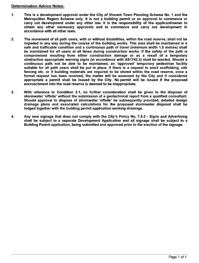
That Council, in accordance with the provisions of the City of Vincent Town Planning Scheme No. 1 and the Metropolitan Region Scheme, APPROVES the development application for Change of Use from Single House and Bed and Breakfast to Single House, Bed and Breakfast and Eating House at No. 5 (Lot: 30; D/P: 1879) Turner Street, Highgate, in accordance with the plans shown in Attachment 2, subject to the following conditions, with the associated determination advice notes contained in Attachment 4: 1. Use of Premises 1.1. This approval relates to the Eating House including alterations and additions as shown on the plans dated 12 January 2018 and 14 March 2018 only. No other development is subject of this approval; 1.2. The use of the premises shall conform to the City of Vincent Town Planning Scheme No. 1 definition of Eating House; 1.3. A maximum of four ‘dine-in’ patrons of the Eating House are permitted on-site at any one time; 1.4. A maximum of two staff of the Eating House are permitted on-site at any one time; 1.5. Deliveries for the Eating House are not permitted outside of the hours of 8:00am to 5:00pm, Monday to Friday; and 1.6. The hours of operation for the Eating House shall be limited to 6:00am to 9:00pm, Monday to Sunday; 2. Parking 2.1. A Parking Management Plan to the satisfaction of the City shall be submitted to and approved by the City prior to the use or occupation of the development detailing how resident, Bed and Breakfast guests and Eating House staff parking will be managed on site such that parking does not impact on the surrounding residential area. Parking associated with the development shall be managed in accordance with the approved Parking Management Plan; and 2.2. A minimum of one lockable bicycle space and access to end of trip facilities shall be provided on-site for the use of staff; and 3. Stormwater Prior to occupation or use of the development, all stormwater collected on the subject land shall be retained on-site by suitable means to the satisfaction of the City. |
Purpose of Report:
To consider an application for development approval for a change of use from Single House and Bed and Breakfast to Single House, Bed and Breakfast and Eating House at No. 5 Turner Street, Highgate.
Background:
|
Landowner: |
K Sealey & L Tarulli |
|
Applicant: |
K Sealey |
|
Date of Application: |
9 January 2018 |
|
Zoning: |
MRS: Urban TPS1: Zone: Residential R-Code: R80 TPS2: Zone: Residential R-Code: R80 |
|
Built Form Area: |
Transit Corridor |
|
Existing Land Use: |
Residential |
|
Proposed Use Class: |
Eating House – “SA” |
|
Lot Area: |
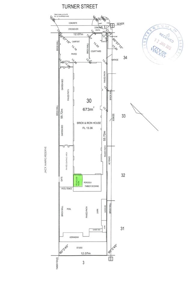
673m² |
|
Right of Way (ROW): |
Not applicable |
|
Heritage List: |
No |
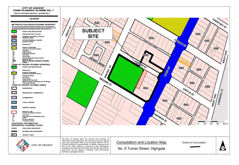
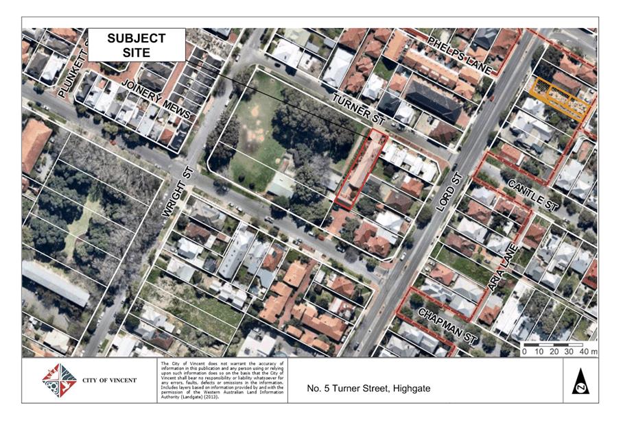
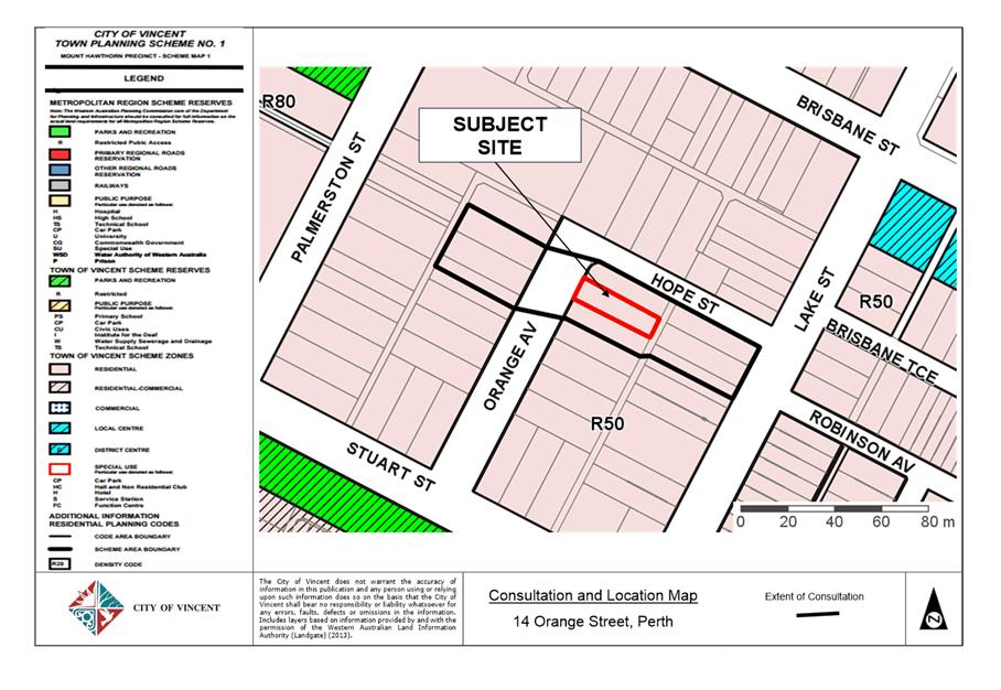
The subject site is located on the southern side of Turner Street, Highgate. The site is adjoined by Jack Mark’s Reserve to the west and residential properties to the north, south and east of the site. The subject site is zoned Residential with a density code of R80 under the City’s Town Planning Scheme No. 1 (TPS1), and the proposed density is not contemplated to change under draft Town Planning Scheme No. 2 (TPS2). The surrounding locality is zoned Residential, with the exception of the area classified as a Reserve, known as Jack Marks Park, immediately to the west of the subject site. The site currently has an approval for use as a Single House and a Bed and Breakfast. The subject site is single storey, with the surrounding developments also mainly single storey, with a few two storey developments in the area. A location plan is included as Attachment 1.
On 12 January 2018, the City received an application for an Eating House on the subject site. The application proposes the continuation of the approved uses of a single house and Bed and Breakfast, and seeks an additional use to operate a kiosk from the subject site. The kiosk use falls within the definition of ‘Eating House’ in TPS1.
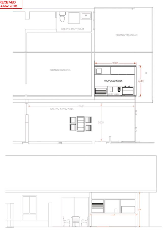
The proposed Eating House is located to the western boundary of the subject site on part of the existing pergola and will operate independently to the bed and breakfast and residential dwelling. The proposed kiosk is 8.044 square metres in size and will accommodate a maximum of two staff. Eating House patrons are proposed to be accommodated in a paved seating area adjacent to Jack Marks Park, with a maximum of four seats. The proposal will require minor alterations and additions to the existing development on site. The development plans are included as Attachment 2.
Details:
Summary Assessment
The table below summarises the planning assessment of the proposal against the provisions of the City of Vincent Town Planning Scheme No. 1 (TPS1), the City’s Policy No. 7.1.1 – Built Form and the State Government’s Residential Design Codes. In each instance where the proposal requires the discretion of Council, the relevant planning element is discussed in the Detailed Assessment section following from this table.
|
Planning Element |
Use Permissibility/ Deemed-to-Comply |
Requires the Discretion of Council |
|
Land Use |
|
ü |
|
Parking & Access |
ü |
|
|
Bicycle Facilities |
|
ü |
Detailed Assessment
The deemed-to-comply assessment of the elements that require the discretion of Council are as follows:
|
Land Use |
|
|
Deemed-to-Comply Standard |
Proposal |
|
Town Planning Scheme No. 1
“P” Use |
Eating House – “SA” Use |
|
Bicycle Bays |
|
|
Deemed-to-Comply Standard |
Proposal |
|
Policy No. 7.7.1 – Parking and Access
1 class one or two bicycle bay 2 class three bicycle bays |
0 bicycle bays |
The above elements of the proposal does not meet the specified deemed-to-comply standards and is discussed in the comments section below.
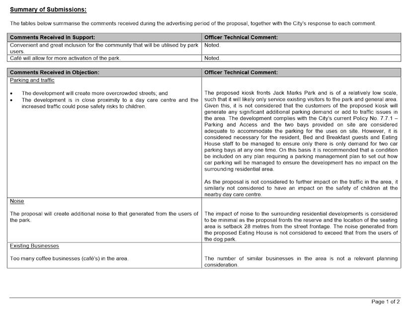
Consultation/Advertising:
Community Consultation was undertaken for a period of 21 days from 20 February 2018 until 13 March 2018. The method of consultation included a sign on site, a notice in a local newspaper, and 16 letters being mailed out to all owners and occupiers adjacent to the site as shown in Attachment 1, in accordance with the City’s Policy No. 4.1.5 – Community Consultation.
At the conclusion of the consultation period, a total of 59 submissions were received by the City with one objection and 58 in support of the proposal.
The key issues raised through the submissions were:
· Parking and traffic from the development will create more overcrowded parking and may pose a safety risk;
· Noise concerns that the proposed opening hours of the café will increase the existing noise issues that stem from the adjacent reserve;
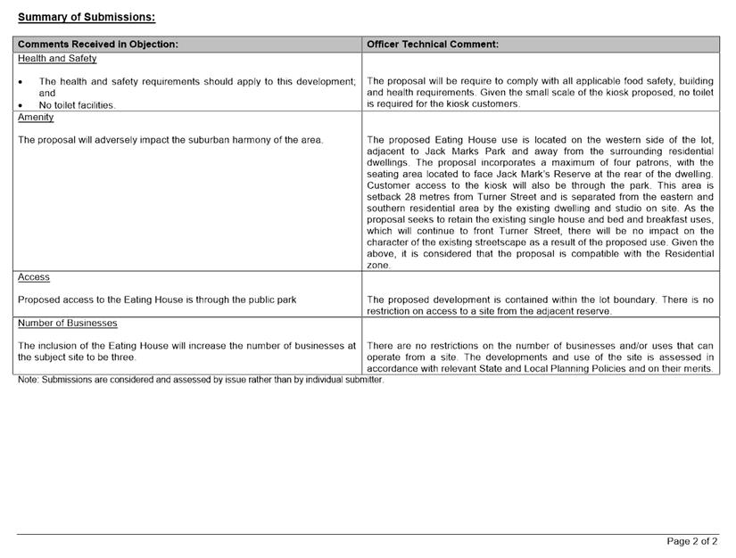
· Health and safety concerns regarding the nature of an eating house use and the lack of toilet facilities;
· Entry to the site through the reserve; and
· The proposed eating house does not fit within the suburban harmony of the area.
A full schedule of submissions including Administration’s response is provided as Attachment 3.
Design Advisory Committee (DAC):
Referred to DAC: No
Legal/Policy:
· Planning and Development Act 2005;
· Planning and Development (Local Planning Schemes) Regulations 2015;
· City of Vincent Town Planning Scheme No. 1 (TPS1);
· State Planning Policy 3.1: Residential Design Codes (R-Codes)
· Policy No. 4.1.5 – Community Consultation;
· Policy No. 7.1.1 – Built Form Policy; and
· Policy No. 7.7.1 – Parking and Access.
In accordance with Schedule 2 Clause76(2) of the Planning and Development (Local Planning Schemes) Regulations 2015 and Part 14 of the Planning and Development Act 2005, the applicant will have the right to apply to the State Administrative Tribunal for a review of Council’s determination.
Draft Town Planning Scheme No. 2
On 8 December 2017, the Acting Minister for Planning announced that the City’s draft Town Planning Scheme No 2 (TPS2) was to be modified before final approval would be granted. The schedule of modifications was confirmed in writing by officers at the Department of Planning, Land and Heritage (the Department). The Department also advised that the modifications to TPS2 would be required before the Acting Minister would finally grant approval to the Scheme. In this regard TPS2 should be given due regard as a seriously entertained planning proposal when determining this application.
Generally the modified version of TPS2 does not impact on the subject property as the zoning will not alter and the land use will be considered a restaurant/café in TPS2. In accordance with Table 1- Zoning table of TPS2, restaurant/café within the Residential zone will become an ‘A’ use, which is a use that requires advertising before Council can exercise its discretion in determining the application. As the application was advertised for community consultation, all of the requirements for TPS2 have been met as part of the processing of this application.
Delegation to Determine Applications:
This application is being referred to Council for determination as the proposal contemplates an ‘SA’ land use and as one or more written objections were received during the community submission period, the application is required to be determined by Council in accordance with the City’s Delegated Authority Register 2017 - 2018.
Risk Management Implications:
It is Administration’s view that there are minimal risks to Council and the City’s business function when Council exercises its discretionary power to determine a planning application.
Strategic Implications:
The City’s Strategic Plan 2013-2023 states:
“Natural and Built Environment
1.1 Improve and maintain the natural and built environment and infrastructure.”
SUSTAINABILITY IMPLICATIONS:
Nil.
Financial/Budget Implications:
Nil.
Comments:
Land Use
An Eating House is a ‘SA’ use within the Residential zone under TPS1. A ‘SA’ use is permitted subject to Council exercising its discretion. The proposal’s scale, location and impact are the key factors to consider when assessing the appropriateness of the use within the Residential zone.
The surrounding context of the site compromises of single houses, grouped dwellings and a local reserve, being Jack Marks Park. The site is bound by the park to the west and residential dwellings to the north, south and east. The proposed Eating House use is located on the western side of the lot, adjacent to Jack Marks Park and away from the surrounding residential dwellings. Customer access to the kiosk will also be through the park.
As the proposal seeks to retain the existing single house and bed and breakfast uses, which will continue to front Turner Street, there will be no impact on the character of the existing streetscape as a result of the proposed use. The additions proposed to accommodate the proposed kiosk include increasing the wall length of the existing dwelling by 3.286 metres under the existing patio roof, and will be setback 3.5 metres from the western lot boundary. The façade fronting the western boundary will include a service window which will assist in mitigating the perception of bulking bulk. The addition is 8.04 square metres in size and is considered minor in nature and given its location and design, will not adversely impact the streetscape or the amenity of the adjacent dwellings or reserve.
The proposed hours of operation being 6:00am to 9:00pm Monday to Sunday are considered appropriate. Given the orientation of the Eating House towards the reserve and away from the residential developments, it is not considered that these hours will have any impact on the surrounding residential properties and will increase the activation and passive surveillance of Jack Marks Park.
Additionally, the proposal incorporates a maximum of four patrons, with the seating area located to face Jack Mark’s Reserve at the rear of the dwelling. This area is setback 28 metres from Turner Street and is separated from the eastern and southern residential area by the existing dwelling and studio on site. This limited number of on-site patrons, is considered to be of a low scale that is compatible with the Residential zone, while providing activation, surveillance and services for the users of Jack Marks Park.
Car Parking
The application has been assessed in accordance with the City’s current Policy No. 7.7.1 Parking and Access and results in the requirement for the Eating House and Bed and Breakfast to provide 0.92 car parking bays. In addition the existing Single House is required to provide one car parking bay under the R‑Codes. As a result, this proposal requires the subject site to provide a total of 1.92 bays, with two bays located on property. At its meeting of 6 March 2018, Council adopted an amendment to its Policy No. 7.7.1 - Parking and Access, which is scheduled to be published and become operational in mid-April. The amendments adopted by Council increased the parking requirements for the proposed Eating House use to one bay. No parking standard was included for the Bed and Breakfast use in the amended Policy, given Bed and Breakfast is an unlisted use under TPS2. Instead the amended Policy requires a parking management plan for Bed and Breakfast proposals.
One submission was received raising concerns regarding the impact the development may have on car parking in the area as there are no additional car bays proposed. The subject site is adjacent to Jack Marks Park which is frequented by many residents and dog owners in the surrounding area. The proposed kiosk fronts the park and is of a relatively low scale, such that it will likely only service existing visitors to the park and general area. Given this, it is not considered that the customers of the proposed kiosk will generate any significant additional parking demand or add to traffic issues in the area. The development complies with the City’s current Policy No. 7.7.1 – Parking and Access and the two bays provided on site are considered adequate to accommodate the parking for the uses on site. However, it is considered necessary for the resident, Bed and Breakfast guests and Eating House staff to be managed to ensure only there is only demand for two car parking bays at any one time. On this basis it is recommended that a condition be included on any plan requiring a parking management plan to set out how car parking will be managed to ensure the development has no impact on the surrounding residential area.
Bicycle Parking
Bicycle parking has been assessed in accordance with the City’s current Policy No. 7.7.1 – Parking and Access, which based on the large size of the publically accessible paved seating area, requires the development to provide one Class 1 or 2 bicycle facilities and two Class 3 bicycle facility, with the proposal providing no bicycle facilities. The amended Policy No. 7.7.1 – Parking and Access, adopted by Council on 6 March 2018, which is scheduled to be published and become operational in mid-April, bases the bicycle parking requirements on the number of persons proposed to be accommodated in the Eating House. Given only four persons are proposed, there is no requirement for bicycle parking under the amended policy.
Given the minimal number of patrons proposed to use the site at any one time and the nature of the business to run as a small kiosk dependent on the business of existing park users, provision of bicycle bays for visitors is not considered necessary, consistent with the City’s intent for the provision bicycle parking. This is particularly the case given access to the development will be through the adjacent reserve which does not provide any footpaths suitable for bicycle access to the kiosk.
However, the development does propose a maximum of two staff for the Eating House, with limited on-site car parking available. Given the requirement for one Class 1 or 2 bicycle facility under the current Policy No. 7.7.1 – Parking and Access, it is considered reasonable to require space for lockable bicycle storage and end of trip facilities on-site for staff in order to encourage alternative means of transport to the subject site, and to mitigate parking issues both on site and within the surrounding area.
Conclusion
The proposed Eating House is considered appropriate within the locality given the proposal is situated so as to orientate towards the reserve and is located away from the surrounding residential properties. The proposal does not significantly alter the existing development with all work contained at the rear of the dwelling and will therefore have no impact on the existing character of the area and streetscape.
The proposal is compliant with the car parking requirements of the City’s current Policy 7.7.1 – Parking and Access and it is considered that parking for the site can be appropriately managed given the alternative forms of transport available, provided bicycle storage is available for staff and a parking management plan is put in place to ensure the demand for parking from the residence, Bed and Breakfast guests and Eating House staff does not exceed the two bays on site. This will ensure there is no impact on the surrounding Residential area.
In light of the above, it is recommended that the development be approved subject to conditions.
5.3 LATE REPORT: No. 14 (Lot: 1; SP: 12592) Orange Avenue, Perth - Second Storey Addition to Single House
TRIM Ref: D18/24816
Author: Stephanie Norgaard, Urban Planner
Authoriser: John Corbellini, Director Development Services
Ward: South
Precinct: 12 – Hyde Park
Attachments: 1. Attachment
1 - Location and Consultation Map ⇩ ![]()
2. Attachment
2 - Development Plans ⇩ ![]()
3. Attachment
3 - Summary of Submissions ⇩ ![]()
4. Attachment
4 - Applicant's Response Submissions ⇩ ![]()
5. Attachment
5 - Determination Advice Notes ⇩ ![]()
|
That Council, in accordance with the provisions of the City of Vincent Town Planning Scheme No. 1 and the Metropolitan Region Scheme, APPROVES the development application for a Second Storey Addition to Single House at No. 14 (Lot: 1; SP: 12592) Orange Avenue, Perth in accordance with the plans shown in Attachment 2, subject to the following conditions, with the associated determination advice notes in Attachment 5: 1. Extent of Approval This approval only relates to the ‘PROPOSED ADDITION’ and ‘PROPOSED UPPER FLOOR’ to Single House shown on the approved plans dated 13 March 2018 and does not relate to the ‘PROPOSED SPA’, ‘TIMBER DECK’, ‘EXTG STUDIO/SHED’ or any other development on the lot; 2. External Fixtures All external fixtures and building plant, including air conditioning units, piping, ducting and water tanks, shall be located so as to minimise any visual and noise impact on surrounding landowners, and shall be screened from view from the street, and surrounding properties to the satisfaction of the City; 3. Stormwater All stormwater produced on the subject land shall be retained on site, by suitable means to the full satisfaction of the City; 4. Schedule of External Finishes Prior to the commencement of development a detailed schedule of external finishes (including materials and colour schemes and details) to the satisfaction of the City shall be submitted to and approved by the City. The development shall be finished in accordance with the approved schedule to the satisfaction of the City prior to the use or occupation of the development; 5. Visual Privacy The windows in the eastern and western elevations of the upper floor bedroom shall be screened or modified to comply with the deemed-to-comply standards of Clause 5.4.1 Visual Privacy of State Planning Policy 3.1: Residential Design Codes to the satisfaction of the City prior to the use or occupation of the development; and 6. General Conditions that have a time limitation for compliance, and the condition is not met in the required time frame, the obligation to comply with the requirements of the condition continues whilst the approved development exists. |
Purpose of Report:
To consider an application for development approval for a Second Storey Addition to a Single House at No. 14 Orange Street, Perth (subject site).
Background:
|
Landowner: |
Derek Bower |
|
Applicant: |
Derek Bower |
|
Date of Application: |
11 December 2017 |
|
Zoning: |
MRS: Urban TPS1: Zone: Residential R Code: R50 TPS2: Zone: Residential R Code: R50 |
|
Built Form Area: |
Residential |
|
Existing Land Use: |
Grouped Dwelling |
|
Proposed Use Class: |
Grouped Dwelling |
|
Lot Area: |
362m² |
|
Right of Way (ROW): |
Yes – 3m wide, drained and sealed |
|
Heritage List: |
No |
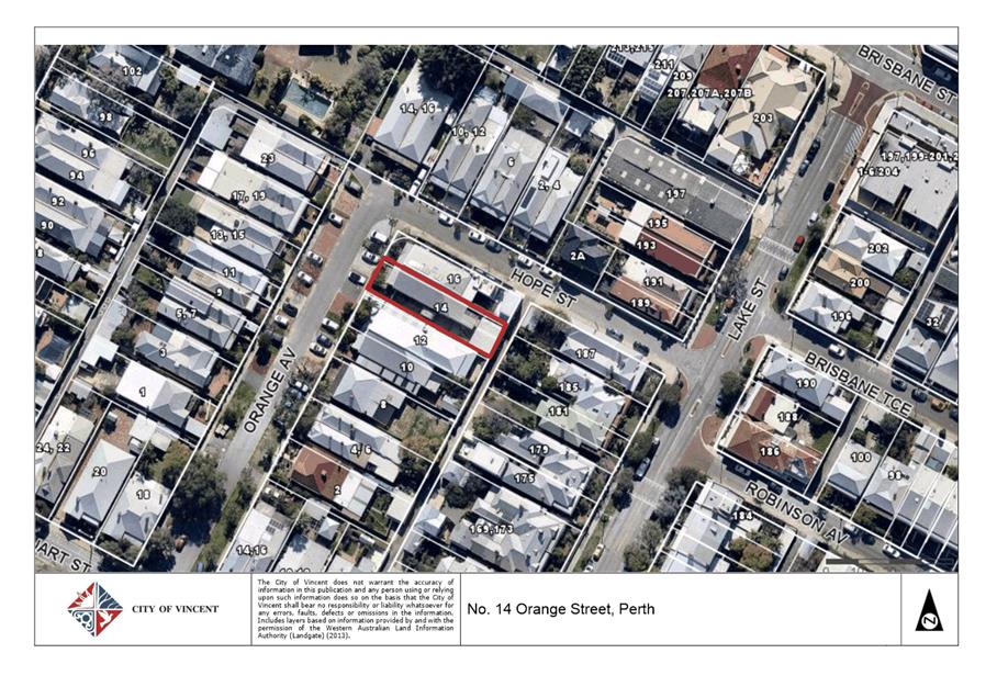
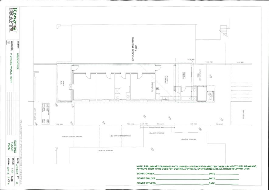
The subject site is located at No. 14 Orange Avenue, Perth, as shown in the location plan included as Attachment 1. The site is bound by Orange Avenue to the west, a ROW to the east and residential properties to the north and south. The subject site comprises of a single storey dwelling, which shares a common wall and roof with No. 16 Orange Avenue.
The locality has been developed with predominantly ‘terrace style’ single storey single houses and grouped dwellings, although there are two storey developments, multiple dwellings and commercial developments within the area. There are a number of Heritage Listed dwellings that front Lake Street, which is located on the adjacent side of the ROW.
The subject site is zoned Residential with a density code of R50 and this is not contemplated to change under draft Town Planning Scheme No. 2 (TPS2). Subject to the City’s Local Planning Policy No. 7.1.1 – Built Form, the site has been identified in the Residential Area and has been assessed against the applicable standards and requirements of the policy.
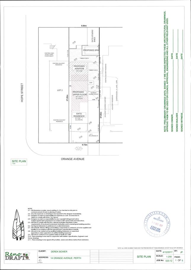
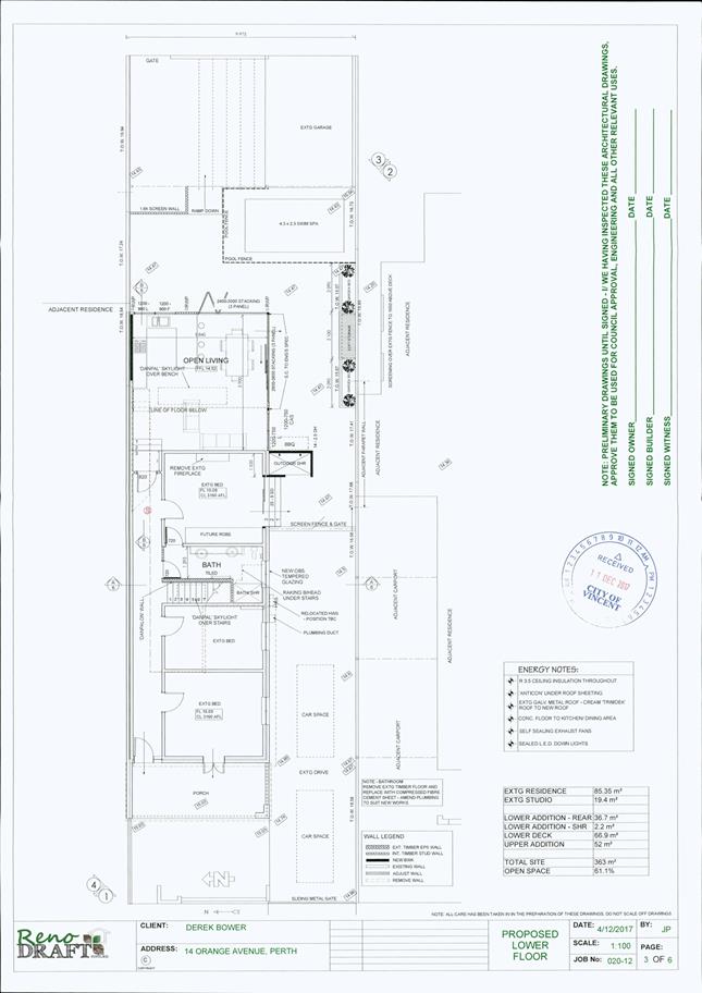
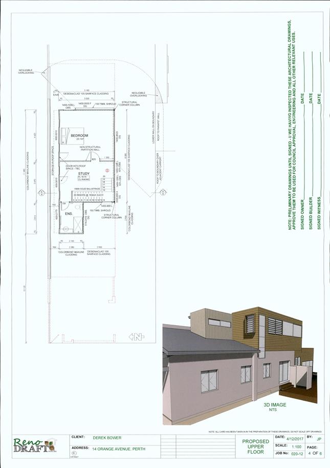
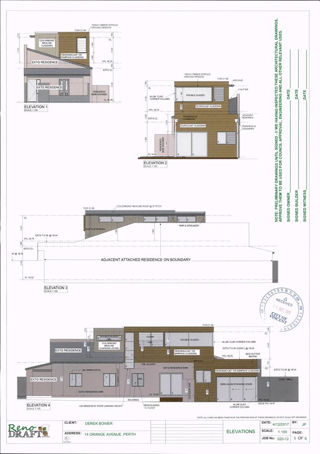
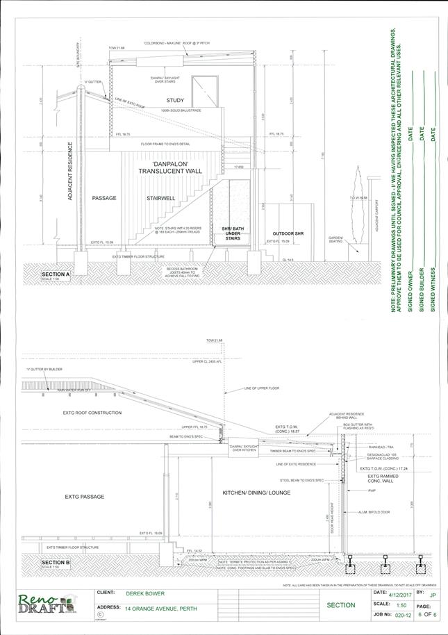
The proposal seeks approval for a second storey addition to the existing dwelling on the subject site. A copy of the applicant’s development plans is included as Attachment 2.
Details:
Summary Assessment
The table below summarises the planning assessment of the proposal against the provisions of the City of Vincent Town Planning Scheme No. 1 (TPS1), the City’s Policy No: 7.6.1 - Heritage Management - Development Guidelines for Heritage and Adjacent Properties, the City’s Policy No. 7.1.1 – Built Form and State Planning Policy 3.1: Residential Design Codes (R-Codes). In each instance where the proposal requires the discretion of Council, the relevant planning element is discussed in the Detailed Assessment section following from this table.
|
Planning Element |
Use Permissibility/ Deemed-to-Comply |
Requires the Discretion of Council |
|
Street Setback |
ü |
|
|
Building Setbacks/Boundary Wall |
|
ü |
|
Building Height/Storeys |
|
ü |
|
Open Space |
ü |
|
|
Outdoor Living Areas |
ü |
|
|
Landscaping |
ü |
|
|
Privacy |
|
ü |
|
Parking & Access |
ü |
|
|
Solar Access |
ü |
|
|
Site Works/Retaining Walls |
ü |
|
|
Essential Facilities |
ü |
|
|
External Fixtures |
ü |
|
|
Surveillance |
ü |
|
|
Impact on Adjacent Heritage Listed Buildings |
ü |
|
Detailed Assessment
The deemed-to-comply assessment of the elements that require the discretion of Council are as follows:
|
Lot Boundary Setbacks |
|
|
Deemed-to-Comply Standard |
Proposal |
|
Clause 5.1.3 of R‑Codes
Southern Boundary Ground Level – Setback 4.8m
Northern Boundary Level One – Setback 1.7m |
Southern Boundary Ground level – Setback 1.7m (shower) and 3.63m (building)
Northern Boundary Level One – Setback 0.9m |
|
Building Height |
|
|
Deemed-to-Comply Standard |
Proposal |
|
Clause 5.6 of Built Form Policy
Max. height to top of external wall (concealed roof) – 7m |
Max. height to top of external wall (concealed roof) – 7.2m |
|
Privacy |
|
|
Deemed-to-Comply Standard |
Proposal |
|
Clause 5.4.1 of R-Codes
Southern Boundary Cone of vision for Major Openings to Bedrooms setback 4.5m from lot boundary
Northern Boundary Cone of vision for Major Openings to Bedrooms setback 4.5m from lot boundary |
Southern Boundary Cone of vision for Major Openings to Bedrooms setback 3.9m from lot boundary
Northern Boundary Cone of vision for Major Openings to Bedrooms setback 3.8m from lot boundary |
The above elements of the proposal do not meet the specified Deemed-to-Comply standards and are discussed in the Comments section below.
Consultation/Advertising:
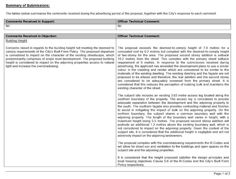
Community consultation was undertaken in accordance with the Planning and Development (Local Planning Scheme) Regulations 2015, for a period of 14 days commencing on 1 February 2018 and concluding on 14 February 2018. Community consultation was undertaken by means of written notifications being sent to surrounding landowners, as show in Attachment 1 and a notice on the City’s website. At the conclusion of the community consultation period, seven submissions were received in objection.
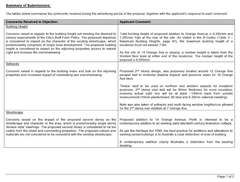
The main issues raised as part of the consultation relate to the:
· Impact of the development on the streetscape;
· Impact of the development on the adjoining properties in terms of bulk and scale;
· Potential use of the development as a short-term rental;
· Unfinished works on the subject site; and
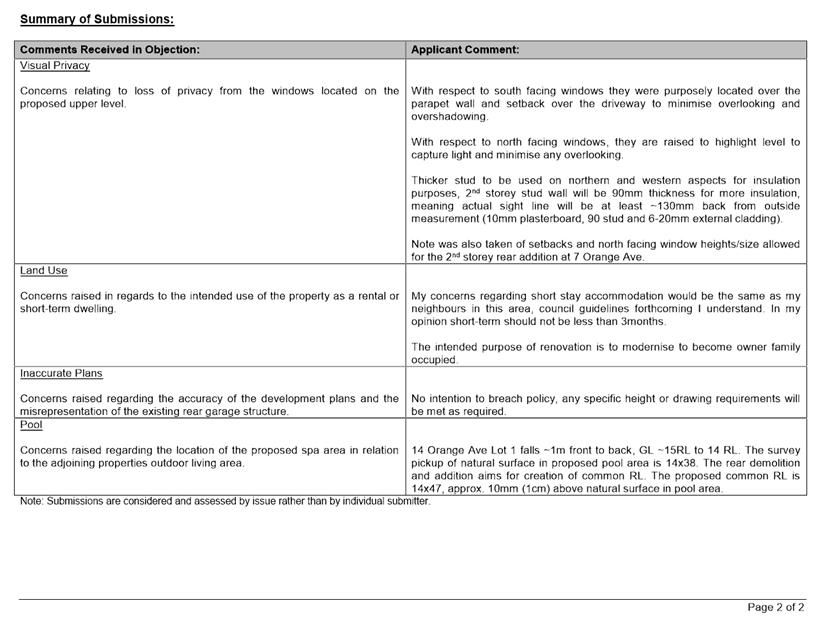
· Potential loss of privacy.
A summary of the submissions and Administration’s comments on each issue raised is included as Attachment 3, with the applicant’s response to the submissions provided in Attachment 4.
Following the advertising period the applicant amended the development application plans to incorporate colours and materials that are considered more consistent with the retained portion of the dwelling.
Design Advisory Committee (DAC):
Referred to DAC: No
Legal/Policy:
· Planning and Development Act 2005;
· Planning and Development (Local Planning Schemes) Regulations 2015;
· City of Vincent Town Planning Scheme No. 1;
· State Planning Policy 3.1 – Residential Design Codes;
· Policy No. 4.1.5 – Community Consultation;
· Policy No. 7.1.1 – Built Form Policy; and
· Policy No: 7.6.1 – Heritage Management - Development Guidelines for Heritage and Adjacent Properties
In accordance with Schedule 2 Clause76(2) of the Planning and Development (Local Planning Schemes) Regulations 2015 and Part 14 of the Planning and Development Act 2005, the applicant has the right to apply to the State Administrative Tribunal for a review of Council’s determination.
Draft Town Planning Scheme No. 2
On 8 December 2017, the Acting Minister for Planning announced that the City’s draft TPS2 was to be modified before final approval would be granted. The Schedule of modifications was confirmed in writing by officers at the Department of Planning, Land and Heritage (the Department). The Department also advised that the modifications to the TPS2 would be required before the Acting Minister would finally grant approval to the Scheme. In this regard the TPS2 should be given due regard as part of the determination of this application. Proposed TPS2 and the modifications required do not impact on the subject property.
Delegation to Determine Applications:
This matter is being referred to Council for determination as the proposal received a total of seven objections during the community consultation period and as a result the application is required to be determined by Council in accordance with the City’s Delegated Authority Register 2017 – 2018.
Risk Management Implications:
It is Administration’s view that there are minimal risks to Council and the City’s business function when Council exercises its discretionary power to determine a planning application.
Strategic Implications:
The City’s Strategic Plan 2013-2023 states:
“Natural and Built Environment
1.1 Improve and maintain the natural and built environment and infrastructure.”
SUSTAINABILITY IMPLICATIONS:
Nil.
Financial/Budget Implications:
Nil.
Comments:
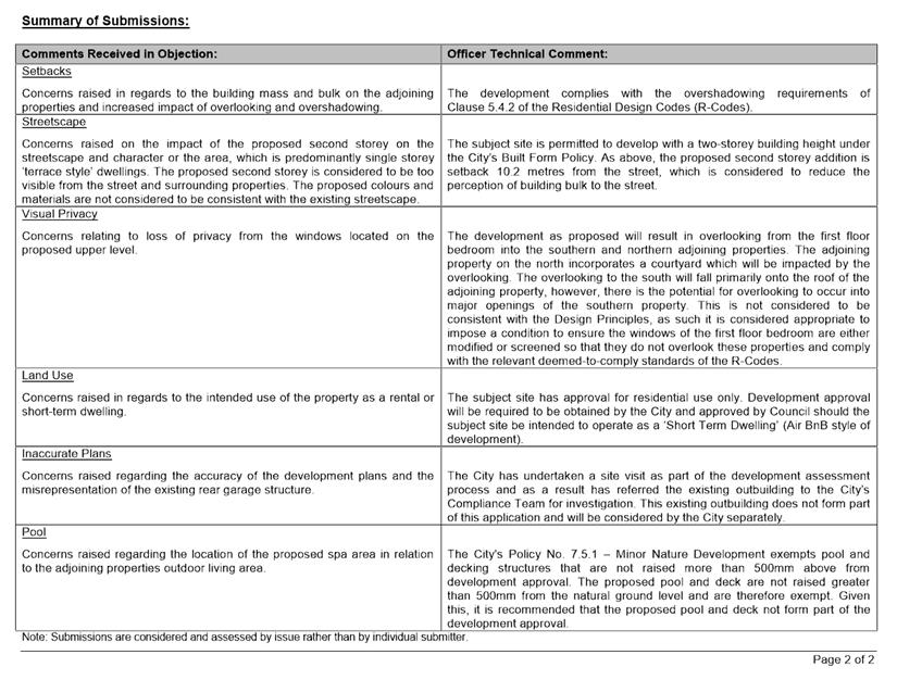
Lot Boundary Setbacks
Northern Boundary
The proposal incorporates a 0.9 metre upper floor setback to the northern boundary in lieu of the deemed-to-comply standard of 1.7 metres. The subject site abuts a residential dwelling which incorporates a shared boundary wall with a maximum height of 5.5 metres. This is considered to screen the majority of the proposed northern wall, which is only 1.2m higher than the existing boundary wall. Furthermore, this wall has been proposed to incorporate cladding which is considered to reduce the perception of building bulk. The northern elevation does not incorporate any major openings and therefore, will not result in a loss of privacy.
Southern Boundary
The proposal incorporates a 1.7 metre and 3.63 metre ground floor setback to the southern boundary in lieu of the deemed-to-comply standard of 4.8 metres. The ground floor development only proposes to modify the layout of the existing building altering the internal layout at the rear of the building, slightly reducing the building foot print and altering the external façade to incorporate major openings. As a result the works are within the existing section of the building the setback of the development is not proposed to change from the existing building line. The proposed alterations incorporates major openings and under the R-Codes this results in an increased deemed-to-comply setback requirement from what is presently required.
The overall building length is slightly reduced, which reduces the bulk of the building on the ground floor. It is not considered that the alteration to the layout and introduction of major openings impacts on the perceived building bulk as previously solid sections of wall are now being amended to incorporate major openings. The existing section of wall comprises rendered material, the proposed works incorporates introduction of horizontal cladding to the rear area which will further reduce the bulk of the ground floor.
Although the ground floor southern boundary elevation contains major openings, the finished floor level of the dwelling does not exceed 0.5 metres above natural ground level and therefore, the proposal complies with the visual privacy requirements of Clause 5.4.1 of the R-Codes. The development will not result in unacceptable overlooking on the adjoining property as a result of the reduced setback. The proposal is also compliant with the overshadowing requirements of Clause 5.4.2 of the R-Codes.
In light of the above, it is considered that the proposal satisfies the design principles and local housing objectives of Clause 5.1.3 and Clause 5.3 of the R-Codes and the City’s Built Form Policy respectively.
Building Height
The proposal exceeds the deemed-to-comply height of 7.0 metres for a concealed roof by 0.2 metres. The existing dwelling on subject site has a wall height of 3.7 metres and ceiling height of 3.1 metres, which restricts the ability to reduce the overall building height of the development and maintain compliant ceiling heights on the upper level. However, the upper level of the development has been setback 10.2 metres from the street, which is considered to reduce the visibility of the development and the impact of the additional building height from the street.
In response to the submissions received during advertising, the applicant has amended the development plans to use a similar colour in the cladding and render which are considered to be similar to the materials of the existing dwelling. It is considered that this will further assist in reducing impact of the addition on the streetscape. The existing dwelling and the façade are not proposed to be altered and therefore, the rear addition and the second storey addition is considered to be adequately screened from the primary street. It is considered that this reduces the perception of building bulk and maintains the existing character of the street.
The subject site includes an existing 3.63 metre access leg located along the southern boundary of the property. The access leg is considered to provide adequate separation between the development and the adjoining property to the south. The southern façade also provides contrasting material and finishes to assist in mitigating the impact of bulk on the adjoining property. On the northern boundary, the subject shares a common boundary wall with the adjoining property. The length of the boundary wall varies in height, with a maximum height being 5.5 metres. The proposed second storey addition will protrude an additional 1.2 metres above the existing boundary wall, which is not considered to impact on the adjoining property. Given the context of the subject site, it is considered that the additional height is negligible and will not adversely impact on the adjoining landowners.
The proposal complies with the overshadowing requirements the R-Codes and will allow for direct sun and ventilation to the buildings and open spaces on the subject site and the adjoining properties.
It is considered that the height proposed satisfies the design principles and local housing objectives Clause 5.6 of the R-Codes and the City’s Built Form Policy respectively.
Privacy
The development as proposed will result in overlooking from the first floor bedroom into the southern and northern adjoining properties. The adjoining property on the north incorporates a courtyard which will be impacted by the overlooking. The overlooking to the south will fall primarily onto the roof of the adjoining property, however, there is the potential for overlooking to occur into major openings of the southern property. This is not considered to be consistent with the Design Principles, as such it is considered appropriate to impose a condition to ensure the windows of the first floor bedroom are either modified or screened so that they do not overlook these properties and comply with the relevant deemed-to-comply standards of the R-Codes.
Conclusion
The proposal requires Council to exercise its discretion in relation to the building height, lot boundary setbacks and visual privacy. Given the context of the subject site, the proposed building heights and lot boundary setbacks are considered to have a negligible impact on the surrounding properties. It is considered that the concerns relating to overlooking can be mitigated through appropriate conditions on development approval. Therefore, it is recommended that the proposal be approved subject to conditions.
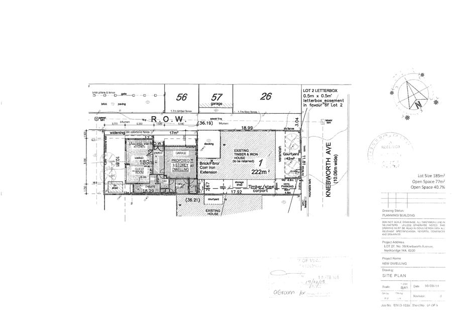
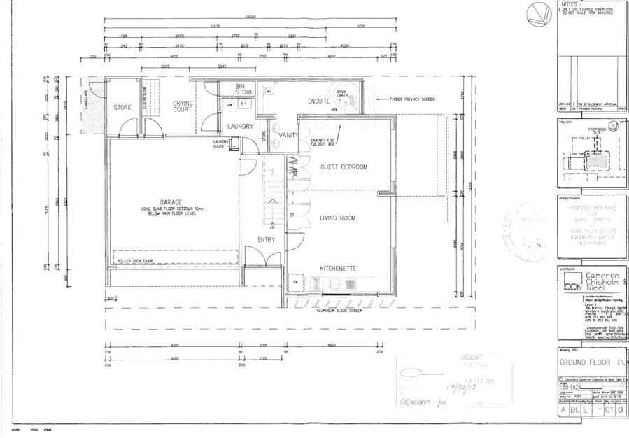
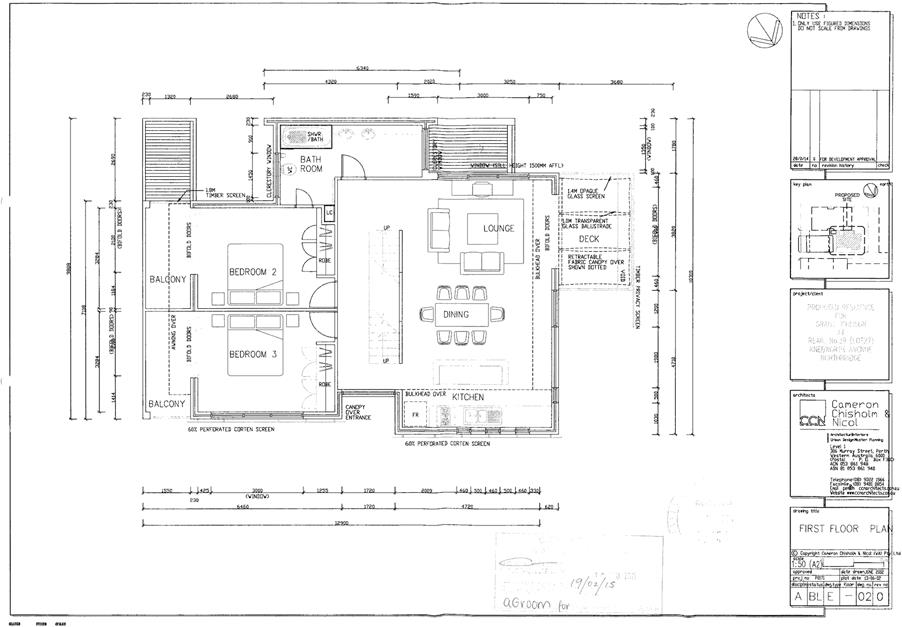
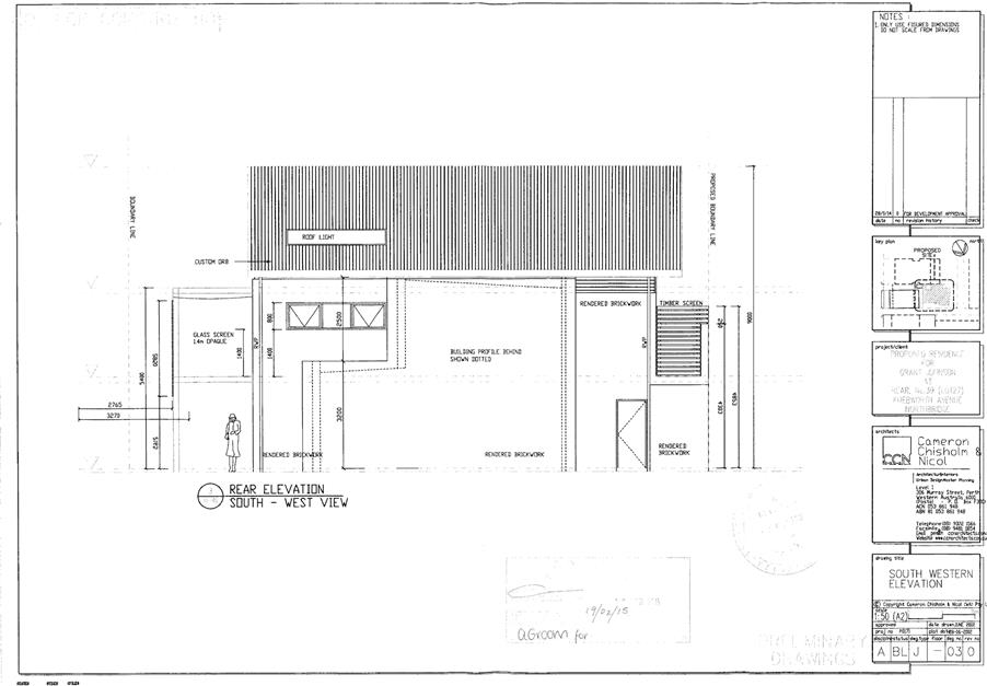
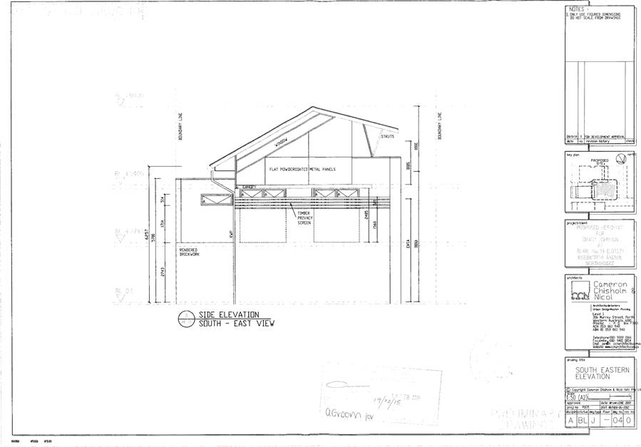
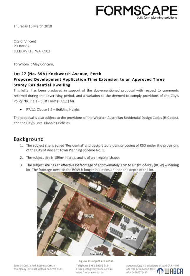
5.4 LATE REPORT: No. 39a (Lot: 2; D/P: 63474) Knebworth Avenue, Perth - Proposed Extension to the Period of Approval: Proposed Construction of a Three-Storey Grouped Dwelling
TRIM Ref: D18/19745
Author: Rana Murad, Senior Urban Planner
Authoriser: John Corbellini, Director Development Services
Ward: South
Precinct: 12 – Hyde Park
Attachments: 1. Attachment
1 - Consultation and Location Plan ⇩ ![]()
2. Attachment
2 - Previous Development Approval Notice and Plans ⇩ ![]()
3. Attachment
3 - Applicants Submission and Response to Schedule of Submissions ⇩ ![]()
4. Attachment
4 - Summary of Submissions ⇩ ![]()
|
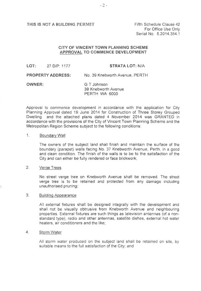
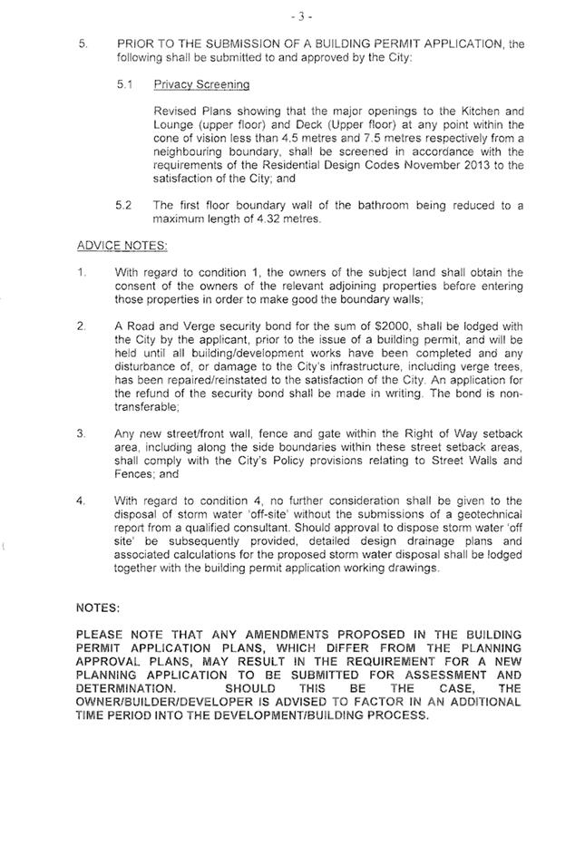
That Council, in accordance with the provisions of the City of Vincent Town Planning Scheme No. 1 and the Metropolitan Region Scheme, APPROVES the application to extend the period within which the development must be substantially commenced at No. 39a (Lot: 2; D/P: 63474) Knebworth Avenue, Perth, for planning approval 5.2014.354.1 granted by Council on 10 February 2015 for Proposed Construction of a Three-Storey Grouped Dwelling subject to the following condition: 1. All conditions, requirements and advice notes detailed on the development approval 5.2014.354.1 granted on 10 February 2014 continue to apply to this approval except as follows: (a) A new condition 6.1 is added to the planning approval as follows: “6.1 Landscape and Reticulation Plan A detailed landscape and reticulation plan for the development site and adjoining road verge shall be prepared to the City’s satisfaction and be lodged with and approved by the City prior to commencement of the development. The plan shall be drawn to a scale of 1:100 and show the following: 6.1.1 The location and type of existing and proposed trees and plants; 6.1.2 The provision of additional deep soil zone and mature tree planting within the outdoor living area of the dwelling to the satisfaction of the City; 6.1.3 Areas to be irrigated or reticulated; All works shown in the approved landscape and reticulation plan shall be undertaken in accordance with the approved plans to the City’s satisfaction, prior to occupation or use of the development and shall be maintained thereafter to the satisfaction of the City;”; and (c) Condition 5 of the planning approval is deleted and replaced with the following condition: “5. Revised Plans Prior to commencement of development revised plans to the City’s satisfaction shall be submitted to and approved by the City showing the first floor boundary wall of the bathroom being reduced to a maximum length of 4.32 metres and screening to the major openings of the Kitchen, Lounge and Deck (Upper floor) that satisfies the deemed-to-comply standards of State Planning policy 3.1: Residential Design Codes. The boundary wall and screening shall be installed in accordance with the approved revised plans to the City’s satisfaction prior to the occupation or use of the development.” |
Purpose of Report:
To consider an application to extend the period within which the development must be substantially commence for planning approval 5.2014.354.1 granted by Council on 10 February 2015 for proposed construction of a three-storey grouped dwelling at No. 39A Knebworth Street, Perth (subject site).
Background:
|
Landowner: |
Grant Johnson |
|
Applicant: |
Grant Johnson |
|
Date of Application: |
18 December 2017 |
|
Zoning: |
MRS: Urban TPS1: Zone: Residential R Code: R50 TPS2: Zone: Residential R Code: R50 |
|
Built Form Area: |
Residential |
|
Existing Land Use: |
Grouped Dwelling |
|
Proposed Use Class: |
Grouped Dwelling |
|
Lot Area: |
188m² |
|
Right of Way (ROW): |
Northern, 3 metres wide, Privately owned with access rights for subject site |
|
Heritage List: |
No. Adjoins a Category B Heritage Listed Dwelling |
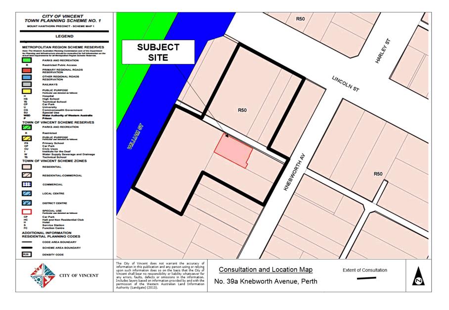
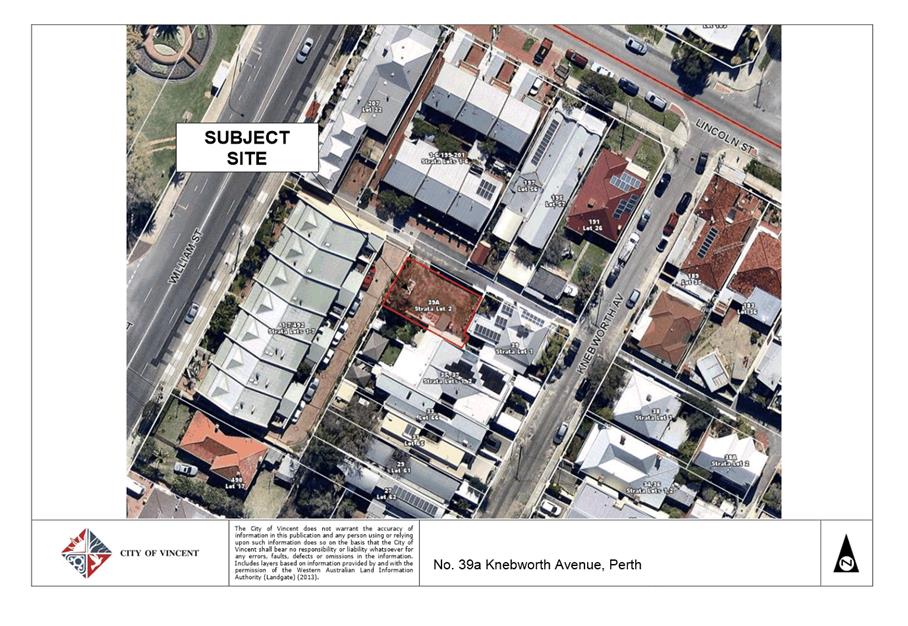
The subject site forms part of a two lot subdivision and fronts onto a ROW to the north. The ROW facilitates access to a number of properties which front onto Lincoln Street. There are currently no existing developments which directly front onto the ROW. The site abuts No. 39 Knebworth Avenue to the east which is heritage listed under the City’s Municipal Heritage Inventory and is classified as a Category B – Conservation Recommended. To the west of the subject site is a strata complex which comprises of seven grouped dwellings fronting onto William Street. To the south is a site containing two grouped dwellings. A location plan in included as Attachment 1.
The subject site and the surrounding lots are zoned Residential and have a density of R50 pursuant to the City’s Town Planning Scheme No. 1 (TPS1). This is not contemplated to change under the City’s Draft Local Planning Scheme No. 2 (LPS2).
At its Ordinary Council Meeting held on 10 February 2015, Council approved subject to conditions the development of a three storey grouped dwelling at the subject site. A copy of the approval notice and the approved plans are included as Attachment 2. The applicant had two years to substantially commence this development however, the development has not been commenced. The applicant has advised that the inability to substantially commence the development was a result of financial difficulties and not obtaining finance. Upon contracting a company to pursue the development approval and obtain a building permit it was noted that a time extension for the development approval would first be required prior to the application for a building permit. The current application seeks a two year extension to the approval period to enable the commencement of the previously approved development. The application does not seek to amend the plans or any other part of the planning approval. The applicant’s justification for the proposed extension is included as Attachment 3.
Details:
Summary Assessment
The table below summarises the planning assessment of the proposal against the provisions of the City of Vincent Town Planning Scheme No. 1 (TPS1), the City’s Policy No. 7.1.1 – Built Form (Built Form Policy) and the State Government’s Residential Design Codes (R-Codes). It notes in each instance where Council previously approved a planning element that required the discretionary of Council as well as each instance where further discretion is proposed. Those elements that were previously approved by Council but which now require discretion under Policy No. 7.1.1 - Built Form (Built Form Policy) are discussed in the Detailed Assessment section following from this table.
|
Planning Element |
Use Permissibility/ Deemed-to-Comply |
Discretion previously applied by Council |
Requires discretion under Built Form Policy |
|
Density/Plot Ratio |
ü |
|
|
|
Street Setback |
|
ü |
|
|
Front Fence |
ü |
|
|
|
Building Setbacks/Boundary Wall |
|
ü |
ü |
|
Building Height/Storeys |
|
ü |
ü |
|
Open Space |
ü |
ü |
|
|
Outdoor Living Areas |
ü |
ü |
|
|
Landscaping |
ü |
|
|
|
Privacy |
|
ü |
|
|
Parking & Access |
ü |
|
|
|
Solar Access |
ü |
|
|
|
Site Works/Retaining Walls |
ü |
|
|
|
Essential Facilities |
ü |
|
|
|
External Fixtures |
ü |
|
|
Detailed Assessment
The deemed-to-comply assessment of the elements that were previously approved by Council but which now require the additional discretion of Council under Policy No. 7.1.1 - Built Form (Built Form Policy) is as follows:
|
Building Height |
|
|
Deemed-to-Comply Standard |
Proposal |
|
Clause 5.6 of Policy No. 7.1.1 – Built Form
Maximum Height - 2 storeys Max. height to top of external wall (roof above) – 6m Max. height to top of pitch – 9m |
Maximum Height - 3 Storeys Max. height to top of external wall (roof above) – 6.3m Max. height to top of pitch – 9.3m |
|
Boundary Setback - Development to Right of Way (ROW) |
|
|
Deemed-to-Comply Standard |
Proposal |
|
Clause 5.31 of Policy No. 7.1.1 – Built Form
1.0m setback to all developments from ROW |
0.7m setback to ROW |
The above elements of the proposal do not meet the specified deemed-to-comply standards and are discussed in the comments section below.
Consultation/Advertising:
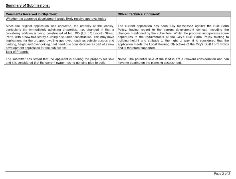
The application was advertised for a period of 14 days in accordance with the Planning and Development (Local Planning Scheme) Regulations 2015, from 8 February 2018 to 21 February 2018. The method of advertising included 22 letters being mailed to all owners and occupiers within close proximity of the subject site, as shown in Attachment 1, in accordance with the City’s Policy No. 4.1.5 – Community Consultation. At the conclusion of the advertising period three submissions were received all of which objected to the proposal. The key concerns raised in the objections related to:
· Impact of the proposal on the amenity of the area; and
· The need for the development to be assessed against the Built Form Policy; and
· The need for the development to be fully reassessed given the changes to the surrounding development context.
(a)
The applicant’s response to the submissions is included in Attachment 3. A summary of the submissions and Administration’s comment on each issue raised is included as Attachment 4.
Design Advisory Committee (DAC):
Referred to DAC: No
Legal/Policy:
· Planning and Development Act 2005;
· Planning and Development (Local Planning Schemes) Regulations 2015;
· City of Vincent Town Planning Scheme No. 1;
· State Planning Policy 3.1 – Residential Design Codes (R-Codes);
· Policy No. 4.1.5 – Community Consultation;
· Policy No. 7.1.1 – Built Form Policy; and
· Policy No. 7.6.1 – Heritage Management – Development Guidelines for Heritage and Adjacent Properties.
The application to amend an approval can be considered in accordance with Schedule 2, Part 9, Clause 77(1)(a) of the Planning and Development (Local Planning Schemes) Regulations 2015 and Clause 77(4) provides the local government the ability to approve the application with or without conditions or refuse the application.
The applicant will have the right to have Council’s decision reviewed by the State Administrative Tribunal (SAT) in accordance with Part 14 of the Planning and Development Act 2005.
The Planning and Development (Local Planning Schemes) Regulations 2015 enables the period within which a development approved must be substantially commenced to be extended. However, no guidance is provided as to how discretion can be exercised in this regard. The State Administrative Tribunal (SAT) has published several decisions that relate to extensions of time to commence development, which provide relevant considerations in the exercise of discretion in this application. Notably in the decision of Claymont Westcapital Pty Ltd and East Perth Redevelopment Authority WASAT 77 – 2008, SAT identified three key considerations, namely whether the:
· planning framework has changed substantially since the development approval was granted;
· development would likely receive approval now; and
· holder of the development approval has actively and relatively conscientiously pursued the implementation of the development approval.
Each relevant matter is to be considered on balance in the exercise of discretion.
Draft Town Planning Scheme No. 2
On 8 December 2017, the Acting Minister for Planning announced that the City’s draft Town Planning Scheme No. 2 (TPS2) was to be modified before final approval would to be granted. The schedule of modifications was confirmed in writing by officers at the Department of Planning, Lands and Heritage (the Department). The Department also advised that the modifications to TPS2 would be required before the Acting Minister would finally grant approval to the Scheme. In this regard the modified version of TPS2 should be given due regard as a seriously entertained planning proposal when determining this application. Generally the modified version of TPS2 does not impact on the subject property.
Delegation to Determine Applications:
This matter is being referred to Council for determination as the proposal incorporates three storeys and is classified as a ‘Category 1’ application.
Risk Management Implications:
It is Administration’s view that there are minimal risks to Council and the City’s business function when Council exercises its discretionary power to determine a planning application.
Strategic Implications:
The City’s Strategic Plan 2013-2023 states:
“Natural and Built Environment
1.1 Improve and maintain the natural and built environment and infrastructure.”
SUSTAINABILITY IMPLICATIONS:
Nil.
Financial/Budget Implications:
Nil.
Comments:
Changes in the Planning Framework
The initial application for the subject site was assessed in accordance with the local planning framework that applied to the site at the time. This planning framework was made up primarily of Town Planning Scheme No. 1, with the City’s local planning policies providing guidance on the assessment of application under this scheme. Town Planning Scheme No. 1 has not changed since the initial application was determined in 2015. The City’s proposed Town Planning Scheme No. 2 also does not impact on the subject site, with both the Residential zone and the applicable R50 density not set to change.
The local planning policies applicable to the site have changed since the application was determined, with the Council formally revoking a number of these local planning policies and adopting the Built Form Policy as a replacement on 13 December 2016. The original proposal incorporated some departures to the deemed-to-comply provisions of the City’s previous local planning policies and the R-Codes. These departures were considered to satisfy the relevant design principles at the time. The current application does not seek to alter any part of the development and the application has been re-assessed using the City’s current Built Form Policy, taking into consideration any changes to the context of the subject site into account. The application requires discretion to be applied in relation to the outdoor living areas, open space, boundary setbacks, privacy, ROW setbacks and building height. The Built Form Policy and changes to the site context did not affect the previous assessment undertaken for the outdoor living areas, open space, boundary setbacks or privacy components of the development. The applicable provisions for these elements did not change as a result of the Built Form Policy and the site context has not altered the assessment. However, elements relating to building height and setback to the right of way, although the provisions are generally aligned with the previous planning framework, are still departures under the current Built Form Policy and warrant further consideration given the changes to the site context. These are discussed in more detail below.
Building Height and Amenity
The City’s Built Form Policy sets a maximum ‘deemed-to-comply’ height for the area of two storeys, with this development incorporating three storeys. The development is proposed to be located on a subdivided lot behind No. 39 Knebworth and cannot be readily seen from the primary street. The proposed development will front and have access from a ROW, which is also the primary frontage for a number of other dwellings.
The proposal has been developed with a range of materials and finishes which are considered to be sympathetic to the locality. The proposal incorporates timber, render and cladding which are materials that are apparent in the area and the design incorporates multiple articulations in order to minimise the built of the development. It is considered that the design of the proposed dwelling minimises the impact of building bulk and scale on the locality. The development addresses the ROW and includes a number of articulations which are considered to enhance the visual character of the streetscape. Given the development will not be readily visible from the surrounding streets, and the presentation to the ROW, it is considered that the proposal will not adversely impact on the amenity of the locality.
It should be noted that the development includes timber slats to the first floor major openings, which combined with an appropriate condition that ensures these act as screening devises, will ensure there is no overlooking into the adjoining properties. Furthermore, the proposal is complaint with the overshadowing requirements of the R-Codes.
Setback to the ROW
The proposed development is the first property within the immediate locality facing the right of way. The surrounding dwellings fronting Lincoln Street, Knebworth Avenue and William Street use the right of way to access their parking areas. The properties fronting both Knebworth Avenue and William Street have their side boundaries built up to the boundary of the right of way. Whereas the garages and carports of the properties fronting Lincoln Street are setback between 1.0 metres and 4.0 metres from the right of way to allow access and ensure manoeuvrability, the proposed 1.5 metre front setback for this development maintains the average setback of the surrounding properties, whilst creating a unique streetscape appearance along the ROW.
Landscaping
The City’s Built Form Policy sets out a deemed-to-comply standard of 15 per cent deep soil zone and 30 per cent canopy coverage at maturity for the development. The application proposes one per cent of the site as deep soil zone, and one per cent canopy coverage. There is an opportunity to increase the deep soil zones and canopy within the outdoor living area and as a result a condition is recommended accordingly.
Modifications to Conditions
A review of the conditions outlined on the previous approval identified a number of improvements that should be made to the wording to ensure they can be applied as intended. This includes the condition relating to visual privacy to ensure that the visual screening which has been noted on the development plans complies with the deemed-to-comply requirements of the R-Codes and is installed in accordance with the approved plans.
Conclusion
The applicant to seek an amendment to a development approval to extend the period of time within which they can substantially commence the development. It is considered that the applicant has actively pursued the development by attempting to gain finance and contracting a company to obtain a building permit. The planning framework applicable to the subject has not changed substantially since the planning approval was issued, given the zoning and density applicable to the subject site remains the same. The proposal has been assessed against the current planning framework and it is considered that the development would likely receive approval under the new policy framework. Given the above, and that the proposal has not been changed since it was previously considered by Council, it is recommended that the application be approved subject to conditions.
8.2 LATE REPORT: Petition to Exclude Brisbane Terrace, Perth from New Parking Zone 7 - Parking Permits Policy No. 3.9.3
TRIM Ref: D18/40405
Author: Steve Butler, Manager Community Safety
Authoriser: Michael Quirk, Director Community Engagement
Attachments: 1. Attachment
1 - Residential Parking Zones ⇩ ![]()
2. Attachment
2 - Aerial view of Brisbane Terrace ⇩ ![]()
|
That Council: 1. NOTES that initial parking occupancy surveying conducted on Brisbane Terrace, Perth does not fully reflect the concerns raised by residents through the petition received at the Ordinary Council Meeting on 6 March 2018; and 2. REQUESTS that a further report on this matter be presented to the Ordinary Council Meeting on 29 May 2018 following the completion of more detailed parking occupancy surveying over a one month period. |
Purpose of Report:
To consider a petition requesting that Brisbane Terrace, Perth be exempt from Residential Parking Zone No. 7 through the introduction of Resident Only Parking after 6pm Monday to Friday and on weekends.
Background:
A petition titled ‘Protest Against Changes to Parking Permit Policy 3.9.3’ containing 22 signatures was received at the Ordinary Council Meeting on 6 March 2018. The petition states:
“We, the Residents of Brisbane Terrace, Perth, request that the City of Vincent reviews the recently introduced Parking Permits Policy No. 3.9.3. We are in the newly created ZONE 7 PARKING PERMIT AREA. This new policy is disadvantaging residents in our street because we now have any Zone 7 residents able to park in our street which is very close to shops, restaurants, bars and cafes in William Street.
We are no having difficulty parking in our own street after 6pm and on weekends. The street parking is now at full capacity at night and on weekends. If we need to park in another street at night, it means walking in the dark back to our homes. This is not acceptable. It is not safe and certainly not in the best interests of Brisbane Terrace residents.
We fought long and hard to get Resident Only Parking Permits for our street. That system worked very well. The street is short, narrow and only has parking on one side. We simply do not have the street parking space to accommodate other City of Vincent residents. We are asking that Brisbane Terrace be EXEMPT from the new Zone 7 and reverts to Resident Only Parking after 6pm and on weekends.”
Details:
Council Policy No. 3.9.3 – Parking Permits
Policy No. 3.9.3 – Parking Permits provides guidance on the issue and control of Parking Permits that may be issued in accordance with the Parking and Parking Facilities Local Law. At the Ordinary Council Meeting on 27 October 2015 it was resolved to initiate a review of this Policy with a view to providing a simpler, more streamlined and contemporary approach to parking control and the issuing of permits. An extensive review was undertaken which recognised that Vincent faces increasing car parking and traffic management challenges associated with population growth and residential density increases. The review also recognised that managing resident perceptions and expectations are a considerable challenge as while inner-City living has an array of benefits there are also associated constraints such as limited supply of on-street parking spaces.
A draft revised policy was authorised for public comment at the Ordinary Council Meeting on 5 April 2016. Public comment included correspondence to all existing permit holders, notices within the Guardian and Perth Voice, and a detailed Information Sheet on the City’s website. A total of 51 submissions were received and considered. Subsequently, at the Ordinary Council Meeting on 20 September 2016 it was resolved to adopt the revised Policy No. 3.9.3 – Parking Permits. A number of changes were introduced through the revised policy to provide greater flexibility to residents and reduce administrative resources required to issue parking permits. Key components of the revised policy include:
· A single ‘Residential Parking Permit’ rather than separate residents and visitors permits;
· Residential Parking Permits being valid for three years and reissued automatically rather than residents needing to reapply on an annual basis;
· Residential Parking Permits being associated with a property rather than a person to enable permits to more easily be transferred to new tenants or new owners as required;
· The maximum number of Residential Parking Permits that will be issued is three for single houses (detached), two for grouped dwellings (town houses), and one for multiple dwellings (apartments). Although some grouped and multiple dwellings will be subject to a specific Development Approval condition which states they will not receive parking permits;
· Residents being entitled to receive the specified number of Residential Parking Permits regardless of the amount of off-street parking that may available on their property.
This revised policy has been in effect since October 2016 with any existing Residential Parking Permits transitioned to these new arrangements upon expiry. There are currently 3,433 permits allocated to residents throughout Vincent compared to 1,663 under the previous policy.
Residential Parking Zones
While the issuing a Residential Parking Permit does not guarantee an on-street parking space or an entitlement to park on any particular street it is acknowledged that the demand for on-street parking continues to increase. When adopting the revised Parking Permits Policy it was recognised that the allocation of three permits to each single house and two permits to a grouped dwelling where parking restrictions apply may lead to a situation where more permits are issued than on-street bays are available. It was also recognised that this may lead to resident vehicles being displaced to adjacent and surrounding streets. During the revised Parking Permit Policy public comment process a number of respondents raised concerns that allocating permits to all eligible residences regardless of their off-street parking availability would increase street congestion and would be detrimental to existing parking options in already congested areas.
In response, Administration recommended that the revised policy enable the establishment of ‘Residential Parking Zones’ whereby each zone would include the streets within a logical urban precinct framed by major roads. These zones would assist residents that reside in streets with limited on-street parking availability and enable flexibility during peak times when the number of residents seeking to park a vehicle on their street exceeds the number of on-street bays. As a result, the current Parking Permits Policy states the following:
“2.1 Residential Parking Permit
a. Property owners with a parking restriction in their street will be issued with this Permit to allow residents and visitors to park on their street or streets within their Residential Parking Zone area, as designated by the City, beyond the prescribed time limit restriction.”
A total of nine Residential Parking Zones (refer to Attachment 1) were determined primarily through the consideration of major roads but also suburb boundaries, public amenities and activity centres. Importantly, the above-mentioned clause within the Policy allows flexibility for Administration to vary these Residential Parking Zones subject to any unanticipated issues or opportunities for improvement.
With an increased number of complaints throughout 2017 regarding on-street parking congestion within residential streets and inability for residents to park on the street where their permit applies it was determined appropriate to implement these zones. Formal implementation of the zones commenced in February 2018 and was also aligned with the City-wide roll-out of new Residential Parking Permits. These electro-static permits are easier to transfer between vehicles to allow for usage by visitors as well as handover between owners and tenants. In addition, these new permits include a QR code which in combination with upgraded parking infringement devices enable the City’s Rangers to more effectively identify expired, cancelled or revoked permits.
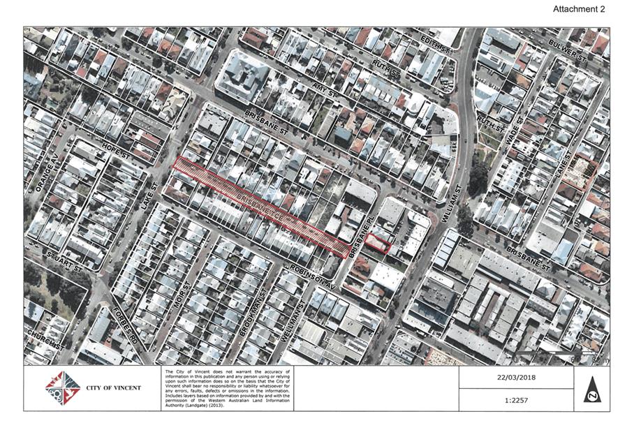
Brisbane Terrace Assessment
Brisbane Terrace is located in the suburb of Perth (refer to Attachment 2). It is approximately 190 meters in length and currently comprises 19 residences including 10 single houses, two duplexes and a block of seven town houses. There are also two vacant, undeveloped blocks on the street. While individual on-street parking bays are not line marked the street has provision to accommodate approximately 23 vehicles. There are currently 38 Residential Parking Permits allocated to residents on Brisbane Terrace with one residence yet to apply for any permits. Brisbane Terrace is located within Residential Parking Zone No. 7 with the boundaries being Newcastle Street, Fitzgerald Street, Vincent Street and Beaufort Street.
Residents are entitled to permits due to the following restrictions being in place:
· ‘No Stopping’ along the entire southern side of the street
· 2P between 8am and 6pm Monday to Friday on the northern side of the street. Permit holders excepted
Essentially any motorist can park on the northern side of Brisbane Terrace for two hours between 8am and 6pm during the week. After 6pm and on weekends only those with a valid Residential Parking Permit can park on the street. It is important to note that Brisbane Terrace does not have a ‘Resident Only’ restriction as referred to within the petition.
The ‘No Stopping’ restriction on the southern side of Brisbane Terrace is due to the relatively narrow street width (less than 6 metres) as well as Right of Way access and rear access for residences located on Robinson Avenue.
Overall, it is acknowledged that there is currently more Residential Parking Permits allocated to Brisbane Terrace residents than there is available on-street parking bays. This situation is exacerbated by an entire side of the street being ‘No Stopping’ at all times. Based on the existing parking restrictions demand for on-street bays may be generated by any motorist 8am and 6pm Monday to Friday, and this has not changed with the introduction of the Residential Parking Zones. Demand for on-street bays after 6pm Monday to Friday and on weekends will be generated by Brisbane Terrace residents and may now also included other Residential Parking Zone No. 7 holders, including those residing on Robinson Avenue with direct rear access to Brisbane Terrace.
Brisbane Terrace Occupancy
Upon review, the petition solely raises concerns regarding the Residential Parking Zones and does not raise any other concerns or issues relating to the Parking Permits Policy. The petition associates the implementation of Residential Parking Zones with specific concerns regarding on-street parking availability on Brisbane Terrace, including:
· “We are now having difficulty parking in our own street after 6pm and on weekends”;
· “The street parking is now at full capacity at night and on weekends”;
· “We simply do not have the street parking space to accommodate other City of Vincent residents”.
In order to determine the extent of these issues the City’s Rangers assessed on-street parking occupancy over the period 9 March to 18 March 2018, and identified the following:
|
Date |
Time |
Vehicle Count |
Occupancy 23 bays = 100% |
Comments |
|
Friday 9 March |
9.00pm |
18 |
78% |
|
|
Saturday 10 March |
8.00am |
12 |
52% |
|
|
1.00pm |
14 |
61% |
|
|
|
5.00pm |
14 |
61% |
2 infringements (no Permit) |
|
|
9.00pm |
17 |
74% |
|
|
|
Sunday 11 March |
8.00am |
12 |
52% |
|
|
1.00pm |
14 |
61% |
|
|
|
5.00pm |
12 |
52% |
1 infringements (no Permit) |
|
|
9.00pm |
17 |
74% |
|
|
|
Monday 12 March |
8:00am |
8 |
35% |
|
|
5.00pm |
16 |
70% |
|
|
|
9.00pm |
18 |
78% |
|
|
|
Tuesday 13 March |
8.00am |
10 |
43% |
2 infringements (park - contrary to signs) |
|
1.00pm |
15 |
65% |
|
|
|
5.00pm |
12 |
52% |
|
|
|
9.00pm |
19 |
83% |
|
|
|
Wednesday 14 March |
8.00am |
8 |
35% |
|
|
5.00pm |
13 |
57% |
|
|
|
9.00pm |
17 |
74% |
|
|
|
Thursday 15 March |
8.00am |
8 |
35% |
4 infringements (park - prohibited period) |
|
5.00pm |
11 |
48% |
|
|
|
9.00pm |
13 |
57% |
|
|
|
Friday 16 March |
8.00am |
7 |
30% |
|
|
5.00pm |
11 |
48% |
|
|
|
9.00pm |
18 |
78% |
|
|
|
Saturday 17 March |
8.00am |
10 |
43% |
7 infringements (park - prohibited period) |
|
1.00pm |
12 |
52% |
|
|
|
5.00pm |
14 |
61% |
|
|
|
9.00pm |
19 |
83% |
|
|
|
Sunday 18 March |
9.00am |
12 |
52% |
7 infringements (park - prohibited period) |
|
12.00pm |
17 |
74% |
|
|
|
7.00pm |
19 |
83% |
|
|
|
AVERAGE |
13.6 |
59% |
23 Infringements issued |
|
Based upon this occupancy the survey the following trends have been identified:
· Average occupancy during the day (8am to 5pm) is 52% leaving an average of 11 bays available
· Average occupancy during the evening (after 5pm) is 72% leaving an average of 7 bays available
· Average occupancy when parking restrictions are in place (between 8am and 6pm Monday to Friday) is 47% leaving an average of 12 bays available
· Average occupancy when resident only permit restrictions are in place (after 6pm Monday to Friday and on weekends) is 63% leaving an average of 8 bays available
· At no time when the surveying took place was the Brisbane Terrace on-street parking fully occupied.
While the City does not have occupancy statistics prior to implementation of the Residential Parking Zones the survey data demonstrates that, as identified by the petitioners, it is likely to be more difficult for Brisbane Terrace residents to locate parking on their street after 6pm and on weekends. Although based on the surveying at no time were the on-street bays at full capacity so the data does not substantiate the petitioners concerns that “street parking is now at full capacity at night and on weekends” and that “we simply do not have the street parking space to accommodate other City of Vincent residents.”
Given the peaks in parking occupancy after 6pm Monday to Friday and on weekends it is possible that residents from throughout Residential Parking Zone No. 7 are parking in Brisbane Terrace to access entertainment and hospitality businesses on William Street. Although it is also possible that these peaks align with Brisbane Terrace residents being at home, and under the Residential Parking Permit Zone No. 7 these peaks may also align with Robinson Avenue residents being at home.
It is acknowledged that the occupancy data only provides a snapshot of Brisbane Terrace on-street parking usage and may not necessarily reflect the full extent of issues being experienced by residents. It is recommended that Administration undertake further occupancy surveying including analysis of where valid permit holders reside to better determine the extent to which the implementation of Residential Parking Zones may (or may not) have contributed to the current concerns. To ensure consistency Administration will apply the same methodology utilised for the North Perth Town Centre parking occupancy surveys, that being the completion of surveying across multiple days and times over a four week period in order to determine midweek and weekend occupancy rates, and that information will then directly inform any parking restriction proposals.
This survey data will then be presented back to the Ordinary Council Meeting in May 2018 given that these parking issues may be having an immediate, negative impact on residential amenity and community safety for the Brisbane Terrace residents.
Brisbane Terrace Options
Administration considers that the Residential Parking Zones remain a key element to ensure the successful management of Residential Parking Permits in accordance with Policy No. 3.9.3. It is expected that the demand for such permits will continue to increase particularly with the necessary introduction of new parking restrictions such as those in the North Perth Town Centre. It remains important that Council and Administration acknowledge and respond to any issues created through the Residential Parking Zones or Policy No. 3.9.3 more broadly.
The initial occupancy data for Brisbane Terrace does not currently justify the street being exempt from Residential Parking Zone No. 7 through the introduction of Resident Only Parking after 6pm Monday to Friday and on weekends. However should further, more detailed occupancy surveying better substantiate concerns raised by the petitioners then there are a number of options that may then be considered:
1. Resident Only Parking Restrictions – Specified Criteria
Maintain the Residential Parking Zones but establish specific, robust criteria as the basis for considering Zone Exempt Streets whereby only vehicles displaying a valid permit for that street would be permitted to utilise on-street parking. This criteria could then be applied to Brisbane Terrace and any other similar requests that may be received in the future. The criteria may include the length and width of the road, available on-street bays versus number of permits issued, proximity to a specific land use or activity type, prevalence of specific restrictions causing additional disadvantage such as ‘No Stopping’ along one side of the road, and/or average on-street occupancy above a designated percentage.
2. Amended Residential Parking Zones
Policy No. 3.9.3 states that permits allow residents to park on their street or streets within their Residential Parking Zone area as designated by the City. Administration acknowledges that while these zones have been established based upon logical urban precincts there remains a need to review their effectiveness. It is for that reason the specific extent and boundaries of these zones were not included within the policy.
An option may be the creation of an additional number of smaller zones which then limits the number of surrounding streets on which a resident may park although this approach will inevitably create a larger number of zone boundaries which may be more difficult for residents to interpret and and also more difficult for the City’s Rangers to enforce. Another option may be to remove Town Centres and immediately adjacent streets from the existing zones. This will prevent the ability for residents to drive and park as close as possible to an activity centre that falls within their zone. Those residences within Town Centres will still need to be granted the ability to park so in effect additional zones most likely comprising Exempt Streets (as per the option above) will be established. It should be noted that permits do not authorise parking in 15/30 minute parking bays and ticket machine zones.
3. Change Existing Brisbane Terrace Parking Restrictions
Given the somewhat unique characterisitics of Brisbane Terrace it may be justifiable to simply introduce ‘Resident Only Parking’ after 6pm Monday to Friday and on weekends to relieve issues raised by residents. Upon initially reviewing the petition Administration was symptehtic to these unique characteristics, however a recommendation to simply change the existing parking restrictions and Residential Parking Zone No. 7 is difficult given the initial occupancy survey data.
Nonetheless, an immediate change to the existing parking restrictions to restrict on-street parking to permit holders only residing on Brisbane Terrace remains an opiton. This will provide a solution to the concerns raised within the petition but does necessary not provide the basis for consistent, well-informed decision making moving forward.
4. No Change
Both Council and Administration have recognised that increasing density and activity has led to a decrease in the availability of on-street parking, and while parking permits enable access for residents and businesses they do not guarantee the availability of a car parking space or entitlement to car parking spaces on any street. The on-street parking challenges being experienced on Brisbane Terrace may simply be regarded as a constraint of inner-City living where alternative transport options are increasingly necessary given the limited supply of on-street parking spaces.
Consultation/Advertising:
Nil.
Legal/Policy:
The City of Vincent Parking & Parking Facilities Local Law 2007 (as amended) regulates the parking or standing of vehicles in all or specified thoroughfares and reserves under the care, control and management of the local government and to provide for the management and operation of parking facilities.
Council Policy No. 3.9.3 – Parking Permits provides guidance on the allocation and control of Parking Permits issued in accordance with the City of Vincent Parking and Parking Facilities Local Law.
Risk Management Implications:
Medium: Implementation and administration of Council Policy No. 3.9.3 – Parking Permits directly impacts parking, traffic management, residential amenity, community safety, Local Law enforcement and corporate reputation.
Strategic Implications:
Effective implementation of the Parking Permits Policy aligns with the following objective within the City of Vincent Strategic Community Plan 2013-2023:
“Natural and Built Environment
1.1.5 Take action to improve transport and parking in the City and mitigate the effects of traffic.”
SUSTAINABILITY IMPLICATIONS:
Nil.
Financial/Budget Implications:
Nil.
Comments:
The revised Policy No. 3.9.3 – Parking Permits has been in place since late 2016 and the simpler, more contemporary approach to parking control has generally been effective although changes to the number of permits that eligible residents are able to receive has increased pressure on on-street parking in several areas. Implementation of the policy has been supported by a number of initiatives including the establishment of Parking Rangers, new rosters and patrol patterns for Parking Rangers, acquisition of more contemporary infringement devices, allocation of new electro-static permits with QR codes, and the establishment of Residential Parking Zones.
With the number of Residential Parking Permits increasing from 1,663 to 3,433 since the revised policy came into effect it is considered that the Residential Parking Zones are an important tool to assist with the management of on-street parking demands. However, the concerns raised by Brisbane Terrace residents through their recent petition has identified that certain streets may be adversely impacted by these Residential Parking Zones particularly where the street is already constrained and in close proximity to an activity centre. The petition submitted by Brisbane Terrace has been objectively considered by Administration, however the initial on-street parking occupancy survey does not support the concerns raised.
It is recommended that Administration undertake further occupancy surveying as a matter of priority and also specifically identify whether other residents from within Residential Parking Zone No. 7 are indeed parking on Brisbane Terrace. This will ensure well-informed decision making in response to the concerns raised thorough the petition and also provide a basis for considering any similar issues raised by residents throughout Vincent.
10 Motions of Which Previous Notice Has Been Given
TRIM Ref: D18/43286
|
1. AFFIRMS its support for addressing climate change within the City of Vincent; 2. CONFIRMS there is a climate emergency that requires urgent action by all levels of government, including by local councils; 3. REQUESTS that the Sustainable Environment Strategy be delivered by March 2019 to support decision making in the 2019/20 Budget and Corporate Business Plan; 4. REQUESTS that the Sustainable Environment Strategy include the following measures: 4.1. Set a target of zero net carbon emissions by a defined date; 4.2. Set a target of zero net carbon emissions from stationary energy by a defined date; 4.3. Include plans to support roll out of electric vehicle fleet or other technology that can achieve zero emissions vehicles within the City of Vincent; 4.4. Include plans to create an electric vehicle fleet or other technology that can achieve zero emissions as part of forward purchasing practice; and 5. REQUESTS that administration give consideration to the carbon emissions which result from the management of waste as part of the current Waste Management Strategy. |
Reason
Climate Emergency
Human induced climate change stands in the first rank of threats to humans, civilisation and other species. WALGA has recently echoed the calls of climate scientists that “we are in a state of climate emergency which requires urgent action” (Draft Climate Change Policy Statement). This draft policy states that ‘Local Government acknowledges:
1. The science is clear: Climate change is occurring now, and human activities are the dominant cause.
2. Climate change threatens human societies and the Earth’s ecosystems.
3. Climate change requires urgent action to mitigate against catastrophic climate change and to adapt to the climate change that is now unavoidable.
4. Mitigation and adaptation strategies must be efficient, effective and equitable.
5. A failure to adequately address this climate change emergency places an unacceptable burden on future generations.’
The International Panel on Climate Change most recent assessment Report (AR5) confirmed that ‘Continued emissions of greenhouse gases will cause further warming and changes in all components of the climate system. Limiting climate change will require substantial and sustained reductions of greenhouse gas emissions’.
Working Group 3 of Assessment Report 5 found that ‘without additional efforts to reduce GHG emissions beyond those in place today, emissions growth is expected to persist driven by growth in global population and economic activities. Baseline scenarios, those without additional mitigation, result in global mean surface temperature increases in 2100 from 3.7°C to 4.8°C compared to pre-industrial levels.’ ‘Delaying mitigation efforts beyond those in place today through 2030 is estimated to substantially increase the difficulty of the transition to low longer-term emissions levels and narrow the range of options consistent with maintaining temperature change below 2°C relative to pre-industrial levels’.
Within the suite of IPCC Representative Concentration Pathways the only scenario which can achieve this outcome is RCP2.6, which is likely keep the climate below 2oC and more unlikely than likely to achieve 1.5oC temperature increase. No Representative Concentration Pathways yet exist which can achieve a 1.5oC. A 2oC temperature increase equates to a global CO2 concentration of 450ppm.
IPCC AR5 Working Group 3 states ‘Mitigation scenarios reaching around 450ppm CO2eq concentrations by 2100 show large-scale global changes in the energy supply sector (robust evidence, high agreement). In these selected scenarios, global CO2 emissions from the energy supply sector are projected to decline over the next decades and are characterized by reductions of 90% or more below 2010 levels between 2040 and 2070. Emissions in many of these scenarios are projected to decline to below zero thereafter’. Below zero emission requires systems which pull CO2 out of the air and then sequester it back into the ground.
The shift required to achieve the scale of reduction of emissions (90% reduction in the next 22+ years) will be the most significant shift in the global energy system in the last 100 years. Because most infrastructure is already built and anything new will be built for a 40+ year timeframe to achieve the types of reductions in emissions requires immediate action for all future infrastructure investments. Further there will need to be early decommissioning of existing assets to achieve the reductions required.
We are facing a climate emergency which requires urgent and immediate action by the City of Vincent as well as all levels of government.
Sustainable Environment Strategy
Recognising the need for urgent action it is appropriate that the City needs to have clear targets to transition the City to a state of zero net emissions as quickly as possible.
Within Vincent the primary sources of emissions for the City and also for our residents are stationary energy emissions, transport emissions and waste emissions.
Stationary Energy Emissions
Stationary energy emission are generated by the combustion of fossil fuels to produce power. The most obvious way to transition to a state of zero net energy emissions is through the installation of renewable energy such as solar power. Currently within WA 1 kW of solar power costs roughly $1000. This solar panel will produce roughly 1950 kWhr’s of electricity per year (assumes 300 days sunshine and 6.5 kWhr per day per panel). With power currently retailing at 28c/kWhr this is $546/year. This investment will pay for itself in two years with the remaining 18 year life of the solar panels able to deliver a net reduction in energy costs. The City of Vincent consumes roughly 1.3 million kWhr of electricity a year. To produce the same amount of power simply from solar panels would require roughly 700 kW or panels (~2800 panels) and an unshaded roof area of approximately 7000 m2. Whilst this is a significant investment once installed and paid for will deliver roughly $1.6 million is cost savings to residents through the reduction in annual electricity costs across the city.
Initial solar installation would offset power consumed during the day in our day time operating assets such as the Administration building, Beatty Park and Depot. Progressively over time this power production will exceed the daytime consumption and will need to be fed back into the grid. With the advent of organisations such as Power Ledger the City of Vincent will be able to sell this excess power to our residents at a discount to the current commercial rate but still be able to fund itself. If the City were to sell our power to residents 18.6c (a 33% reduction to the current commercial rate) the installed panels would still pay for themselves in 3 years and would at the same time reduce cost of living pressure in our community. The power could be potentially targeted at the most vulnerable of our residents.
There would be challenges with implementing a design such as proposed which would take effort to overcome. We would also need to look at addressing power supply challenges in the evening with the growth of the battery storage sector is fast becoming a reality. This proposal is not the ideal option for the city to make this transition, it is simply an example of how it could be done. There will be many more effective methods to achieve this transition but using this example the City could have zero net stationary energy emissions by 2030 by installing 64 kW of power every year for the next 11 years.
The plan would also need to consider supporting our community’s transition from fossil fuel power, which would need to be achieved by education, incentives, community engagement and council policy.
Transport emissions
Transport emissions occur primarily through the combustion of hydrocarbons in vehicles. To transition from combustion engines requires alternative modes of transport such as public transport, bicycles, walking and electric vehicles. There are existing efforts to support transition to these other forms of transportation however there is ultimately still a need for personal vehicle transportation. As such currently the only option to address these emissions is to run electric vehicles powered on renewable energy. The City’s role in this process is two-fold. Firstly to support the provision of public infrastructure in our community to enable recharging of electric vehicles such as providing appropriately located recharge stations across our community and secondly to transition our vehicle fleet to electric vehicles where practical. The City spends roughly $320,000 per year of vehicle fuel a cost saving that can be considered with the decision to transition to electric vehicles. As such it is considered appropriate to consider transition to autonomous vehicles and the installation of appropriate infrastructure such as charging stations across our community as part of the Climate Emergency Plan.
Waste emissions
Waste emissions are primarily caused by the decomposition of organic matter in landfill into methane, which when released from landfill has a 21 times multiplier effect on climate change. Organic matter represents roughly 40% of our waste stream and is a key focus of our existing waste management activities to divert this waste from landfill. The impacts of greenhouse gas emissions from these alternative management approaches vary and it is appropriate to give consideration to the carbon footprint of our alternative technologies as part of the waste strategy. Technologies such as anaerobic decomposition and Biochar are treatment technologies that not only convert the organic matter into a usable fertiliser, they also fix the carbon emissions through the processing process, eliminating the emissions caused by waste decomposition.
Administration Comments
Administration supports the intent of Recommendations 1 and 2 of the Motion. This wording is reflective of the draft Climate Change Policy statement released by WALGA for consultation. The City is currently preparing a submission on this draft Policy that is intended to be presented to Council for consideration at the 1 May 2018 Council Meeting.
In relation to item 3, Administration does not support bringing forward the final adoption date of the Sustainable Environment Strategy to March 2019. There are a number of vital stages to be completed in the development of the Strategy between now and June 2019 (this date supported by Council at a workshop on 11 April 2017). This includes reviewing all related strategies, policies and plans, establishing baseline data in the areas of water, energy and waste against which future measurement and reporting can take place, and the development of appropriate targets, performance indicators and measurement tools. The latter steps in this process will require the expert guidance of a specialist consultant and the budget for this work is included in the 2018/19 financial year. The consultant is intended to be engaged in the first quarter of 2018/19, following adoption of the budget. This work will then inform the content for the Strategy. The Strategy is intended to be put to Council for consideration to adopt for public consultation in early 2019 and the remainder of the financial year will be necessary to complete advertising and report back to Council on the outcomes of this process to finalise the document. It is necessary for each stage in the project to be completed so the full financial year is required to complete this process.
Given that the draft Strategy is planned to be presented to Council for approval to advertise by March 2019, Council will have ample prior opportunity to consider and have due regard to the draft Strategy in its Budget deliberations for 2019/20.
In relation to Recommendation 4, Administration supports the inclusion of net zero emission targets within the Sustainable Environment Strategy. Emission baselines for the City’s stationary power generation, transport and organic waste management can be set out within the Strategy to inform short, medium and long-term emission targets. Specific actions (and funding) to achieve those targets will then need to be incorporated into the Corporate Business Plan and Long Term Financial Plan to facilitate those targets being met. Additionally, strategies for engaging, supporting and incentivising the community’s move toward zero carbon emissions can also be included.
In relation to Recommendation 5, Administration supports consideration of carbon emissions resulting from the management of waste within the Waste Management Strategy that is currently being prepared.