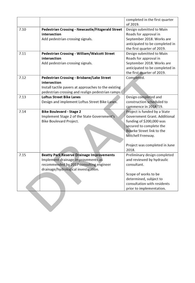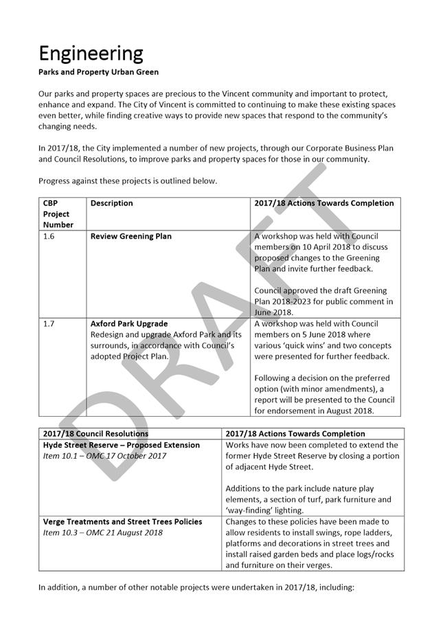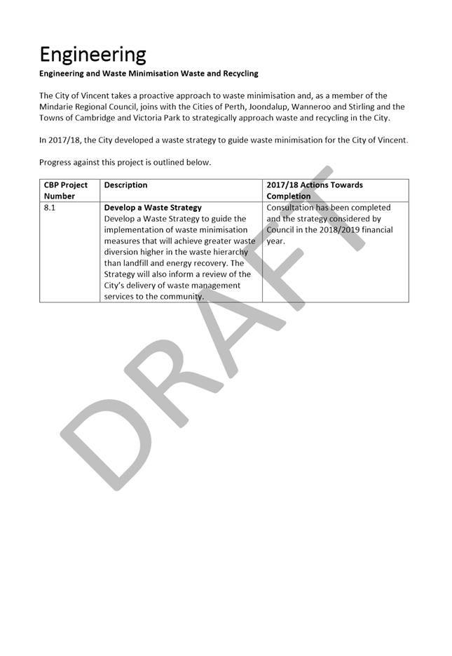
AGENDA
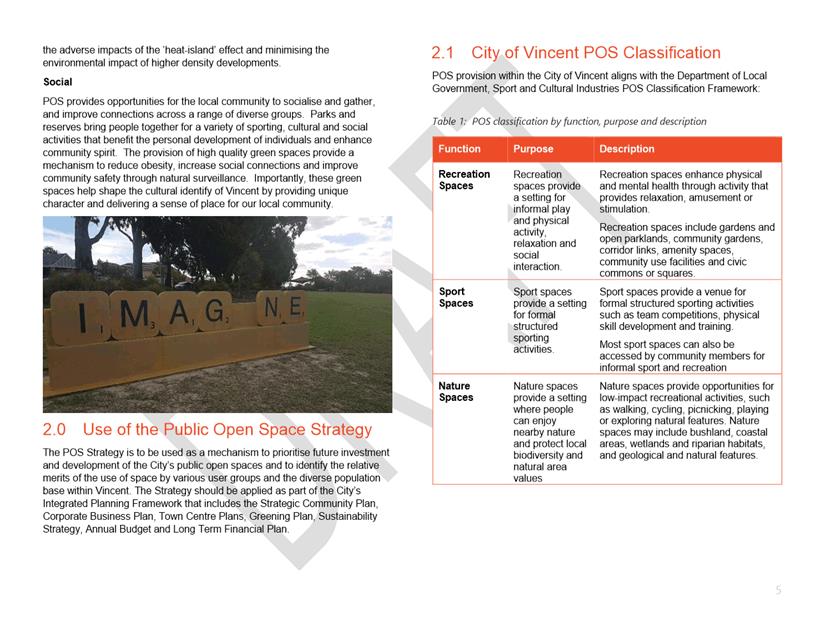
Council Briefing
6 November 2018
|
Time: |
6pm |
|
Location: |
Administration and Civic Centre 244 Vincent Street, Leederville |
David MacLennan
Chief Executive Officer
AGENDA
Council Briefing
6 November 2018
|
Time: |
6pm |
|
Location: |
Administration and Civic Centre 244 Vincent Street, Leederville |
David MacLennan
Chief Executive Officer
Council Briefing Agenda 6 November 2018
DISCLAIMER
No responsibility whatsoever is implied or accepted by the City of Vincent (City) for any act, omission, statement or intimation occurring during Council Briefings or Council Meetings. The City disclaims any liability for any loss however caused arising out of reliance by any person or legal entity on any such act, omission, statement or intimation occurring during Council Briefings or Council Meetings. Any person or legal entity who acts or fails to act in reliance upon any statement, act or omission made in a Council Briefing or Council Meeting does so at their own risk.
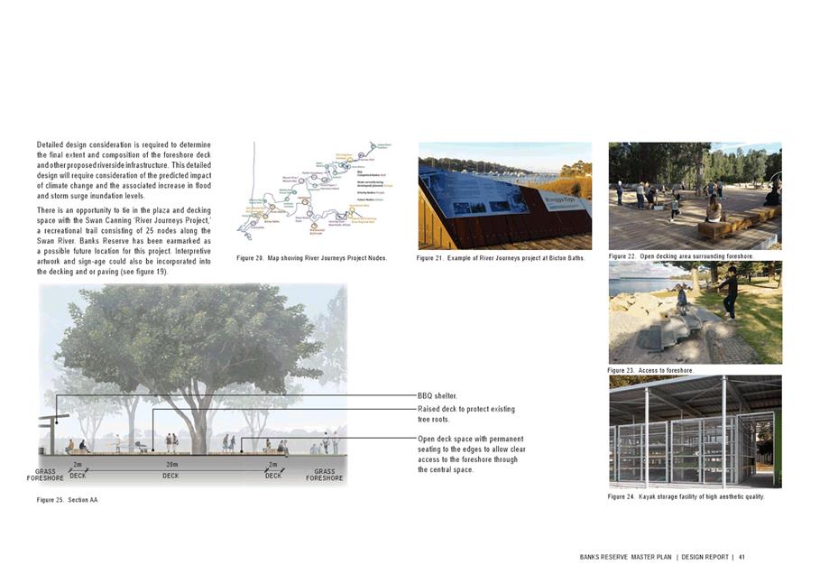
In particular and without derogating in any way from the broad disclaimer above, in any discussion regarding any planning or development application or application for a licence, any statement or intimation of approval made by an Elected Member or Employee of the City during the course of any meeting is not intended to be and is not to be taken as notice of approval from the City. The City advises that anyone who has any application lodged with the City must obtain and should only rely on WRITTEN CONFIRMATION of the outcome of the application, and any conditions attaching to the decision made by the Council in respect of the application.
Copyright
Any plans or documents contained within this Agenda may be subject to copyright law provisions (Copyright Act 1968, as amended) and that the express permission of the copyright owner(s) should be sought prior to their reproduction. It should be noted that Copyright owners are entitled to take legal action against any persons who infringe their copyright. A reproduction of material that is protected by copyright may represent a copyright infringement.
PROCEDURE FOR PUBLIC SPEAKING TIME
The City of Vincent Local Law Relating to Meeting Procedures prescribes the procedure for persons to ask questions or make public statements relating to a matter affecting the City, either verbally or in writing, at a Council meeting.
Questions or statements made at an Ordinary Council meeting can relate to matters that affect the City. Questions or statements made at a Special Meeting of the Council must only relate to the purpose for which the meeting has been called.
1. Shortly after the commencement of the meeting, the Presiding Member will ask members of the public to come forward to address the Council and to give their name and the suburb in which they reside or, where a member of the public is representing the interests of a business, the suburb in which that business is located and Agenda Item number (if known).
2. Public speaking time will be strictly limited to three (3) minutes per member of the public.
3. Members of the public are encouraged to keep their questions/statements brief to enable everyone who desires to ask a question or make a statement to have the opportunity to do so.
4. Public speaking time is declared closed when there are no further members of the public who wish to speak.
5. Questions/statements are to be directed to the Presiding Member and are to be made politely in good faith and are not to be framed in such a way as to reflect adversely or be defamatory on a Council Member or City Employee.
6. Where the Presiding Member is of the opinion that a member of the public is making a statement at a Council meeting, that does not affect the City, he may ask the person speaking to promptly cease.
7. Questions/statements and any responses will be summarised and included in the Minutes of the Council meeting.
8. Where practicable, responses to questions will be provided at the meeting. Where the information is not available or the question cannot be answered, it will be “taken on notice” and a written response will be sent by the Chief Executive Officer to the person asking the question. A copy of the reply will be included in the Agenda of the next Ordinary meeting of the Council.
9. It is not intended that public speaking time should be used as a means to obtain information that would not be made available if it was sought from the City’s records under Section 5.94 of the Local Government Act 1995 or the Freedom of Information (FOI) Act 1992. The CEO will advise the member of the public that the information may be sought in accordance with the FOI Act 1992.
RECORDING AND WEBSTREAMING OF COUNCIL MEETINGS
· All Ordinary and Special Council Meetings are electronically recorded except when the Council resolves to go behind closed doors;
· All recordings are retained as part of the City's records in accordance with the General Disposal Authority for Local Government Records produced by the Public Records Office;
· A copy of the recorded proceedings and/or a transcript of a particular section or all of a Council meeting is available in accordance with Policy No. 4.2.4 – Council Meetings – Recording and Web Streaming.
· Ordinary Meetings of Council and Council Briefings are streamed live on the internet in accordance with the City’s Policy – 4.2.4 - Council Meetings Recording and Web Streaming. It is another way the City is striving for transparency and accountability in what we do.
· The live stream can be accessed from http://webcast.vincent.wa.gov.au/video.php
· Images of the public gallery are not included in the webcast, however the voices of people in attendance may be captured and streamed.
· If you have any issues or concerns with the live streaming of meetings, please contact the City’s Manager Governance and Risk on 08 9273 6538.
Council Briefing Agenda 6 November 2018
1 Declaration of Opening / Acknowledgement of Country
2 Apologies / Members on Leave of Absence
3 Public Question Time and Receiving of Public Statements
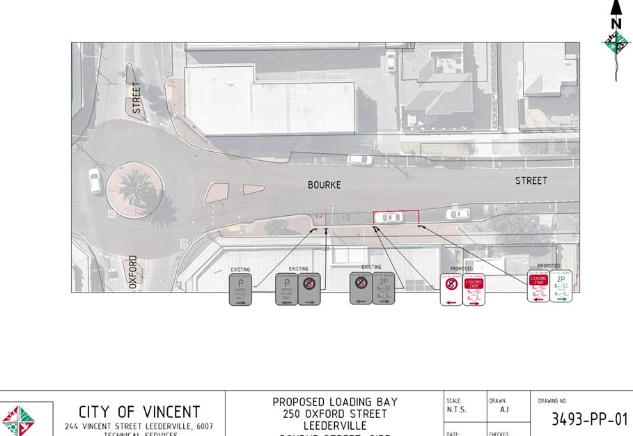
6.1 Minor Parking Restriction Improvements/Amendments
7.1 LATE REPORT: Investment Report as at 31 October 2018
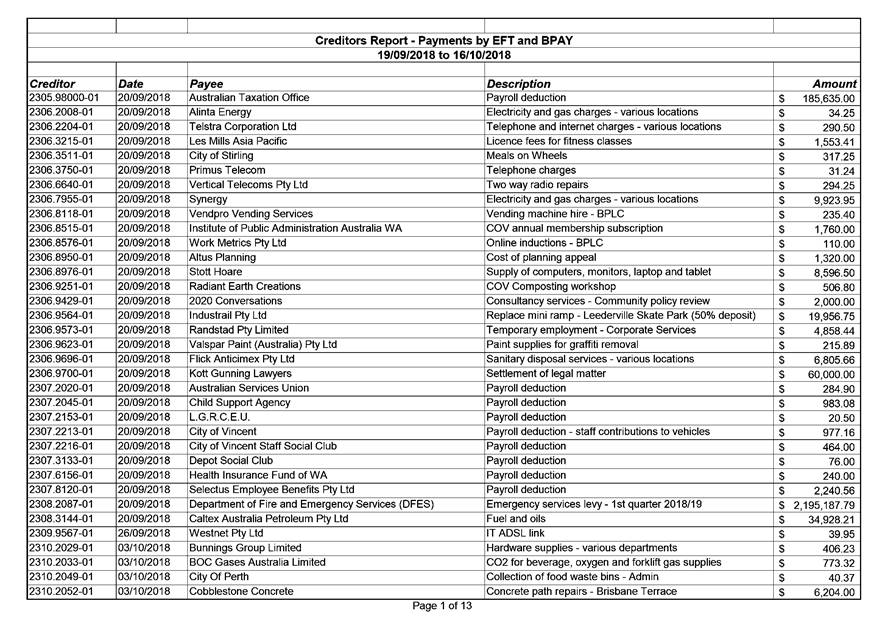
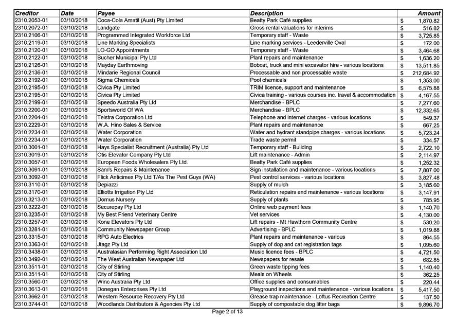
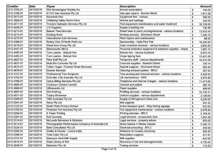
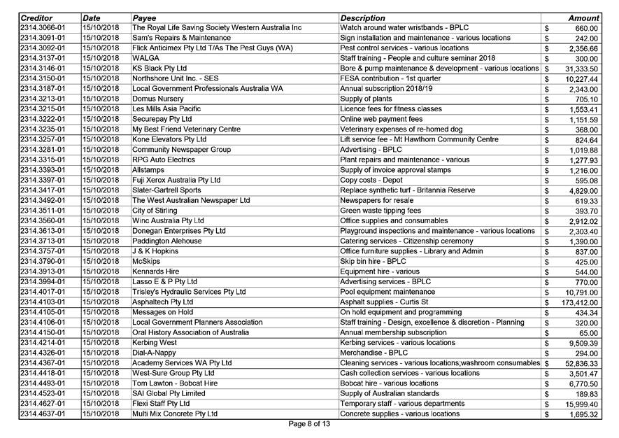
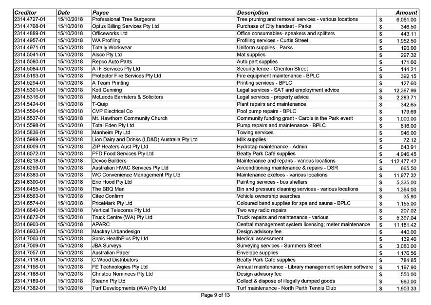
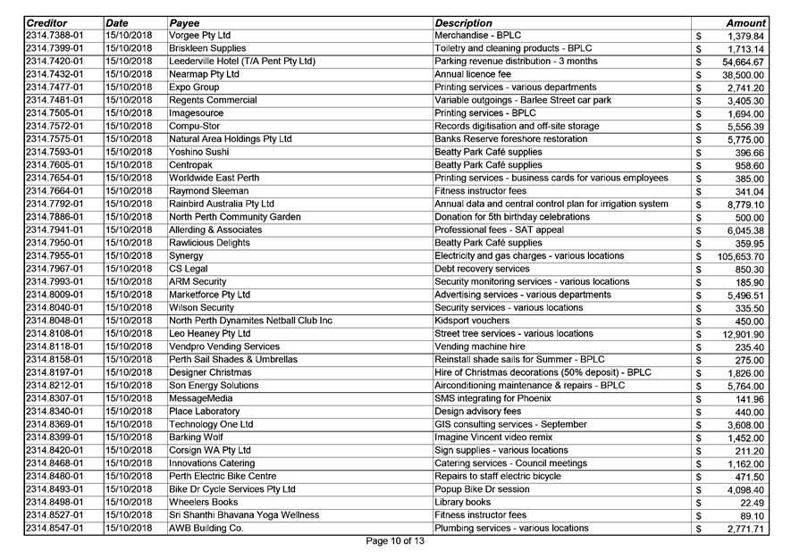
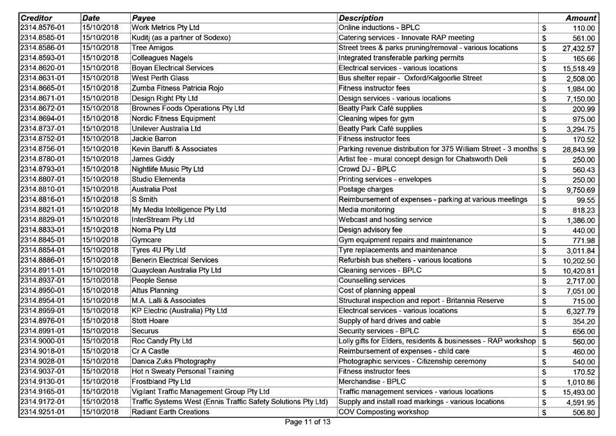
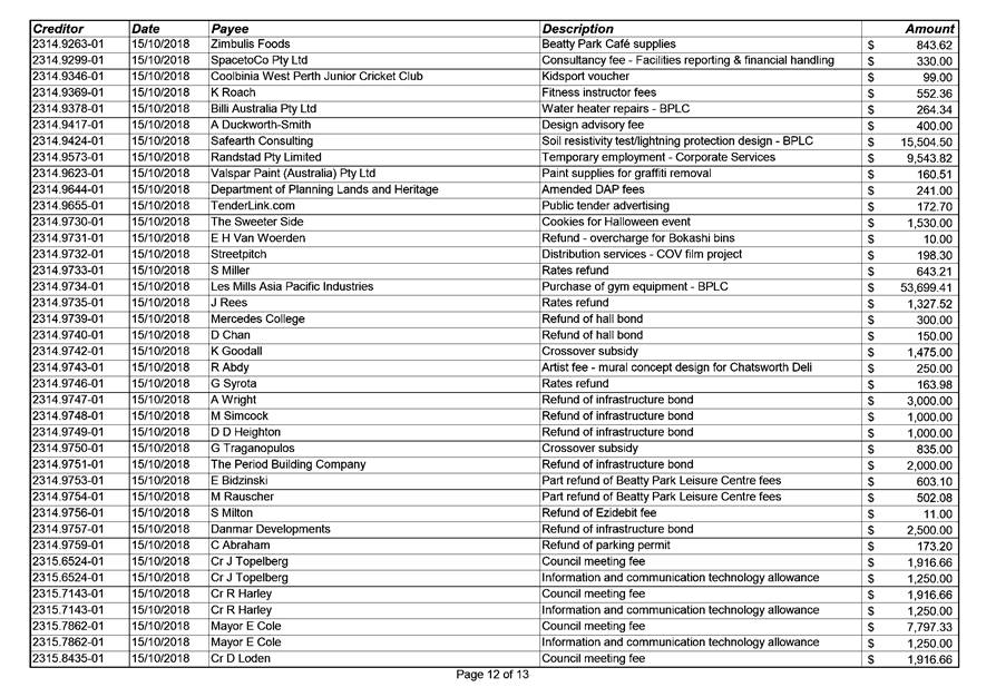
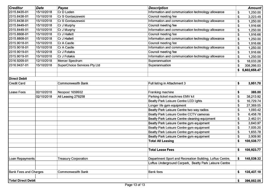
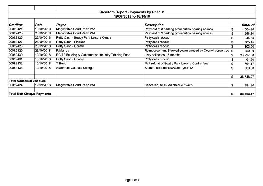
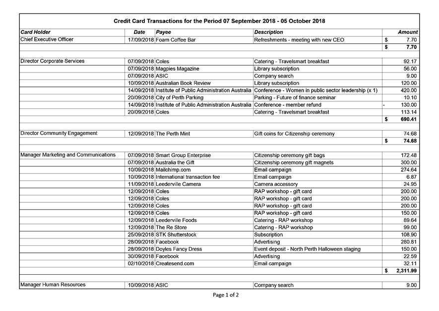
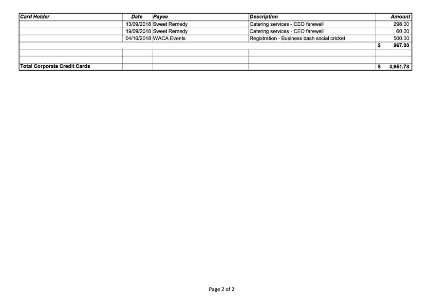
7.2 Authorisation of Expenditure for the Period 19 September 2018 to 16 October 2018
7.4 LATE REPORT: City of Vincent Statutory Review of Wards and Representation
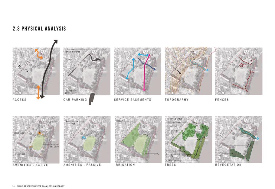
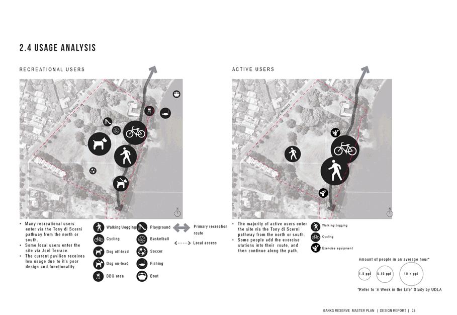
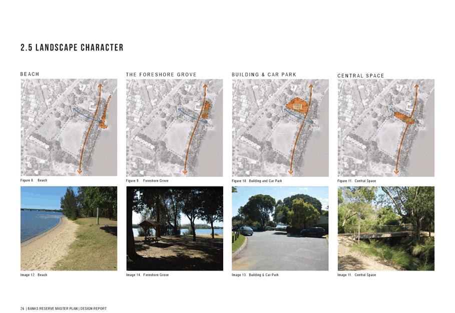
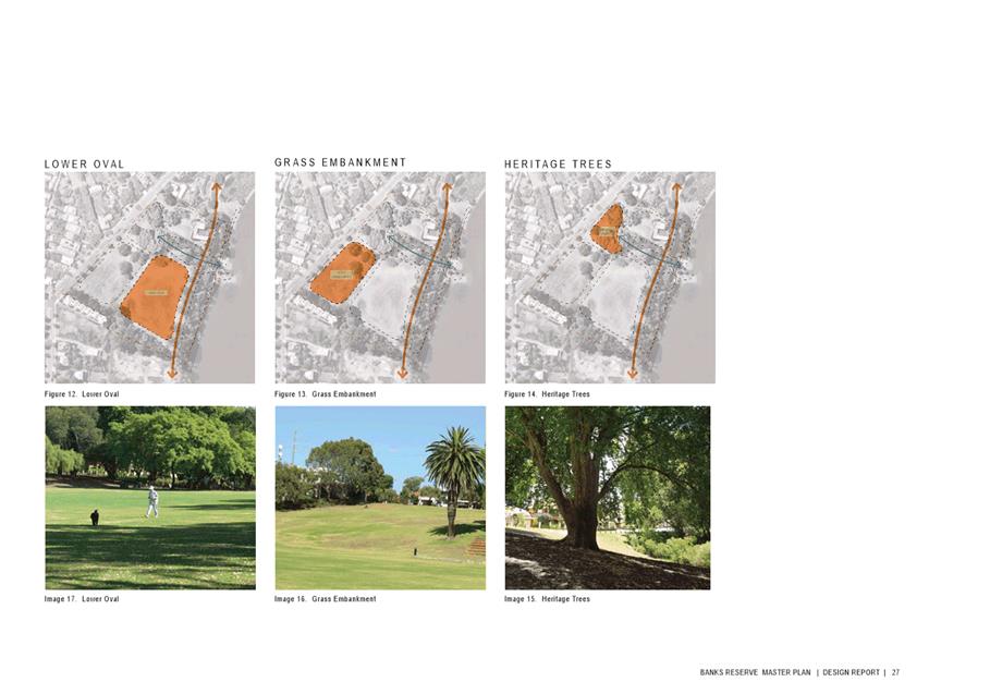
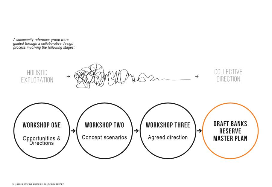
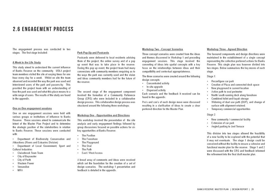
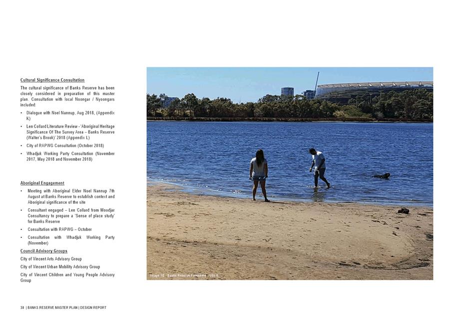
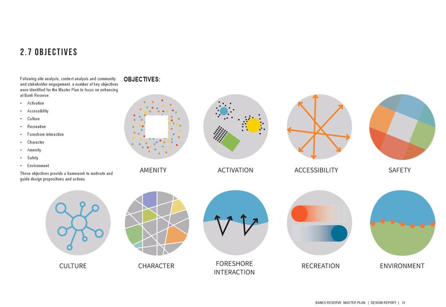
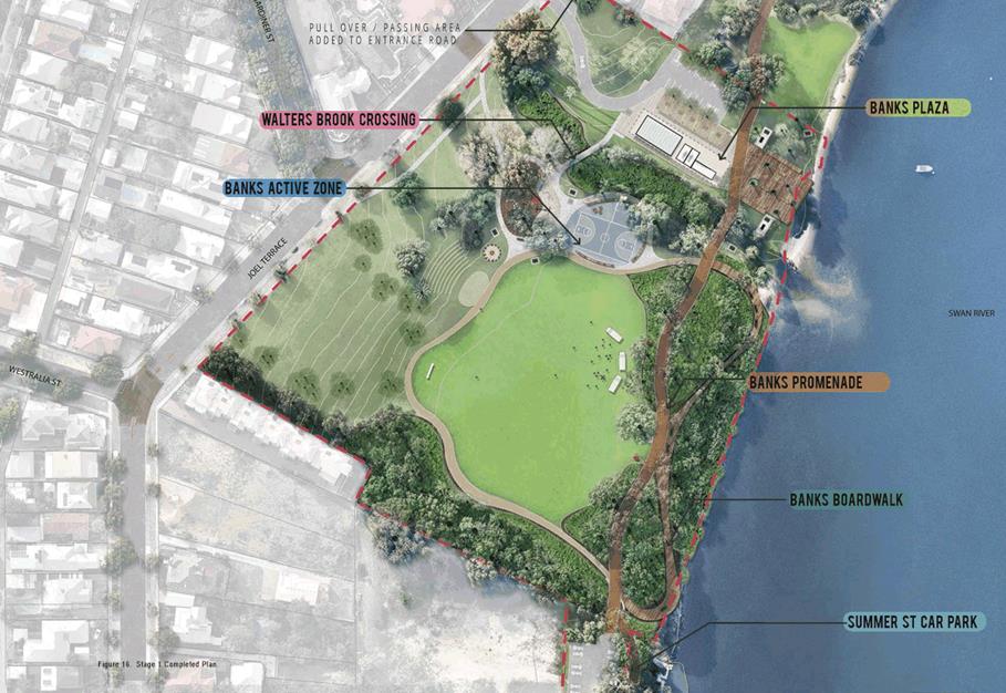
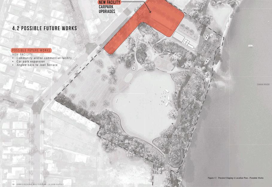
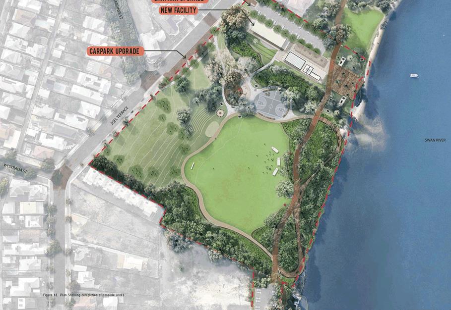
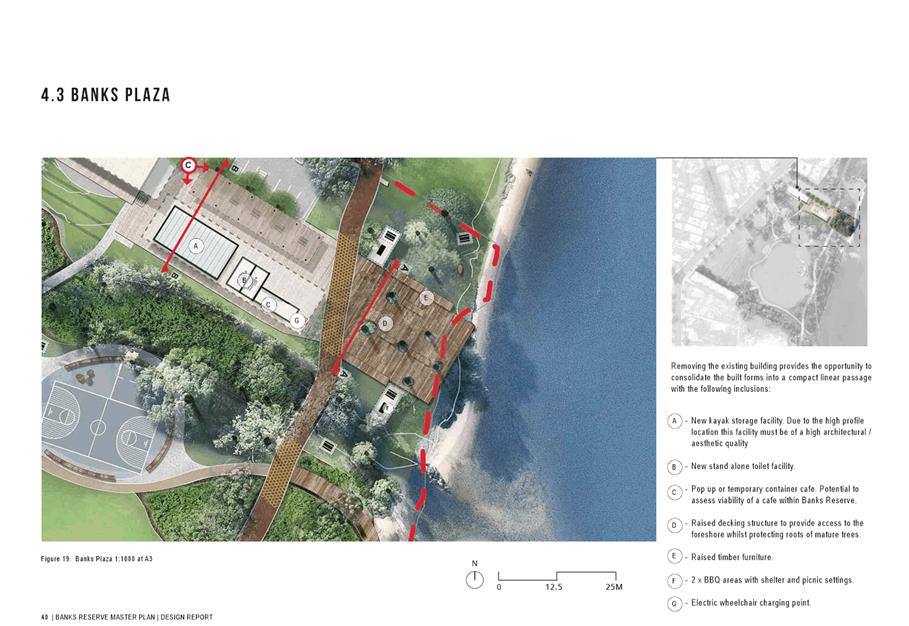
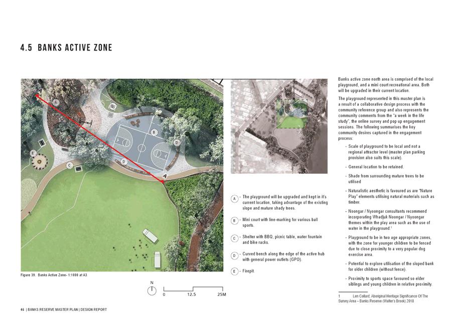
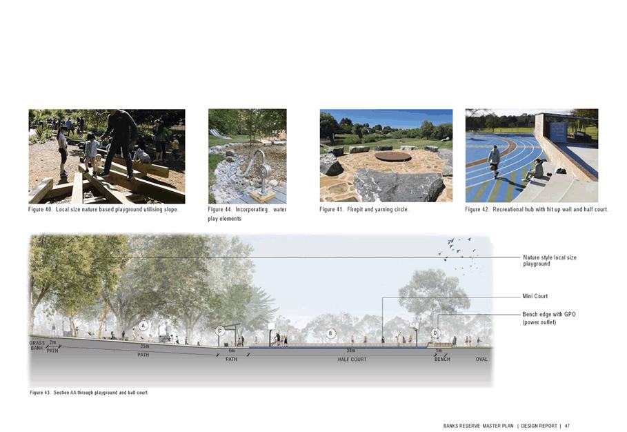
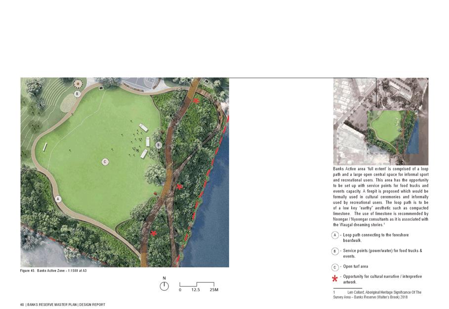
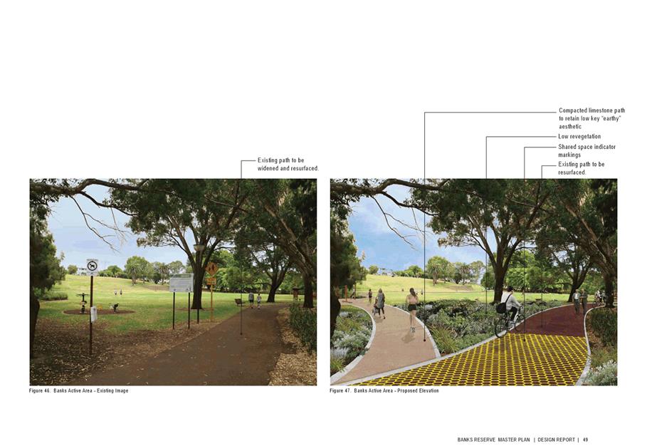
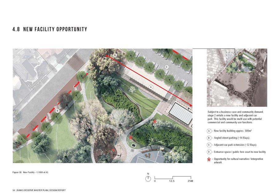
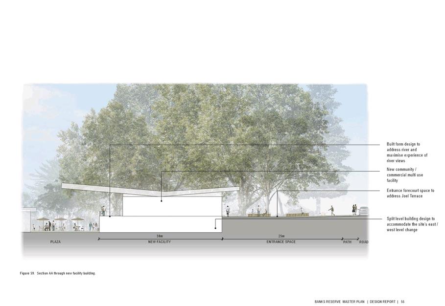
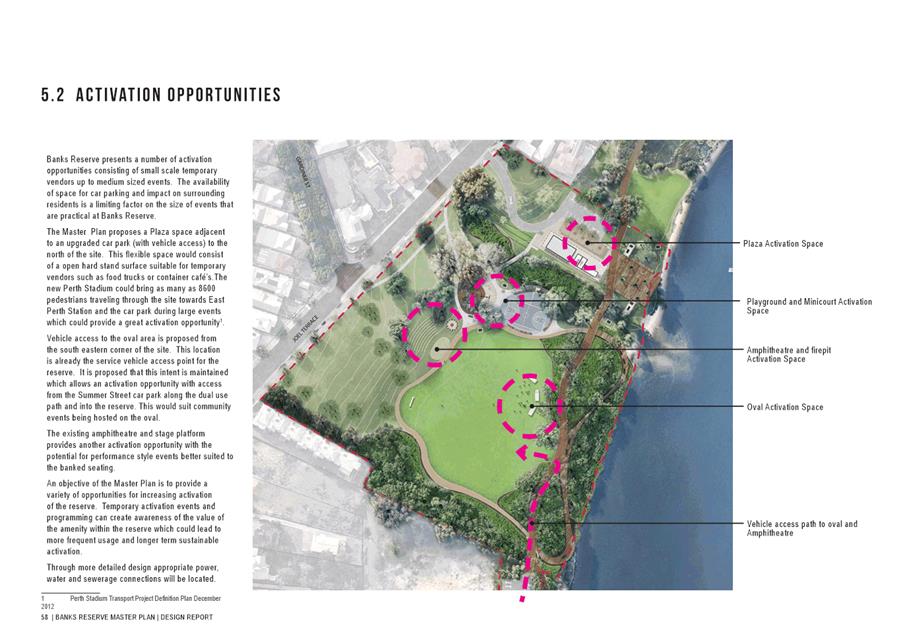
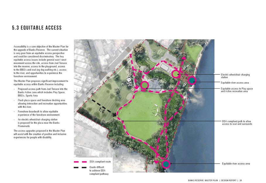
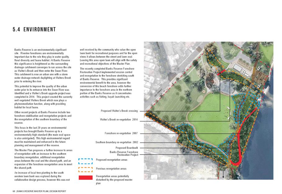
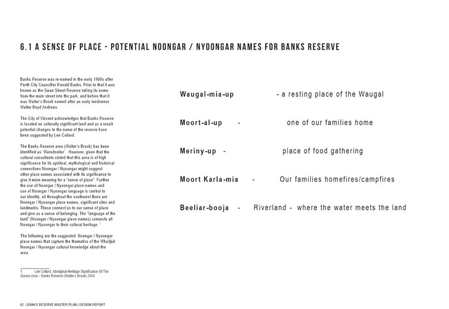
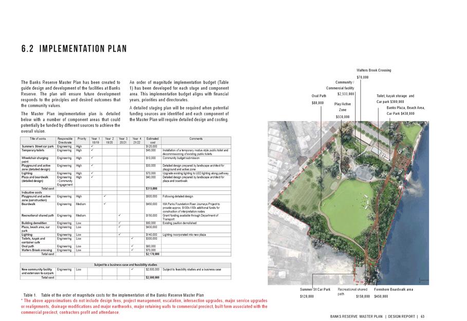
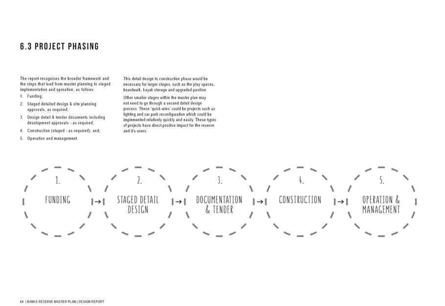
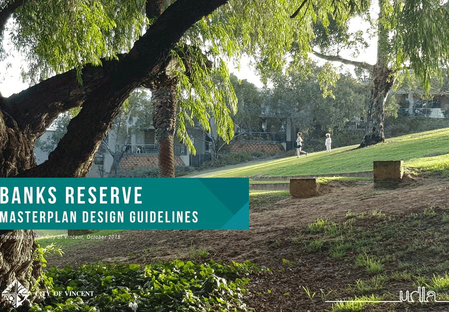
8.1 Draft Banks Reserve Master Plan
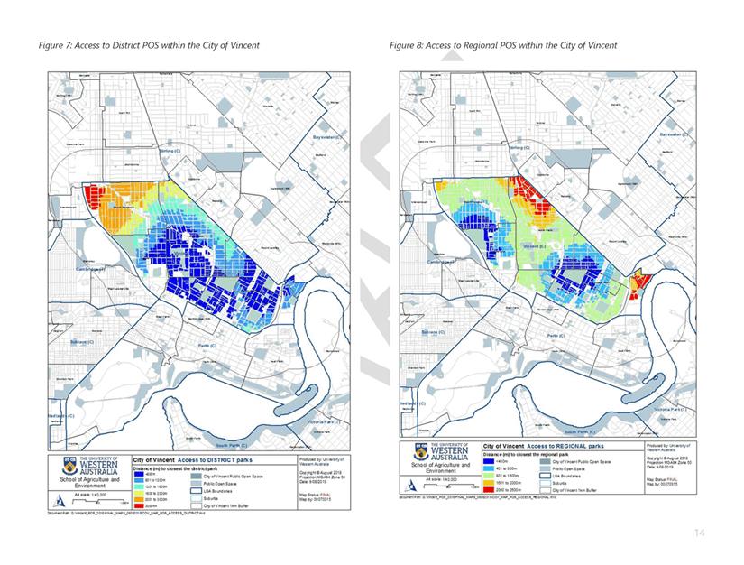
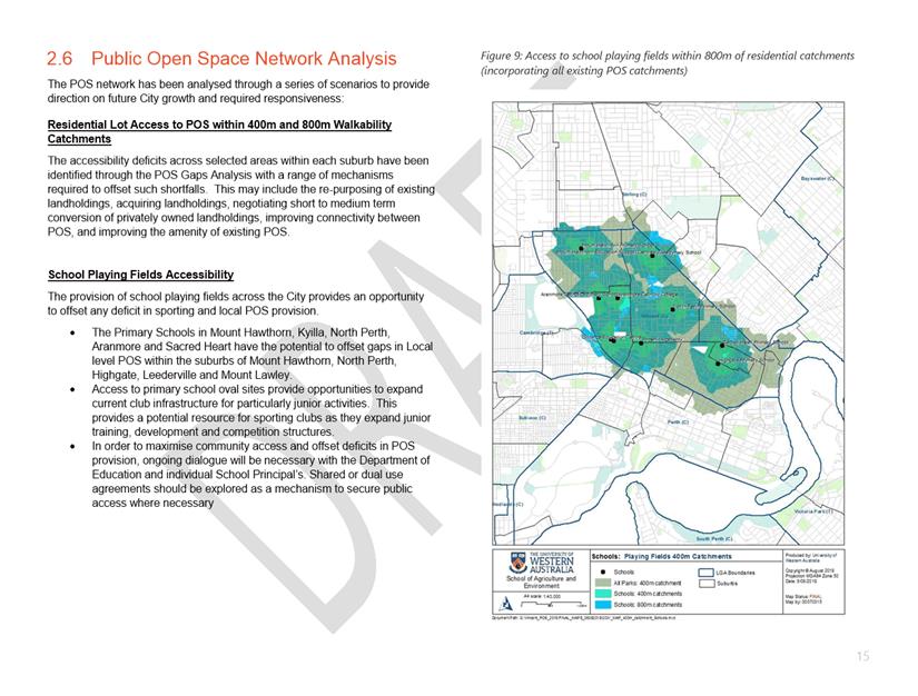
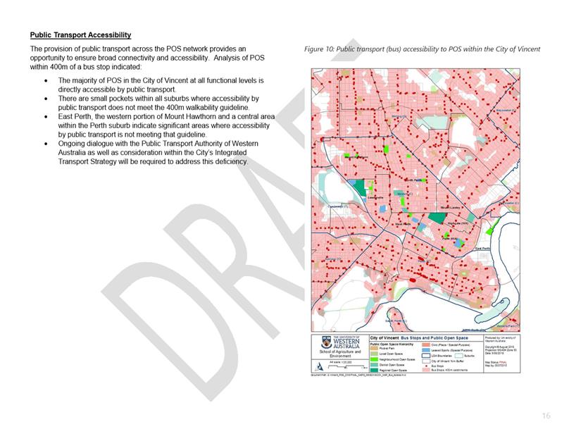
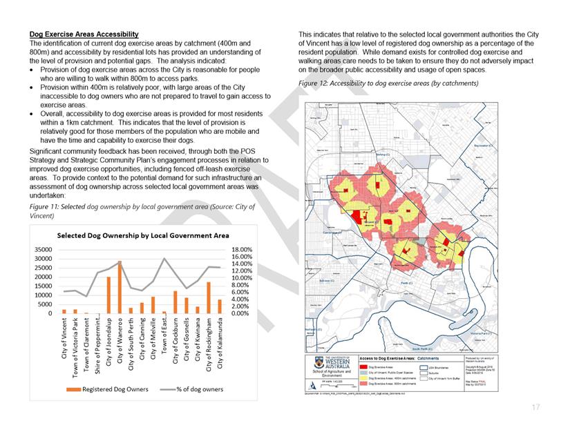
8.2 Draft Public Open Space Strategy
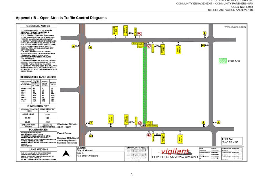
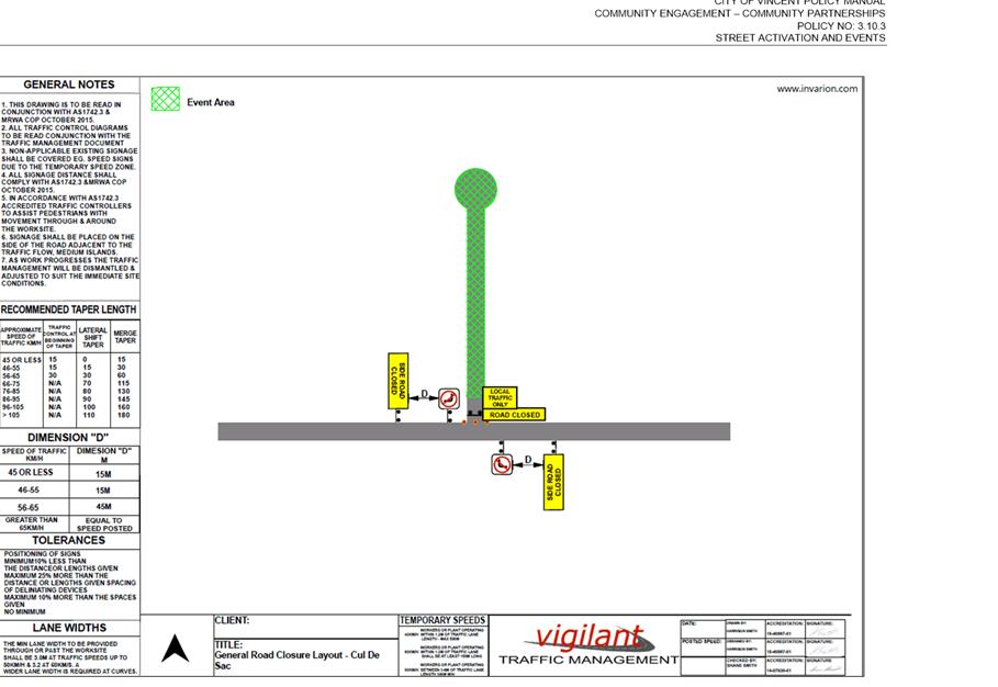
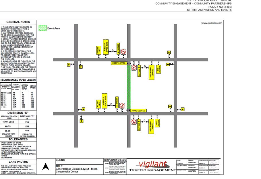
8.3 Adoption of Policy No. 3.10.3 - Street Activation
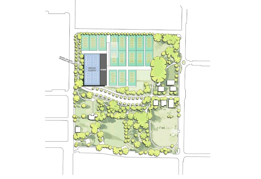
8.4 Tennis West Proposal for Robertson Park, Fitzgerald Street, Perth
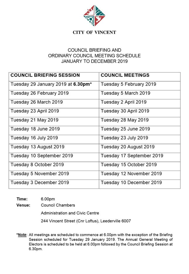
9.1 Council Briefing and Ordinary Meeting of Council Dates for 2019
9.2 Annual Report 2017/2018 [ABSOLUTE MAJORITY DECISION REQUIRED]
10 Motions of Which Previous Notice Has Been Given
11 Representation on Committees and Public Bodies
12 Confidential Items/Matters For Which The Meeting May Be Closed (“Behind Closed Doors")
12.1 LATE REPORT: Leederville Gardens Inc Board Appointments
“The City of Vincent would like to acknowledge the Traditional Owners of the land, the Whadjuk people of the Noongar nation and pay our respects to Elders past, present and emerging”.
2 Apologies / Members on Leave of Absence
Nil
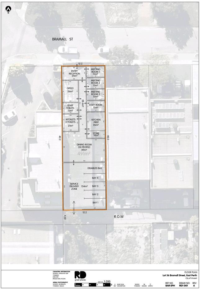
5.1 No. 13 (Lot: 36; D/P: 2001) Bramall Street, East Perth - Change of Use to Unlisted Use (Community Purpose)
TRIM Ref: D18/141112
Author: Mitchell Hoad, Senior Urban Planner
Authoriser: Luke Gibson, A/Director Development Services
Ward: South
Attachments: 1. Attachment
1 - Location and Consultation Map ⇩ ![]()
2. Attachment
2 - Development Application Plans ⇩ ![]()
3. Attachment
3 - Parking Management Plan ⇩ ![]()
4. Attachment
4 - Summary of Submissions ⇩ ![]()
5. Attachment
5 - Applicant's response to Summary of Submissions ⇩ ![]()
6. Attachment
6 - Determination Advice Notes ⇩ ![]()
|
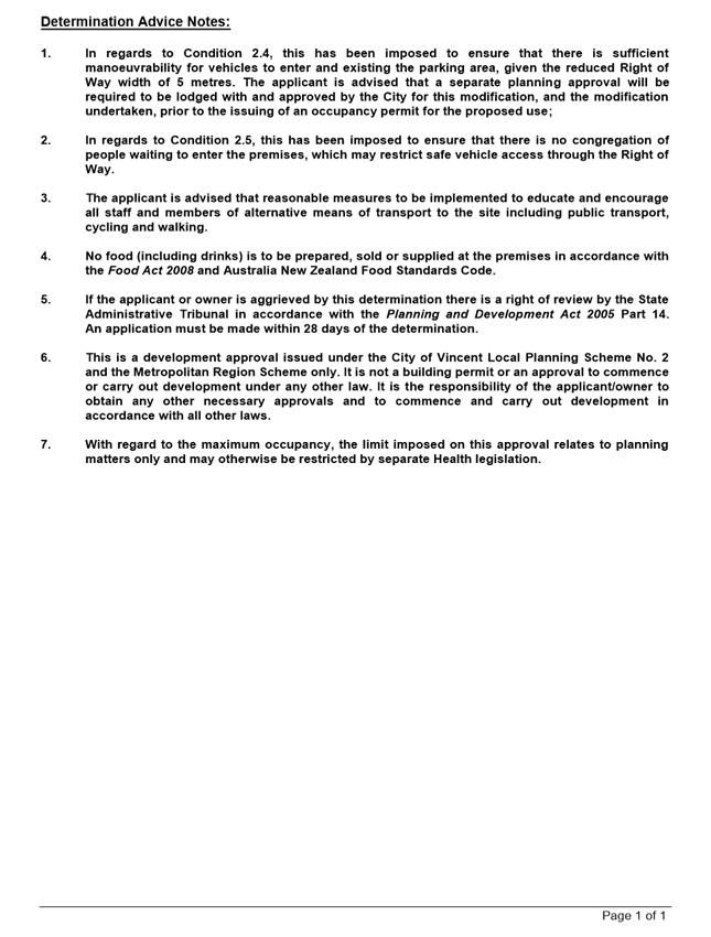
That Council, in accordance with the provisions of the City of Vincent Local Planning Scheme No. 2 and the Metropolitan Region Scheme, APPROVES the application for a Change of Use from Factory to Unlisted Use (Community Purpose) at No. 13 (Lot: 36; D/P: 2001) Bramall Street, East Perth, in accordance with the plans shown in Attachment 2 and the determination advice notes contained within Attachment 6: 1. Use of Premises 1.1 This approval relates to a Change of Use from Factory to Unlisted Use (Community Purpose) as shown on the plans dated 3 September 2018. It does not relate to any other development on the site; 1.2 This approval is valid for two years from the date of approval for the Unlisted Use (Community Purpose); 1.3 A maximum of 60 people are permitted on the site at any one time, being comprised of four full-time staff, six volunteers and 50 visitors; 1.4 The hours of operation for the Unlisted Use (Community Purpose) shall be limited to the following: Private Use (no visitors) Monday to Friday: 8:30am to 5:00pm; Visitors Monday to Friday: 10:00am to 2:00pm; 2. Parking and Access 2.1 A minimum of four off-street parking bays shall be provided; 2.2 All off-street parking is to be available during business hours for staff members. The parking bays are not to be used for storage purposes or the like; 2.3 A minimum of six bicycle facilities (two internal and four external) shall be provided and designed in accordance with AS2890.3 prior to the occupation of the premises; 2.4 Prior to the use of the premises as an Unlisted Use (Community Purpose), the existing roller door to the Right of Way shall be modified to provide a minimum width of 6 metres; 2.5 Access to the premises from the Right of Way shall be restricted to staff and volunteers only. Visitors to the premises shall only enter the premises from Bramall Street; and 2.6 The existing crossover from Bramall Street being removed, and the kerbing and verge reinstated with landscaping to the specification and satisfaction of the City; 3. Management Plan Prior to occupation, a Management Plan is to be submitted to and approved by the City, that addresses the control of anti-social behaviour (to reasonable levels) associated with the proposed use, including how visitors to will enter and leave the premises. The Management Plan is to be approved by the City and thereafter implemented to the City’s satisfaction, and is to consider the following: 3.1 How visitors will be managed, including before, during and after the lunch period, so as to minimise the impact on the surrounding area; 3.2 A complaints management procedure, detailing how complaints and incidents will be managed should they occur; 3.3 Security and safety of staff, volunteers, and visitors within the premises, as well as adjoining businesses and residents; and 3.4 Waste management; 4. Signage All signage is to be in strict accordance with the City’s Policy No. 7.5.2 – Signs and Advertising, unless further development approval is obtained; and 5. General Conditions that have a time limitation for compliance, and the condition is not met in the required time frame, the obligation to comply with the requirements of the condition continues whilst the approved development exists. |
Purpose of Report:
To consider an application for development approval for a Change of Use to an Unlisted Use (Community Purpose) at No. 13 Bramall Street, East Perth (subject site).
PROPOSAL:
The application proposes a Change of Use from the existing Factory to an Unlisted Use (Community Purpose) at the subject site, to facilitate the operations of “The Shopfront”, which is a drop-in service operated by the Catholic Church.
Background:
|
Landowner: |
Fineline Print and Copy Service Pty Ltd |
|
Applicant: |
Roberts Day |
|
Date of Application: |
6 September 2018 |
|
Zoning: |
MRS: Urban LPS2: Zone: Commercial R Code: Not applicable |
|
Built Form Area: |
Activity Corridor |
|
Existing Land Use: |
Factory |
|
Proposed Use Class: |
Unlisted Use (Community Purpose) |
|
Lot Area: |
491m² |
|
Right of Way (ROW): |
Southern side, City owned, 4 metres in width and sealed |
|
Heritage List: |
Not applicable |
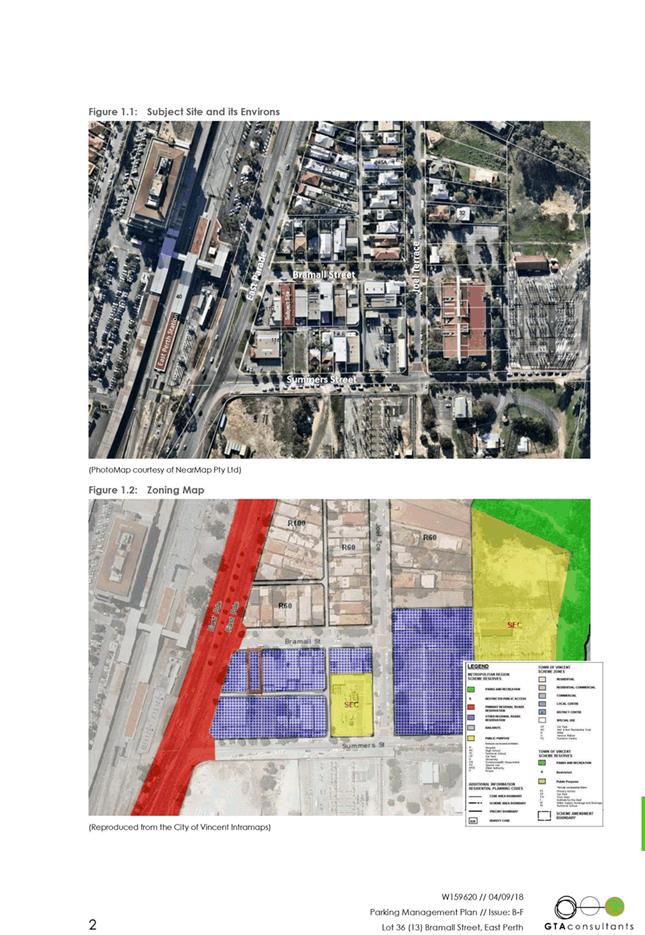
The subject site is zoned Commercial under the City of Vincent Local Planning Scheme No. 2 (LPS2) and is bound by Bramall Street to the north, a ROW to the south, Nos. 110 – 116 East Parade, to the west, and No. 9 Bramall Street to the east. The sites to the east, west and south of the subject site is zoned Commercial under LPS2 and consist of commercial uses. The properties on the northern side of Bramall Street are zoned Residential R60 under LPS2 and consist of predominantly single-storey Single Houses. A location plan is included as Attachment 1.
The subject site currently accommodates of single-storey commercial building, which was previously operating as a factory, and was most recently occupied by Fineline Print and Copy Service. The City was unable to obtain any records of when the factory was originally approved or constructed. Fineline Print and Copy Service has since relocated from the subject site and the building is currently vacant.
Details:
The application proposes to change to use of the subject site from Factory to Unlisted Use (Community Purpose), to facilitate the activities of “The Shopfront”, which is a community service operated by the Catholic Church. The applicant has advised that the “The Shopfront” currently operates from a premises in Maylands and “provides assistance and acts as a referral to visitors who may be experiencing difficulties dealing with problems in their life (i.e. accommodation, budgeting, depression, hunger, and loneliness)”. The applicant has advised that the service is focussed on the elderly and single mothers who may be in the need of assistance.
The proposed use (including parking) is confined within the existing building, which covers the entire site. With the exception of the signage (outlined below), no other external modifications or additions to the existing building are proposed as part of this development application. The application proposes to utilise the existing Bramall Street entrance, as well as the existing roller door at the rear of the site to provide access from the ROW. The details of the application include:
Internal Use and Facilities
· Three counselling rooms;
· A dining space to accommodate up to 50 people at any one time; and
· A reception area, office space for administration activities, a staff room, a storage area for non-perishable items, and toilets for visitors and staff.
Parking and Access
· Four staff parking bays at the rear of the site with access from the ROW. The bays are located within the existing building footprint, which enables this to be securely managed. In addition, six bicycle spaces are proposed to be provided, with two spaces being located inside the building and four spaces being located within the Bramall Street verge;
· The applicant has advised that the roller door will be opened and closed manually by staff to allow volunteers and visitors to access the building from the rear during the lunch period, and after this access will be restricted to allow for vehicles to exit; and
· Laundry services will also utilise this space for deliveries and pick-ups.
Operating Hours and Staff Numbers
· The premises will be staffed by four full time staff members between 8:30am and 5:00pm, Monday to Friday;
· The premises will be open for visitors between 10:00am and 2:00pm, Monday to Friday. During this time, six volunteers will also be in attendance to assist with the lunch period (consisting of light refreshments such as sandwiches, tea and coffee), which operates between 11:00am and 2:00pm. It is estimated that up to 50 visitors will utilise the premises between these operating hours, most likely at an average of 15 visitors per hour; and
· Before 10:00am and after 2:00pm, the building will be closed to visitors, and will only be occupied by the four full time staff members.
Signage
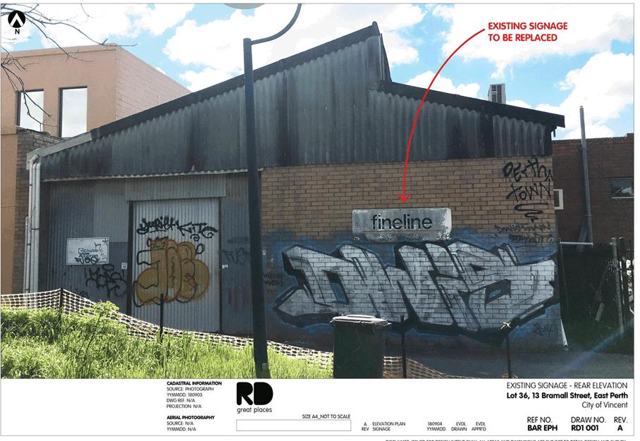
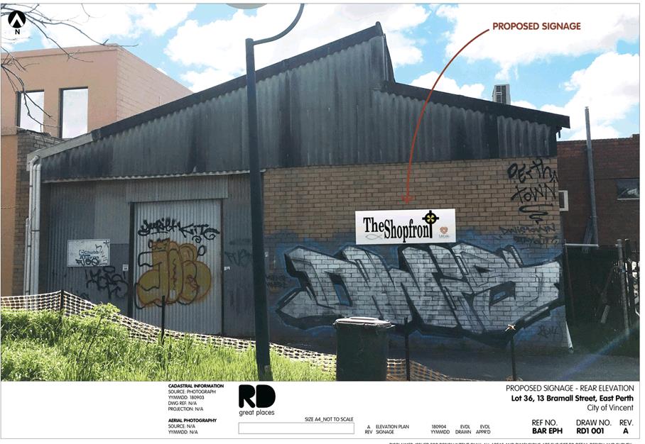
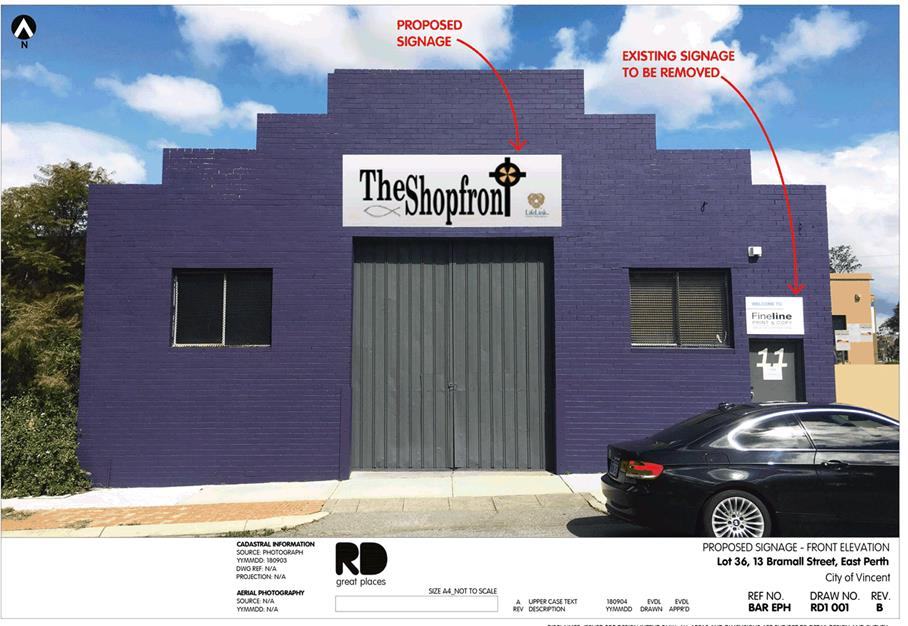
· One wall sign measuring 1 metre high by 3.5 metre wide affixed to the front façade facing Bramall Street, containing the name and logo of “The Shopfront”;
· One wall sign measuring 1 metre high by 3.5 metre wide affixed to the rear façade facing the ROW, containing the name and logo of “The Shopfront”; and
· The removal of all existing signage currently advertising Fineline Print and Copy Services.
The development application plans are included as Attachment 2. In support of the application, the applicant has provided a Parking Management Plan prepared by GTA Consultants, which is included as Attachment 3.
The table below summarises the planning assessment of the proposal against the provisions of the City’s LPS2, the City’s Policy No. 7.7.1 – Non-Residential Development Parking Requirements (Parking Policy), and the City’s Policy No 5.7.2 – Signs and Advertising. In each instance where the proposal requires the discretion of Council, the relevant planning element is discussed in the Detailed Assessment section following from this table.
|
Planning Element |
Use Permissibility/ Deemed-to-Comply |
Requires the Discretion of Council |
|
Land Use |
|
ü |
|
Parking & Access |
|
ü |
|
Signage |
ü |
|
Detailed Assessment
The deemed-to-comply assessment of the element that requires the discretion of Council is as follows:
|
Land Use |
|
|
Deemed-to-Comply Standard |
Proposal |
|
Local Planning Scheme No. 2
“P” use |
Unlisted Use is considered an “A” use in accordance with Clause 18(4)(b) of LPS2. |
|
Car Parking |
|
|
Deemed-to-Comply Standard |
Proposal |
|
Policy No. 7.7.1 – Non-Residential Development Parking Requirements
Unlisted Uses have no prescribed parking requirement under Table 1 of the City’s Policy No. 7.7.1 – Non-Residential Parking Requirement, with parking to be determined by the City based on a site specific Parking Management Plan. |
The application proposes four on-site staff parking bays, and is supported by a Parking Management Plan. |
The above elements of the proposal do not meet the specified deemed-to-comply standards and are discussed in the comments section below.
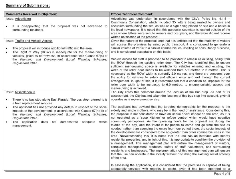
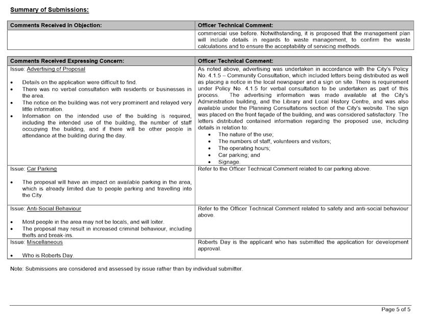
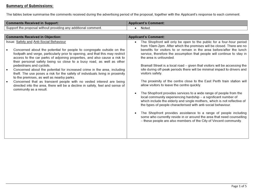
Consultation/Advertising:
Community consultation was undertaken in accordance with the Planning and Development (Local Planning Schemes) Regulations 2015, for a period of 21 days from 1 October 2018 to 22 October 2018. The method of consultation being a sign on site, an advertisement in the local newspaper, and 35 letters mailed to all owners and occupiers surrounding the site (as shown in Attachment 1), in accordance with the City’s Policy No. 4.1.5 – Community Consultation.
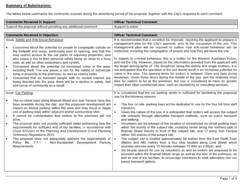
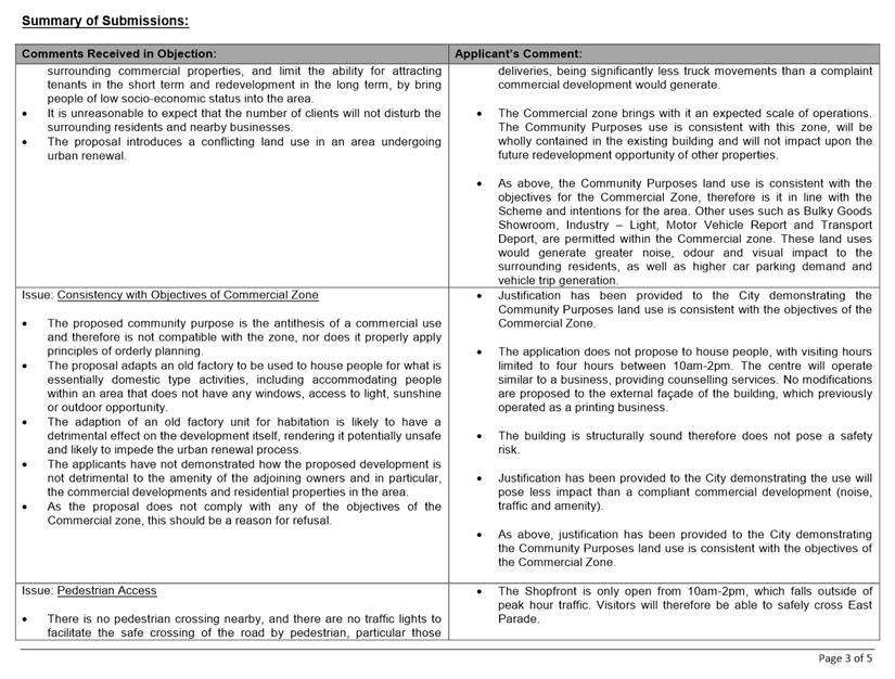
A total of 13 submissions were received, one supporting the proposal, 11 objecting to the proposal and one expressing concerns. The main concerns raised by the submissions are as follows:
· Consistency with the objectives of the Commercial zone of LPS2;
· The intended patron numbers relative to the size of the subject building
· Inadequate provision of car parking, including the availability of on-street parking;
· Pedestrian access to the site; and
· Anti-social behaviour, including the potential for people to congregate outside of the building.
Administration’s and the applicant’s responses to the submissions received are provided as Attachment 4 and Attachment 5 respectively.
Design Review Panel (DRP):
Referred to DRP: No
Legal/Policy:
· Planning and Development Act 2005;
· Planning and Development (Local Planning Schemes) Regulations 2015;
· City of Vincent Local Planning Scheme No. 2;
· Policy No. 4.1.5 – Community Consultation; and
· Policy No. 7.5.2 – Signs and Advertising.
In accordance with Schedule 2 Clause 76(2) of the Planning and Development (Local Planning Schemes) Regulations 2015 and Part 14 of the Planning and Development Act 2005, the applicant will have the right to apply to the State Administrative Tribunal for a review of Council’s determination.
Delegation to Determine Applications:
In accordance with Clause 6.2(9) of the City’s Delegated Authority Register 2018-2019, the application is required to be determined by Council as the development proposes a use which is not listed in Table 1 of the City’s Parking Policy.
Risk Management Implications:
It is Administration’s view that there are minimal risks to Council and the City’s business function when Council exercises its discretionary power to determine a planning application.
Strategic Implications:
The City’s Strategic Plan 2013-2023 states:
“Natural and Built Environment
1.1 Improve and maintain the natural and built environment and infrastructure.”
SUSTAINABILITY IMPLICATIONS:
Nil.
Financial/Budget Implications:
Nil.
Comments:
Land Use
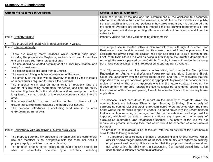
The subject site is zoned Commercial under LPS2, with the area located south of Bramall Street also zoned Commercial, and the area north of Bramall Street zoned Residential R60. The immediate vicinity surrounding the subject site consists of a mix of commercial uses south of Bramall Street, and existing residential development north of Bramall Street.
During the consultation period, concerns were received in regards to the appropriateness of the uses, including consistency with the objectives of the Commercial zone. In considering the appropriateness of the use, Council shall have regard to the objectives of the Commercial zone under LPS2, as follows:
· To facilitate a wide range of compatible commercial uses that support sustainable economic development within the City.
· To ensure development design incorporates sustainability principles, with particular regard to waste management and recycling and including but not limited to solar passive design, energy efficiency and water conservation.
· To maintain compatibility with the general streetscape, for all new buildings in terms of scale, height, style, materials, street alignment and design of facades.
· To ensure that development is not detrimental to the amenity of adjoining owners or residential properties in the locality.
In considering the above objectives, the following is relevant:
· The application involves a community use, not a commercial use. Whilst the relevant objective does not necessarily prohibit community uses, Council needs to consider the compatibility of any such use with the intended commercial context. In this regard, it is not uncommon for community uses to be located within commercially zoned areas.
· The proposed development does not compromise the ability for the surrounding Commercial zoned land to be used for more intensive commercial activities.
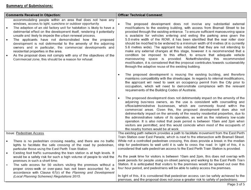
· The proposed development does not involve any substantial external modifications to the existing building.
· It could reasonably be considered that the proposal contributes towards sustainability through the adaptive reuse of an existing building.
· The proposed development is reusing the existing building, and therefore maintains the existing streetscape, although it does involve the removal of the existing Bramall Street crossover and installation of bicycle parking facilities. This change is considered likely to have a positive impact on the streetscape.
· In considering whether or not the development is likely to be detrimental to the amenity of adjoining owners or residential properties in the locality, Council must consider the practical impacts of the proposal, including car parking, access, operating hours and management of anti-social behaviour. These matters are discussed later in the report.
For the reasons outlined above, providing that the proposed land use is able to limit the impacts on the surrounding area, it can be considered to be consistent (at least not inconsistent) with the objectives of the Commercial zone under LPS2.
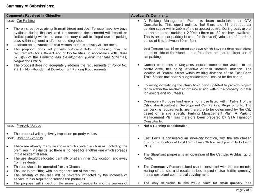
Parking
In accordance with the Parking Policy, where a use is not listed, the requirement is to be determined by the City by a site specific management plan. In addition, concerns were received during the consultation period regarding car parking for the use, specifically the availability of on-street parking. The applicant has provided a Parking Management Plan (which is included as Attachment 3), and proposes a total of four bays to be provided on site, dedicated to staff. Volunteers and visitors are proposed to access the subject site through public transport and alternative transport methods, or by utilising on-street parking within the vicinity of the subject side.
During the consultation period, concerns were received over the provision of adequate car parking to service the premises. In considering the matter, the following is relevant:
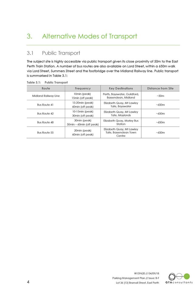
Public Transport and Alternative Methods of Transport
· The applicant has advised that given the circumstances of visitors utilising “The Shopfront” premises in Maylands, all visitors travel either by public transport or by walking. The applicant has also advised that “The Shopfront” can provide vouchers to visitors to cover some of the costs associated with public transport;
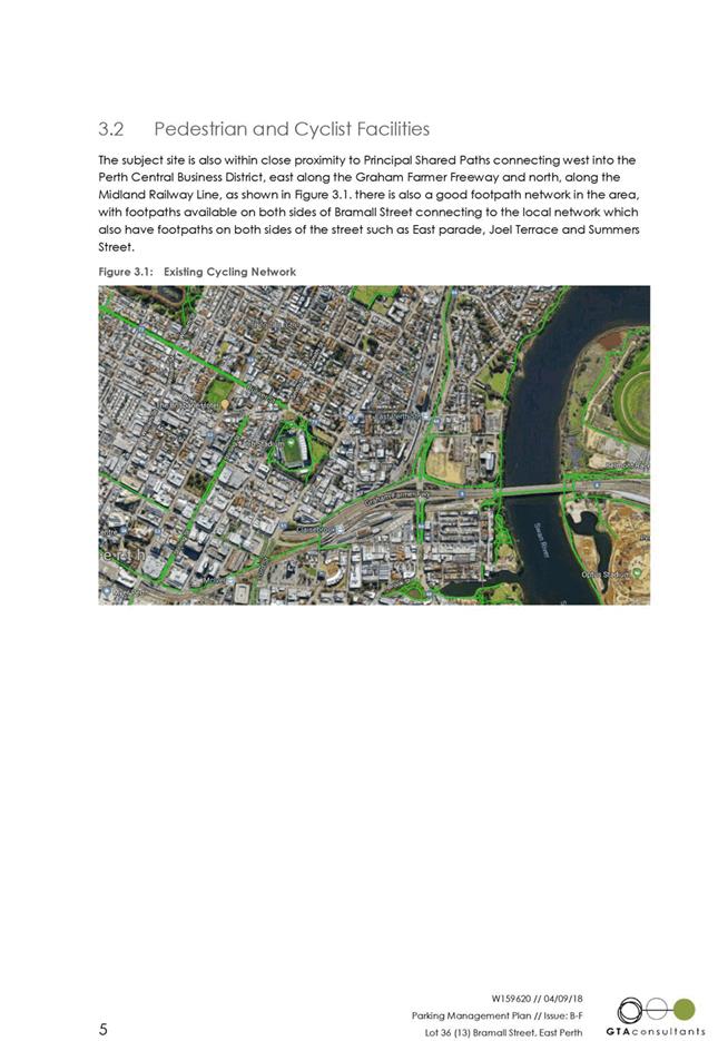
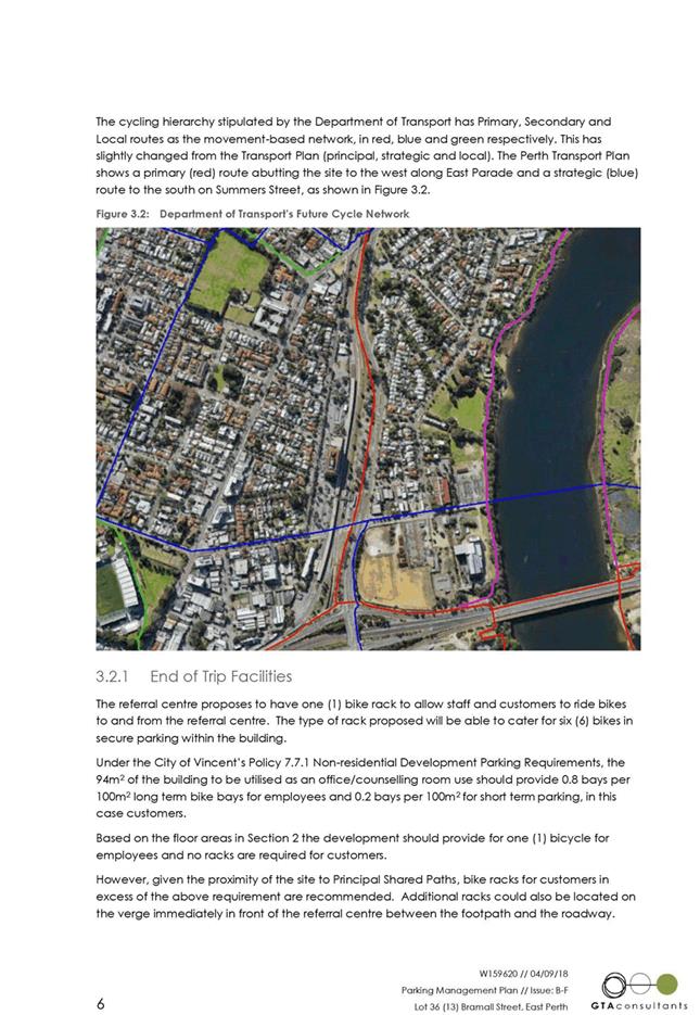
· There is an existing footpath located along Bramall Lane which connects to an existing footpath on the western side of East Parade, and an existing shared path on the eastern side of East Parade. The application also proposes to provide six bicycle spaces, with four of these to be located within the Bramall Street verge in front of the premises, for convenient access for visitors. The other two spaces are proposed to be provided within the internal parking area to provide a secure area for volunteer’s bicycles to be stored. End of trip facilities, including lockers and showers, are also proposed to be provided within the staff room and toilet facilities respectively;
· The subject site is located approximately 50 metres from the East Perth Train Station; and
· The subject site is located approximately 650 metres from a bus stop, which has services operating every 10 minutes to 30 minutes in peak periods, and 30 minutes to 60 minutes in off-peak periods.
· The proposal has identified the provision of end of trip facilities for pedestrians and cyclists, including separate staff and visitor toilets, shower facilities, and the installation of bicycle racks within the Bramall Street verge and the rear staff parking area. In light of this, it is considered that the proposal provides adequate end of trip facilities for pedestrians and cyclists.
Car Parking
· The application proposes to provide four on-site parking bays dedicated to full time staff, which are accessed from the existing ROW and can be secured;
· There is currently on-street car parking available directly adjacent to the subject site along Bramall Street. The parking on the southern side of Bramall Street is restricted to 2 hour parking. The parking along the northern side is unrestricted, although there are some portions of which are no stopping areas, and thus cannot be used for parking; and
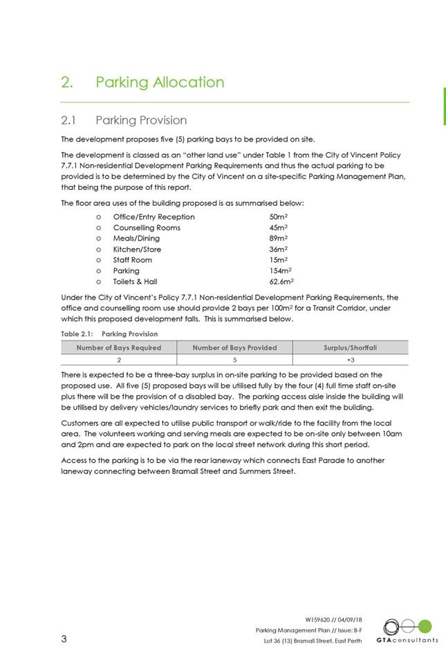
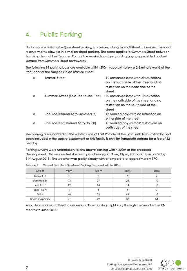
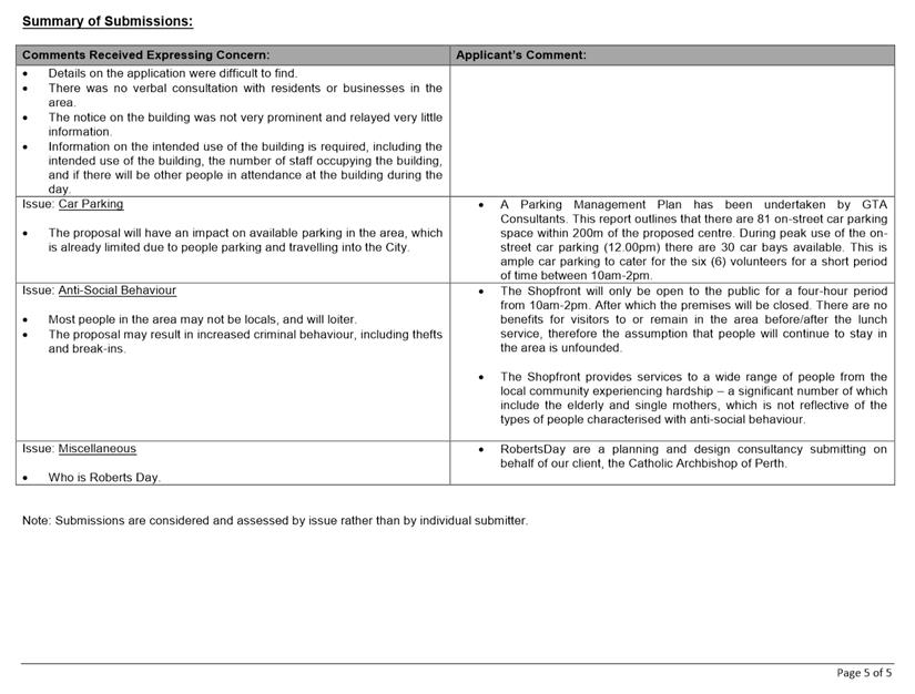
· The Parking Management Plan (included as Attachment 3) details the existing parking conditions and a survey of car parking bays available within 200m of the subject site. This identifies that there is 81 public car parking bays available within 200m of the subject site. Of these 81 bays:
o 30 are restricted to 1 hour parking;
o 27 are restricted to 2 hour parking; and
o 24 do not have time restrictions.
The parking survey, completed on Friday 31 August 2018, identified that over the course of the day (between 9am and 5pm) the peak period was between 12 midday and 2:00pm. During this period, it was identified that there was between 29 and 32 bays available. It was also identified that during this period, 14 of the on-street bays along Bramall Street were available, although it did not differentiate the availability the 2 hour parking available on the southern side of Bramall Street from the unrestricted parking available along the northern side.
The main concern regarding the parking, is to accommodate the six volunteers, given they will be on the site for four hours (between 10am and 2pm), and there are one and two hour parking restrictions on some of the on-street parking in the vicinity of the subject site. The applicant has advised that as part of the induction process, volunteers will be advised to park in the on-street parking available on Joel Street (between Bramall Street and Summers Street) in the first instance, which abuts land owned by Western Power. This section is approximately 100 metres from the subject site, and has 17 unrestricted bays located on either side of the road. The parking survey identified that during the peak period, 14 of these bays were occupied, which would leave three bays available for volunteers to utilise.
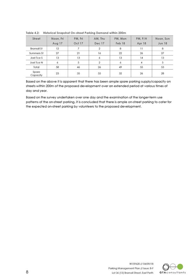
There is also space to accommodate seven vehicles parked along the northern side of Bramall Street, which does not have any parking restrictions. As noted above, the parking survey did not differentiate between the availability of parking on the northern and southern sides of Bramall Street, however a review of Nearmaps indicated that following demand for on-street parking on weekdays:
· Monday 12 February 2018 – two cars parked;
· Thursday 14 December 2017 – no cars parked;
· Friday 20 October 2017 – one car parked;
· Friday 18 August 2017 – no cars parked;
· Tuesday 28 February 2017 – three cars parked;
· Monday 16 January 2017 – three cars parked;
· Monday 28 November 2016 – one car parked; and
· Monday 10 October 2016 – no cars parked.
Whilst it is noted that the above does not cover the entire day, it does indicate that there is generally the ability for between four and seven vehicles to be accommodated along the northern side of Bramall Street. This will provide further opportunities for volunteers to park, should they choose to drive.
The applicant has also advised that as part of the induction process, volunteers will also be made aware of alternative public transport options, such as the East Perth Train Station which is within walking distance to the subject site. There is also six bicycle spaces to be provided. Although some these are likely to be used by visitors, it is noted that there are no restrictions on who could use these, which would provide additional alternative methods for volunteers.
In light of the above information, it is considered that there is sufficient on-site car parking provided to accommodate for staff parking, and there is sufficient public parking available within the immediate locality, along with adequate public transport and alternative transport methods available for volunteers and visitors.
Vehicle access for staff is proposed to be provided to remain as existing, being from the ROW through the existing roller door. From a technical perspective, the City has identified that to ensure sufficient manoeuvring space is available for vehicles entering and existing, the width of the roller door needs to be widened from 5.6 metres to 6 metres. This is necessary as the ROW width is currently 5.0 metres, and there are concerns over the ability for vehicles to safely and efficient enter and exit through the current arrangement. In light of this, it is recommended that a condition be imposed for the roller door width to be increased to 6.0 metres, to ensure suitable access and manoeuvring is achieved.
Pedestrian Access
The parking management plan provided proposes visitors to the premises access the premises through public transport, and walking. The existing path network in the locality provides for a path to facilitate movement from the East Perth Train Station over East Parade, which is next to the intersection with Bramall Street. While not a controlled pedestrian crossing, this does provide a break in the median strip for pedestrians to wait until it is safe to cross the road. Further, the peak time for visitors is between 10am and 2pm, this does not overlap with peak periods for people using on-street parking and walking to the East Perth Train Station. It is anticipated that visitors to the premises would be spread out over this four hour period, and pedestrians will be able to safely access the premises. In light of this, it is considered that pedestrian access can be safely achieved to the premises, and the proposal does not pose a greater risk to safety of pedestrians.
Patron Numbers and Operating Hours
The potential impact of the proposed use on the surrounding area will be, in part, a function of the operating hours. In this regard, the peak period of activity is between 10am and 2pm which would coincide when at least some of the nearby residential occupants would be at work.
With respect to patron numbers, the applicant has advised that a maximum of 60 people would be in the premises during the peak period between 10am and 2pm, consisting of four staff, six volunteers and 50 visitors. However, it is likely that peak attendance would be less, as it is anticipated that visitors will come and go during these hours, and not remain in the premises for the entire four hour period. In terms of the applicable Building Code of Australia requirements, the applicant would need to install a unisex disabled toilet, however, there is sufficient room for this to be accommodated. The provision of that toilet would need to occur prior to an Occupancy Permit being issued by the City.
Anti-Social Behaviour
During the consultation period, concerns were received over the potential for anti-social behaviour, including people loitering outside of the building, particularly prior to opening, as well as criminal behaviour such as theft. In response to this, the applicant provided the following:
· “The Shopfront” provides services to a wide range of people from the local community experiencing hardship, a significant number of which include the elderly and single mothers;
· “The Shopfront” premises currently operating in Maylands does not experience these issues; and
· Volunteers will make visitors aware of end of lunch service, and due to the close proximity to the East Perth Train Station, it is anticipated that visitors will leave the premises quickly. Should there be any incidents, the full time staff will be able to assist.
The application currently proposes for entry to the premises for visitors accessing the lunch service to be provided from the ROW. Should visitors queue outside prior to the premises opening to the public, this may cause safety issues for both visitors and vehicles, given this ROW provides vehicle access to adjoining properties. In light of this, a condition is recommended to restrict visitor access to be from the Bramall Street frontage, so as to address these concerns.
In addition, to address the concerns relating to loitering, anti-social behaviour and the interface with nearby residential properties, it is recommended that if the application is approved, that a condition be imposed to require a management plan to address the following:
· How visitors will be managed, including before, during and after the lunch period, so as to minimise the impact on the surrounding area;
· A complaints management procedure, detailing how complaints and incidents will be managed should they occur;
· Security and safety of staff, volunteers, and visitors within the premises, as well as adjoining businesses and residents; and
· Waste management.
The imposition of the recommended conditions is considered to ensure that the use operates without having a detrimental impact of the nearby area. If the conditions of approval are not adhered to, it would be open to the City to undertake formal compliance action.
Time Limited Approval
Given the unique nature of the use, and its proximity to residential properties, as well as the surrounding locality being an area in transition, it is considered that the imposition of a time limited approval is appropriate. Allowing the premises to operate for an initial two year period will allow a mechanism for a review of whether the use is appropriate within the context, particularly in regards to whether the supply of public car parking within the area is adequate to accommodate volunteers and visitors, as well as whether the management plan is working effectively. If a subsequent application is lodged in future, these aspects can be reassessed, as well as considering whether the use remains consistent with the intent of the planning framework at that point in time and any complaints or incidents that may have occurred during this time. Should the use be considered to still be acceptable, it could be approved with or without a further time limit, depending on how the use has operated within the initial approval period. Should this reassessment identify that the use is no longer appropriate, it would be open to Council to refuse any such application.
It should be noted that this approach is consistent with that taken for a comparable application for 33 (Lot 421) Church Street, Perth, where Council, on 18 December 2012 resolved to approve an Unlisted Use (Community Service) for a period of five years. The time limitation was imposed to enable Council to assess of the impact of the land use on the amenity of the locality, before deciding to allow or not allow the use to continue. On 16 October 2018, Council considered an application for an additional five years and resolved to grant an unrestricted approval on the basis that the premises was operating satisfactorily.
Conclusion
On 6 September 2018, the City received a development application for an Unlisted Use (Community Purpose) at No. 13 Bramall Street, East Perth. Council is required to exercise its discretion with respect to the proposed land use and car parking requirements for the site. The proposal will provide for a community service use which is consistent with the objectives of the Commercial zone as set out in LPS2. The Parking Management Plan submitted for the site is considered to demonstrate that there is sufficient car parking and transport methods to support the proposed use. In light of the above, the proposed Unlisted Use (Community Purpose) is supported, subject to conditions.
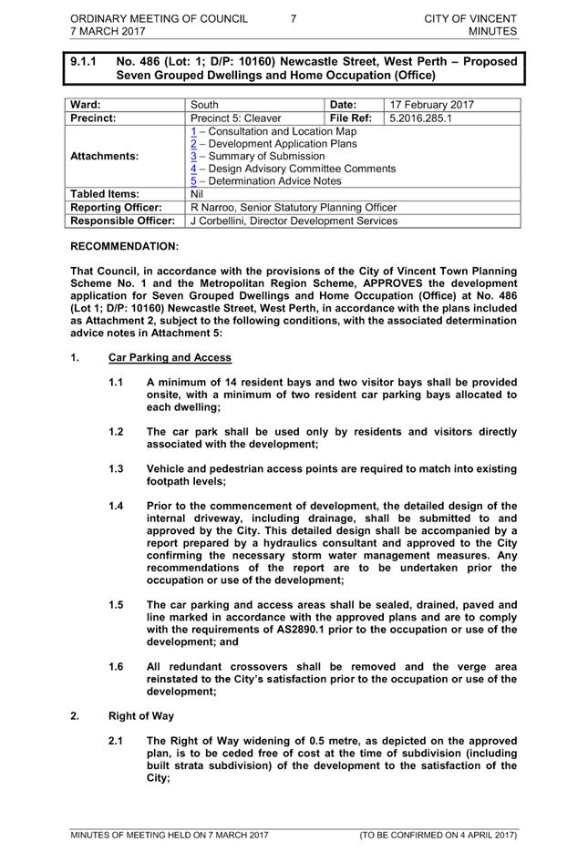
5.2 No. 486 (Lot: 1; D/P: 10160) Newcastle Street, Leederville - Amendment to Approval for Seven Grouped Dwellings and Home Occupation (Office) - Extension of Time
TRIM Ref: D18/136717
Author: Mitchell Hoad, Senior Urban Planner
Authoriser: Luke Gibson, A/Director Development Services
Ward: South
Attachments: 1. Attachment
1 - Location Plan ⇩ ![]()
2. Attachment
2 - Subdivision Approval ⇩ ![]()
3. Attachment
3 - Extract of Ordinary Meeting of Council Minutes 7 March 2017 ⇩ ![]()
|
That Council, in accordance with the provisions of the City of Vincent Local Planning Scheme No. 2 and the Metropolitan Region Scheme, APPROVES the application to amend the development approval for Seven Grouped Dwellings and Home Occupation (Office) at No. 486 (Lot: 1; D/P: 10160) Newcastle Street, Leederville, granted on 7 March 2017 (reference 5.2016.285.1), subject to the following conditions: 1. Unless otherwise noted. all conditions, requirements and advice notes detailed on the development approval 5.2016.285.1 included in Attachment 3 continue to apply to this approval; 2. The modification of Condition 12 so as to reads as follows: “12. Home Business 12.1 The Home Business shall at all times operate in accordance with the definition of a Home Business as prescribed by the City’s Local Planning Scheme No. 2;”; and 3. The addition of a new Condition 15 as follows: “15. This decision constitutes development approval only and is valid until 7 March 2021. If the subject development is not substantially commenced within this period, the approval shall lapse and be of no further effect”. |
Purpose of Report:
To consider an application for development approval for an extension of time to substantially commence development of the previously approved Seven Grouped Dwellings and Home Occupation (Office) at No. 486 Newcastle Street, Leederville (subject site).
PROPOSAL:
The application seeks approval for an extension of time (two years) to substantially commence the previously approved development.
Background:
|
Landowner: |
Eleganza Developments Pty Ltd |
|
Applicant: |
Eleganza Developments Pty Ltd |
|
Date of Application: |
29 August 2018 |
|
Zoning: |
MRS: Urban LPS2: Zone: Mixed Use R Code: R160 |
|
Built Form Area: |
Activity Corridor |
|
Existing Land Use: |
Single House |
|
Proposed Use Class: |
Grouped Dwelling – ‘P’ use Home Business – ‘D’ use |
|
Lot Area: |
1,237 square metres |
|
Right of Way (ROW): |
North-eastern side, Crown owned with private access rights, 5 metres in width and sealed |
|
Heritage List: |
Not applicable |
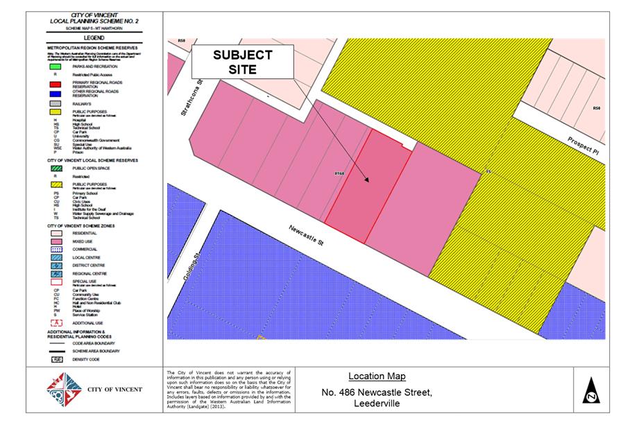
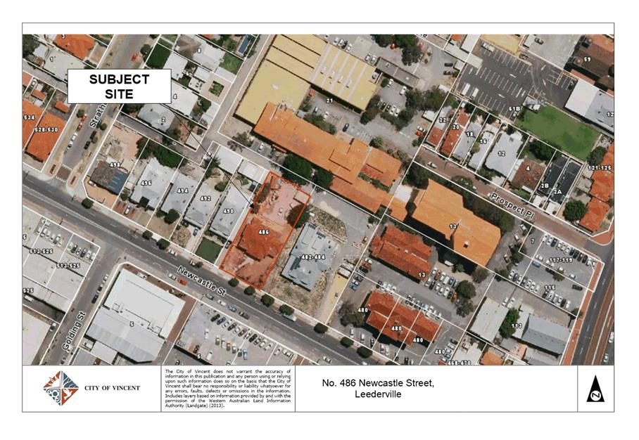
The subject site is zoned Mixed Use R160 under the City’s Local Planning Scheme No. 2 (LPS2), and is bound by Newcastle Street to the south-west, a ROW to the north-east, and Nos. 482-484 and No. 490 Newcastle Street to the south-east and north-west respectively. Both of these properties are also zoned Mixed Use R160 under LPS2, and consist of single-storey Single Houses. A location plan is included as Attachment 1. The subject site is located within the Activity Corridor Built Form Area under the City’s Policy No. 7.1.1 – Built Form (Built Form Policy). The subject site is subject to a six storey height limit under the Built Form Policy.
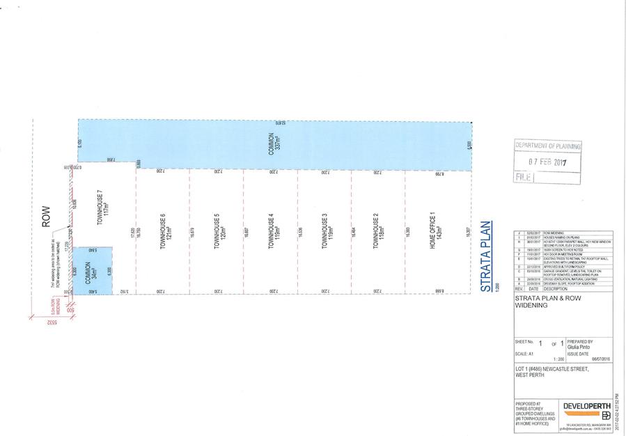
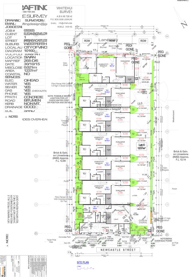
Subdivision Approval
On 7 February 2017, the Western Australian Planning Commission approved an application subject to conditions to subdivide the property into seven lots. A copy of the approved subdivision plan in included as Attachment 2. The landowner has not yet sought clearance of the conditions of subdivision approval.
Previous Development Approval
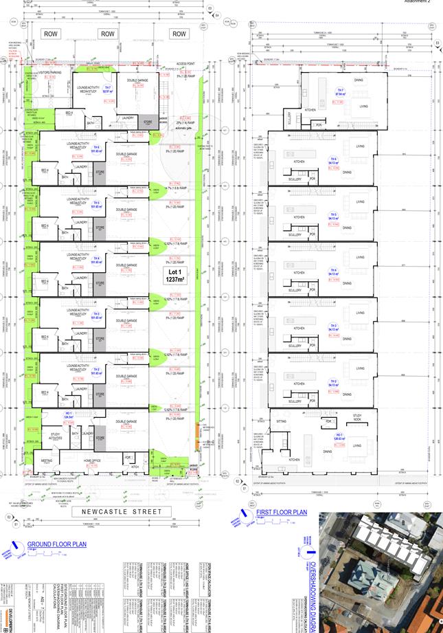
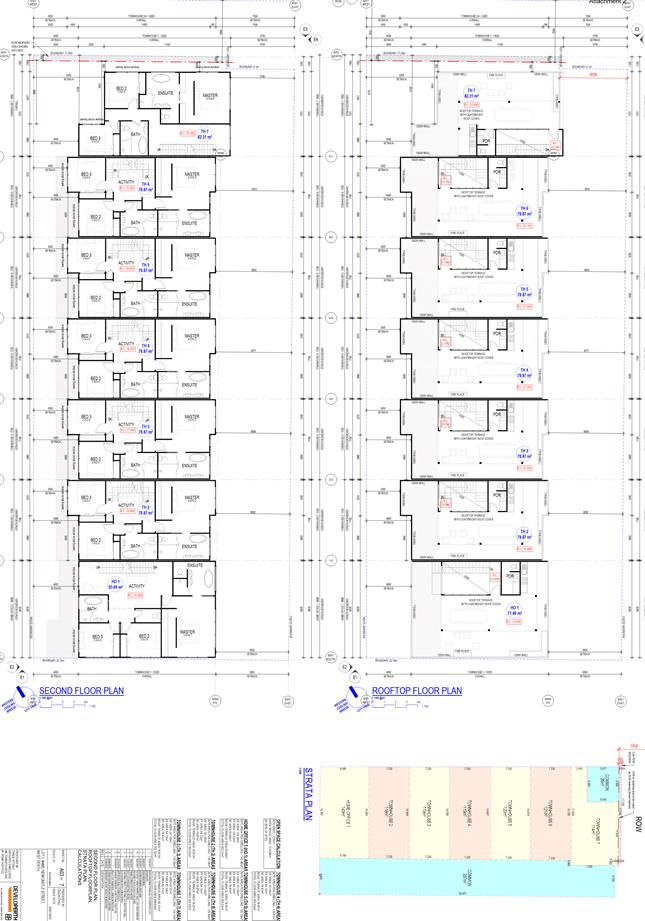
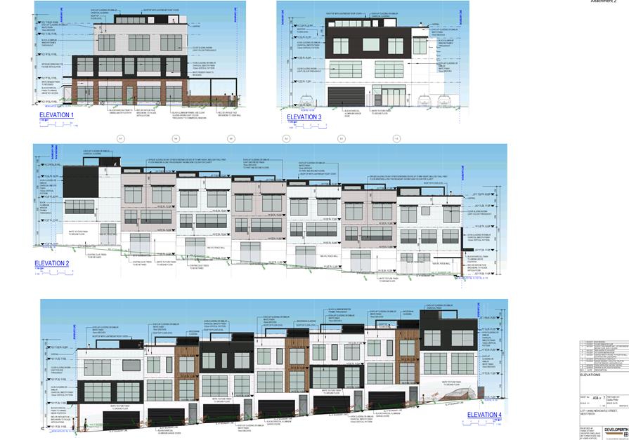
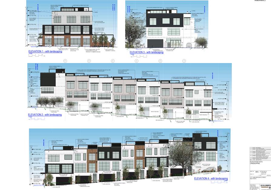
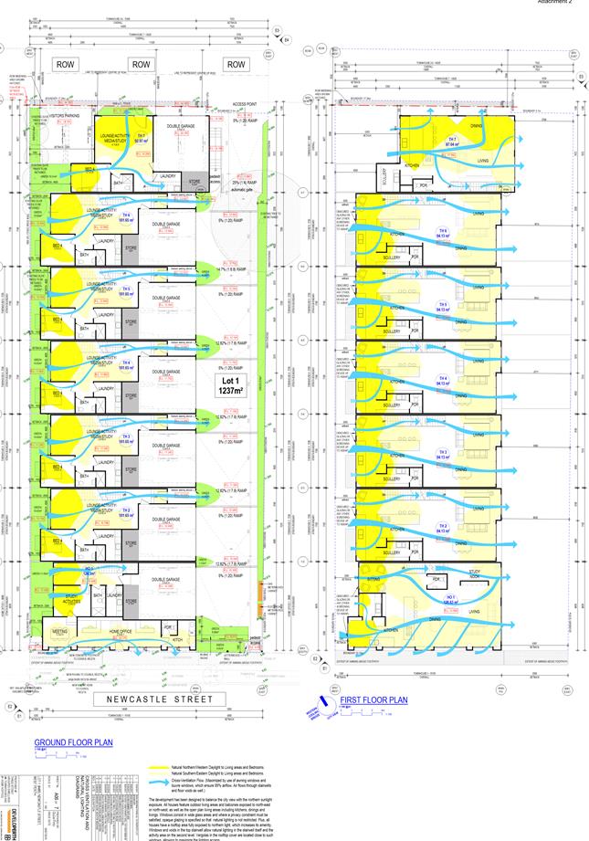
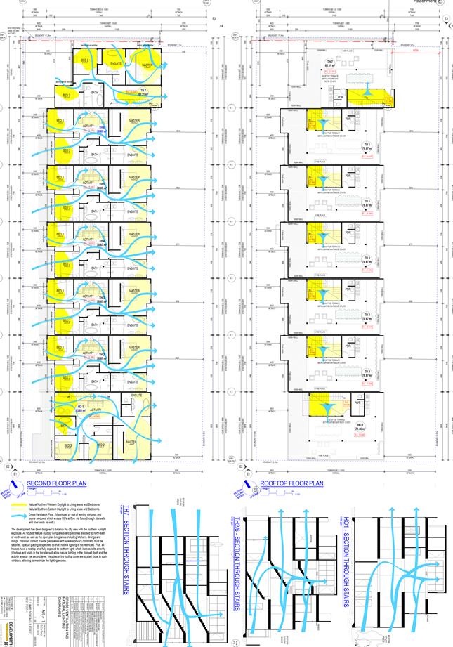
On 7 March 2017, Council resolved to approve a development application subject to conditions for Seven Grouped Dwellings and a Home Occupation (Office) at the subject site. The application consisted of:
· The demolition of the existing Single House and associated structures;
· Seven Grouped Dwellings with a maximum height of four storeys, and varying in size between 92.97 square metres and 124.3 square metres;
· A Home Occupation (Office) use incorporated into the front dwelling with an area of 29.82 square metres;
· 14 resident parking bays incorporated within double garages for each dwelling, and two visitor bays in the northwest corner of the site;
· Access provided by a common driveway provided from the ROW; and
· Landscaping provided on the ground floor.
An extract of the Council Minutes, including the plans is shown in Attachment 3. It should be noted that the development approval is consistent with the abovementioned subdivision approval.
Details:
The application proposes a two year extension of time to substantially commence the development of the previously approved Seven Grouped Dwellings and Home Occupation (Office). The current development approval is due to expire on 7 March 2019. The application does not propose any changes to the plans that were previously approved by Council.
The applicant has advised that the extension of time is being sought to allow time to secure presales in the current economic climate, which may take 10 to 11 months, and then progress with the required documentation for the Building Permit, which may take two to three months. The applicant has advised that they are applying for the extension of time now so as to avoid a situation whereby the current approval expires in the middle of this process. In accordance with Clause 77(1) of the Planning and Development (Local Planning Schemes) Regulations 2015 and application can be made to extend the terms of approval.
As part of the City’s review of the application, it was identified that the Home Occupation approved originally had an area of 29.82 square metres, which exceeds the area (20 square metres) referred to in the definition of the use under both the City’s previous Town Planning Scheme No. 1 (TPS1) and current LPS2. This matter will need to be resolved and is discussed later in the report.
Summary Assessment
The application has been assessed against the provisions of the City’s LPS2, Built Form Policy, and the WAPC’s Residential Design Codes (R Codes). In assessing the application, it has been identified that the proposal remains consistent with that previously approved by Council on 7 March 2017, and does not incorporate any changes. Therefore, it does not propose any new departures to LPS2, the Built Form Policy or the R Codes. This is because the R Codes stipulates that all standards for Grouped Dwellings within R160 coded areas as per the R80 coded areas.
Consultation/Advertising:
The previous application was advertised for a period of 14 days in accordance with the City’s Policy No. 4.1.5 – Community Consultation. At the conclusion of the consultation period, three submissions were received, one of which objected to the proposal and two of which provided comments. Following this, the applicant amended the plans to address the concerns raised in the submissions. The amended plans were then considered, and approved, by Council on 7 March 2017.
The current application was not advertised for public consultation, on the basis that it remains consistent with the plans previously approved by Council, and there are no modifications or further departures resulting from any changes to the planning framework, which is discussed further in the Comments section below. Whilst the issue of the Home Occupation will need to be addressed as part of the current application, given that (i) the practical nature and form of the use is not proposed to change from that which was previously approved and (ii) the Home Occupation was advertised as part of the original proposal, and no submissions were received in respect to this use, it was not considered necessary to readvertise the proposal on the basis of that issue.
Design Review Panel (DRP):
Referred to DRP: No
The previous application was referred to the DRP for comment on the aesthetics of the development and elevations to all boundaries. The applicant submitted amended plans to address the DRP comments, and these plans were subsequently approved by Council. As the application does not propose any changes or modifications to the built form which was previously approved, the subject application was not referred to the DRP for comment.
Legal/Policy:
· Planning and Development Act 2005;
· Planning and Development (Local Planning Schemes) Regulations 2015;
· City of Vincent Local Planning Scheme No. 2;
· State Planning Policy 3.1 – Residential Design Codes;
· Policy No. 4.1.5 – Community Consultation;
· Policy No. 7.1.1 – Built Form Policy; and
· Policy No. 7.5.9 – Home Business, Home Occupation and Home Store.
Delegation to Determine Applications:
In accordance with 6.2(13) of the City’s Delegated Authority Register 2018-2019, the application is required to be determined by Council, as the original development approval was determined by Council.
Risk Management Implications:
It is Administration’s view that there are minimal risks to Council and the City’s business function when Council exercises its discretionary power to determine a planning application.
Strategic Implications:
The City’s Strategic Plan 2013-2023 states:
“Natural and Built Environment
1.1 Improve and maintain the natural and built environment and infrastructure.”
SUSTAINABILITY IMPLICATIONS:
Nil.
Financial/Budget Implications:
Nil.
Comments:
In considering the acceptability of this application for an extension of time, Administration has considered the following:
1. Changes in the planning framework since development approval was granted;
2. Whether the development is likely to receive approval now; and
3. Whether the applicant has actively and relatively conscientiously pursued the implementation of the development.
This is discussed in further detail below.
1. Changes to the planning framework
City of Vincent Local Planning Scheme No. 2
The previous application for the subject site was assessed under the City’s Town Planning Scheme No. 1 (TPS1). Since the previous application was approved, the City’s LPS2 was gazetted on 16 May 2018. LPS2 rezoned the subject site from Residential R80 under TPS1 to Mixed Use R160.
State Planning Policy 3.1 Residential Design Codes
Despite the subject site being recoded from R80 under TPS1 to R160 under LPS2, there is no change to the R Codes requirements applicable to the proposal. Table 1 of the R Codes identifies that all standards for Grouped Dwellings within R160 area are as per the R80 code. In this regard, there is no change to the applicable requirements of the R Codes for the proposal.
2. Whether the development is likely to receive approval now
In considering whether the proposal would likely receive approval under the current planning framework, the following is noted:
· There are no new changes or modifications to the previously approved plans proposed as part of this application;
· The acceptability of the previously identified variations to the applicable deemed-to-comply requirements of the Built Form Policy and R Codes for the development has previously been considered and approved by Council;
· Since the previous approval, the City’s LPS2 has been gazetted which rezoned the subject site. Both Grouped Dwellings and Home Occupation are permitted ‘P’ uses within the Mixed Use zone. The subject site is not affected by either Clause 26 or 32 of LPS2, which modifies the R Codes and includes additional Scheme requirements; and
· The gazettal of LPS2 also recoded the subject site. The standards applicable to R160 are the same as those applicable to R80, and therefore there is no change to the development requirements of the proposal.
In light of the above, the proposal would be supported under the current planning framework, although it is noted that under the land use definitions in LPS 2, a home-based commercial activity that occupies an area of between 20 and 50 square metres is a Home Business, and not a Home Occupation.
The main discrepancy between the Home Occupation and Home Business uses is the car parking requirements. Under the City’s Policy No. 7.5.9 – Home Business, Home Occupation and Home Store, a Home Occupation should not require a greater number of parking facilities than normally required for a dwelling. For a Home Business, two dedicated on-site car bays are required. In addition to the one bay required for the associated Grouped Dwelling under the R Codes, a total of three bays are required. The proposal involves the provision of a double garage for Unit 1, resulting in a one bay variation.
In considering this matter, the following is relevant:
· The nature of the home-based commercial activity is not proposed to change, and will be operated by the resident of the dwelling, as was previously proposed and approved;
· The home-based commercial activity is only nine square metres larger than what would be a Home Occupation;
· It is expected that the business aspect would likely operate during normal work hours (9:00am to 5:00pm Monday to Friday), when visitors to the dwellings would be less likely. This would potentially enable the proposed visitor bays to be used, if required; and
· The subject site approximately 45 metres from bus stops located on either side of Newcastle Street, as approximately 660 metres from the nearest CAT bus stop located within the City of Perth. Given the location of the subject site on the fringe of the Perth Central Business District, it is considered that there is sufficient public transport options available.
Based on the above, the proposed variation is considered acceptable and therefore the proposal would be supported under the current planning framework.
3. Implementation of the development
The applicant has advised the following steps have been taken to implement the development since approval was granted on 7 March 2017:
“To implement the development we have spent a few months trying to secure the finance through a construction loan and private investments. Adverse economic conditions have slowed us considerably. Now we are ready to go to the market as real estate agents have advised that there is consistent demand for this product but still it might be a lengthy process, approx.10-11 months to pre-sell the majority of them. We spent the last few months producing the advertisement material to go on the market and trying to secure some presales.”
It is considered that the applicant has made an effort to progress their development approval and will be able to achieve at least some further progress before the approval is due to expire in March 2019.
Conclusion
On 29 August 2018, the City received an application to extend the period in which to substantially commence the development of Seven Grouped Dwellings and Home Occupation (Office) at No. 486 Newcastle Street, Leederville. The application does not propose any changes to the plans previously approved by on 7 March 2017, and remains consistent with the current planning framework. As noted, the City’s assessment has identified that the Home Occupation use was incorrectly approved, and should have been considered as a Home Business, which it recommends be corrected. The applicant has sought to implement their previous approval, and is seeking an additional two years for which to substantially commence development as a result of difficulty securing presales in the current economic climate. In light of the above, the application is supported, subject to the same conditions previously imposed being suitably modified.
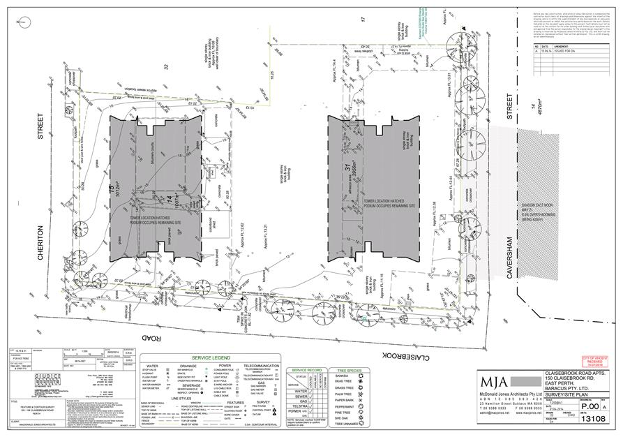
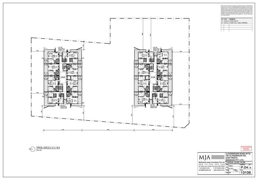
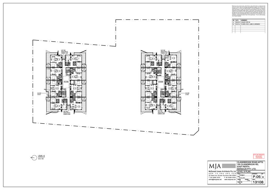
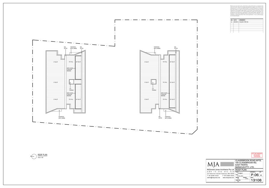
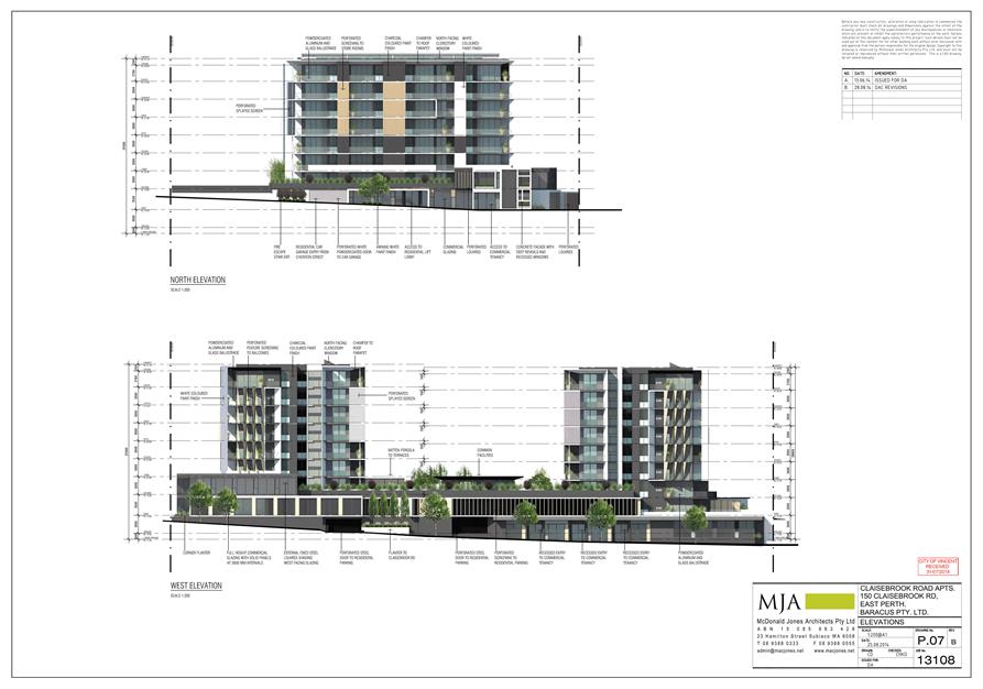
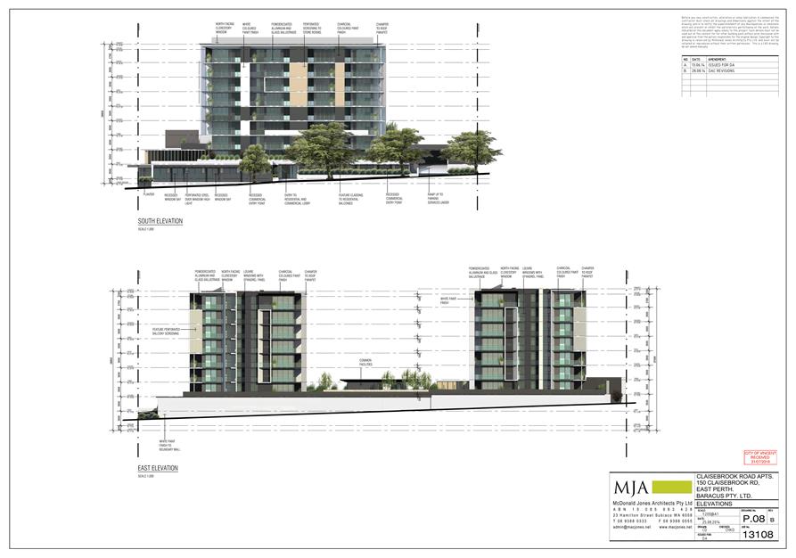
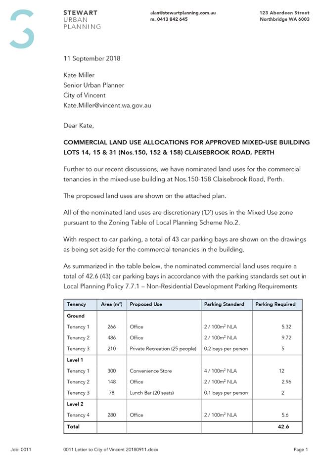
5.3 Nos. 150, 152 and 158 (Lot: 31, 15 and 14; D/P: 73062, 14 and 28) Claisebrook Road, Perth - Amendment to Approval for Mixed Use Development comprising seven commercial tenancies and 116 Multiple Dwellings
TRIM Ref: D18/132895
Author: Kate Miller, Senior Urban Planner
Authoriser: Luke Gibson, A/Director Development Services
Attachments: 1. Attachment
1 - Consultation and Location Map ⇩ ![]()
2. Attachment
2 - Development Plans ⇩ ![]()
3. Attachment
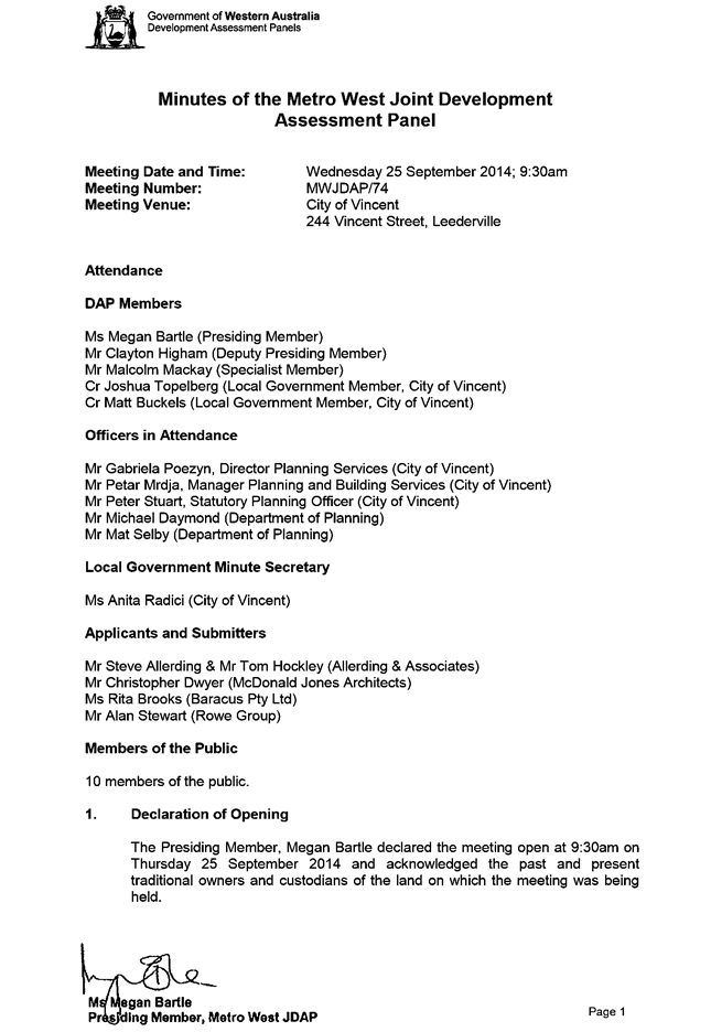
3 - Development Assessment Panel Minutes 25 September 2014 ⇩ ![]()
4. Attachment
4 - Development Assessment Panel Minutes 18 August 2016 ⇩ ![]()
5. Attachment
5 - Applicant's Planning Report ⇩ ![]()
6. Attachment
6 - Design Review Panel Minutes (5 September 2018) ⇩ ![]()
7. Attachment
7 - Environmentally Sustainable Design Report ⇩ ![]()
|
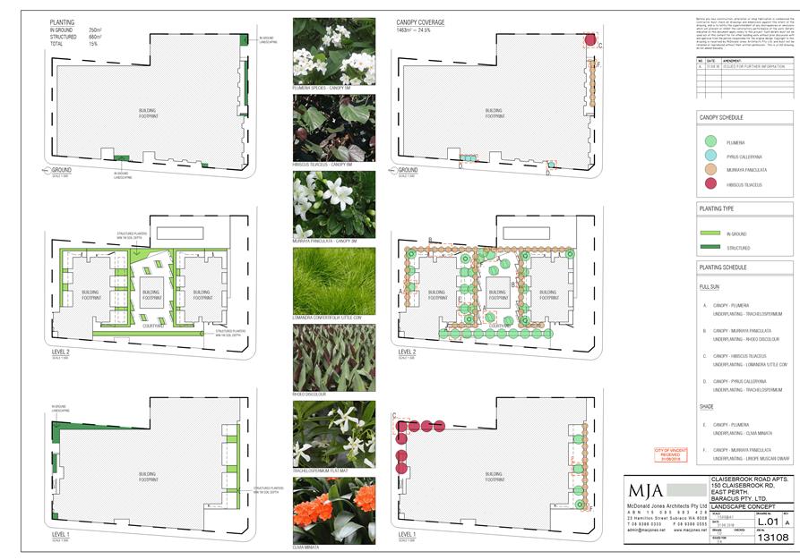
That Council, in accordance with the provisions of the City of Vincent Local Planning Scheme No. 2 and the Metropolitan Regional Scheme APPROVES the application to amend the development approval for Mixed Use Development at Nos. 150, 152 and 158 (Lots 31, 15 and 14) Claisebrook Road, Perth, granted on 25 September 2014, in accordance with the plans shown in Attachment 2, subject to the following: 1. Unless otherwise noted, all conditions, requirements and advice notes detailed on the previous approval dated on 25 September 2014 (and subsequently amended on 18 August 2016) continue to apply to this approval; 2. Condition 2 (requiring demolition of the former buildings) is to be deleted; 3. Condition 3 is to be amended as follows: “3.1 A minimum of 40 parking bays for the commercial tenancies, 116 parking bays for the multiple dwellings and 29 parking bays for use of visitors is to be provided; 3.2 A minimum of two motor cycle/scooter bays is to be provided; and 3.3 A minimum of 21 bicycle bays is to be provided”; 4. The addition of a new Condition 4.6 as follows: “4.6 Prior to issuing a Building Permit, the applicant is to submit amended plans demonstrating compliance with the deemed-to-comply requirements of Clause 6.2.3 (Sight lines) of the Residential Design Codes, to the satisfaction of the City of Vincent”; 5. The addition of a new Condition 6.1.4 as follows: “6.1.4 Prior to issuing a Building Permit, an amended landscaping plan demonstrating 24.5 percent of canopy coverage at maturity is to be provided on site. The landscaping is to be provided on site prior to occupation of the development and maintain thereafter, to the satisfaction of the City of Vincent”; 6. The addition of a new Condition 10 as follows: “10 Prior to the issuing of a Building Permit, the applicant is to submit amended plans demonstrating the raised terraces on level 2 of the northern building are screened in accordance with the deemed-to-comply requirements of Clause 6.4.1 (Visual privacy) of the Residential Design Codes, to the satisfaction of the City of Vincent”;
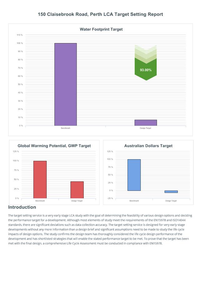
7. The addition of a new Condition 11 as follows: “11 Prior to the issuing of an Occupancy Permit, the Applicant must implement the recommendations of the submitted Environmentally Sustainable Design Report so as to achieve a minimum 50 percent greenhouse gas reduction and 25 percent water reduction. All initiatives must be maintained for the duration of the development, to the satisfaction of the City”; and 8. The addition of a new Condition 12 as follows: “12 This decision constitutes development approval only and is valid until 13 November 2021. If the subject development is not substantially commenced within this period, the approval shall lapse and be of no further effect”. |
Purpose of Report:
To consider an application for development approval for an extension of time to substantially commence development of the previously approved Mixed Use Development at Nos. 150, 152 and 158 Claisebrook Road, Perth (subject site).
Background:
|
Landowner: |
Baracus Pty Ltd |
|
Applicant: |
Alan Stewart |
|
Date of Application: |
31 July 2018 |
|
Zoning: |
MRS: Urban LPS2: Zone: Mixed Use R Code: R100 |
|
Built Form Area: |
Mixed Use |
|
Existing Land Use: |
Hostel |
|
Proposed Use Class: |
Mixed Use Development (six commercial tenancies and 116 multiple dwellings) |
|
Lot Area: |
5,975m² |
|
Right of Way (ROW): |
Not applicable |
|
Heritage List: |
No |
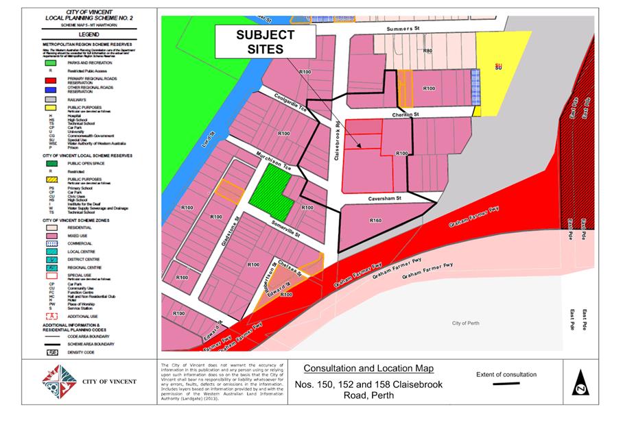
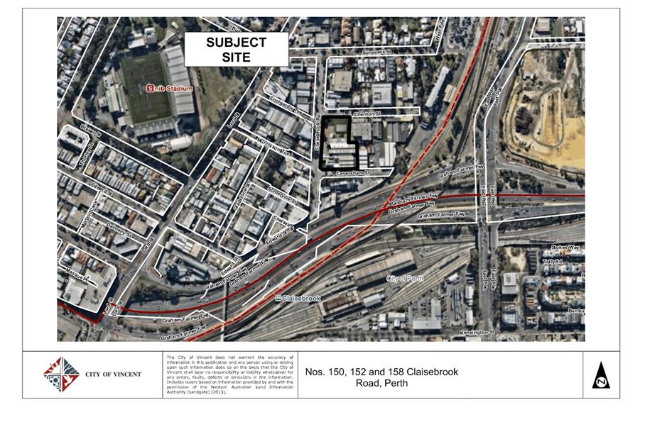
The subject site is located at Nos. 150, 152 and 158 Claisebrook Road, Perth, as shown on the location plan included as Attachment 1. The site is vacant and bound by Cheriton Street to the north, Caversham Street to the south and Claisebrook Road to the west. The site is also adjacent to commercial development comprising an Office and vacant building to the east. The opposite side of Claisebrook Road (between Murchison Terrace and Coolgardie Terrace) comprises a vacant building, a single house and 15 multiple dwellings and the southern side of Caversham Street accommodates the Holcim concrete batching plant. The subject site and all surrounding development is zoned Mixed Use R100 the City’s Local Planning Scheme No. 2 (LPS2).
Previous Development Approval
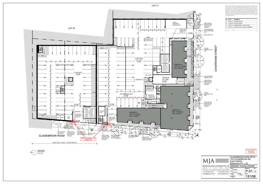
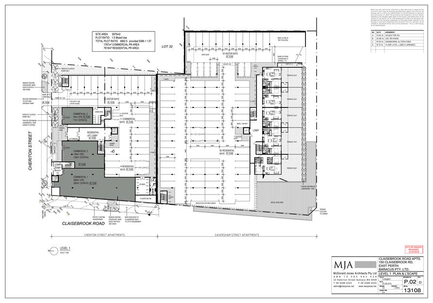
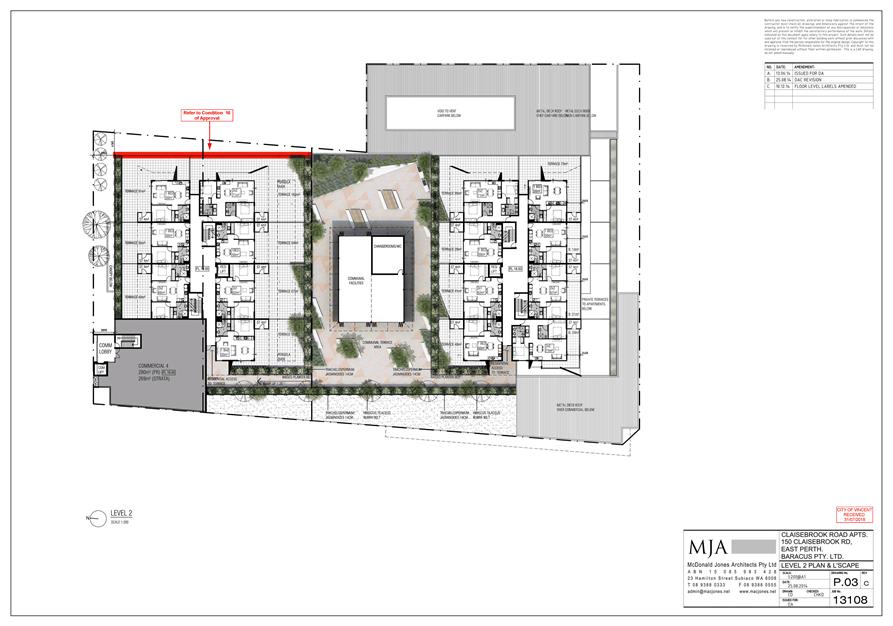
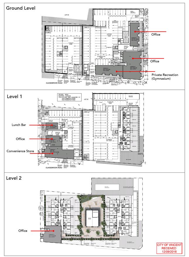
The development comprises two separate buildings, which contain a total of seven commercial tenancies and 116 multiple dwellings. The northernmost building contains four commercial tenancies and 55 multiple dwellings and the southernmost building contains three commercial tenancies and 61 multiple dwellings. Vehicle parking is proposed within the ground floor and level one of the development. Communal space is provided centrally between the towers on level two of the development. The development plans, as previously approved, are included as Attachment 2.
The application was originally presented to the Metro West Joint Development Assessment Panel (JDAP) on 25 September 2014 (JDAP Ref 14/00561). The JDAP resolved to approve the application. A subsequent application was presented to the JDAP on 18 August 2016, seeking to extend the term of approval for a further two years. The JDAP resolved to approve the application, extending the approval until 25 September 2018. The minutes of the two JDAP meetings are included as Attachment 3 and Attachment 4.
The abovementioned JDAP applications were assessed under the East Perth Redevelopment Authority Scheme No. 1 (EPRA Scheme), however, the City’s Local Planning Scheme No. 2 (LPS2), which was gazetted on 16 May 2018, served to supersede the EPRA Scheme. The subject application is therefore required to be considered under the current planning framework.
The subject application was lodged with the City for the purpose of extending the term of approval by a further three years. In accordance with Clause 77(1) of the Planning and Development (Local Planning Scheme) Regulations 2015 an application can be made to the local government to extend the term of approval. Subclause (2)(b) permits the application to be made during or after the period within which the development approved must be substantially commenced.
In accordance with Regulation 17A of the Development Assessment Panel Regulations 2011, the applicant has requested the City of Vincent determines the application in lieu of the JDAP.
Details:
The application proposes a three year extension to substantially commence development of the previously approved Mixed Use Development. No changes are proposed to the previously approved development plans.
The applicant has provided justification in support of the proposed extension of time, which is summarised as follows:
· Commencement of development has been delayed due to the uncertainty of the existing concrete batching plants located at Nos. 120 Claisebrook Road and 71 Edward Street.
· The concrete batching plants are considered to have caused urban blight and resulted in undesirable market conditions which did not provide high confidence for the developers in terms of sale of apartments. Notwithstanding, the gazettal of LPS2 provides certainty that future development within the surrounding locality will transition from commercial and industrial land uses to the intended mixed use land uses.
· At the time of submission, it was noted the term of approval for the concrete batching plants was being reviewed by the Minister for Planning, with another temporary approval likely to be granted to allow sufficient time for the plants to be appropriately relocated. Since that time, the Minister has made such a decision which provides further confidence the future of the subject locality is a high density mixed use precinct, without the concrete batching plants.
· It is considered approval of the extension of term for the subject application will allow sufficient time for the development to be constructed, with completion of the development coinciding with the end of term of the concrete batching plants. It is considered this will provide more favourable market conditions for the development.
The Applicant’s submission in support of the application is included as Attachment 5.
Consultation/Advertising:
The previous application was advertised for a period of 14 days in accordance with the City’s Policy No. 4.1.5 – Community Consultation. At the conclusion of the consultation period, three submissions were received, one of which objected to the proposal and two of which provided comments. The objections raised concerns in relation to the applicable planning framework and the acoustic report provided, noting no comments were raised in relation to the built form of the proposal. The application was considered and approved at the JDAP meeting on 25 September 2014.
Given the changes to the planning framework, the application was readvertised in accordance with the City’s Policy No. 4.1.5 – Community Consultation, for a period of 14 days from 10 October 2018 to 24 October 2018. The method of consultation being 23 letters mailed to all owners and occupiers surrounding the site (as shown in Attachment 1), in accordance with the City’s Policy No. 4.1.5 – Community Consultation.
In response, one submission was received, which was in support of the proposal.
Design Review Panel (DRP):
Referred to DRP: Yes
The original proposal was previously considered by the City’s (then) Design Advisory Committee on 16 July 2014 and 3 September 2014. The proposal was awarded Design Excellence and for this reason, the application was not referred to the DRP as part of the Form 2 application extension of time that was approved on 18 August 2016.
Due to the time since the original approval, the current application was referred to the City’s Design Review Panel (DRP) in September 2018. The DRP confirmed the development was of a high standard and comments from the previous meetings remain valid. In addition, the DRP provided additional comments for consideration, noting these have no significant impact on the design of the development.
In summary, the DRP confirmed they are supportive of the proposed development and the additional comments, included as Attachment 6 are suggestions for the applicant’s consideration only.
Legal/Policy:
· Planning and Development Act 2005;
· Planning and Development (Local Planning Schemes) Regulations 2015;
· Planning and Development (Development Assessment Panels) Regulations 2011 (JDAP Regulations);
· City of Vincent Local Planning Scheme No. 2;
· State Planning Policy 3.1 – Residential Design Codes (R Codes);
· Policy No. 4.1.5 – Community Consultation;
· Policy No. 7.1.1 – Built Form (Built Form Policy); and
· Policy No. 7.7.1 – Non Residential Development Parking Requirement.
In accordance with Schedule 2 Clause 77 (1) of the Planning and Development (Local Planning Schemes) Regulations 2015 and Part 14 of the Planning and Development Act 2005, the applicant will have the right to apply to the State Administrative Tribunal for a review of Council’s determination.
delegation to determine applications:
This matter is being referred to Council as the development proposes a mixed use development, being nine storeys in height.
Risk Management Implications:
It is Administration’s view that there are minimal risks to Council and the City’s business function when Council exercises its discretionary power to determine a planning application.
Strategic Implications:
The City’s Strategic Plan 2013 – 2023 states:
“Natural and Built Environment
1.1 Improve and maintain the natural and built environment infrastructure.”
SUSTAINABILITY IMPLICATIONS:
Nil.
Financial/Budget Implications:
Nil.
Comments:
In considering the subject application for an extension of time, the City has considered the following:
1. Changes in the planning framework since development approval was granted;
2. Whether the development is likely to receive approval now; and
3. Whether the applicant has actively and relatively conscientiously pursued the implementation of the development.
This is discussed in further detail below. The applicant has addressed the above matters within the planning report provided as Attachment 5.
1. Changes to the planning framework
City of Vincent Local Planning Scheme No. 2
The previous application for the subject site was assessed under the EPRA Scheme and associated policies. The EPRA Scheme did not provide land use zoning for the redevelopment area. However, precincts were created and the lots were to be developed in accordance with the Statement of Intent. The subject sites were located within Precinct 15: Claisebrook Road North, and the Statement of Intent was as follows:
“Within this Precinct, commercial, retail, service and light industrial uses compatible with residential use will be supported, including uses providing services to the businesses and residents of the central and inner city.
The Authority intend that there should be an improvement in the general level of amenity in the Precinct, with the improved presentation and maintenance of private properties and the public domain, and a progressive reduction in the incidence of those industrial activities incompatible with other uses, including residential development.”
It is noted that the EPRA Scheme outlined “Preferred” and “Contemplated” land uses. The application incorporated “Preferred” land uses.
The City’s LPS2 was approved by the Minister and was subsequently gazetted on 16 May 2018. LPS2 identifies the subject site as Mixed Use R100. Compliance with the objectives of the Mixed Use zone is discussed under the relevant headings below.
Built Form Policy and State Planning Policy 3.1 Residential Design Codes
Since the JDAP’s decision to approve the original development application in 2014 and subsequent application for an extension of time in 2016, the planning framework has changed, including changes to the Residential Design Codes (R Codes) and the adoption of the City’s Built Form Policy. Under the Built Form Policy, the subject sites are located within the Mixed Use built form area. The identified departures to the deemed‑to‑comply provisions of the Built Form Policy and the R Codes are discussed under the relevant heading below. This assists in establishing whether the application would be supported under this current planning framework.
Existing Concrete Batching Plants
The existing concrete batching plants are located at No. 120 Claisebrook Road, Perth and No. 71 Edward Road, Perth. The gazettal of the City’s LPS2 rezoned the subject sites to Mixed Use R160 and provided an Additional Use (concrete batching plants) until 30 June 2024.
The previous approval for the concrete batching plants limited the term of approval until 16 October 2018. On 10 October 2018, the Minister for Planning granted approval for the batching plants to continue operation until 30 June 2024, so as to align with LPS 2 and to allow sufficient time for the concrete batching plants to relocate to a more appropriate site.
The recent approval is consistent with the applicant’s justification in that the concrete batching plants are to be relocated at or prior to June 2024. It is considered to time extension of the subject application will allow for the construction of the proposed development to align with the relocation of the concrete batching plants.
2. Whether the development is likely to receive approval now
The application proposes no changes to the previously approved development plans., however, given there has been substantial changes to the planning framework, reassessment of the proposal is required.
The below table details where discretion is required against the current planning framework in comparison to the previous planning framework. Where planning elements are not mentioned below, they are considered to satisfy the deemed to comply requirements of the current planning framework.
|
Planning Element |
Previous Planning Framework (EPRA Scheme) |
Current Planning Framework (LPS2) |
||
|
Complies ‘Deemed to Comply’ |
‘Design Principles’ Assessment |
Complies ‘Deemed to Comply’ |
‘Design Principles’ Assessment |
|
|
Land Use |
ü |
|
|
ü |
|
Plot Ratio |
|
ü |
|
ü |
|
Setbacks |
ü |
|
|
ü |
|
Tenancy size |
ü |
|
|
ü |
|
Landscaping |
ü |
|
|
ü |
|
Vehicle access |
ü |
|
|
ü |
|
Visual privacy |
ü |
|
|
ü |
|
Dwelling size |
ü |
|
|
ü |
|
Environmentally Sustainable Design |
N/A |
N/A |
|
ü |
As detailed within the table above, discretion is required for the proposed land uses, plot ratio, setbacks, tenancy size, landscaping and dwelling diversity. As such, the proposed development has been considered against the relevant objectives and design principles below.
Mixed Use Zone
The application previously obtained approval by the JDAP for “Preferred” uses as identified by the EPRA Scheme, noting the uses were not explicitly stated. The subject application proposes Multiple Dwellings, Convenience Store, Lunch Bar, Office and Private – Recreation (Gymnasium) land uses. Multiple Dwellings are ‘P’ permitted and all of the commercial land uses are ‘D’ discretionary land uses under the City’s LPS2. The commercial land uses are assessed against the objectives of the Mixed Use zone, which are as follows:
· To provide for a wide variety of active uses on street level which are compatible with residential and other non-active uses on upper levels.
· To allow for the development of a mix of varied but compatible land uses such as housing, offices, showrooms, amusement centres, eating establishments and appropriate industrial activities which do not generate nuisances detrimental to the amenity of the district or to the health, welfare and safety of its residents.
· To provide for a compatible mix of high density residential and commercial development.
· To promote residential use as a vital and integral component of these mixed use zones.
· To ensure development design incorporates sustainability principles, with particular regard to waste management and recycling and including, but not limited to, solar passive design, energy efficiency and water conservation.
· To ensure the provision of a wide range of different types of residential accommodation, including affordable, social and special needs, to meet the diverse needs of the community.
The subject locality currently comprises a mix of residential, commercial and industrial land uses. The application proposes mixed use development comprising of commercial tenancies on the ground floor and on level one of the building, and multiple dwellings above. It is considered the proposed land uses will be compatible with the residential dwellings and will service the needs of the surrounding locality. The surrounding land is also zoned Mixed Use R100 and is therefore likely to result in a similar type of development.
The subject site is bounded by three local roads to the north, south and west and the application proposes each of the commercial tenancies address at least one local road. The location of the commercial tenancies is considered to activate the site, whilst providing separation to other adjoining sites. This is considered to reduce potential impact of the land uses on surrounding development. In addition, the application complies with site requirements such as adequate parking facilities to ensure the development does not cause adverse impacts to surrounding development.
Plot ratio
Under the EPRA Scheme, a maximum plot ratio of 1.5 was permitted however, under the City’s LPS2 and associated R Codes, a maximum plot ratio of 1.25 is permitted. The application proposes a plot ratio of 1.253 (7,500.70 square metres), thereby exceeding the permitted plot ratio area by 23.7 square metres. In considering this variation, the following is relevant:
· the application involves nine stories in lieu of the 10 that is permitted under the City’s Built Form Policy
· the application proposes two separate buildings which are adequately setback from each other, the street and the lot boundaries
· the
building bulk and scale is consistent with the desired built form of the
locality.
· the variation equates to 0.2 square metres per apartment
Based on the above, the minor variation is considered acceptable.
Setbacks
The City’s Built Form Policy requires that where buildings adjoin non-residential Built Form areas, level three and above are to have a minimum setback of 4 metres from the lot boundary. The application proposes level three and above of the northern building to be setback 3.7 metres from the eastern lot boundary.
The reduced setback relates to a 0.8 metre length of wall, noting the remainder of the building is setback 5.1 metres from the eastern lot boundary. The reduced section of wall is considered a design element which adds articulation to the building and assists in reducing impacts of building bulk on the undeveloped adjoining properties. The setback variation satisfies the relevant design principles of the City’s Built Form Policy and therefore is supported.
Tenancy Size
The City’s Built Form Policy requires ground floor spaces to have a width of between 7.5 metres and 9 metres, to create regular entrances with active frontages. The application proposes tenancies one and three of the northern building with a width of 10.3 metres and 6.3 metres, respectively and the southern building proposes tenancies one, two and three to have widths of 27.1 metres, 27.7 metres and 22.8 metres, respectively.
As previously mentioned, the subject site is bound by three local roads. The increased tenancy widths ensures all street frontages remain activated in accordance with the design principles of the Built Form Policy. The tenancies are considered to provide regular entrances which increase the interest and engagement of pedestrians and improve walkability and vibrancy. Furthermore, the tenancies located on the street corners address both streets which is considered to minimise ‘dead’ spaces and increase visibility between the building and the street and vice versa. It is also considered the varying tenancy size ensures a mix of land uses can be accommodated on site.
As the tenancy size variations are considered to satisfy the relevant design principles of the City’s Built Form Policy, the variation is supported.
Landscaping
Condition 6.1.3 of the JDAP’s approval on 25 September 2014 required the preparation of a landscaping plan, although the condition did not detail any specific requirements.
The Built Form Policy requires 15 percent of the site to be set aside for deep soil zones and 80 percent of the rear or side setback area to be provided as canopy cover at maturity. The development incorporates 15.2 percent deep soil zones, 42.2 percent of the rear setback area provided as canopy cover at maturity and 11.6 percent canopy is provided over the entire site. The applicant has confirmed, however, that the canopy cover can be increased to 24.5 percent by using the proposed deep soil zones and has agreed to such condition being imposed.
The landscaping is strategically located within the communal space between the buildings and along the street boundaries. Whilst the development does not achieve 80 per cent of the rear setback area being provided as canopy cover at maturity, the setback and separation of the building will minimise impact of building bulk and mass on the adjoining properties. Therefore, it is considered the proposed landscaping locations will be effective in contributing to the visual amenity for residents and occupants and in reducing the impact of the development on adjoining properties and the street. Additionally, all planting areas are provided with ground cover. Whilst the ground cover is not included as canopy cover, it is considered the planting will positively contribute to the visual amenity of the development. Furthermore, Administration is satisfied that the species proposed meet the City’s requirements in terms of water wise plant and tree selection.
The application also proposes to retain 11 of the 12 existing verge trees. Whilst the verge trees do not contribute to the canopy cover on site, the retention of the existing verge tree along Cheriton Street, Claisebrook Road and Caversham Street will further contribute to the intended landscaping outcome for this development.
For these reasons, it is considered that the development satisfies the design principles of landscaping requirements contained in the Built Form Policy.
Vehicle Access and Parking
The City’s Built Form Policy permits a maximum of one crossover per lot with a maximum width of 5 metres. The application proposes four crossovers, with one on Cheriton Street, one on Caversham Street and two on Claisebrook Road. All of the crossovers are proposed to be 6 metres wide.
Multiple crossovers spread over three streets will reduce the number of vehicles accessing and egressing an individual access way of the site. The reduced traffic volumes per access way will provide a safer environment for pedestrians.
It is also noted both crossovers along Claisebrook road do not achieve unobstructed sightlines in accordance with the deemed-to-comply requirements or design principles of Clause 6.2.3 (Sightlines) of the R Codes, due to the booster and pump rooms being proposed in these locations. This variation was not identified as a variation within previous applications and was therefore approved. Notwithstanding, a condition is recommended to ensure the development will provide unobstructed sightlines and therefore improve safety for pedestrians.
Visual Privacy
The R Codes requires raised outdoor living areas to be provided with a 6 metre cone of vision setback or the provision of some form of physical screening. The application proposes the raised terraces of the northern building to be setback between 1.5 metres to 4 metres from the eastern lot boundary.
Visual privacy was not identified as a variation as part of the previous applications. Notwithstanding, to ensure the development does not result in direct overlooking of active habitable spaces of the adjoining site, Administration recommends a condition be imposed to require the development to be screened in accordance with the deemed-to-comply requirements of Clause 6.4.1 (Visual Privacy) of the R Codes.
Dwelling Size
The R Codes permits a maximum of 50 percent (58 units) of the dwelling mix to be provided as one bedroom dwellings. The application proposes 59 one bedroom dwellings, which represents 50.9 per cent.
The application proposes a mix of single bedroom and two bedroom dwellings. It is considered the additional one bedroom dwelling is a minor variation and a suitable mix of dwellings is provided, in terms of both type and size. For these reasons, the proposed variation is supported.
Environmentally Sustainable Design
The City’s Built Form Policy requires an Environmentally Sustainable Design (ESD) Report to be submitted, demonstrating the following:
P1.8.1 It maximises passive solar heating, cooling, natural ventilation and light penetration to reduce energy consumption;
P1.8.2 It is capable of recovery and re-use of rainwater, storm water, grey water and/or black water for non-potable water applications;
P1.8.3 Climate moderation devices can be incorporated to reduce passive solar gain in summer and increase passive solar gain in winter; and
P1.8.4 The development is capable of either achieving (i) a 5 star Green Star rating or (ii) a 50% reduction in global warming potential and a 25% reduction in water use.
The applicant has provided an ESD report to address the above provisions, which is included as Attachment 7. This Report lists the design strategies that will achieve the proposed greenhouse gas reduction and water use targets, and is considered to address the design principles and local housing objectives of Clause 1.8 of the Built Form Policy.
It is recommended that a condition be imposed requiring the submitted ESD report to be implemented.
3. Implementation of the development
As set out in Attachment 5, the applicant is seeking a time extension as they have not been able to commence the development due to the continued use of the concrete batching plants and unsuitable market conditions. The applicant has advised that the following has been undertaken to date and notes the delays in commencing construction:
· Closing the former backpacker hostel on the site;
· Commissioning the Project Architect to progress the detailed design and documentation of the project; and
· Obtaining preliminary cost estimates from prospective builders.
Whilst Administration does not consider substantial efforts have been made to progress the implementation of the development in the four years since approval was originally granted, it is considered the development reasonably satisfies the requirements of the applicable planning framework and should be considered on its merits, particularly given the impact of the concreate batching plant on the south side of Caversham Street.
Conclusion:
On 31 July 2018 the City received a Form 2 application for the subject site which sought a three year time extension to substantially commence the development.
The application has been assessed against the City’s LPS2, Built Form Policy, R Codes and the departures to the deemed-to-comply requirements have been identified above. For the reasons detailed above, the said variations are considered to meet the relevant design principles set out in the R Codes and local housing objectives set out in the Built Form Policy.
Administration is supportive of this application and recommends that the Form 2 application for Nos.150, 152 and 158 Claisebrook Road, Perth, be approved subject to conditions.
TRIM Ref: D18/159072
Author: Craig Wilson, Manager Asset & Engineering
Authoriser: Andrew Murphy, Director Engineering
Attachments: 1. Plan
No. 3492-PP-01 ⇩ ![]()
2. Plan
No. 3493-PP-01 ⇩ ![]()
|
That Council: 1. APPROVES the following minor parking restriction improvements and amendments: 1.1 the introduction of a 2P 8.00am to 5.30pm Monday to Friday parking restriction on the eastern side of Smith Street, Highgate, between Broome and Lincoln Streets, as shown on Plan No. 3492-PP-01 (Attachment 1); and 1.2 an on-road Loading Zone in Bourke Street, Leederville, adjacent 250 Oxford Street, as shown on Plan No. 3493-PP-01 (Attachment 2); and 2. NOTES that Administration will advise residents and businesses directly impacted by these minor parking restriction improvements and amendments. |
Purpose of Report:
To consider improvements/amendments to parking arrangements at various locations throughout the City of Vincent as detailed in the report.
Background:
The City regularly receives requests for the introduction of, or changes to, parking restrictions in both residential and commercial areas. Administration generally undertakes a range of investigations including parking demand and traffic volume surveys to assess traffic and on-street parking conditions. The data is then used to determine whether new or amended restrictions are warranted to improve parking availability and amenity. Where changes are considered justifiable a report is then presented to Council for consideration as Administration does not have delegated authority to make such changes.
Details:
A number of parking issues have recently been identified and investigated with details provided below.
Smith Street, Highgate
Smith Street, Highgate is classified as a Local Distributor Road under the Metropolitan Functional Road Hierarchy and is a continuation of Curtis Street, providing a direct link between Walcott Street and Bulwer/Brisbane Streets.
Given its location and close proximity to a number of attractions such as the Highgate / Mt Lawley commercial precinct, ‘nib Stadium’, high frequency bus services to the CBD, as a well as number of local businesses, parking is always in high demand, particularly in the unrestricted sections.
The current restrictions in Curtis and Smith Streets vary by ‘block’. Curtis Street has minimal parking, other than a small area of embayed parking near Harold Street, as the remainder of the street is too narrow too accommodate on-road parking. Smith Street, between Harold and Broome Streets, has time restrictions on the western side only, 2P 8.00am to 5.30pm Monday to Friday, while the section between Broome and Lincoln Street, currently has no restrictions. From Lincoln Street to the roundabout at Bulwer and Brisbane Streets there are restrictions on both sides of the road, 3P 8.00am to 5.30pm Monday to Friday. In addition, it should be noted that ‘nib Stadium’ event restrictions apply for all of the streets to the south of Harold Street.
Consequently, the City has received a number of complaints over the past 12 months from the residents for the section between Broome and Lincoln Streets concerned that their portion of the street is being penalised because of the lack of timed restrictions
Random weekday parking demand surveys indicates that approximately 90%+ of the available parking is occupied at any given time. The street does not have individually marked parking spaces, as is the norm for residential streets, as more vehicles can usually be accommodated than the Australian Standards would allow.
Until recently the large Department of Housing block of residential units at 49-67 Smith Street contributed a considerable number of vehicles to the on-road parking demand, albeit residents and/or their visitors. However, the block is currently vacant, (pending demolition, and as a result the majority of the available spaces within this section of Smith Street, can be found at this location. If, or when, the site is redeveloped it could be expected that during both the construction phase and occupancy, that the parking demand will increase insignificantly.
Parking demand between Harold and Broome Street displays a similar occupancy rate to that of the section between Harold and Broome Streets but with the aforementioned 2P timed restrictions on the western side, it generally ensures that there are some spaces available for residents.
In respect of parking in Broome Street, which is also not restricted, other than small sections either end (Beaufort Street and Lord Street) and which was subject of a report to the Ordinary Meeting of Council on 15 August 2017, random occupancy surveys were conducted at the same time. As per Smith Street, while individual bays are not marked, the estimated occupancy was in the order 70%.
In order to improve the amenity for residents, while maintaining some parking for the public, including that of the resident’s visitors and contractors, it is proposed to implement 2P, 8.00am to 5.30pm Monday to Friday restriction on the eastern side of Smith Street, between Broome and Lincoln Streets, as shown on Plan No. 3492-PP-01 (Attachment 1). The eastern side it is recommended as it is all ‘residential’ and has more vehicle access points (crossovers) than the western side. The western side is dominated by the aforementioned Department of Housing tower block and a church at the Lincoln Street end (which accounts for approx. 40% of the road frontage). 2P on the eastern side would provide a benefit to a greater number of residents.
Request for a Loading Zone, Bourke Street, Leederville
No. 250 Oxford Street, Leederville is a relatively new two storey mixed use development located on the intersection of Oxford and Bourke Streets, Leederville. The development includes a food premises (restaurant) and commercial and retail tenancies.
The development essentially fronts Oxford Street with the service and car park entry off Bourke Street. In addition to the roundabout at this location the section of Oxford Street adjacent the building has an on-road cycle lane and bus stop.
The City has recently received a request for a Loading Zone to service No. 250 Oxford Street, with the initial request for it to be located in Oxford Street. However it was declined in light of the aforementioned cycle lane and bus stop, both of which would impeded by a loading zone, in addition to being a potential safety issue given the proximity to the roundabout exit point.
However, there is an opportunity to provide a loading zone in Bourke Street, which would not only service No. 250 Oxford Street, but also the other commercial premises located on all four corners of the intersection. In addition, it would likely solve an on-going issue (for 250 Oxford Street) with delivery trucks parking across the building car park access as they have no facility to unload safely elsewhere in the immediate vicinity.
It is recommended that a Loading Zone, with operational times 8.00am to 5.30pm Monday to Friday and 8.00am to 12noon Saturdays, which is consistent the current restrictions Bourke Street, be approved as shown on Plan No. 3493-PP-01 (Attachment 2).
Consultation/Advertising:
All affected property owners and occupiers will be notified of the parking restriction changes although it should be noted that in each instance the level of amenity for adjacent businesses, residents and visitors would improve. These is minimal impact upon the wider community.
Legal/Policy:
The City of Vincent Parking and Parking Facilities Local Law 2007 regulates the parking or standing of vehicles in all or specified thoroughfares and reserves under the care, control and management of the City and provides for the management and operation of parking facilities.
Risk Management Implications:
Low: These proposed parking restriction changes will deliver amenity and safety improvements for residents, businesses and visitors alike.
Strategic Implications:
These proposed parking restriction changes align with the following objectives within the City’s Strategic Plan 2013-2023:
“1.1: Improve and maintain the natural and built environment and infrastructure.
1.1.4 Enhance and maintain the City’s infrastructure, assets and community facilities to provide a safe, sustainable and functional environment.”
1.1.5 Implement the City’s Car Parking Strategy and associated Precinct Parking Management Plans.”
SUSTAINABILITY IMPLICATIONS:
Nil.
Financial/Budget Implications:
Costs associated with these parking restriction changes will be undertaken utilising existing funds within the 2018/19 ‘Parking and Street Name Signs’ and the ‘Roads Line Marking’ operating budgets.
Comments:
Administration has investigated current parking and traffic management issues at these locations, and it considered appropriate to implement minor improvements and amendments to improve amenity and on-street parking availability. While significant changes to parking arrangements should await completion of the Integrated Transport Strategy it is necessary for Administration to continue to effectively respond to site-specific issues. It is anticipated that Administration will continue to present reports to Council over the coming months to deal with such parking restriction improvements and amendments.
REPORT TO BE ISSUED PRIOR TO COUNCIL MEETING 13 NOVEMBER 2018
TRIM Ref: D18/158622
Author: Nikki Hirrill, Accounts Payable Officer
Authoriser: Kerryn Batten, Director Corporate Services
Attachments: 1. Payments
by EFT and BPAY October 18 ⇩ ![]()
2. Payments
by Cheque October 18 ⇩ ![]()
3. Payments
by Credit Card October 18 ⇩ ![]()
|
That Council RECEIVES the list of accounts paid under delegated authority for the period 19 September 2018 to 16 October 2018 as detailed in attachment 1, 2 and 3 as summarised below:
|
Purpose of Report:
To present to Council the expenditure and list of accounts paid for the period 19 September 2018 to 16 October 2018.
Background:
Council has delegated to the Chief Executive Officer (Delegation No. 1.14) the exercise of its power to make payments from the City’s Municipal and Trust funds. In accordance with Regulation 13(1) of the Local Government (Financial Management) Regulations 1996 a list of accounts paid by the Chief Executive Officer is to be provided to Council, where such delegation is made.
The list of accounts paid must be recorded in the minutes of the Council Meeting.
Details:
The Schedule of Accounts paid for the period 19 September 2018 to 16 October 2018, covers the following:
|
FUND |
CHEQUE NUMBERS/ PAY PERIOD |
AMOUNT |
|
Municipal Account (Attachment 1, 2 and 3) |
|
|
|
Cheques |
82424 - 82433 |
$36,748.07 |
|
Cancelled Cheques |
82424 |
-$384.90 |
|
EFT and BPAY Payments |
2305 - 2316 |
$5,602,658.47 |
|
Sub Total |
|
$5,639,021.64 |
|
|
|
|
|
Transfer of Payroll by EFT |
02/10/18 |
$640,866.83 |
|
|
16/10/18 |
$619,359.34 |
|
|
October 2018 |
$1,260,226.17 |
|
|
|
|
|
Bank Charges and Other Direct Debits |
|
|
|
Lease Fees |
|
$108,923.77 |
|
Loan Repayments |
|
$148,539.32 |
|
Bank Charges – CBA |
|
$135,437.18 |
|
Credit Cards |
|
$3,951.78 |
|
Total Bank Charges and Other Direct Debits (Sub Total) |
$396,852.05 |
|
|
|
|
|
|
Total Payments |
|
$7,296,099.86 |
consulting/advertising:
Not applicable.
Legal/Policy:
Regulation 12(1) and (2) of the Local Government (Financial Management) Regulations 1996 refers, i.e.-
12. Payments from municipal fund or trust fund, restrictions on making
(1) A payment may only be made from the municipal fund or the trust fund —
· if the local government has delegated to the CEO the exercise of its power to make payments from those funds — by the CEO; or
· otherwise, if the payment is authorised in advance by a resolution of Council.
(2) Council must not authorise a payment from those funds until a list prepared under regulation 13(2) containing details of the accounts to be paid has been presented to Council.
Regulation 13(1) and (3) of the Local Government (Financial Management) Regulations 1996 refers, i.e.-
13. Lists of Accounts
(1) If the local government has delegated to the CEO the exercise of its power to make payments from the municipal fund or the trust fund, a list of accounts paid by the CEO is to be prepared each month showing for each account paid since the last such list was prepared -
· the payee’s name;
· the amount of the payment;
· the date of the payment; and
· sufficient information to identify the transaction.
(3) A list prepared under sub regulation (1) is to be —
· presented to Council at the next ordinary meeting of Council after the list is prepared; and
· recorded in the minutes of that meeting.
Risk Management Implications:
Low: Management systems are in place which establish satisfactory controls, supported by the internal and external audit functions.
Strategic Implications:
Strategic Plan 2013-2023:
“4.1 Provide good strategic decision-making, governance, leadership and professional management:
4.1.2 Manage the organisation in a responsible, efficient and accountable manner;
(a) Continue to adopt best practice to ensure the financial resources and assets of the City are responsibly managed and the quality of services, performance procedures and processes is improved and enhanced.”
SUSTAINABILITY IMPLICATIONS:
Not applicable.
Financial/Budget Implications:
All Municipal Fund expenditure included in the list of payments is in accordance with Council’s Annual Budget.
7.3 Licence to Exipnos Pty Ltd for alfresco structure within road reserve - Units 3 & 4 177 Stirling Street, Perth - Brika Bar
TRIM Ref: D18/127274
Author: Meluka Bancroft, A/Manager Governance and Risk
Authoriser: Kerryn Batten, Director Corporate Services
Attachments: 1. Alfresco
Floor Plan/Canopy Footprint - Brika Bar ⇩ ![]()
|
That Council: 1. APPROVES a licence to Exipnos Pty Ltd to locate and use a permanent canopy structure within the portion of the road reserve adjacent to units 3 & 4 (Strata Lots 3 & 4, SP 59820) 177 Stirling Street, Perth, trading as the ‘Brika Bar’, as shown in the plan attached at Attachment 1, subject to the following key terms: 1.1 Term: 5 years, commencing 9 January 2019; 1.2 Permitted Use: non exclusive right to use the licence area as an alfresco area in connection with the operation of Brika Bar, with a 1.5m pedestrian access way being provided at all times to enable the public to pass through the area; 1.3 Licence Fee: $2,000 excluding GST, to be paid in full prior to the commencement date; 1.4 Alfresco Permit: this licence is subject to the licensee holding an alfresco permit for the licence area at all times (in the event that the licensee is not issued with an alfresco permit the licence will immediately terminate); 1.5 Liquor Licence: the licensee must obtain and keep current a liquor licence for the outdoor eating area in order to serve alcohol in this area; 1.6 Permanent structures: only the permanent canopy structure previously approved by the City may be located within the outdoor eating area. Any alterations or additions to these structures will require the approval of the City (and Minister in some circumstances); 1.7 Maintenance: licensee must repair and maintain the structures within the licence area; 1.8 Repair of damage: licensee must repair any damage to the road reserve which arises as a result of its use of the outdoor eating area or the structures within the outdoor eating area, to the reasonable satisfaction of the City; 1.9 Removal of structure: at the expiry or early termination of the licence the licensee must remove all structures from the road reserve and make good the road reserve to the reasonable satisfaction of the City, at its cost; 1.10 Cleaning: licensee must keep the outdoor eating area clean and tidy and remove all rubbish; 1.11 Access: the City, State and public utilities may access the outdoor eating area at any time in connection with their services, and no compensation is payable to the licensee for any resultant loss; 1.12 Insurance: the licensee must effect and maintain public liability insurance for an amount not less than $20,000,000 for the outdoor eating area and provide the City with a copy of the certificate of insurance annually and on demand; 1.13 Indemnity: the licensee indemnifies and agrees to keep indemnified the State, the Crown, all Ministers of the Crown, and all officers, servants, agents, contractors, invitees, and licensees of any of them against all actions, claims, costs, proceedings, suits and demands whatsoever arising or connected with the outdoor eating area which may at any time be incurred or suffered by the licensee or brought, maintained or made against the Minister for Transport; Planning; Lands or the State, the Crown, all Ministers of the Crown, and all officers, servants, agents, contractors, invitees, and licensees; 1.14 Assignment: the licensee may not assign or transfer its rights under this licence; 1.15 Termination: if the road reserve is required for use as part of the road at any time the City may terminate the licence and require that the licensee remove all structures, and no compensation will be payable to the licensee. 2. AUTHORISES the Mayor and Director Corporate Services to affix the common seal and execute the licence as referred to in 1. above, subject to final satisfactory negotiations being carried out by the Chief Executive Officer. |
Purpose of Report:
To consider granting a licence to Exipnos Pty Ltd (ACN 162 355 339) to enable continued use of the permanent canopy structure for the purpose of an alfresco area for the Brika Bar, located at Units 3 & 4, 144 Stirling Street, Perth.
Background:
On the 25 June 2013, Council at its Ordinary Council Meeting granted conditional approval for No. 3-4/177 Street, Perth (subject site) as an Unlisted Use (Small Bar and Ancillary Coffee Shop). The subject site is leased to Exipnos Pty Ltd and trades as “Brika Bar”.
In 2013 the owners, on behalf of Exipnos Pty Ltd applied to the City for approval to construct a permanent canopy structure within the road reserve adjacent to the subject site. The canopy structure covered a portion of the approved outdoor eating area located adjacent to tenancy 3.
Council at its Ordinary Council Meeting on 3 December 2013, granted conditional approval for the canopy structure. Condition 4.5 of the development approval required a lease, license or easement to be granted for the use of the road reserve comprising of the canopy structure.
The State of Western Australia, acting through the Minister for Lands, granted Exipnos Pty Ltd a licence to construct the canopy structure and use the road reserve portion for the purpose of an alfresco area on 9 January 2014. The licence was granted by the State of Western Australia on the basis that it is the “owner” of the road reserve. The licence was for a term of 5 years commencing on 9 January 2014, and therefore will expire on 8 January 2019. The key terms of the licence are as follows:
Permitted use: non exclusive right to use the outdoor eating area for the construction of the canopy structure and as an alfresco area in connection with the operation of Brika Bar;
Licence Fee: $2,000 excluding GST, to be paid prior to the commencement date;
Alfresco Permit: licence is subject to the licensee holding an alfresco permit for the licence area at all times;
Liquor: the licensee must obtain and keep current a liquor licence for the outdoor eating area in order to serve alcohol in this area;
Permanent structures: only those permanent structures previously approved by the City may be located within the outdoor eating area. Any alterations or additions to these structures will require the approval of the City (and Minister in some circumstances);
Maintenance: licensee must repair and maintain the canopy structure;
Repair of damage: licensee must repair any damage to the road reserve which arises as a result of its use of the outdoor eating area or the permanent structures within the outdoor eating area;
Removal of structure: at the expiry or early termination of the licence the licensee must remove all structures from the road reserve and make good the road reserve to the reasonable satisfaction of the City, at its cost;
Cleaning: licensee must keep the outdoor eating area clean and tidy and remove all rubbish;
Access: the City, State and public utilities may access the outdoor eating area at any time in connection with their services;
Insurance: the licensee must effect and maintain public liability insurance for an amount not less than $20,000,000;
Indemnity: the licensee indemnifies and agrees to keep indemnified the State, the Crown, all Ministers of the Crown, and all officers, servants, agents, contractors, invitees, and licensees of any of them against all actions, claims, costs, proceedings, suits and demands whatsoever arising or connected with the outdoor eating area which may at any time be incurred or suffered by the licensee or brought, maintained or made against the State, the Crown, all Ministers of the Crown, and all officers, servants, agents, contractors, invitees, and licensees;
Assignment: the licensee may not assign or transfer its rights under this licence;
Termination: if the road reserve is required for use as part of the road at any time the City may terminate the licence and require that the licensee remove all structures, and no compensation will be payable to the licensee.
On 10 September 2014, the City under delegated authority granted approval for an extension of the existing canopy structure to include the approved outdoor eating area located adjacent to the subject site (Unit 4). The State of Western Australia entered into a Deed of Variation of Licence with Exipnos Pty Ltd on 25 November 2014 to govern the extended licence area. The Deed of Variation of Licence will expire on 8 January 2019.
In 2018 Exipnos contacted the Department of Planning, Lands and Heritage (Department) in respect to the renewal of the licence for a further term of five years. The Department forwarded the request to the City for comment as the local authority. Administration subsequently entered into negotiations with the Department in respect to whether responsibility for granting and administering this type of licence would fall with the State or the local authority.
Details:
The City has care, control and management of the Stirling Street road reserve, which comprises the canopy structure, pursuant to section 55(2) of the Land Administration Act 1997. Administration’s view is that care, control and management of the road reserve includes the power to enter into an agreement to govern the use of the road reserve, which includes granting a licence.
By email on 11 July 2018 the Department confirmed that it aligns with the Land Administration Act 1997 and is administratively more efficient and beneficial for local governments (the City) to accept responsibility for granting and administering this type of licence. Any grant of a licence over a portion of the road reserve would need to be subject to the following terms:
· the City accepts responsibility for the management of the canopy structure as the “owner” of the road reserve;
· the canopy structure is ancillary to alfresco dining;
· the City is responsible for granting the alfresco dining permit;
· the canopy provides benefit to the public by way of streetscape improvement and amenity;
· the licence is non-exclusive and the public has access through the area at all times;
· the State, the City and public utility providers can access the area at all times and, if required at the request of the State, service provider or the City, the licensee will remove the canopy structure at its cost; and
· the licensee indemnifies the State and City and maintains public liability insurance for a suitable amount.
The Department subsequently contacted the Exipnos Pty Ltd to advise that it would be necessary for the City to grant a licence in respect to the portion of the road reserve occupied by the canopy structure.
Exipnos Pty Ltd has also submitted a request for a five year alfresco permit in accordance with the City’s ‘Trading in Public Places Local Law 2008’. Exipnos Pty Ltd are requesting a five year term as that will align with the term of the licence.
Consultation/Advertising:
Administration has discussed and reached agreement with the representative of Exipnos Pty Ltd in respect to the terms of the licence.
Legal/Policy:
In accordance with section 55(2) of the Land Administration Act 1997 the City has care, control and management of the road reserve, and can grant a licence over a portion of the road reserve to govern the location and use of a permanent canopy structure.
Section 3.58 of the Local Government Act 1995 (WA) (Act) provides that a local government can only dispose of property (which includes to sell, lease or licence property) in accordance with section 3.58(3), which includes the following:
· to the highest bidder at a public auction (s 3.58(2)(a)); or
· to a person at a public tender who makes the most acceptable tender (s 3.58(2)(b)); or
· by providing public notice and considering any submissions received prior to the disposal (s 3.58(3)).
Section 3.58(5) sets out certain dispositions that do not need to comply with the above section 3.58 requirements, and these include dispositions excluded by the regulations. Regulation 30(2)(a) of the Local Government (Functions and General) Regulations 1996 provides that land disposed to the owner of adjoining land is an exempt disposition for the purposes of Section 3.58(5) of the Act, provided:
(a) its market value is less than $5,000; and
(b) the local government does not consider that ownership of the land would be of significant benefit to anyone other than the adjoining landowner;
As the proposed licence area adjoins land owned by Exipnos Pty Ltd, the value of the road reserve is estimated to be less than $5,000 and the road reserve portion would not provide a significant benefit to anyone other than Exipnos Pty Ltd, the proposed disposition falls within the scope of Regulation 30(2)(e) and therefore the City is not required to comply with section 3.58.
Risk Management Implications:
Low: Exipnos Pty Ltd has demonstrated its ability to use and manage the alfresco area in accordance with the Department and City’s requirements, as set out in the current licence, for the past five years.
Strategic Implications:
The proposed licence aligns with the following objectives in the City’s Strategic Community Plan 2013-2023:
“1.1 Improve and maintain the natural and built environment and infrastructure
1.1.4 Enhance and maintain the City’s infrastructure, assets and community facilities to provide a safe, sustainable and functional environment.
2.1 Progress economic development with adequate financial resources
2.1.1 Promote business development and the City of Vincent as a place for investment appropriate to the vision for the City.
2.1.3 Develop business strategies that reduce reliance on rates revenue.
3.1 Enhance and promote community development and wellbeing;
3.1.6 Build capacity within the community to meet its needs.”
SUSTAINABILITY IMPLICATIONS:
The use of a portion of the road reserve as an alfresco area enables the multi-use of public space.
Financial/Budget Implications:
The licence fee for the current licence was $2,000. It is therefore proposed that Council grant the new licence subject to the payment of a one-off licence fee of $2,000.
There will be no other cost implications for the City as a result of the grant of this licence.
Comments:
Exipnos Pty Ltd has used the portion of the Stirling Street road reserve for its canopy structure and as an extension to its alfresco area for nearly five years with no issues. The Department granted the initial licence, however, recent clarification of the role of the City as the “owner” of the road reserve pursuant to the Land Administration Act 1997 has resulted in the Department and the Administration agreeing that it is the City’s role to manage the road reserve and grant a licence to govern any permanent structures, such as Exipnos’ proposed canopy structure.
Administration believes the canopy structure activates the streetscape and provides increased amenity for the community. The licence will be drafted to ensure that the City and Department are not liable for any loss or damage that may arise as a result of the structure, and so that the structure will be removed at any time, at Exipnos’ cost, if the road reserve is required by the State, City or a public authority.
REPORT TO BE ISSUED PRIOR TO COUNCIL BRIEFING 6 NOVEMBER 2018
7.5 LATE REPORT: Variation of seasonal licenses for Charles Veryard Reserve Pavilion - rubbish and recycling bin charges
REPORT TO BE ISSUED PRIOR TO COUNCIL MEETING 13 NOVEMBER 2018
TRIM Ref: D18/81851
Author: Philippa Baker, Community Projects Officer
Authoriser: Michael Quirk, Director Community Engagement
Attachments: 1. Draft
Banks Reserve Master Plan ⇩ ![]()
2. Banks
Reserve Masterplan Design Guidelines ⇩ ![]()
|
That Council: 1. RECEIVES the draft Banks Reserve Master Plan and associated Design Guidelines; 2. AUTHORISES the Chief Executive Officer to advertise the draft Banks Reserve Master Plan for public comment for a period of 14 days inviting written submissions in accordance with the City’s Policy No. 4.1.5 – Community Consultation; 3. NOTES that a further report will be submitted to the Ordinary Council Meeting in December 2018 in regard to any written submissions received during the public comment period; and 4. NOTES that Administration will again consult with the Whadjuk Working Party during the public comment period to obtain their feedback on the draft Banks Reserve Master Plan. |
Purpose of Report:
To receive the draft Banks Reserve Master Plan for the purposes of public comment, and subsequent adoption having regard to any written submissions received during this consultation period.
Background:
Located between Joel Terrace and the Swan River in East Perth, Banks Reserve is a highly utilised and valued public open space that accommodates a range of activities. The land (Lot 500, Deposited Plan 26933) comprising Banks Reserve is owned fee simple by the City of Vincent and zoned ‘Parks and Recreation’ pursuant to the Metropolitan Region Scheme. The land is declared a Development Control Area under the Swan and Canning Rivers Management Act 2006 requiring any development to be in accordance with the Act and associated Regulations.
The 3.5 hectare Reserve contains a Pavilion, playground, amphitheatre, basketball court, cricket practice nets, outdoor exercise equipment, soccer goals, shared use paths and car parks. It comprises both open parkland and parcels of bushland, with the Tony Di Scerni Wetlands located on the north boundary and a Western Power sub-station site located on the southern boundary. The open parkland accommodates various recreational activities such as dog walking, running, cycling, basketball and water pursuits including kayaking.
Preparation of a Master Plan for Banks Reserve that effectively responds to current and future community demands, maximises land use and asset sustainability, and aligns with Council’s focus on creating more inviting green and open spaces was included in the City’s Corporate Business Plan 2017/18 – 2020/21 (Action 1.2). A suitably qualified Landscape Architect was engaged in December 2017 to assist Administration with preparation of the Master Plan. In consultation with Council Members a number of key outcomes were identified to underpin the direction of the Master Plan, including:
· Retain and maintain natural features of the site and used subtle design features
· Acknowledge the cultural significance of the site
· Playground, lighting and toilet improvements are key short-term deliverables
· Alignment with the Foreshore Restoration Project
· Coordination with medium to long term plans for surrounding development, including the Old East Perth Power Station
· Deliver car parking improvements without negatively impacting the site
· Explore opportunities for an upgraded café/commercial building with community elements
· Support pop-up capabilities to maximise surrounding activities, including Optus Stadium foot traffic
The draft Banks Reserve Master Plan has now been finalised for consideration by Council and release for public comment. The Master Plan is a representation of the coordinated aspirations of the community, key stakeholders and the City of Vincent.
Details:
The draft Banks Reserve Master Plan has been prepared through a robust planning process comprising Literature Review, Site Analysis, Site Cultural Analysis, Facilities and Infrastructure Audit, Community Engagement, Collaborative Design Process, Concept Design Options, Master Plan Report (Attachment 1) and Design Guidelines (Attachment 2).
Master Plan Objectives
Based upon the key outcomes identified by Council and subsequent site analysis, context analysis, and community and stakeholder engagement a number of key objectives to enhance Banks Reserve:
· Amenity
· Activation
· Accessibility
· Character
· Culture
· Environment
· Foreshore Interaction
· Safety
These objectives provided a framework to motivate and guide design propositions and actions.
Site Opportunities
Assessment of the Reserve identified a range of opportunities to be pursued through the Master Plan:
· Banks Reserve Pavilion – the Pavilion has the potential to be a major driver of change to the Reserve with the location providing the opportunity to significantly effect Reserve functionality and value
· River and Foreshore – the Reserve is a key point of interaction with the river, and given the cultural significance of the site provides a great opportunity for Whadjuk Noongar culture to be celebrated in a cognisant and sensitive way.
· Playground – the current playground requires an upgrade and provides an opportunity to broaden the demographics of the users of Banks Reserve, and provides a chance to explore the location and composition of the play space.
· Pathways – a dual use path runs between the foreshore area and reserve and is the main access point for those entering the Reserve although given the mix of users there is conflict at times. An opportunity exists to explore design interventions that improve the function and experience of this path. The path also provides the opportunity to incorporate Whadjuk Noongar interpretative artwork and cultural narrative.
· East/West Access – equitable access from Joel Terrace to the river is absent, and therefore providing such access across the park in an east/west direction provides a significant opportunity for improvement.
Cultural Significance
Banks Reserve has been a significant place for the Whadjuk Noongar people for many thousands of years, and the Reserve is located within the boundaries of three registered Aboriginal heritage sites being:
· Beeliar (Swan River);
· East Perth Power Station; and
· Claisebrook Camp.
As part of the Master Plan process Professor Len Collard was engaged to undertake an Aboriginal Heritage Significance Study that documented site history, interpretation opportunities, landscape and design recommendations, and opportunities for renaming the Reserve. The Study reaffirmed that Banks Reserve has heritage significance for the Whadjuk Noongar people given its spiritual, mythological and historical connections. Administration also engaged with the respected Noongar Elder Dr Noel Nannup, South West Aboriginal Land and Sea Council, and the Whadjuk Working Party and obtained a broad range of highly valuable information.
Further consultation with the Department of Biodiversity, Conservation and Attractions identified the opportunity for the Master Plan to align with the Swan and Canning Rivers ‘River Journeys’ Project’ which is a recreational trail of 25 nodes along the river foreshore. These interpretative nodes provide an opportunity for social, historical, Noongar and natural values of the Swan and Canning Rivers to be told. The nodes include mixed media, seating, interpretation and foreshore access.
The cultural significance of Banks Reserve has been closely considered when preparing the Master Plan and directly informed a number of key elements. Ongoing engagement and consultation with the Whadjuk Working Party and Aboriginal Elders will be essential when implementing the Master Plan.
Master Plan Zones & Proposed Works
Based upon a combination of site topography and features, usage analysis, and landscape character the Master Plan proposes a range of works and improvements within six (6) distinct zones:
|
Zone |
Location |
Proposed Works |
|
Banks Plaza |
The area on the northern edge of the Reserve between the river foreshore and existing entry road, including the Pavilion. |
· Remove the existing Banks Pavilion to create an open plaza area incorporating recreational and commercial options that will increase activation and ensure multi-purpose use of the area · The plaza would include hardstand, seating, shade, lighting, new public toilets, possible storage area for the kayak/paddlers club, electric wheelchair charging point, and possible pop-up café. · The plaza provides the opportunity to integrate a node with interpretive artwork and signage as part of the Rivers Journeys Project. · Closure of the Summers Street Jetty due to structural issues reaffirms the importance of providing river interaction, kayak storage and launching spaces within the Banks Plaza. · Detailed design is required to determine the final extent and composition of the plaza and other proposed infrastructure. |
|
Banks Promenade |
The north to south section through the Reserve where the dual use path is currently located. |
· Upgrade the existing pathway and include treatments, such as markings and low-height vegetation, to alert cyclists to the shared space on the promenade. · Widening of the pathway to 4 metres and resurfacing with red asphalt to comply with Department of Transport ‘Recreational Shared Path’ requirements · The upgrades will better manage pedestrian/cyclist interaction points and reduce the speed of cyclists to improve safety for pedestrians and park users. · The promenade provides the opportunity for cultural narrative and interpretive artwork. |
|
Banks Active Zone |
The area where the playground and basketball court are currently located extending up to Joel Terrace and around the large main grassed area. |
· Upgrade the existing playground and mini basketball court, in their current location, to create improved recreational opportunities for a variety of age groups. · Supporting amenities such as seating and shelters will be included. · Provide a new perimeter pathway around the grassed area to attract people into the active zone and reduce pedestrian congestion on the main promenade pathway. The pathway will link users with the existing amphitheatre and new playground, and will provide a circuit for recreational purposes. · Service points (power/water) to be provided within the large main grassed area to support pop-up activities and mobile food vendors. · Detailed design is required to ensure the new playground and mini-court responds to the site features, natural themes, cultural significance of the site, and community consultation feedback. |
|
Walters Brook Crossing |
The brook and highly vegetated area between the foreshore and Joel Terrace. |
· Provide a new crossing point at Walters Brook to resolve the current bottleneck at the existing single crossing which will also provide a stronger connection between the plaza space and active zone. · Walters Brook is a place of cultural significance and provides an opportunity for interpretive artwork, storytelling and low native plantings. |
|
Banks Boardwalk |
The revegetated area located between the foreshore and existing dual use path. |
· Provide a new boardwalk that links the community with the river and re-vegetated areas, and aligns with the promenade at three distinct crossing points. · The raised boardwalk would include ramped accessible entry points, seating/viewing area and low vegetation planting. · The boardwalk provides a unique opportunity to recognise cultural significance of the site through interpretive artwork and signage at various points · The boardwalk provides another opportunity to integrate a node with interpretive artwork and signage as part of the Rivers Journeys Project. |
|
Summers Street Car Park |
The existing car park located at the southern end of the Reserve accessible via Summers Street. |
· Undertake car park resurfacing and reconstruct access road to improve functionality and aesthetics. · The car park services Banks Reserve users as well as others accessing the foreshore, river and path networks. |
Banks Reserve Pavilion
The Master Plan proposes the demolition of Banks Reserve Pavilion to facilitate establishment of Banks Plaza as an open plaza area incorporating recreational and commercial options that will increase activation and ensure multi-purpose use.
The existing Pavilion is ageing, does not take advantage of the riverfront location, has somewhat limited utilisation, and provides limited activation opportunities. The Pavilion has one licensee that occupies the premises Monday to Friday from 7.30am to 4.30pm, and the current Licence will expire on 28 June 2019. Four other semi-regular facility hirers collectively use the Pavilion up to 10 hours per week. Upon review, facility hire revenue has steadily declined due to the ageing infrastructure and limited functionality while maintenance expenditure has increased to ensure the asset remains useable:
|
Financial Year |
Facility Hire Revenue |
Maintenance Costs |
|
2017/18 |
$39,966 |
$49,844 |
|
2016/17 |
$70,418 |
$26,848 |
|
2015/16 |
$75,141 |
$32,429 |
In addition, the public toilets that currently service the Reserve form part of the Pavilion structure. During the Master Plan community consultation numerous concerns were raised regard the location, quality, safety and surveillance of these public toilets. Community feedback also highlighted that the existing Pavilion is unsuitable for many activities due to its location, design and dated infrastructure. Feedback identified the need for an improved, shared community space that allows for multi-purpose use, better activation and taking full advantage of the prime river front location. There was also significant interest in adding coffee and food outlets to the amenity of the Reserve.
The Master Plan has considered the design and location of a new Community Facility at an elevated location between Banks Plaza and Joel Terrace although this remains subject to a robust business case and community demand, and is not regarded as a high priority. The facility with associated car parking has been included within the Master Plan to ensure integration with the other improvements proposed at the Reserve.
Design Guidelines
While the Master Plan provides the overarching framework as the basis for staged implementation it is the detailed design and construction phases where important decisions will be made regarding the materials, surfaces, furniture, fixtures, art work and interpretation. To ensure the key Master Plan objectives are delivered upon, particularly those relating to character and culture, the ‘Master Plan Design Guidelines’ have been prepared.
These Guidelines reaffirm that implementation of the Master Plan must enhance the natural features of the site by using natural and local materials as well as subtle design features, materials must offer both robustness and durability, and consistent suite of materials must be used with earthy tones that reflect the natural environment. The Guidelines detail the specific types of path surfaces, plaza paving, plaza decking, boardwalk surface, playground materials, furniture palette, and environmental outcomes required. The importance of responding to Whadjuk Noongar history and cultural significance of the site through appropriate landscaping, planting, artwork, signage and interpretation is also noted within the Guidelines.
All external consultants/contractors will be required to adhere to these Guidelines should they be procured to deliver any Master Plan elements. Similarly, the Engineering Directorate will be required to adhere to these Guidelines for any Master Plan works that are completed using internal resources.
Implementation
The Master Plan is an overarching strategy to guide the staged implementation of various works and improvements over several financial years, as follows:
|
Proposed Works |
Financial Year |
Estimated Cost ($) |
|
1. Summers Street Car Park Upgrades |
2018/19
|
120,000 |
|
2. Temporary Modus Style Toilets |
45,000 |
|
|
3. Wheelchair Charging Point |
10,000 |
|
|
4. Active Zone Detailed Design (including playground) |
30,000 |
|
|
5. Lighting Upgrades |
70,000 |
|
|
6. Plaza and Boardwalk Detailed Design |
40,000 |
|
|
7. Active Zone Construction |
2019/20 |
500,000 |
|
8. Boardwalk Construction |
450,000 |
|
|
9. Promenade Upgrades |
2020/21 |
150,000 |
|
10. Pavilion Demolition |
50,000 |
|
|
11. Plaza Construction |
430,000 |
|
|
12. Plaza Lighting Upgrades |
140,000 |
|
|
13. Plaza Toilets, Storage and Café Construction |
2021/22 |
300,000 |
|
14. Active Zone Oval Path |
80,000 |
|
|
15. Walters Brook Crossing |
70,000 |
|
|
16. Community Facility & Car Park Extension |
Future |
2,500,000 |
Each element of the Master Plan remains subject to staged detailed design, site planning approvals, and construction. The detailed design to construction phases are particularly important for the prominent zones such as Banks Plaza, Banks Promenade and Banks Active Zone. Although the Master Plan has included a range of ‘quick-wins’ including lighting and car park improvements.
Potential Reserve Renaming
The Aboriginal Heritage Significance Study identified that the use of Noongar place names and language is central to the identity of the Traditional Owners, and highlighted the opportunity to rename Banks Reserve in recognition of the significance of this place.
It is proposed that Administration liaise further with the Whadjuk Working Party prior to pursuing Reserve renaming as well as subsequent consideration of Council Policy No. 4.1.18 – Naming of City Facilities, Streets, Parks, Reserves and Buildings and the Geographic Names Committee Policies and Standards for Geographical Naming in Western Australia. Any renaming will remain subject to a further report to Council for consideration and decision making.
Consultation/Advertising:
The draft Banks Reserve Master Plan has been prepared based upon extensive community and stakeholder consultation, including:
· ‘A Week in the Life Study’ with the Project Consultant observing Reserve activities and liaising with Reserve users (January 2018)
· Project Postcards sent to local residents within a 400 metre radius of the Reserve (March 2018)
· Master Plan Pop-Up Consultation with 50 people attending onsite at the Reserve (March 2018)
· Master Plan Pop-Up Consultation at PetFest, Close The Gap Day Festival, and Beatty Park Leisure Centre (March to April 2018)
· Online Master Plan Survey that attracted 400 visits to the EHQ portal and 64 survey responses (March to April 2018)
· Community Reference Group Workshops including Council Member, Administration, Banks Precinct Action Group, Perth Paddlers Kayak Club, and local community representatives (April to May 2018)
· One-one-one engagement meetings with the Department of Biodiversity Conservation and Attractions, Department of Local Government Sport and Cultural Industries, City of Perth, City of Bayswater, Western Power, Claisebrook Town Team, Metropolitan Redevelopment Authority and Venueslive.
· Attendance at Council’s Arts Advisory Group, Urban Mobility Advisory Group, Reconciliation Action Plan Working Group, and Children and Young People Advisory Group Meetings.
· Attendance at the Whadjuk Working Party Meetings in November 2017 and May 2018.
In accordance with Council Policy No. 4.1.5 – Community Consultation it is recommended that the draft Banks Reserve Master Plan be advertised for public comment for a period of 14 days. Any comments received will be reviewed and analysed, and if applicable, amendments made to the draft Master Plan prior to further consideration at the Ordinary Council Meeting in December 2018.
Legal/Policy:
Council Policy No. 4.1.5 – Community Consultation.
Risk Management Implications:
Low: The draft Banks Reserve Master Plan has been prepared based upon comprehensive analysis of the site and comprehensive consultation with the local community and a broad range of key stakeholders.
Strategic Implications:
The draft Banks Reserve Master Plan aligns with the following priorities and outcomes within the City’s Strategic Community Plan 2018 – 2028:
“Enhanced Environment
· Our parks and reserves are maintained, enhanced and well utilised
Accessible City
· Our pedestrian and cyclist networks are well designed, connected, accessible and encourage increased use
Connected Community
· We recognise, engage and partner with the Whadjuk Noongar people and culture
· Our community facilities and spaces are well utilised
Thriving Places
· Our physical assets are efficiently and effectively managed and maintained.
SUSTAINABILITY IMPLICATIONS:
The draft Banks Reserve Master Plan aligns with following objective and actions within the City’s Sustainable Environment Strategy 2011-2016:
“6. Re-establish, conserve and enhance floral and faunal biodiversity, native vegetation, green spaces and green linkages within the City.
6.3.1 Continue to replant areas of City-owned land with local plant and tree species to increase food and habitat areas, including native fringing vegetation as faunal habitat areas.
6.3.4 Identify cultural ties between the indigenous flora/fauna and the local Aboriginal people, with a view to establishing indigenous cultural gardens.
6.3.9 Continue to ensure that information and signage incorporates information relating to the history, function and ecology of wetlands, as appropriate.”
Financial/Budget Implications:
The draft Banks Reserve Master Plan – Implementation Plan has been prepared to enable staged delivery over a number of financial years subject to consideration within the Annual Budget and Long Term Financial Plan, as follows:
|
Proposed Works |
Financial Year |
Estimated Cost ($) |
|
1. Summers Street Car Park Upgrades |
2018/19 |
120,000 |
|
2. Temporary Modus Style Toilets |
2018/19 |
45,000 |
|
3. Wheelchair Charging Point |
2018/19 |
10,000 |
|
4. Active Zone Detailed Design (including playground) |
2018/19 |
30,000 |
|
5. Lighting Upgrades |
2018/19 |
70,000 |
|
6. Plaza and Boardwalk Detailed Design |
2018/19 |
40,000 |
|
|
315,000 |
|
|
7. Active Zone Construction |
2019/20 |
500,000 |
|
8. Boardwalk Construction |
2019/20 |
450,000 |
|
|
950,000 |
|
|
9. Promenade Upgrades |
2020/21 |
150,000 |
|
10. Pavilion Demolition |
2020/21 |
50,000 |
|
11. Plaza Construction |
2020/21 |
430,000 |
|
12. Plaza Lighting Upgrades |
2020/21 |
140,000 |
|
|
770,000 |
|
|
13. Plaza Toilets, Storage and Café Construction |
2021/22 |
300,000 |
|
14. Active Zone Oval Path |
2021/22 |
80,000 |
|
15. Walters Brook Crossing |
2021/22 |
70,000 |
|
|
450,000 |
|
|
16. Community Facility & Car Park Extension |
Future |
2,500,000 |
|
|
2,500,000 |
|
The total estimated cost for implementation of the Master Plan is $4,985,000 or $2,485,000 excluding the new community facility that remains subject to further feasibility and business case development. It should be noted that the above order of magnitude cost estimates will be further refined through the detailed design and procurement phases upon Master Plan implementation.
COMMENTS
Banks Reserve is highly valued by the community given its foreshore location, natural setting and suitability for a range of recreational activities. The Reserve also has significance for the Whadjuk Noongar people given its spiritual, mythological and historical connections.
The draft Banks Reserve Master Plan has been prepared based upon extensive site analysis and community consultation, and outlines key improvements aimed at maximising the value and impact of this public open space. The Master Plan recognises the cultural significance of the site, capitalises upon the existing qualities of the site, utilises the riverside location to enhance opportunities to access the Swan River, retains the natural character of the Reserve, facilitates improved activation, and improves conflict issues between Reserve users.
It is recommended that the draft Banks Reserve Master Plan (Attachment 1) and Design Guidelines (Attachment 2) be released for public comment. Subject to any comments received the Master Plan will then be presented for consideration and adoption at the Ordinary Council Meeting in December 2018.
TRIM Ref: D18/100626
Author: Philippa Baker, Community Projects Officer
Authoriser: Michael Quirk, Director Community Engagement
Attachments: 1. Draft
Public Open Space Strategy ⇩ ![]()
|
That Council: 1. RECEIVES the draft Public Open Space Strategy; 2. AUTHORISES the Chief Executive Officer to advertise the draft Public Open Space Strategy for public comment for a period of 14 days inviting written submissions in accordance with the Policy No 4.1.5 – Community Consultation; 3. NOTES that the draft Public Open Space Strategy will be subject to further formatting and styling, as determined by the Chief Executive Officer, prior to publication; and 4. NOTES that a further report will be submitted to the Ordinary Council Meeting in December 2018 in regard to any written submissions received during the public comment period. |
Purpose of Report:
To receive the draft Public Open Space Strategy (Attachment 1) for the purposes of public comment, and subsequent adoption having regard to any written submissions received during this consultation period.
Background:
Public open space is an essential part of urban life with parks, reserves and other green spaces providing a broad range of social, health and wellbeing, environmental and economic benefits for the community. On 13 December 2016, in recognition of the significant value of public open space, it was resolved:
“That Council REQUESTS the Chief Executive Officer to:
1. Investigate the requirement for a City of Vincent Public Open Space Strategy by completing the following no later than April 2017:
· Compilation of Public Open Space inventory including the number, size, function and use of all parks
· Classification of these Public Open Spaces using the Department of Sport and Recreation Classification Framework for Public Space
· Identification of benchmarks for Public Open Space provision based on current standards and best practice
· Completion of a preliminary Public Open Space gaps analysis based on the abovementioned inventory and benchmarks
2. Prepare a Public Open Space Strategy Project Plan identifying financial and resource implications for consideration during preparation of the 2017/18 Budget and Corporate Business Plan 2017/18 to 2020/21
3. Prepare cost estimates for priority Public Open Space projects for consideration within Council’s 2017/18 Capital Works Budget that will ensure the ongoing improvement of open space amenity and provision while awaiting completion of the proposed City of Vincent Public Open Space Strategy.”
Preparation of a Public Open Space Strategy to guide the development, management and activation of parks, reserves and other open spaces to meet current/future community expectations was subsequently included in the City’s Corporate Business Plan 2017/18 – 2020/21. The need for this Strategy was determined based upon:
· Forecasted population growth and increased residential density;
· Changing community demographics associated with forecasted population growth;
· Perceived gaps in public open space provision and uneven distribution across suburbs within Vincent;
· The important role of public open space to support community health and well-being;
· The important role of public open space to protect and enhance the natural environment; and
· Ongoing challenges with accessibility to and utilisation of public open spaces by various user groups including sporting clubs and dog owners.
An external Consultant was appointed in March 2018 to prepare the Strategy in collaboration with a cross-Directorate Project Team comprising representatives from Community Engagement, Corporate Services, Engineering, and Development Services.
Details:
In consultation with Council Members a number of key objectives were developed to ensure the Public Open Space Strategy provides a locally relevant strategic framework:
· Maximise the value of open spaces for the community through improved amenity and functionality;
· Identify and respond to the impacts of development, population growth and demographic change on the open space network;
· Identify opportunities to improve access to and functionality of open spaces, and achieve a targeted increase in overall open space provision through innovative practices; and
· To establish appropriate levels of service across the public open space hierarchy to guide decision making and ensure diversity across the open space network.
To achieve these objectives the Strategy has been prepared through a comprehensive analysis of strategic influences, demographic analysis and projected population growth, and trends in public open space provision and usage. This analysis identified that:
Strategic Influences
Given the broad role, purpose and functionality of public open spaces there are numerous City of Vincent strategies, plans and policies that inform and impact on the provision of public open space. This includes the Strategic Community Plan 2018 – 2028, Community Safety and Crime Prevention Plan 2015 – 2018, Town Centre Place Plans, Reflect Reconciliation Action Plan, Greening Plan 2018 – 2023, and Disability Access and Inclusion Plan 2017 – 2022.
The City is also guided by a number of State Government strategies, policies and legislation that inform and impact on the provision of public open space. This includes WA Planning Commission Development Control Policies 2.3 – Public Open Space in Residential Areas, 2.4 – School Sites, and 5.3 – Use of Land Reserved for Parks and Recreation and Open Space. The Strategic Directions for the Western Australian Sport and Recreation Industry 2016 – 2020 (Department of Sport and Recreation) and various State Sporting Association Facility Plans directly impact the planning and design of public open spaces that accommodate organised sport/recreation activities.
Projected Population Growth
Vincent’s current estimated population is 37,812 and over the period 2018 to 2036 this is expected to grow by 36.8%. Forecasted population growth indicates that the majority of growth will occur in the suburbs of East Perth, North Perth, Leederville, Perth and West Perth whereas Highgate will maintain relatively static growth and Mt Hawthorn and Mt Lawley will experience limited but steady growth. Notably, growth over the next two decades will attract young upwardly mobile adults seeking to live and work in close proximity to the Perth CBD. There will also be strong growth in young adults and establishment of a generally youthful demographic in comparison to current population trends.
Demographic Analysis
All demographic indices indicate that public open spaces will need to be dynamic and permit both late evening and early morning use due to high levels of employment. Access to public open spaces through a connected path and public transport network will likely be in demand. As a relatively mobile and affluent community, the expectations are likely to be high in respect of access to and opportunities presented within the public open space network. Where opportunities to provide additional public open space cannot be achieved modifications to existing services and infrastructure will need to be considered.
Public Open Space Trends
The provision and management of public open space has over evolved in recent years with greater attention placed on water management, innovative solutions to accessibility, and quality design and development. Other important trends that may influence the provision of public open space include greater flexibility of use, retention of bushland and native species, reduction of sporting reserves being used by single clubs, increased shade, better connectivity, shared use arrangements with schools, ever decreasing backyard sizes, increased personal fitness activities, and increased dog exercise areas aimed at avoiding conflict with other users.
Following that comprehensive analysis the City’s current public open space network was analysed through detailed mapping, undertaking a gaps analysis, benchmarking provision with other local government areas, undertaking a visual audit, and assessing current usage of active reserves (sports playing fields).
Public Open Space Hierarchy and Classification
The City’s public open spaces have been categorised based upon the Department of Local Government, Sport and Cultural Industries Public Open Space Classification Framework:
|
Function |
Purpose |
Description |
|
Recreation Spaces |
Recreation spaces provide a setting for informal play and physical activity, relaxation and social interaction. |
Recreation spaces enhance physical and mental health through activity that provides relaxation, amusement or stimulation. Recreation spaces include gardens and open parklands, community gardens, corridor links, amenity spaces, community use facilities and civic commons or squares. |
|
Sport Spaces |
Sport spaces provide a setting for formal structured sporting activities. |
Sport spaces provide a venue for formal structured sporting activities such as team competitions, physical skill development and training. Most sport spaces can also be accessed by community members for informal sport and recreation |
|
Nature Spaces |
Nature spaces provide a setting where people can enjoy nearby nature and protect local biodiversity and natural area values |
Nature spaces provide opportunities for low-impact recreational activities, such as walking, cycling, picnicking, playing or exploring natural features. Nature spaces may include bushland, coastal areas, wetlands and riparian habitats, and geological and natural features. |
In addition, the City’s public open spaces have been categorised through a bespoke hierarchy of provision:
|
Classification |
Description |
Catchment |
|
Local |
Local open space is usually small parklands that service the recreation needs of the immediate residential population. Primarily used for recreation and may include nature space. |
0.4ha to 1ha Within 400 metres or 5- minute walk |
|
Neighbourhood |
Neighbourhood open space serves as the recreational and social focus of a community. Residents are attracted by the variety of features and facilities and opportunities to socialise. |
1ha to 5ha Central to surrounding neighbourhoods, 10 minute walk |
|
District |
Consists of sufficient space to accommodate a variety of concurrent uses, including organised sports, children's play, picnicking, exercising dogs, social gatherings and individual activities |
5ha to 15+ha Within 2 kilometres or 5-minute drive |
|
Regional |
Regional Open Space serves one or more geographical or social regions and is likely to attract visitors from outside any one local government area. |
Size is variable and dependent on function |
|
Special Purpose |
Open space which is subject to a long-term lease with the City of Vincent and is utilised for a specific purpose (i.e. as a sports ground for WAFL, NPL or tennis use) where accessibility by the general public may be limited. |
Catchment can be from a localised use to a broader regional function. |
|
Civic (Plaza / Special Purpose) |
Civic spaces which may provide opportunities for pop-up event spaces, piazzas etc. |
Generally localised |
Public Open Space Provision
Through detailed mapping and data collection current public open space provision has been identified within each suburb against projected population growth and provision per 1,000 head of population. If no additional public open space is provided there will be a gradual decline in provision as population growth continues.
|
City of Vincent Classification |
Current POS Area (m2) |
Population by year and m2 of POS per 1,000 residents |
||||
|
2016 35,592 |
2021 40,487 |
2026 44,443 |
2031 48,244 |
2036 51,726 |
||
|
Local Open Space |
73,800 |
2.07m2 |
1.92m2 |
1.66m2 |
1.53m2 |
1.43m2 |
|
Neighbourhood Open Space |
286,700 |
8.06m2 |
7.08m2 |
6.45m2 |
5.94m2 |
5.54m2 |
|
District Open Space |
175,200 |
4,92m2 |
4.33m2 |
3.95m2 |
3.63m2 |
3.39m2 |
|
Regional Open Space |
311,600 |
8.75m2 |
7.67m2 |
7.01m2 |
6.46m2 |
6.02m2 |
|
Lease Special Purpose |
213,700 |
6.00m2 |
5.28m2 |
4.81m2 |
4.43m2 |
4.13m2 |
|
Civic Special Purpose |
1,300 |
0.037m2 |
0.032m2 |
0.029m2 |
0.027m2 |
0.025m2 |
When assessing suburb by suburb level of provision against the benchmark ten percent provision as identified within Development Control Policy 2.3 – Public Open Space in Residential Areas, there is a high level of inequity. The Strategy as a minimum recommends that the City of Vincent should achieve this ten percent level of functional public open space provision to effectively service the current and future projected population. Based on current provision this will require an innovative approach to the planning and management of public open space including repurposing existing City managed landholdings, potential land acquisition, and more effective and efficient use of open spaces.
|
SUBURB |
Area of POS (ha) |
Suburb Area (ha) |
% POS Attributable |
|
Highgate |
1.27 |
41 |
3.1% |
|
Leederville |
29.58 |
150 |
19.7% |
|
Mount Hawthorn |
4.61 |
246 |
1.9% |
|
Mount Lawley |
8.89 |
109 |
8.15% |
|
North Perth |
20.49 |
309 |
6.6% |
|
Perth |
32.81 |
210 (Combined Suburbs) |
17.3% |
|
East Perth |
3.62 |
||
|
West Perth |
4.96 |
76 |
6.52% |
|
City of Vincent (Total) |
106.23 |
1,140 |
9.32% |
Gaps Analysis
The mapping of existing public open space highlighted a number of key considerations related to the spread and accessibility of open spaces based on the hierarchy of provision. There are local public open space gaps in the southern and western parts of Mt Hawthorn, the central and northeastern parts of North Perth, as well as a central sweep across Highgate, Mt Lawley and Perth. There are Neighbourhood public open space gaps across the central part of Mt Lawley, the southern part of Leederville, and the southern part of West Perth. There is a significant district public open space gap across the northern part of Mt Hawthorn. Regional level public open space is suitable across Vincent mainly attributable to Hyde Park and Britannia Reserve. In terms of accessibility, it is evident that access to all public open space when hierarchies are combined is relatively high across Vincent except the western fringe of Mt Hawthorn that has little or no access.
The Strategy includes a range of public open space network maps identifying levels of provision across Vincent, and identified gaps.
Public Open Space Network Audit and Analysis
All public open spaces were audited having regard to accessibility, amenities, appearance, maintenance, safety and security. That audit identified a range of outputs and conclusions including (but not limited to) much of the infrastructure was ageing and in need of replacement; an inconsistent approach to dog walking areas and management of conflict; strong heritage and cultural values associated with many sites; numerous exclusive leases over sites; good amenity provision across most sites; lack of signage and wayfinding; and connectivity barriers caused by major roads.
The public open space network has been further analysed through a series of scenarios to provide direction on the impact of future City growth and required responsiveness. This analysis includes residential lot access to public open spaces based upon 400 metre and 800 metre walkable catchments, school playing fields accessibility, dog exercise areas accessibility, playground accessibility, leased open spaces utilisation and accessibility, and youth spaces accessibility.
Based upon the comprehensive and public open space provision analysis the Strategy provides revised Public Open Space Levels of Service to ensure consistent amenity across the open space network, and a range of Key Actions for implementation.
Levels of Service
The levels of service respond to key findings within the Strategy including the public open space network analysis, community consultation outputs and open space audit. When combined with the public open space hierarchy and classifications these levels of service identify the size, role, type and diversity of open spaces that are desirable to provide across Vincent. The levels of service include minimum and optional amenities to allow flexibility when responding to the unique characteristics and role of each open space.
Key Actions
The Strategy includes 32 specific actions as well as associated tasks across four key themes including:
· Provision
· Amenity and Function
· Management
· Planning and Development
These actions are directly linked to each of the Strategy objectives and prioritised through short, medium and long-term timeframes. Through these actions the Strategy will be used as a mechanism to prioritise future investment in and development of public open space albeit the Strategy must be applied in the context of other Council strategic planning priorities.
Consultation/Advertising:
The draft Public Open Space Strategy has been prepared based upon extensive community and stakeholder consultation, including:
· Engagement with key stakeholders including the Department of Local Government Sport and Cultural Industries, State Sporting Associations and local sporting clubs, Town Teams, all local primary schools and catholic colleges, adjacent Local Government Authorities, Skateboarding WA, and Claisebrook Catchment Group.
· Attendance at Council’s Children and Young People Advisory Group, Environmental Advisory Group, Safer Vincent Advisory Group, Urban Mobility Advisory Group, and Reconciliation Action Plan Working Group Meetings.
· Community Engagement Panel Workshop on 23 June 2018.
· Vincent Youth Network Workshop on 19 July 2018.
· Direct consultation with 10 sporting clubs including Forrest Park Croquet Club, Leederville Tennis Club, Mt Hawthorn Junior Football Club, North Perth United Soccer Club, Modernians Hockey Club, Perth Soccer Club, and University Cricket Club.
· Attendance at Mt Hawthorn Streets and Laneways Festival in May 2018, Mary Street Piazza Mother’s Day Market in May 2018, and Kyilla Farmers Market in June 2018.
· Pop-Ups over a three week period at Banks Reserve, Braithwaite Park, Britannia Reserve, Edinboro Street Reserve, Forrest Park, Hobart/Auckland Street Reserve, Jack Marks Reserve, Menzies Park, Oxford Street Reserve, and Robertson Park.
· Dedicated Public Open Space Strategy project page on the Engagement HQ portal that received over 900 visits between May and October 2018.
· Project posts through the City’s social media channels that reached 12,691 people, attracted 134 reactions/comments/shares, and 362 post clicks.
· Hopscotch decals promoting the Public Open Space Strategy were installed at Beatty Park Leisure Centre, Braithwaite Park, Britannia Reserve, Hyde Park, Mt Hawthorn Town Centre, Mary Street Piazza, North Perth Town Centre, and Oxford Street Reserve.
· Vinyl banners promoting the Public Open Space Strategy were installed at the City of Vincent Administration Building and Council Chambers, Axford Park, Braithwaite Park, Hyde Park and Woodville Reserve.
· Strategy posters and surveys were made available at the City of Vincent Administration Building and Council Chambers, Beatty Park Leisure Centre and Vincent Library and Local History Centre.
In accordance with Council Policy No. 4.1.5 – Community Consultation it is recommended that the draft Public Open Space Strategy be advertised for public comment for a period of 14 days. Any comments received will be reviewed and analysed, and if applicable, amendments made to the draft Strategy prior to further consideration at the Ordinary Council Meeting in December 2018.
Legal/Policy:
Policy No. 4.1.5 – Community Consultation.
Risk Management Implications:
Low: The draft Public Open Space Strategy has been prepared based upon comprehensive research and analysis, and comprehensive consultation with the local community as well as a broad range of key stakeholders. The key actions proposed within the Strategy respond to a range of risks associated with the current provision and management of public open spaces throughout Vincent.
Strategic Implications:
The draft Public Open Space Strategy aligns with the following priorities and outcomes within the City’s Strategic Community Plan 2018 – 2028:
“Enhanced Environment
· Our parks and reserves are maintained, enhanced and well utilised.
· Our urban forest/canopy is maintained and increased.
Connected Community
· We have enhanced opportunities for our community to build relationships and connections with each other and the City.
· We recognise, engage and partner with the Whadjuk Noongar people and culture.
· Our community facilities and spaces are well known and well used.
· We are an inclusive, accessible and equitable City for all.
Thriving Places
· Our town centres and gathering spaces are safe, easy to use and attractive places where pedestrians have priority.
· Our physical assets are efficiently and effectively managed and maintained.
Innovative and Accountable
· Our resources and assets are planned and managed in an efficient and sustainable manner.”
SUSTAINABILITY IMPLICATIONS:
The draft Public Open Space Strategy aligns with the following objectives and actions within the City’s Sustainable Environment Strategy 2011-2016:
“4. Ensure effective and efficient management of water supplies within the City
5. Protect and improve the quality of surface groundwater resources within the City
6. Re-establish, conserve and enhance floral and faunal biodiversity, native vegetation, green spaces and green linkages within the City.”
The draft Public Open Space Strategy also aligns with the following objectives within the City’s Greening Plan 2018-2023:
“1. Increase canopy cover on public land
2. Enhance habitat and promote biodiversity.
3. Greening the town centres.
5. Greening the community.”
Financial/Budget Implications:
The draft Public Open Space Strategy includes a number of key actions and associated tasks that will be implemented across the short, medium and long term with necessary funding to be requested through the Annual Budget and Long Term Financial Plan.
The 2018/19 budget includes an amount of $290,000 to implement priority actions upon adoption of the Public Open Space Strategy. The priorities identified by Administration include either the acquisition of additional POS in Mount Hawthorn (through private landholding negotiations), implementation of the new public open space levels of service including upgrading and rationalisation of amenities, implementation of a signage strategy across the public open space network based upon Noongar artwork and language, or implementation of a multi-court facility at an appropriate public open space.
Comments:
Public open spaces are an important part of everyday urban life and deliver a range of health, economic, environmental and social benefits for our community. The draft Public Open Space Strategy has now been prepared as a strategic framework that guides the management, provision, use of and investment in parks, reserve and other open spaces throughout Vincent. The Strategy has been prepared through a comprehensive analysis of population and demographic projections, public open space usage and trends, public open space network and mapping, gaps analysis, visual auditing, and extensive community consultation.
Through a range of key actions and tasks the Strategy will deliver upon the objectives to maximise the value of open spaces through improved amenity and functionality, respond to the impacts of development and population growth, identify opportunities to improve access to and functionality of open spaces, and establish appropriate levels of service across the public open space hierarchy to ensure diversity across the network.
It is recommended that the draft Public Open Space Strategy (Attachment 1) be released for public comment. Subject to any comments received the Strategy will then be presented for consideration and adoption at the Ordinary Council Meeting in December 2018.
TRIM Ref: D18/158514
Author: Karen Balm, Senior Community Partner
Authoriser: Michael Quirk, A/Chief Executive Officer
Attachments: 1. Attachment
1 - Current Policy No. 2.2.7 - Street Parties ⇩ ![]()
2. Attachment
2 - Draft Policy No. 3.10.3 - Street Activation ⇩ ![]()
|
That Council: 1. NOTES the responses received following public advertising of draft Policy No. 3.10.3 – Street Activation; 2. ADOPTS draft Policy No. 3.10.3 – Street Activation; 3. RESCINDS Policy No. 2.2.7 – Street Parties; and 4. ADVISES submitters of its decision. |
Purpose of Report:
To adopt Policy No. 3.10.3 – Street Activation following the recent public comment period.
Background:
Council’s policies are regularly reviewed to ensure they reflect current legislative and regulatory requirements, align with best practice across the local government sector, and meet community expectations. Policy No. 2.2.7 – Street Parties was initially adopted in December 1999 and most recently reviewed in December 2011 (Attachment 1), and as such, a comprehensive Policy review was well overdue. Given the increased closure and activation of streets throughout Vincent over recent years for the purposes of festivals, events and other community activities it was evident that a more contemporary Policy was required that better aligns with Council and community expectations. The subsequent review identified that the existing Policy No. 2.2.7 – Street Parties contained a broad range of administrative practices that are no longer deemed relevant, many of which have been superseded by other policy and regulatory changes. Given the extent of changes necessary to make the existing policy effective it was determined more appropriate for a new policy to be prepared for consideration by Council and release for public comment and input.
The new draft Policy No. 3.10.3 – Street Activation (Attachment 2) was prepared for the purposes of supporting the activation of local streets through activities that strengthen community participation and connection, support festivals and events that activate main streets and Town Centres, and ensuring the safe management of activities and events taking place on streets. The new draft Policy was informed by:
· Review of current Policy No. 2.2.7 – Street Parties
· Review of Main Roads Western Australia ‘Traffic Management for Events Code of Practice’
· Review of Imagine Vincent consultation feedback
· Evaluation of the Leedy Streets Open initiative
· Evaluation of the Rae Street play Street initiative
· Feedback from Council Members
· Review of similar policies and practices across other Local Government Authorities
At the Ordinary Council Meeting on 18 September 2018 it was resolved that Council:
“1. RECEIVES the new Draft Policy No. 3.10.3 – Street Activation;
2. AUTHORISES the Chief Executive Officer to advertise the new Draft Policy No. 3.10.3 – Street Activation for public comment for a period of 21 days inviting written submissions in accordance with Policy No. 4.1.5 – Community Consultation; and
3. NOTES that a further report will be submitted to Council at the conclusion of the public comment period in regards to any written submission being received.”
Details:
Public advertising of the draft Policy No.3.10.3 – Street Activation has now been completed in accordance with Policy No. 4.1.5 – Community Consultation, with a total of seven (7) submissions received, as follows:
|
|
Comments Received |
Administration Response |
|
1. |
Support the draft Street Activation Policy, however believe that a separate Play Street Kit also needs to be developed. |
Administration considers the Street Activation Policy as the first step towards strengthening community participation and connection, and ensuring the safe management of activities and events taking place on our streets. The value of a Play Street Kit is acknowledged and will be progressed following adoption of the new Policy. |
|
2. |
Support the activation of streets, however the draft Street Activation Policy will not make it easier to understand requirements or increase the likelihood that I will organise a local/neighbourhood event.
In addition, living on Vincent Street is a nightmare with no clear instructions on where resident cars can be parked when there are road closures. Alternative parking options and improved communication required.
There should be an SMS service to advise affected residents in the area.
|
All event organisers, including the City of Vincent, are required to provide advance notification to all residents affected by road closures.
Various parking options are available within and surrounding Leederville Town Centre. Administration will review the communication of these parking options to local residents during road closures.
An SMS service is not currently available for this purpose although Administration is currently investigating such a service for resident notifications that may provide this option in the future. |
|
3. |
The draft Street Activation Policy is clear and well thought out, and the City of Vincent is applauded for making it easier for communities/neighbours to get together.
The Policy makes it easier to understand the different requirements associated with road closures for events, and makes it more likely that I will organise a local/neighbourhood event. |
Noted. |
|
4. |
Support the activation of streets, and the draft Street Activation Policy makes it more likely that I will organise a local/neighbourhood event. |
Noted |
|
5.
|
Support the activation of streets, and the existing Street Parties Policy with related road closure approvals, has prevented me from organising an event in the local area.
The new Street Activation Policy makes it easier to understand the different requirements associated with road closures for events, and makes it more likely that I will organise a local/neighbourhood event.
It’s fabulous that the City of Vincent is providing resources and public liability insurance to make the organising of such events easier. A rough time line of how long these approvals might take could be handy. |
Information relating to general assessment/approval timeframes has been included in the Kit that supports the Street Activation Policy. |
|
6. |
Support the activation of streets although the existing Street Parties Policy has not prevented me from organising an event in the local area.
The new Street Activation Policy makes it easier to understand the different requirements associated with road closures for events, and makes it more likely that I will organise a local/neighbourhood event.
A list of ways, resources and groups/people to help better activate a street would also assist. |
A range of information and resources are included in the Kit that supports the Street Activation Policy. The Kit and online resources will be expanded over time to further support residents and community groups. |
|
7. |
Do not support the activation of streets and don’t agree with the whole idea of street activation. Public streets and public open space should not be activated.
The requirement of written consent from two thirds of occupiers of land adjacent to any road closure for open streets activities should actually be in writing. If people do not object this should not be regarded as a default acceptance of their approval. This criteria should be applied to Major Street Activation.
I strongly object to this Policy as I do not think that it should be made easier for public streets to be used for activities that impact on people within their homes and disrupt their amenity. I am particularly concerned with the use of public streets and public places for commercial events that traditionally have been held indoors. This is grossly unfair to those people operating venues (such as the Astor Theatre and the Italian Club) as it means that they have to compete with the City of Vincent for customers.
I do not think that the Council should be providing money to those wishing to use public streets, parks and public open space for activities. I am concerned that commercial events and activities are being dressed up as "community" when they are not.
If the City of Vincent wishes to put on its own large concerts and events it should build a performing arts theatre and large function centre such as the City of Subiaco and City of Perth. I am concerned that the City of Vincent is becoming too close to the event industry and not considering the obvious negative impact of putting these activities outdoors on those who live near the location of the activity. Council facilities and halls are available for hire for such events and activities that contain noise and minimise impacts on neighbours.
The idea of activating streets is ludicrous and ill considered, and I can give many examples of where this kind of activation of public spaces has caused problems. |
Noted although that view is not reflective of the broad community support received through the Imagine Vincent consultation feedback.
An Order for a Road Closure issued by WA Police requires that event organiser obtains consent from two thirds of residents on the street. The City of Vincent does not have the authority to alter that requirement.
Noted although again that view is not reflective of the broad community support received through the Imagine Vincent consultation feedback. The Strategic Community Plan 2018 – 2028 includes a specific action under the ‘Connected Community’ priority area to “support and streamline community-led opportunities in public spaces such as street parties.”
Council’s existing Community Funding Policy supports a range of programs, activities and events including those that take place within the public realm. The new Street Activation Policy simply streamlines the assistance and guidance available.
Both the public realm and Council facilities are required to accommodate the broad range of activities and events that take place within Vincent. Administration is not of the view that a large function centre or performing arts centre is required. |
Overall, five of the submissions received during the public comment period support the draft Policy. One submission received supports street activation generally but highlighted associated issues for residents impacted by road closures. One submission received does not support street activation or the draft Policy.
Based on the comments received there is no requirement to amend or change draft Policy No. 3.10.3 – Street Activation as previously considered by Council (Attachment 2).
Consultation/Advertising:
The draft Policy No. 3.10.3 – Street Activation was advertised for public comment from 5 to 26 October 2018 on the City’s Imagine Vincent Community Consultation Portal. A public notice was placed in the Perth Voice newspaper and a news item included on the City’s website on 5 October 2018. In addition, Administration directly consulted with representatives from Rae Street Play Street initiative and Buxton Street Halloween event.
Legal/Policy:
Policy No. 4.1.5 – Community Consultation requires Administration to undertake formal community consultation when a decision is likely to have significant impact on a particular individual or group in the community. Any new policy or significant policy amendments are to be advertised through a public notice for a 21-day period.
Various legislation, regulations and codes impose statutory requirements on organisers of events that impact streets and traffic. This includes the Roads Traffic Act 1974, Road Traffic (Administration) Act 2008, Road Traffic (Events on Roads) Regulations 1991, Road Traffic Code 2000, Public Meetings and Processions Regulations 1984, Order for a Road Closure, and Main Roads Western Australia Traffic Management for Events Code of Practice 2015. These requirements have been considered and referenced when preparing the draft Policy.
Risk Management Implications:
Low: The draft Policy includes street activation categories with differing approvals depending upon the size and scale of event. Preparation of the draft Policy has considered relevant legislation, regulations, codes and public liability risks as they relate to events that impact streets and traffic.
Strategic Implications:
The new draft Policy aligns with the following priorities and outcomes within the City’s Strategic Community Plan 2018 – 2028:
“Connected Community
We have enhanced opportunities for our community to build relationships and connections with each other and the City.
1.
Thriving Places
We encourage innovation in business, social enterprise and imaginative uses of space, both public and private.”
SUSTAINABILITY IMPLICATIONS:
Nil.
Financial/Budget Implications:
Funding to support street activation has been included in the City’s 2018/19 operating budget including community funding, street activation kits and checklists, games and equipment, road closure equipment, and public liability insurance coverage. It should be noted that the provision of road closure equipment and Ranger support/parking control will remain subject to availability.
Comments:
The draft Policy No. 3.1.3 – Street Activation acknowledges that our streets are increasingly being utilised as locations for a wide range of activities and events, and in response to community feedback the City of Vincent supports this activation of the public realm. Notably, the Policy places a concerted focus on removing red tape and providing support for local and neighbourhood level events. Based upon feedback received during the public comment process it is recommended that Council adopts the draft Policy No. 3.10.3 – Street Activation and revokes Policy 2.2.7 – Street Parties.
TRIM Ref: D18/161942
Author: Michael Quirk, Director Community Engagement
Authoriser: Michael Quirk, Director Community Engagement
Attachments: 1. State
Tennis Centre - Preliminary Concept Plan - Robertson Park ⇩ ![]()
|
That Council: 1. APPROVES the inclusion of Robertson Park amongst the shortlisted sites within the State Tennis Centre Business Case being prepared by the Department of Local Government, Sport & Cultural Industries; 2. REQUESTS that the Department of Local Government, Sport & Cultural Industries and Tennis West consult with residents/businesses immediately surrounding Robertson Park regarding the State Tennis Centre proposal; 3. REQUIRES the Department of Local Government, Sport & Cultural Industries to consider and respond to feedback received from residents/businesses immediately surrounding Robertson Park within the State Tennis Centre Business Case; and 4. NOTES that Administration will provide Council with key feedback received from residents/businesses immediately surrounding Robertson Park regarding the proposed State Tennis Centre. |
Purpose of Report:
To approve the inclusion of Robertson Park within the State Tennis Centre Business Case subject to the Department of Local Government, Sport and Cultural Industries (the Department) and Tennis West consulting with local residents/businesses.
Background:
Tennis West recently launched its Strategic Facilities Plan that provides clear direction and priorities for the future planning and development of tennis facilities in Western Australia. The Plan aims to address issues and challenges experienced by tennis providers and facility owners, including local government, and delivers a framework for growing tennis participation through the prioritisation and future provision of quality, accessible and sustainable tennis facilities. A number of strategic priorities that are deemed essential to successful and sustainable facility development underpin the Plan:
1. Increasing Venue Access and Use – Tennis West will prioritise facility access and support the shared use of tennis venues to provide a greater range of physical activity opportunities for local communities.
2. Enhancing Venue Capacity – Tennis West will work with facility owners to improve the capacity, functionality and sustainability of tennis venues through improved management practices and facility enhancement.
3. Develop Stakeholder Partnerships – Tennis West will strengthen partnerships with key stakeholders, including local government and the education sector, to plan and deliver improved tennis infrastructure.
4. Prioritising Infrastructure Investment – Tennis West will drive the development of regional and local tennis plans to guide government investment into the development of tennis facilities in communities of high demand.
The Plan provides a useful snapshot of current tennis clubs and facilities located within the City of Vincent:
· Four facilities including Leederville Tennis Club, Loton Park Tennis Club, North Perth Tennis Club and Tennis Seniors (Robertson Park)
· 68 courts including 40 grass, 14 acrylic/hard and 14 synthetic with 28 floodlit
· 373 members across all four clubs combined
· Member to court ratio = 4:1 (national recommendation is 30:1)
· Resident to court ratio = 583:1 (national recommendation is 2,000:1)
In addition, the Plan identifies the potential future development of the State Tennis Centre at Robertson Park (amongst other potential sites) through completion of a site Master Plan in partnership with the City of Vincent. This Centre would host state, national and international competition as well as providing a location for high performance training and Tennis West Administration. Importantly, the Centre would remain accessible to support the development of community tennis.
The Department in collaboration with Tennis West is currently progressing a Business Case for the proposed development of the State Tennis Centre in accordance with the State Government Strategic Asset Management Framework that will inform any future investment decisions. That Business Case must provide strategic justification, options analysis, value for money comparison, investment proposal, and recommendations. Given that Robertson Park is amongst the shortlisted sites for the State Tennis Centre the Department and Tennis West has been liaising with Administration over recent months to ensure the Business Case is well-informed.
Details:
Robertson Park is approximately 5.8 hectares and located on Fitzgerald Street, Perth. It comprises multiple individual lots owned freehold by the City of Vincent that were Crown Land granted to the City of Perth in 1942 to be held “in trust for the purpose of recreation.” The Park includes a Tennis Centre comprising 38 tennis courts, large social space/function room, office space, and undercover area.
The Tennis Centre was transferred from the City of Perth to the City of Vincent (then Town of Vincent) in 1994 with operation and management of the Centre transferred to the Veterans Tennis Association of Western Australian (now Tennis Seniors) through a lease arrangement. The most recent lease expired in August 2017 with lease negotiations placed on hold pending completion of the Tennis West Strategic Facilities Plan and the City’s Lease and Licence Framework. In accordance with the lease, Tennis Seniors continue to occupy the Premises as a monthly tenant and to assist with ongoing operations Administration have provided notice that the City will not exercise its right to terminate the monthly tenancy prior to 31 August 2019. This provides the opportunity for Council to consider Robertson Park being included within the State Tennis Centre Business Case.
The Department in collaboration with Tennis West has prepared a preliminary concept plan (Attachment 1) for Robertson Park as part of the options analysis within the Business Case. That concept plan includes 16 outdoor courts (all floodlit), 4 indoor courts, and administration facility. In response to preliminary advice from Administration the concept plan is contained within the current Tennis Centre footprint, includes improved car parking, retains all existing trees within the park, and places the indoor court and administration facility on Fitzgerald Street.
Through the Business Case a number of the benefits to the local community have been identified. This includes regular activation of Robertson Park, improved tennis facilities accessible by local residents through the online Book-A-Court system, exposure of the community to international tennis players through both competition and training, positive economic benefits for surrounding businesses particularly during tournaments, transfer of asset management and maintenance obligations to Tennis West, and transfer of capital improvement obligations to the State Government. The State Tennis Centre would be a professionally managed venue with a full range of community offerings including casual court hire, coaching, junior activities, and competition.
Prior to inclusion of Robertson Park completion of the Business Case the Department has requested Council approval noting that any such approval does not represent a binding commitment to the development of the State Tennis Centre at that location. As per the State Government Strategic Asset Management Framework a more detailed Project Definition Plan, Design Development, and then Project Delivery will follow any investment decision based upon the Business Case. Should Robertson Park be identified as the preferred site following assessment of the Business Case a further, detailed report on the proposal will be presented to Council for consideration.
Nonetheless, given Council’s commitment to open communication and transparency with residents it is considered appropriate to undertake consultation with residents/businesses immediately adjacent to Robertson Park. This consultation would enable the Department and Tennis West to explain the scale and function of the State Tennis Centre, articulate the benefits to the local community, present the preliminary concept plan, document key feedback and issues, and respond directly to any queries and concerns. Further consultation with the broader community would only be undertaken should Robertson Park be identified as the preferred site following State Government assessment of the Business Case.
Consultation/Advertising:
Council Policy No. 4.1.5 – Community Consultation requires consultation with residents of a selected target area in regards to Major Reserve Development Proposals. The Department in collaboration with Tennis West, with support from Administration, will be required to undertake the following:
· 2 x Public Information Sessions to be held at Robertson Park with times/days to be determined
· Project Bulletin and Public Information Session Invitation to be sent to all residents and businesses located within an 400 metre radius of Robertson Park
While consultation will likely commence in November 2018 it is acknowledged that consultation should generally be avoided between the mid-December to mid-January period. Therefore, consultation will likely extend across this period with Public Information Workshops likely to be held in early December 2018 and late January 2019.
Tennis West has been communicating with Tennis Seniors regarding the State Tennis Centre proposal given that they continue to occupy the Premises as a monthly tenant. The Department, Tennis West and Administration will formally meet with Tennis Seniors representatives as part of the Business Case consultation process. Although it should be noted that the Tennis West Chief Executive Officer has been attending Tennis Seniors Committee Meetings over the last six months so they are fully aware of the State Tennis Centre Business Case, and the proposed inclusion of Robertson Park amongst the shortlisted sites.
Legal/Policy:
Council Policy No. 4.1.5 – Community Consultation ensures that members of the community are informed about matters that affect them and are provided with sufficient information to enable them to make informed comment on those matters. While the Department of Local Government, Sport and Cultural Industries and Tennis West will undertake consultation with local residents/business regarding the State Tennis Centre proposal (with support from the City of Vincent), it is considered necessary for consultation activities to be generally consistent with this Policy.
Should Robertson Park be identified as the preferred State Tennis Centre through the Business Case the Local Government Act 1995 provides that a local government can only dispose of property (which includes to lease) through the highest bidder at a public auction or the most acceptable public tender unless the disposition falls within the scope of Section 3.58(5), which include:
“(d) Any other disposition that is excluded by regulations from the application of this section.”
In accordance with Section 3.58(5), Regulation 30 of the Local Government (Functions and General) Regulations 1996 provides a range of dispositions that are exempt from the application of Section 3.58 of the Act, including dispositions to:
A body, whether incorporated or not the objects of which are a charitable, benevolent, religious, cultural, educational, recreational, sporting or other like nature; and the members of which are not entitled or permitted to receive any pecuniary profit from the body’s transactions.”
Council Policy No. 1.2.1 – Terms of Lease, as well as a range of other important considerations, would then guide any future decision making:
“1. Any new lease granted by the Council shall usually be limited to a five (5) year period, and any option to renew shall usually be limited to no more than a ten (10) year period.
2. Council may consider longer periods where the Council is of the opinion that there is benefit or merit for providing a longer lease term.”
Risk Management Implications:
Low: The proposed location of the State Tennis Centre at Robertson Park may deliver a range of community participation, business activation, facility management, and asset management benefits. Inclusion of Robertson Park amongst the shortlisted sites within the State Tennis Centre Business Case is regarded as low risk given that such approval does not represent a binding commitment to the development of the State Tennis Centre at that location.
Consultation with residents/businesses directly adjacent to Robertson Park prior to the Department finalising the Business Case will ensure that the local community remains informed about matters that affect them.
Strategic Implications:
The State Tennis Centre Business Case aligns with the following priorities and outcomes within the City’s Strategic Community Plan 2018 – 2028:
“Connected Community
Our community facilities and spaces are well known and well used.
2.
Thriving Places
Our physical assets are efficiently and effectively managed and maintained.
Innovative and Accountable
We are open and accountable to an engaged community.’
SUSTAINABILITY IMPLICATIONS:
Nil.
Financial/Budget Implications:
There are no costs associated with Robertson Park being included within the State Tennis Centre Business Case with any community consultation costs to be met by the Department of Local Government, Sport and Cultural Industries and Tennis West. While any decision making regarding the State Tennis Centre remains subject to completion of the Business Case, and a subsequent investment decision by the State Government, it is expected that all capital costs will be met by the State Government and/or Tennis West. Tennis West would also meet any ongoing operational, asset management and capital improvement costs through a negotiated lease arrangement for an area within Robertson Park.
Comments:
The Tennis West Strategic Facilities Plan identifies Robertson Park as a potential location for the development of a State Tennis Centre, and the recent lease expiry for the existing Tennis Centre on the site provides the opportunity for Council to consider the proposal. The Department has been liaising with Administration over recent months to determine whether Robertson Park should be included amongst the shortlisted sites within the State Tennis Centre Business Case. Based upon this analysis and completion of a preliminary concept plan the Department now intends on including Robertson Park within the Business Case subject to Council support.
Given the potential community and economic benefits associated with the State Tennis Centre as well as the capital development and asset management benefits for the City of Vincent it is recommended that Council approves the inclusion of Robertson Park amongst the shortlisted sites within the State Tennis Centre Business Case. Although prior to finalisation of the Business Case the Department and Tennis West must consult with residents/businesses immediately adjacent to Robertson Park, and respond to any feedback received within the Business Case.
Concurrently, Administration will identify any key development conditions that would likely be associated the establishment of the State Tennis Centre at Robertson Park to further inform the Business Case. Administration will also continue to work in partnership with Tennis West regarding other priorities identified within their Strategic Facilities Plan.
TRIM Ref: D18/149067
Author: Emma Simmons, Governance and Council Support Officer
Authoriser: David MacLennan, Chief Executive Officer
Attachments: 1. Draft
Meeting Schedule - 2019 ⇩ ![]()
|
That Council ADOPTS the 2019 Council Briefing and Ordinary Meeting of Council Schedule included as Attachment 1, consisting of a monthly meeting cycle of:
1. Twelve (12) Council Briefing Sessions, commencing Tuesday 29 January 2019; and
2. Twelve (12) Ordinary Meetings of Council, commencing Tuesday 5 February 2019. |
Purpose of Report:
To consider and adopt the schedule of Council Briefings and Ordinary Meetings of Council for 2019.
Background:
At the Ordinary Meeting of Council held on 10 October 2017 (Item 13.2) Council adopted a four-weekly briefing and meeting cycle for 2018 which comprised of a briefing followed by an ordinary meeting.
This report details the proposed schedule for the January to December 2019 Council meeting dates for Council’s consideration.
Details:
Administration has prepared a draft 2019 Council Briefing and Ordinary Meeting of Council Schedule, as detailed in Attachment 1. The first Council Briefing is scheduled for 29 January 2019 and will be followed by the Ordinary Meeting of Council on 5 February 2019.
All meetings are held at the City of Vincent Council Chambers. All meetings are scheduled to commence at 6.00pm with the exception of the Briefing Session scheduled for Tuesday 29 January 2019, which is proposed to commence at 6.30pm, following the proposed Annual General Meeting of Electors at 6pm on Tuesday 29 January 2019.
Public Holidays for 2019 are as follows and do not impact the proposed schedule:
|
Tuesday 1 January 2019 |
New Year’s Day |
|
Saturday 26 January 2019 Monday 28 January 2019 |
Australia Day Australia Day Holiday Public Holiday |
|
Monday 4 March 2019 |
Labour Day |
|
Friday 19 April 2019 |
Good Friday |
|
Monday 22 April 2019 |
Easter Monday |
|
Thursday 25 April 2019 |
Anzac Day |
|
Monday 3 June 2019 |
Western Australia Day |
|
Monday 30 September 2019 |
Queen’s Birthday |
|
Wednesday 25 December 2019 |
Christmas Day |
|
Thursday 26 December 2019 |
Boxing Day |
The local government ordinary election will be held on Saturday 19 October 2019 and will not impact the proposed schedule.
Consultation/Advertising:
In accordance with Regulation 12 of the Local Government (Administration) Regulations 1996, Council Briefing and Ordinary Meeting of Council dates will be published in both local newspapers and on the City’s website.
Legal/Policy:
In accordance with section 5.3 of the Local Government Act 1995 (Act) and the Local Government (Administration) Regulations 1996, (Regulation 12), Council must set its Ordinary Meeting dates and times for the next twelve (12) months and these must be published at least once a year.
Section 5.3 of the Local Government Act 1995 states:
“Ordinary and Special Council meetings:
(1) A Council is to hold ordinary meetings and may hold special meetings;
(2) Ordinary meetings are to be held not more than three months apart; and
(3) If a Council fails to meet as required by subsection (2) the CEO is to notify the Minister of that failure.”
Regulation 12 of the Local Government (Administration) Regulations 1996 states:
“12 (1) At least once a year a local government is to give local public notice of the dates on which and the time and place at which –
(a) The ordinary Council meetings; and
(b) The Committee meetings that are required under the Act to be open to members of the public or that are proposed to be open to members of the public;
are to be held in the next 12 months;
(2) A local government is to give local public notice of any change to the date, time or place of a meeting referred to in sub regulation (1);”
Policy No. 4.2.3: Council Briefings, Meetings & Forums – Format, Procedures and Maximum Duration sets out additional guiding principles for the management of Council Briefings and Meetings.
Risk Management Implications:
Failure to set and advertise Council’s meeting dates will contravene the requirements of the Local Government Act 1995.
Strategic Implications:
This is in keeping with the City’s Strategic Community Plan 2018-2028:
· Our community is aware of what we are doing and how we are meeting our goals.
· We are open and accountable to an engaged community.
SUSTAINABILITY IMPLICATIONS:
Nil.
Financial/Budget Implications:
Nil.
Comments:
It is recommended that Council adopts the Council Briefing and Ordinary Meeting of Council Schedule for 2019 as shown in Attachment 1.
Council Briefing Agenda 6 November 2018
TRIM Ref: D18/147955
Author: Rosslind Ellis, Manager Marketing and Communications
Authoriser: David MacLennan, Chief Executive Officer
Attachments: 1. Master
Draft Annual Report 2017 - 2018 ⇩ ![]()
|
That Council: 1. Pursuant to Section 5.54(1) of the Local Government Act 1995, ACCEPTS BY AN ABSOLUTE MAJORITY the City of Vincent Annual Report for the 2017/2018 Financial Year, included as Attachment 1; 2. Pursuant to Section 5.27 of the Local Government Act 1995, CONVENES a General Meeting of Electors of the City of Vincent to be held on Tuesday 29 January 2019 at 6.00pm in the City’s Council Chambers, to present the City of Vincent Annual Report for the 2017/2018 Financial Year; and 3. NOTES that: 3.1 the report will be subject to further formatting and styling to be determined by the Chief Executive Officer, prior to publication; 3.2 pursuant to Sections 5.29 and 5.55 of the Local Government Act 1995, the Chief Executive Officer will give local public, notice of the General Meeting of Electors to be held on Tuesday 29 January and of the availability of the City of Vincent Annual Report for the 2017/2018 Financial Year, as soon as practicable after the report has been accepted by Council; and 3.3 pursuant to Regulation 51 of the Local Government (Financial Management) Regulations 1996, the Director General of the Department of Local Government, Sports and Cultural Industries will be provided with a copy of the City of Vincent Annual Report for the 2017/2018 Financial Year, inclusive of the Annual Financial Report for the same period and the Auditor’s Report on that Financial Report. |
Purpose of Report:
To accept the 2017/2018 Annual Report and set a date for the Annual General Meeting of Electors.
Background:
The Annual Report is an important document through which the City communicates with its stakeholders, provides a summary of the City’s activities throughout 2017/2018, and outlines progress made towards strategic objectives set out in the City’s guiding strategic documents. The Local Government Act 1995 (the Act) requires every Local Government to prepare an Annual Report and hold an annual general meeting (AGM) of electors.
Details:
The Annual Report must, in addition to other requirements, incorporate the financial report and the auditor’s report on the financial report. The Annual Report for 2017/2018 included as Attachment 1. The financial report and the auditor’s report on the financial report Attachment 2 to come soon from Finance.
Section 5.27 of the Act requires the AGM be held on a day selected by the local government, not more than 56 days after the Annual Report is accepted by the local government.
The copy of the draft Annual Report included as Attachment 1 is a draft version and does not necessarily reflect the appearance of the final. The attached version of the Annual Report will be subject to further formatting and styling changes to be determined by the Chief Executive Officer prior to publication. However, no further changes will be made to the report content, following its acceptance by Council. This approach ensures that any changes required by Council can be readily incorporated in the document with minimal delay and without major re-formatting.
The process and timetable for drafting the Annual Report and arranging the AGM is largely influenced by the receipt of the auditor’s report. The proposed date for the AGM of 29 January 2019 ensures that there is sufficient time following approval to design and publish the Annual Report prior to the AGM.
Consultation/Advertising:
The AGM will be advertised via local public notice as required by section 5.29 of the Local Government Act 1995.
Legal/Policy:
The Local Government Act 1995, Section 5.53 requires every Local Government to prepare an Annual Report. Section 5.54 states that the Annual Report is to be accepted by the Local Government no later than 31 December after that financial year.
Section 5.53 of the Local Government Act 1995 states:
“5.53 Annual Reports
(1) The Local Government is to prepare an annual report for each financial year.
(2) The annual report is to contain:
a) a report from the mayor or president;
b) a report from the CEO;
e) an overview of the plan for the future of the district made in accordance with Section 5.56 including major activities that are proposed to commence or to continue in the next financial year;
f) the financial report for the financial year;
g) such information as may be prescribed in relation to the payments made to employees;
ha) the auditor’s report for the financial year;
hb) details of entries made under section 5.121 during the financial year in the register of complaints, including —
(i) the number of complaints recorded in the register of complaints; and
(ii) how the recorded complaints were dealt with; and
(iii) any other details that the regulations may require;
(i) such other information as may be prescribed.”
Section 5.54 of the Local Government Act states:
“5.54 Acceptance of Annual Reports
(1) Subject to subjection (2) the annual report for a financial year is to be accepted* by the Local Government no later than 31 December after that financial year.
3. * Absolute majority required
(2) If the Auditor’s report is not available in time for the annual report for a financial year to be accepted by 31 December after that financial year, the annual report is to be accepted by the Local Government no later than 2 months after the Auditor’s report becomes available.
Section 5.55 of the Local Government Act 1995 states:
“5.55 Notice of annual reports
The CEO is to give local public notice of the availability of the annual report as soon as practicable after the report has been accepted by the Local Government.”
“5.55A Publication of annual reports
The CEO is to publish the annual report on the local government’s official website within 14 days after the report has been accepted by the local government.”
Section 5.27 states:
“5.27 Electors’ general meetings
(1) A general meeting of the electors of a district is to be held once every financial year.
(2) A general meeting is to be held on a day selected by the Local Government but not more than 56 days after the Local Government accepts the annual report for the previous financial year.
(3) The matters to be discussed at general electors’ meetings are to be those prescribed.”
Regulation 51(2) of the Local Government (Financial Management) Regulations 1996 requires every local government to provide a copy of its Annual Financial Report to the Director General of the Department of Local Government within 30 days of the local government’s CEO receiving the Auditor’s Report on that Financial Report.
Given that the Annual Financial Report and Auditor’s Report form part of the City’s Annual Report for the 2017/2018 Financial Year, it is appropriate to submit a copy of the complete Annual Report to the Department following Council’s adoption.
Risk Management Implications:
Low/Medium: The risk associated with not adopting the 2017/2018 Annual Report and failure to set a date for the 2019 Annual General Meeting of Electors will result in non-compliance with the requirements of the Local Government Act 1995.
Strategic Implications:
This is in keeping with the City’s Strategic Community Plan 2018-2028:
· Our community is aware of what we are doing and how we are meeting our goals.
· We are open and accountable to an engaged community.
SUSTAINABILITY IMPLICATIONS:
Not applicable.
Financial/Budget Implications:
Minor costs associated with producing the Annual Report and promoting the AGM are covered under the City’s Operating Budget.
Comments:
In order for the City to meet its legislative requirements, it is recommended that Council accepts the Annual Report for 2017/2018 and convenes the Annual General Meeting of Electors on 29 January 2019 at 6:00pm.
TRIM Ref: D17/177333
Author: Emma Simmons, Governance and Council Support Officer
Authoriser: David MacLennan, Chief Executive Officer
Attachments: 1. Confirmed
Minutes of the Business Advisory Group Meeting held on 22 March 2018 ⇩ ![]()
2. Unconfirmed
Minutes of the Business Advisory Group Meeting held on 26 April 2018 ⇩ ![]()
3. Unconfirmed
Minutes of the Safer Vincent Advisory Group Meeting held on 27 September 2018 ⇩ ![]()
4. Ranger
Statistics for 1 July 2017 to 30 June 2018 ⇩ ![]()
5. Statistics for Development Applications as at end of October 2018 - to follow after Council Briefing due to end of month ⇩
6. Register of Legal Action and Prosecutions Register Monthly - Confidential ⇩
7. Register of Orders and Notices Register Quarterly - Confidential - Confidential ⇩
8. Register
of State Administrative Tribunal (SAT) Appeals – Progress Report as at 18
October 2018 ⇩ ![]()
9. Register
of Applications Referred to the MetroWest Development Assessment Panel –
Current ⇩ ![]()
10. Register
of Applications Referred to the Design Review Panel – Current ⇩ ![]()
11. Register
of Petitions - Progress Report - November 2018 ⇩ ![]()
12. Register
of Notices of Motion - Progress Report - November 2018 ⇩ ![]()
13. Register
of Reports to be Actioned - Progress Report - November 2018 ⇩ ![]()
14. Unconfirmed
Minutes of the Urban Mobility Advisory Group held on 8 October 2018 ⇩ ![]()
|
That Council RECEIVES the Information Bulletin dated November 2018.
|
Placeholder for Attachment e
Information Bulletin
Statistics for Development Applications as at end of October 2018 - to follow after Council Briefing due to end of month
12 Confidential Items/Matters For Which The Meeting May Be Closed (“Behind Closed Doors")