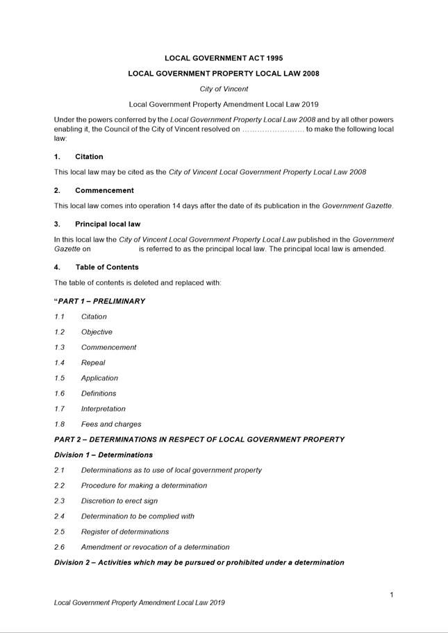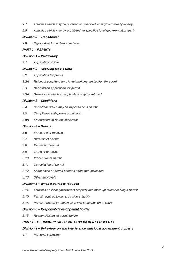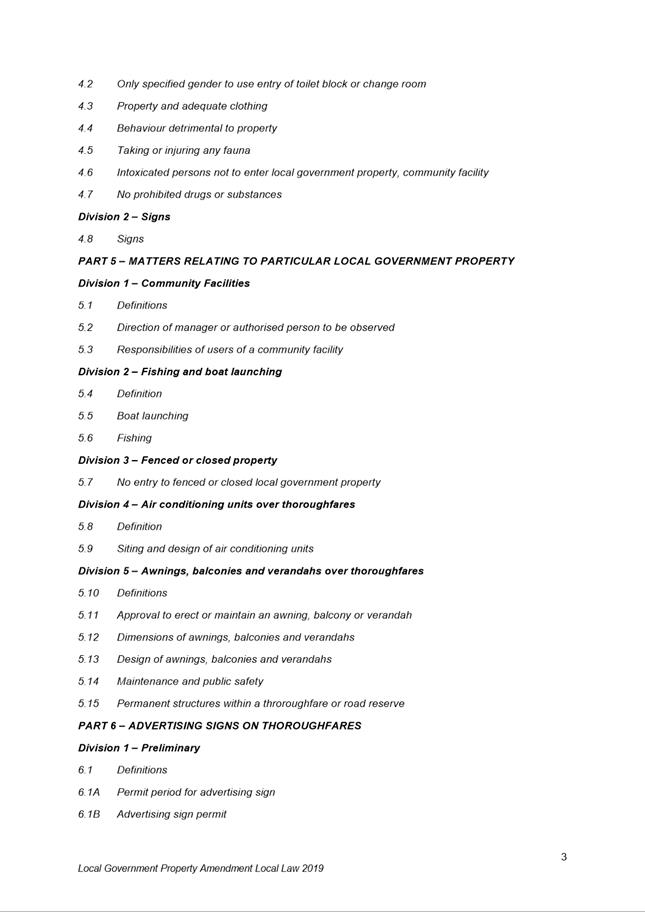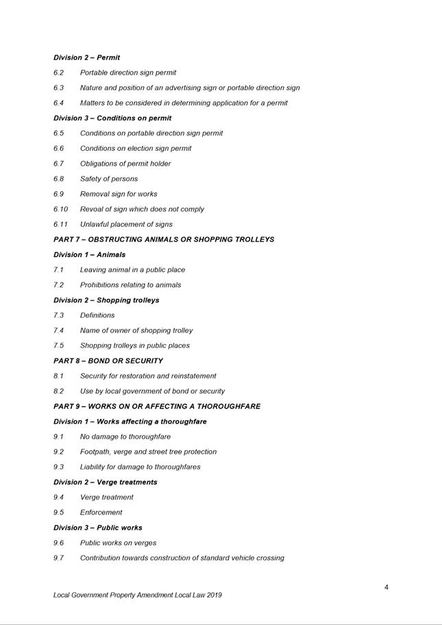
AGENDA
Ordinary Council Meeting
2 April 2019
|
Time: |
6pm |
|
Location: |
Administration and Civic Centre 244 Vincent Street, Leederville |
David MacLennan
Chief Executive Officer
AGENDA
Ordinary Council Meeting
2 April 2019
|
Time: |
6pm |
|
Location: |
Administration and Civic Centre 244 Vincent Street, Leederville |
David MacLennan
Chief Executive Officer
Ordinary Council Meeting Agenda 2 April 2019
DISCLAIMER
No responsibility whatsoever is implied or accepted by the City of Vincent (City) for any act, omission, statement or intimation occurring during Council Briefings or Council Meetings. The City disclaims any liability for any loss however caused arising out of reliance by any person or legal entity on any such act, omission, statement or intimation occurring during Council Briefings or Council Meetings. Any person or legal entity who acts or fails to act in reliance upon any statement, act or omission made in a Council Briefing or Council Meeting does so at their own risk.
In particular and without derogating in any way from the broad disclaimer above, in any discussion regarding any planning or development application or application for a licence, any statement or intimation of approval made by an Elected Member or Employee of the City during the course of any meeting is not intended to be and is not to be taken as notice of approval from the City. The City advises that anyone who has any application lodged with the City must obtain and should only rely on WRITTEN CONFIRMATION of the outcome of the application, and any conditions attaching to the decision made by the Council in respect of the application.
Copyright
Any plans or documents contained within this Agenda may be subject to copyright law provisions (Copyright Act 1968, as amended) and that the express permission of the copyright owner(s) should be sought prior to their reproduction. It should be noted that Copyright owners are entitled to take legal action against any persons who infringe their copyright. A reproduction of material that is protected by copyright may represent a copyright infringement.
PROCEDURE FOR PUBLIC SPEAKING TIME
The City of Vincent Local Law Relating to Meeting Procedures prescribes the procedure for persons to ask questions or make public statements relating to a matter affecting the City, either verbally or in writing, at a Council meeting.
Questions or statements made at an Ordinary Council meeting can relate to matters that affect the City. Questions or statements made at a Special Meeting of the Council must only relate to the purpose for which the meeting has been called.
1. Shortly after the commencement of the meeting, the Presiding Member will ask members of the public to come forward to address the Council and to give their name and the suburb in which they reside or, where a member of the public is representing the interests of a business, the suburb in which that business is located and Agenda Item number (if known).
2. Public speaking time will be strictly limited to three (3) minutes per member of the public.
3. Members of the public are encouraged to keep their questions/statements brief to enable everyone who desires to ask a question or make a statement to have the opportunity to do so.
4. Public speaking time is declared closed when there are no further members of the public who wish to speak.
5. Questions/statements are to be directed to the Presiding Member and are to be made politely in good faith and are not to be framed in such a way as to reflect adversely or be defamatory on a Council Member or City Employee.
6. Where the Presiding Member is of the opinion that a member of the public is making a statement at a Council meeting, that does not affect the City, he may ask the person speaking to promptly cease.
7. Questions/statements and any responses will be summarised and included in the Minutes of the Council meeting.
8. Where practicable, responses to questions will be provided at the meeting. Where the information is not available or the question cannot be answered, it will be “taken on notice” and a written response will be sent by the Chief Executive Officer to the person asking the question. A copy of the reply will be included in the Agenda of the next Ordinary meeting of the Council.
9. It is not intended that public speaking time should be used as a means to obtain information that would not be made available if it was sought from the City’s records under Section 5.94 of the Local Government Act 1995 or the Freedom of Information (FOI) Act 1992. The CEO will advise the member of the public that the information may be sought in accordance with the FOI Act 1992.
RECORDING AND WEBSTREAMING OF COUNCIL MEETINGS
· All Ordinary and Special Council Meetings are electronically recorded except when the Council resolves to go behind closed doors;
· All recordings are retained as part of the City's records in accordance with the General Disposal Authority for Local Government Records produced by the Public Records Office;
· A copy of the recorded proceedings and/or a transcript of a particular section or all of a Council meeting is available in accordance with Policy No. 4.2.4 – Council Meetings – Recording and Web Streaming.
· Ordinary Meetings of Council and Council Briefings are streamed live on the internet in accordance with the City’s Policy – 4.2.4 - Council Meetings Recording and Web Streaming. It is another way the City is striving for transparency and accountability in what we do.
· The live stream can be accessed from http://webcast.vincent.wa.gov.au/video.php
· Images of the public gallery are not included in the webcast, however the voices of people in attendance may be captured and streamed.
· If you have any issues or concerns with the live streaming of meetings, please contact the City’s Manager Governance and Risk on 08 9273 6538.
Ordinary Council Meeting Agenda 2 April 2019
1 Declaration of Opening / Acknowledgement of Country
2 Apologies / Members on Leave of Absence
3 (A) Public Question Time and Receiving of Public Statements
(B) Response to Previous Public Questions Taken On Notice
4 Applications for Leave of Absence
5 The Receiving of Petitions, Deputations and Presentations
7 Announcements by the Presiding Member (Without Discussion)
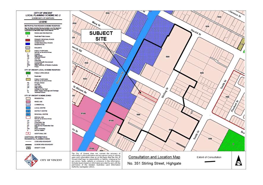
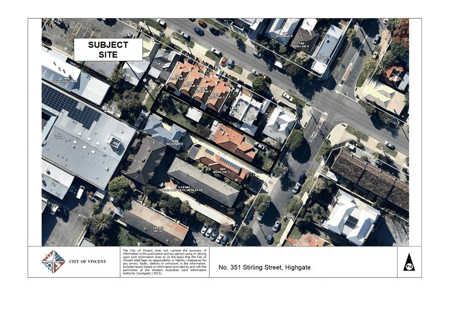
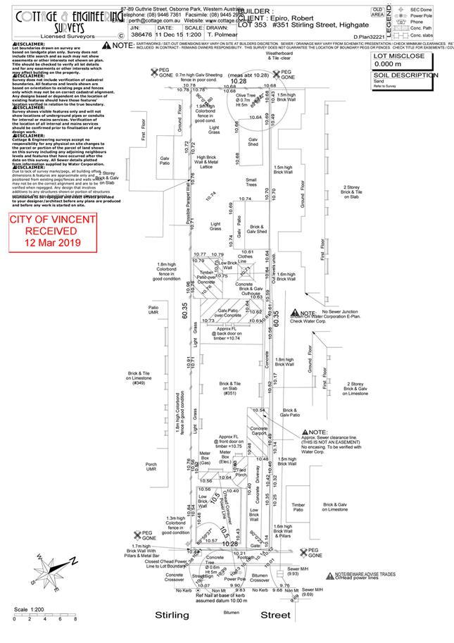
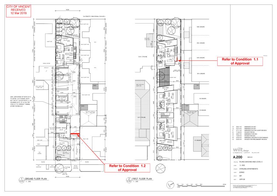
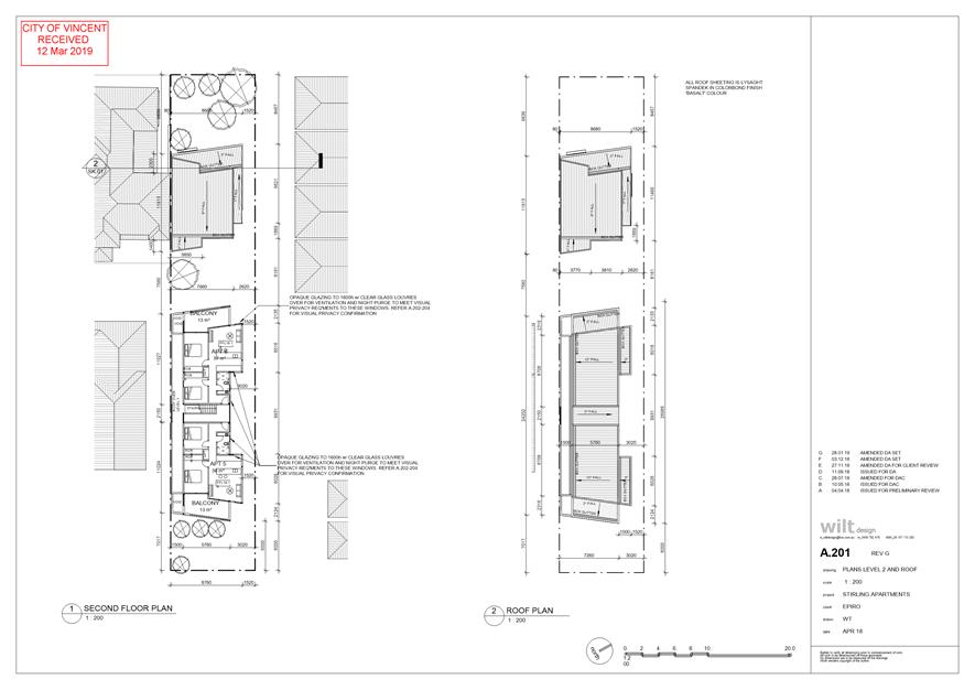
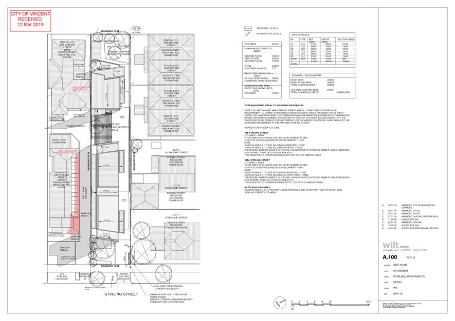
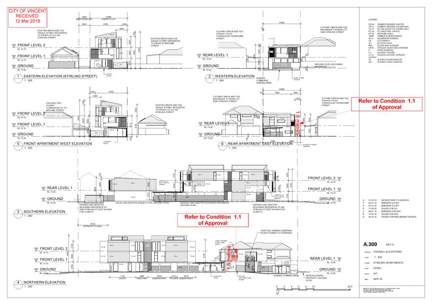
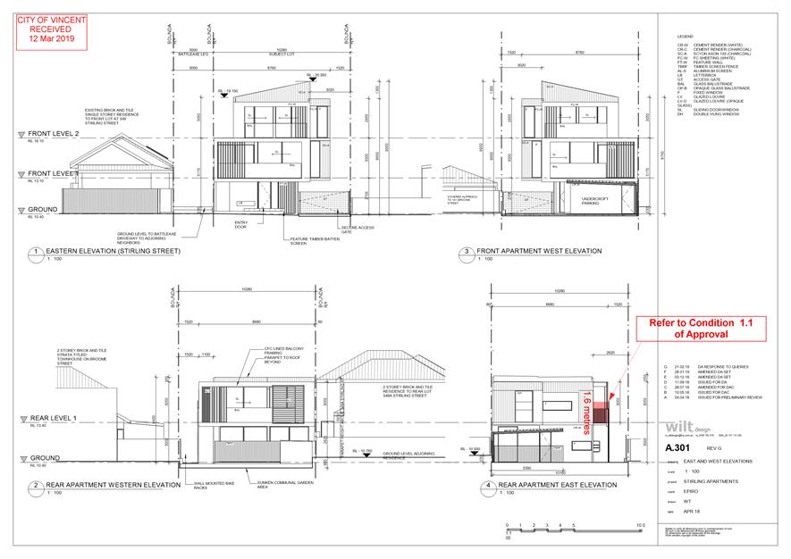
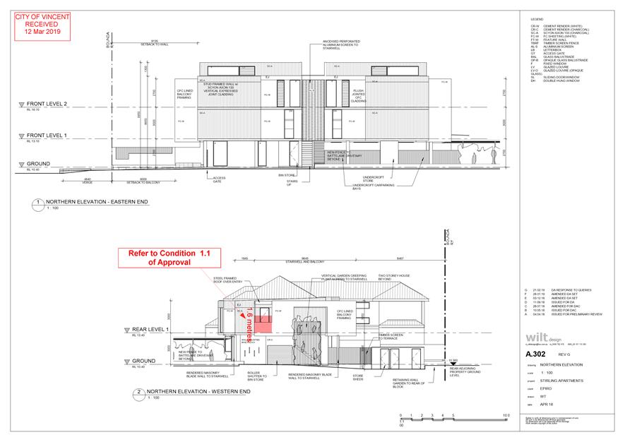
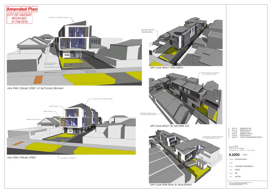
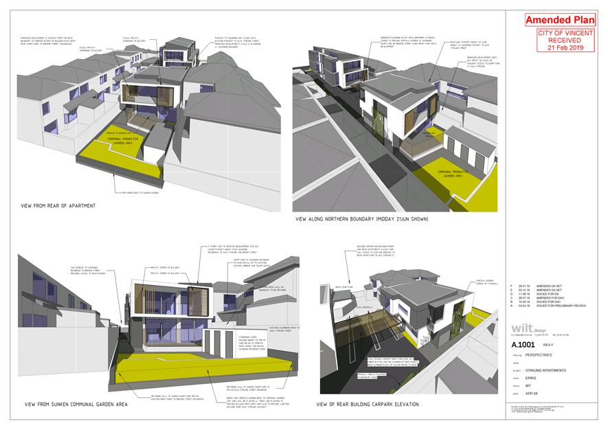
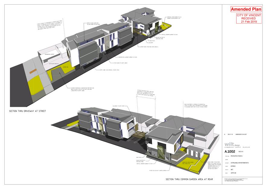
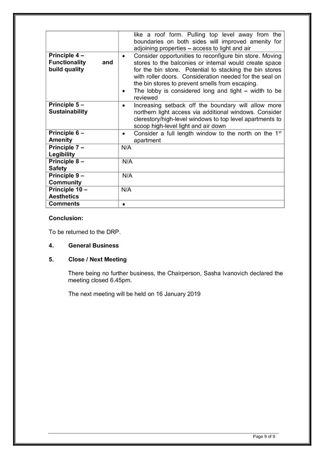
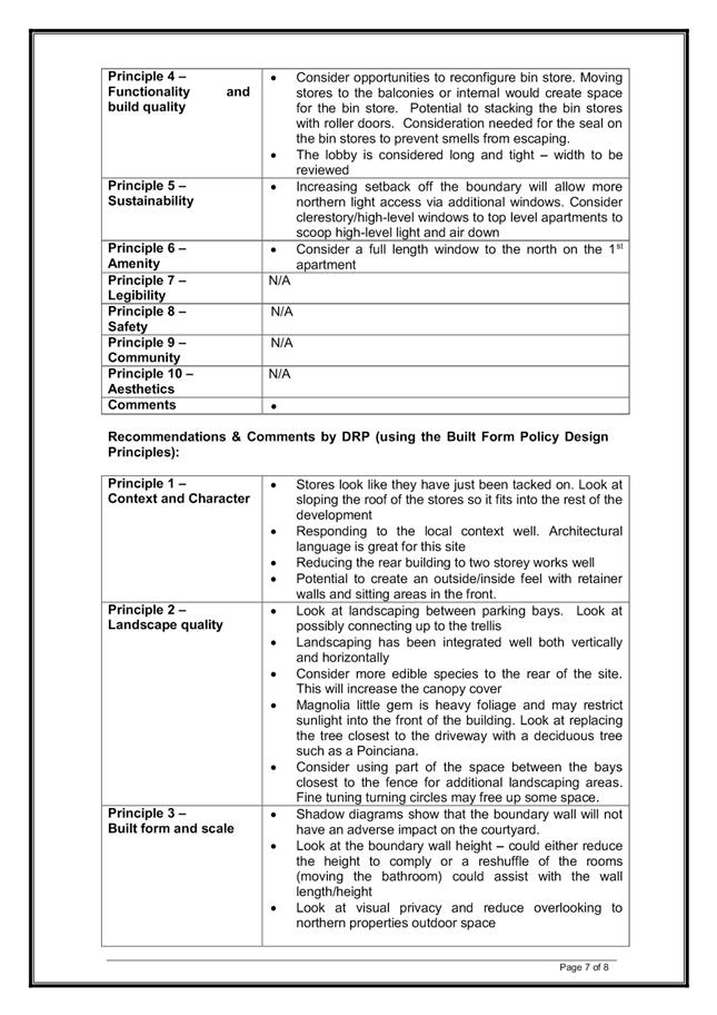
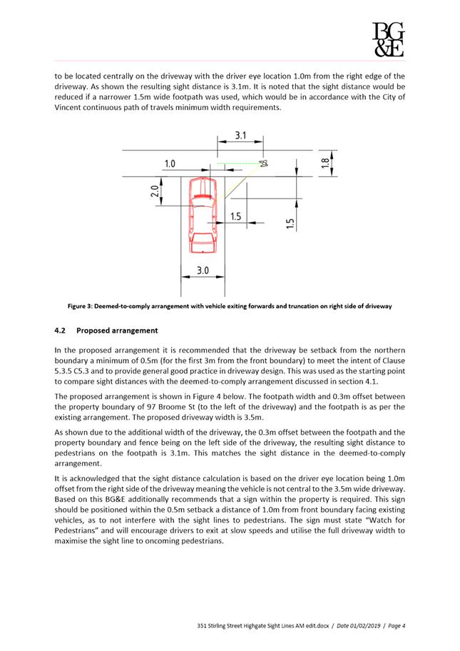
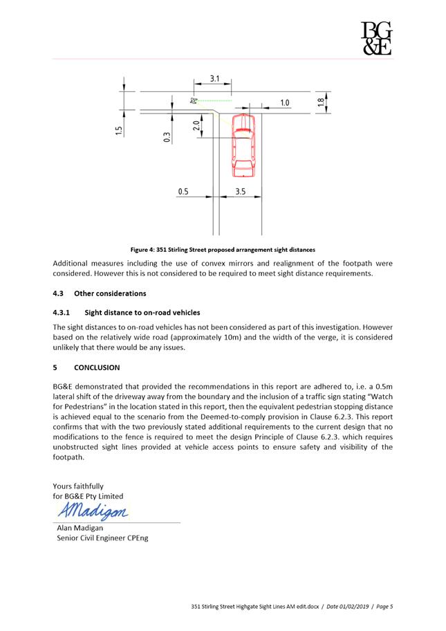
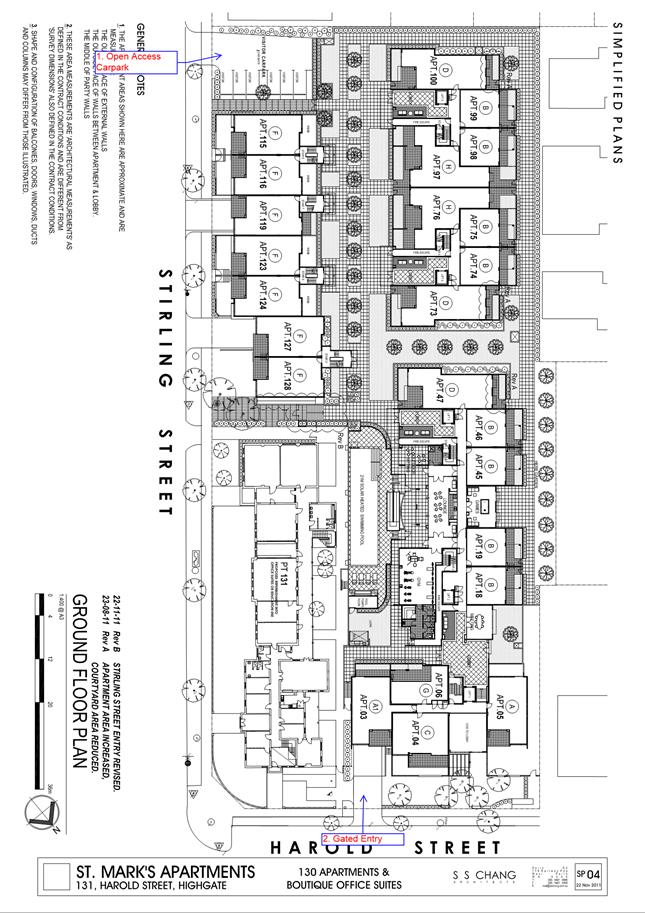
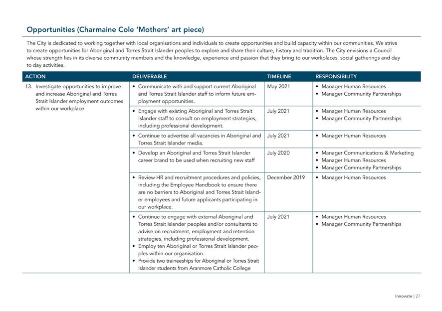
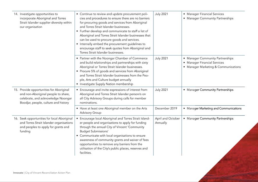
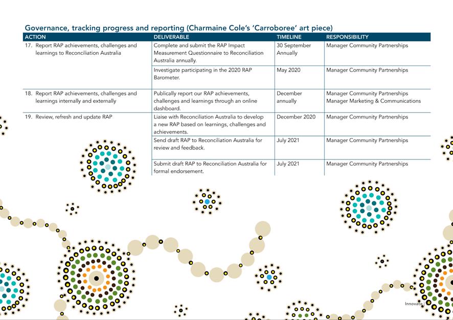
9.5 No. 351 (Lot: 353, D/P: 32221) Stirling Street, Highgate - Six Multiple Dwellings
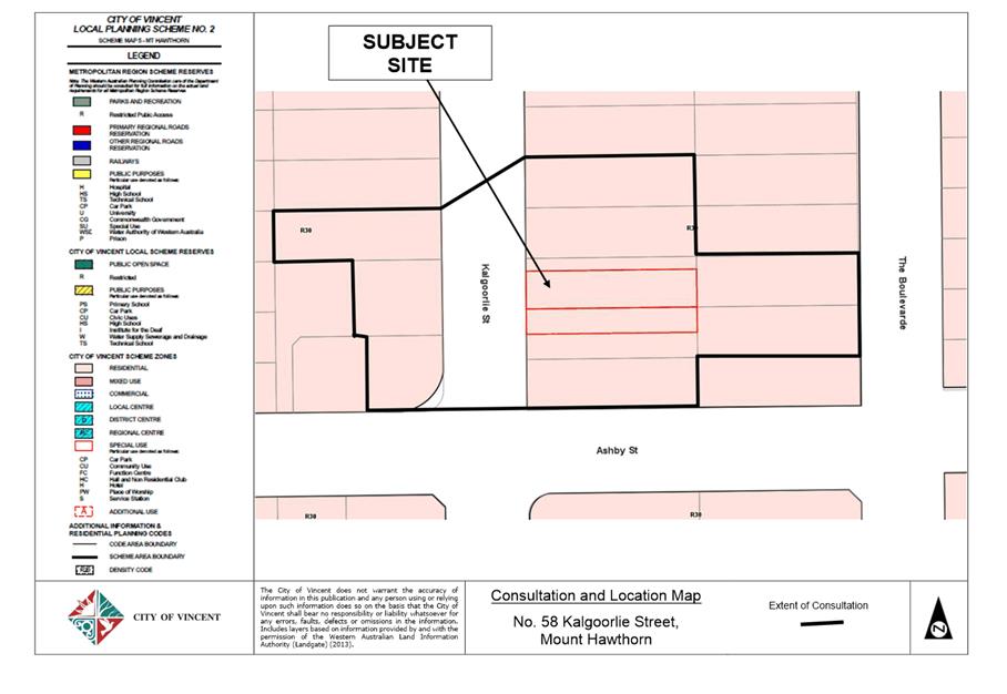
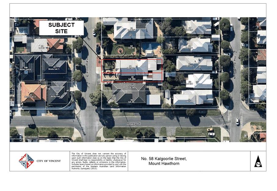
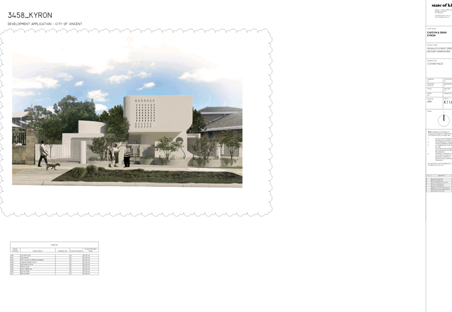
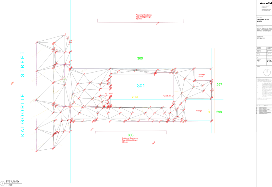
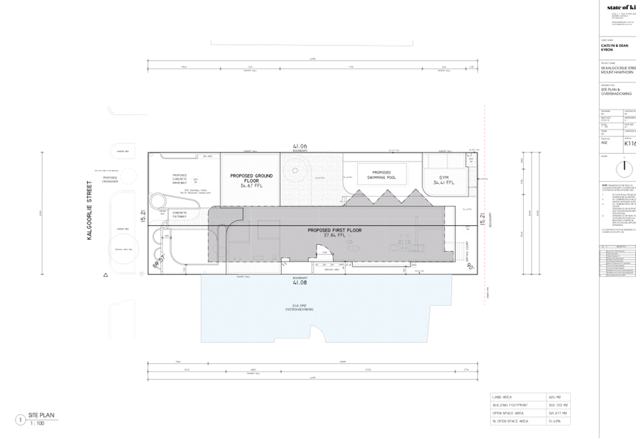
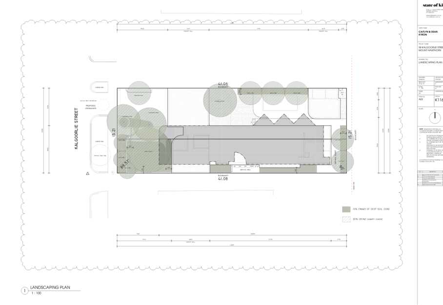
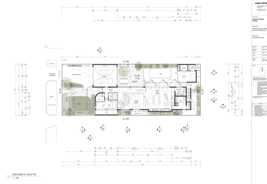
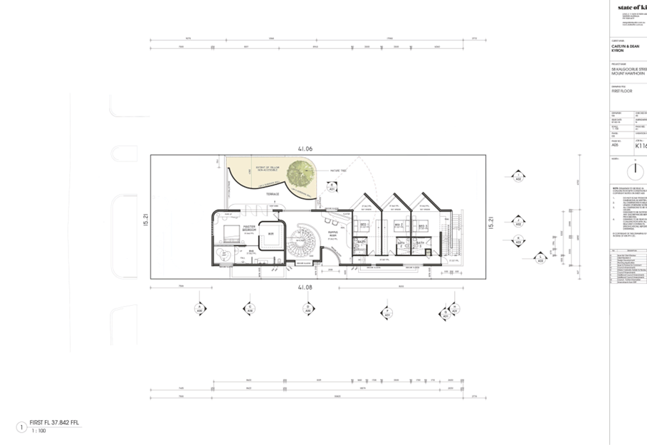
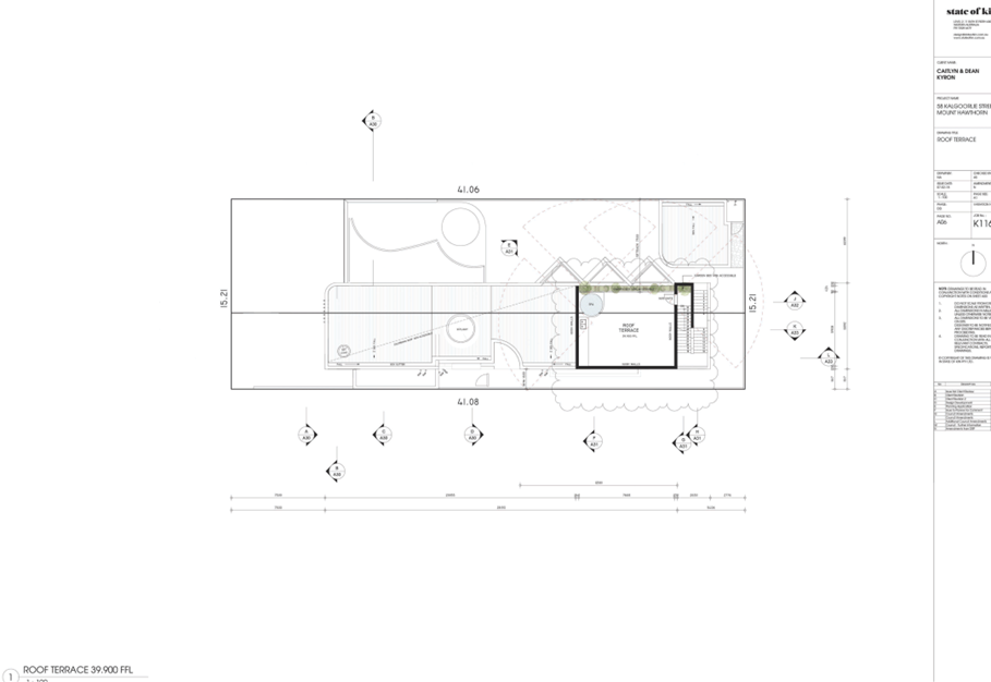
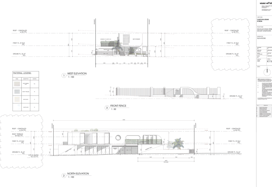
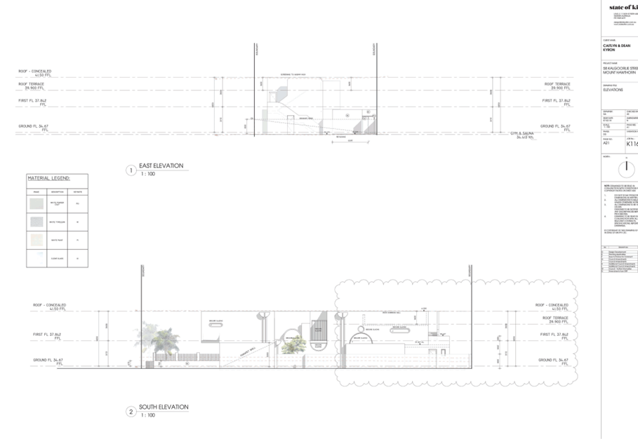
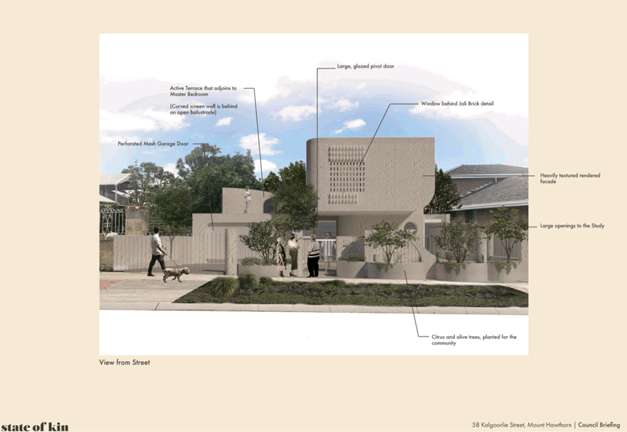
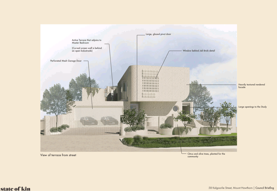
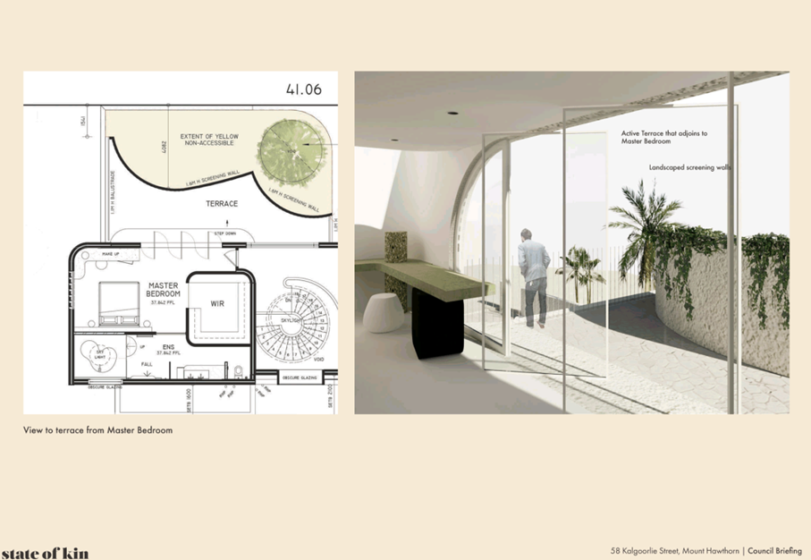
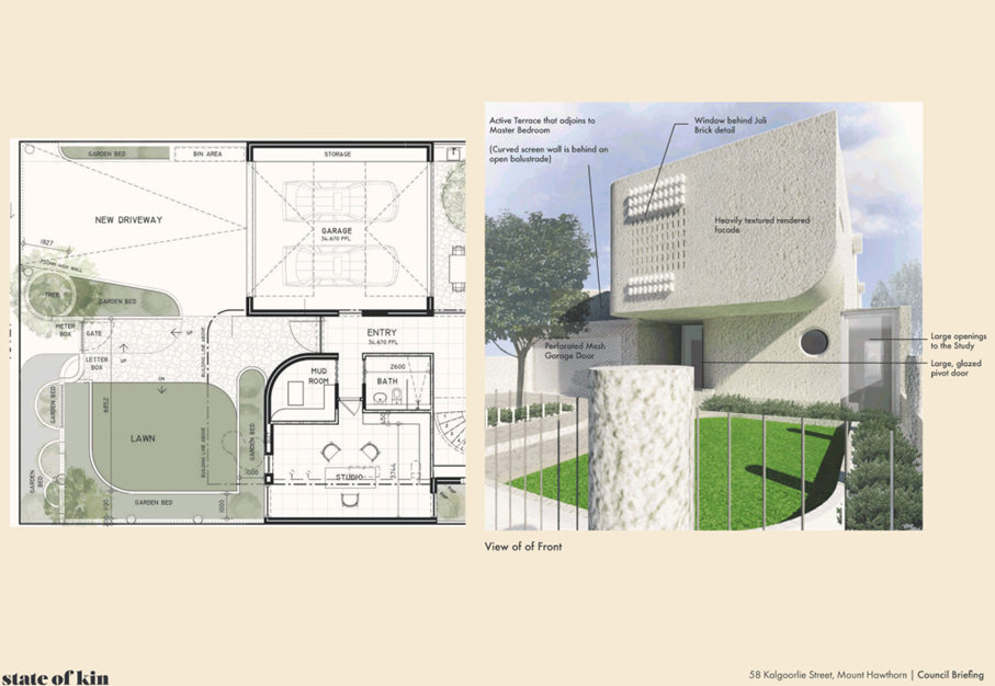
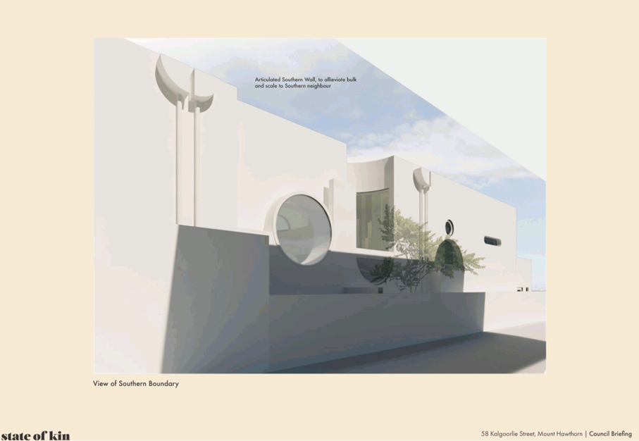
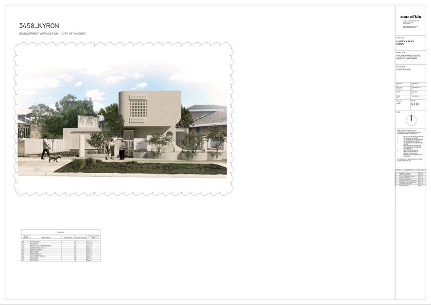
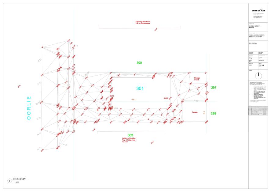
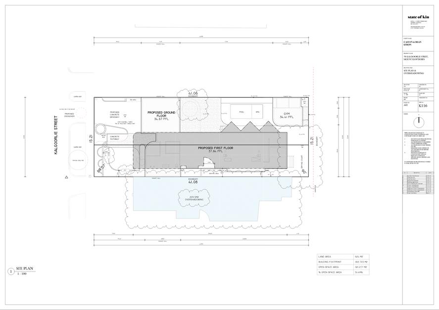
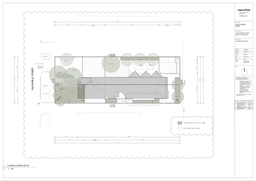
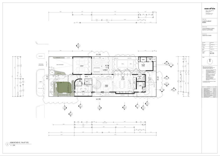
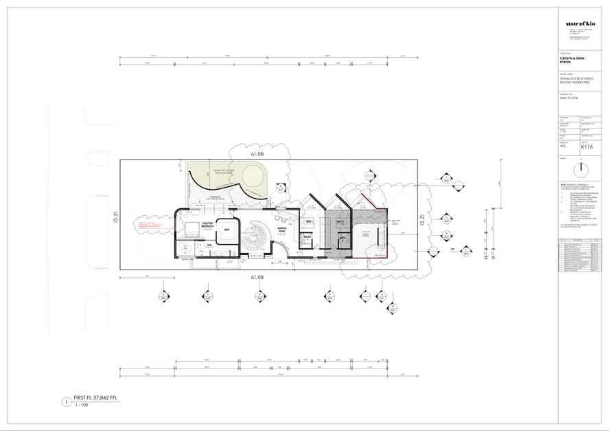
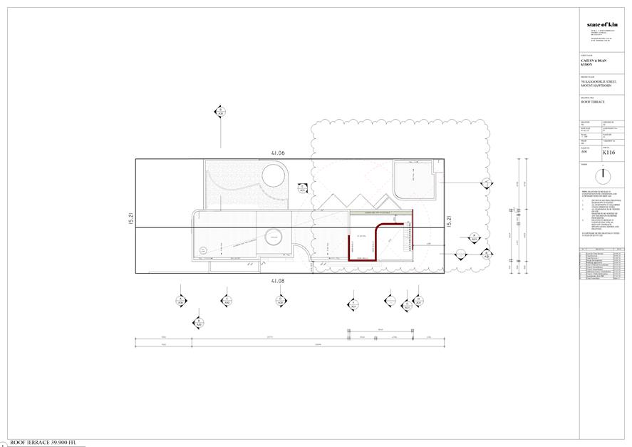
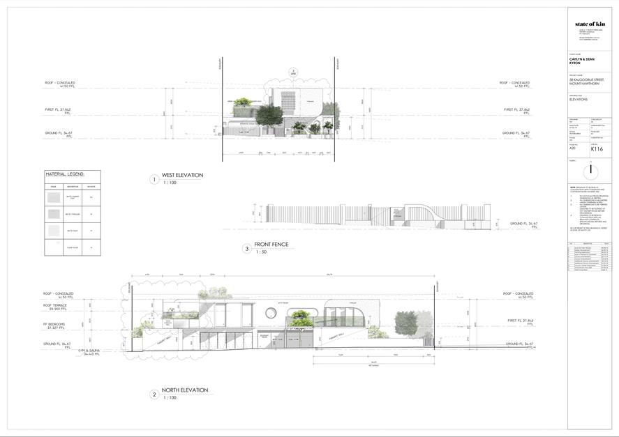
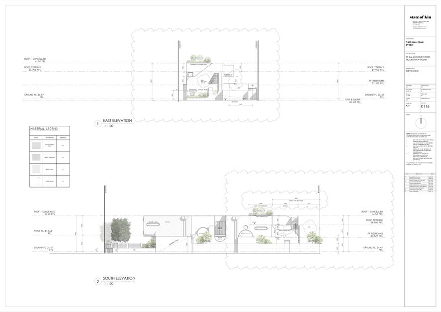
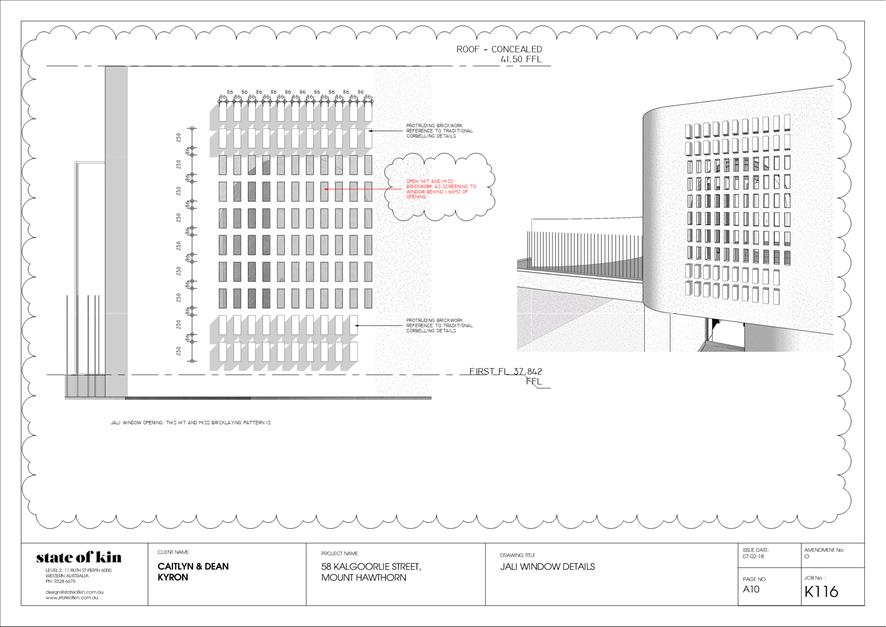
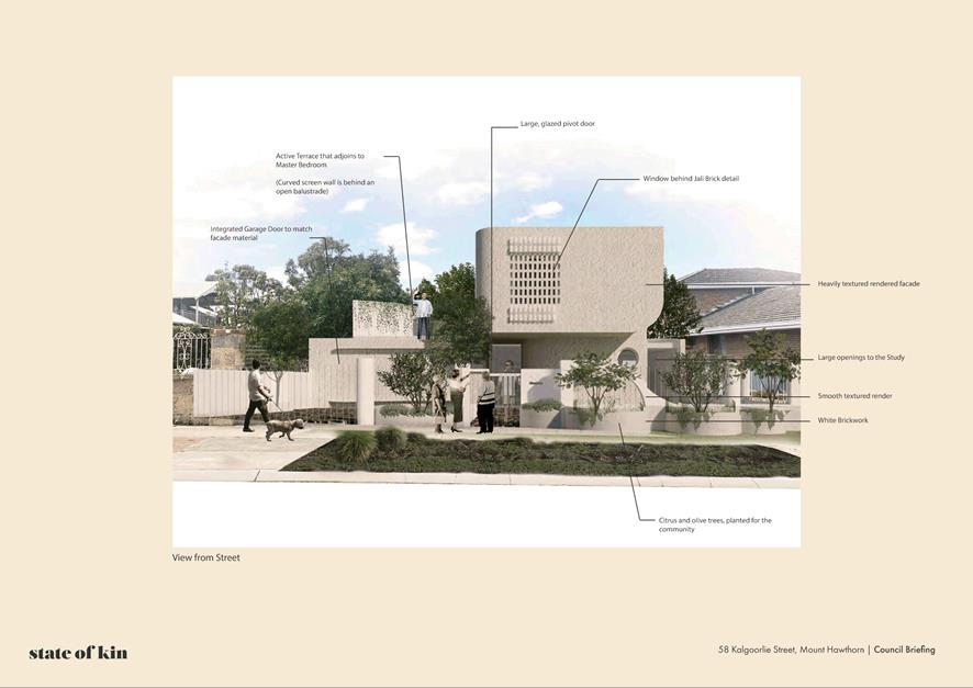
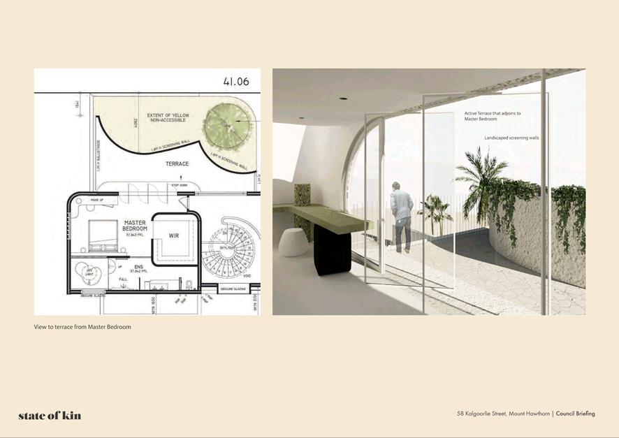
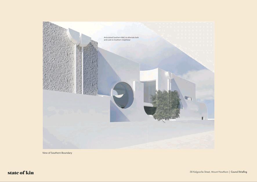
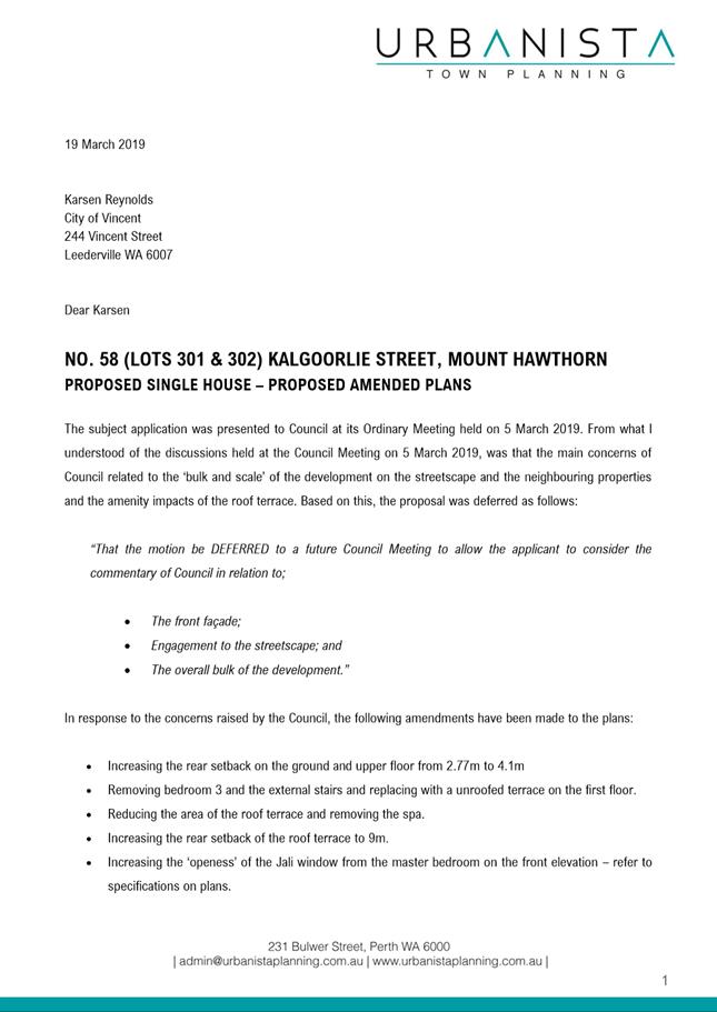
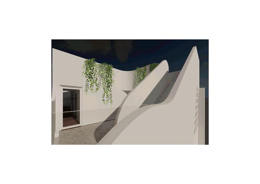
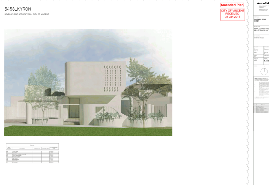
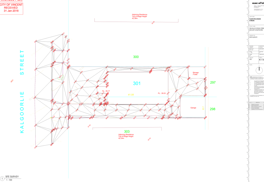
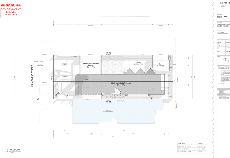
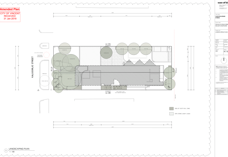
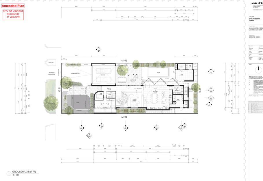
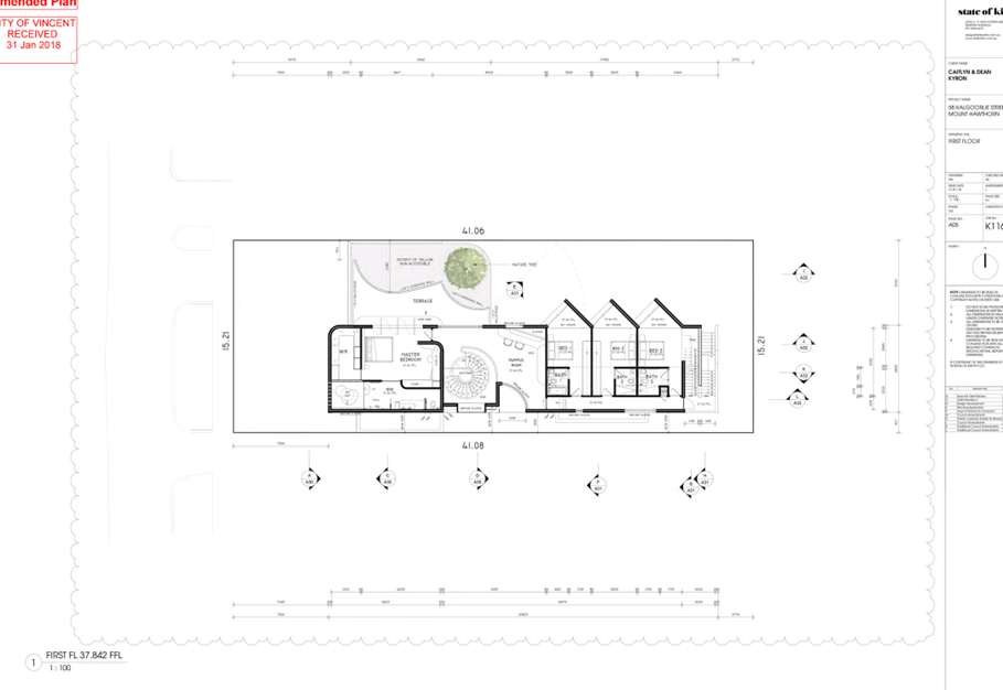
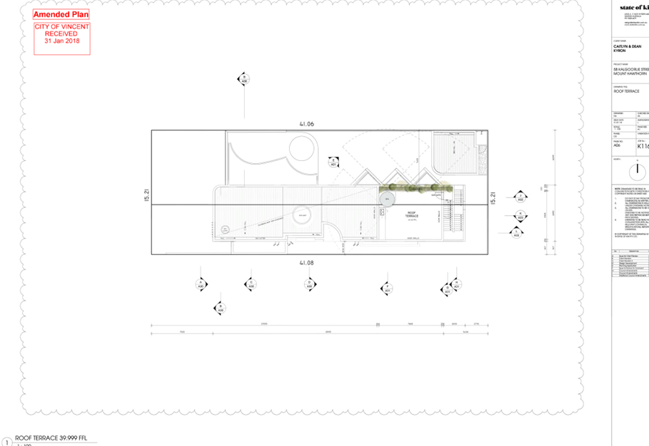
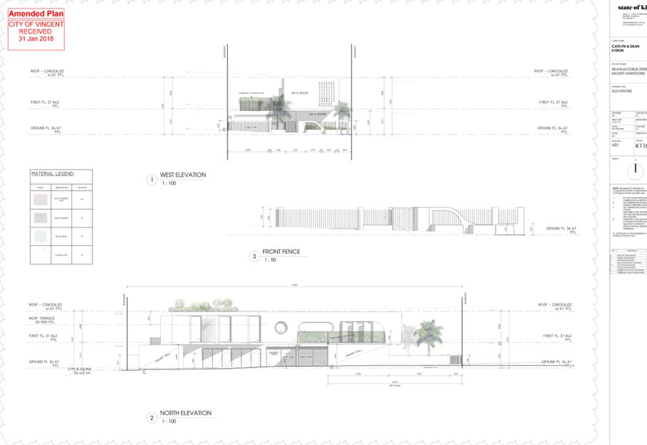
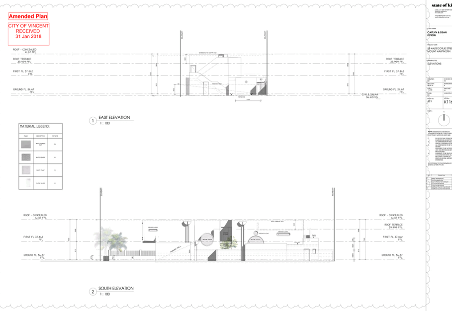
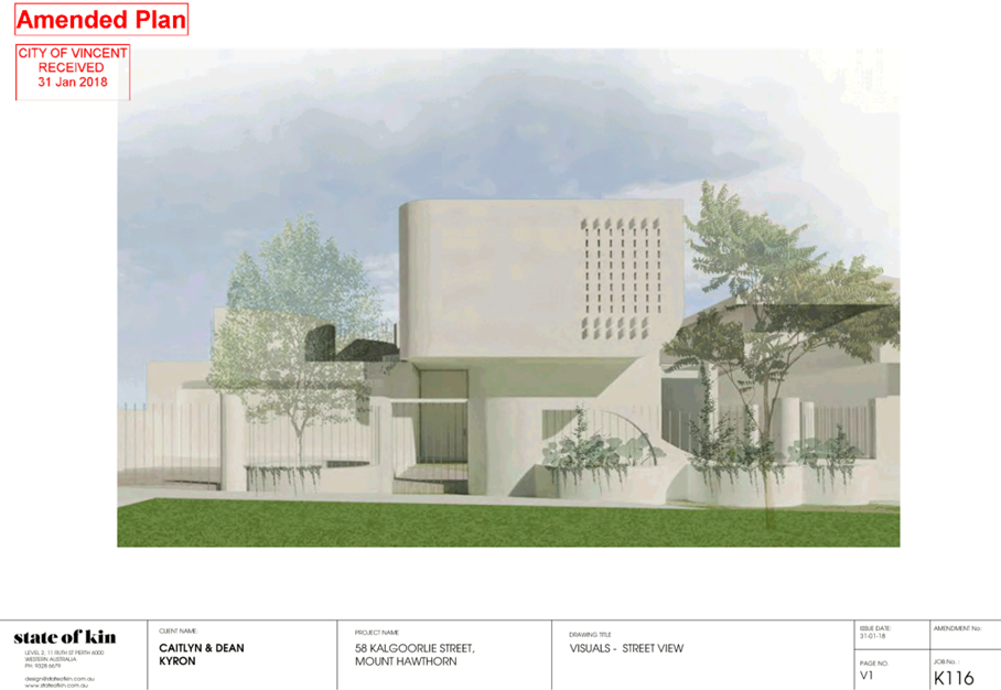
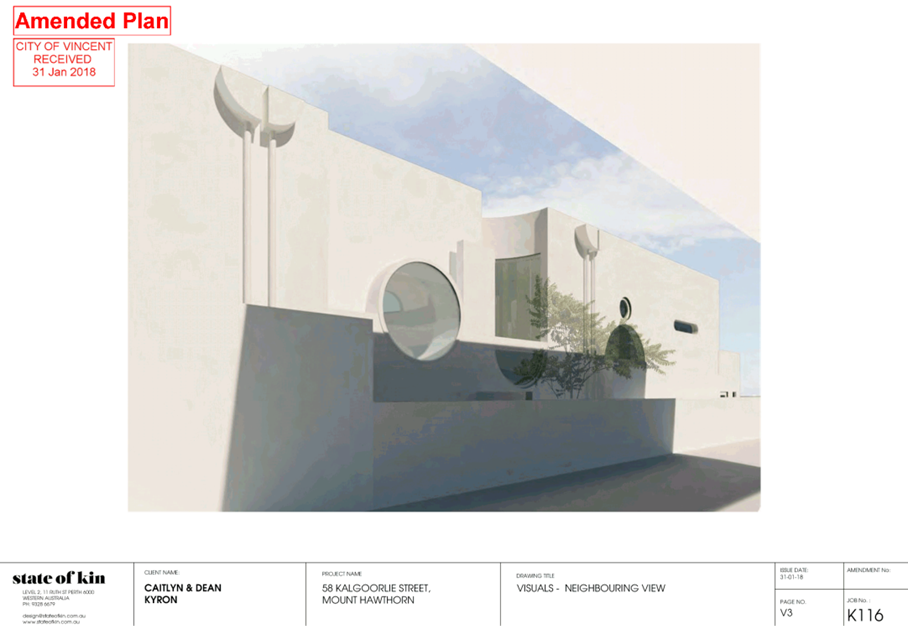
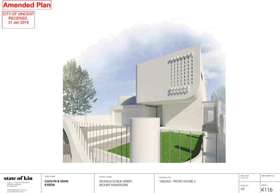
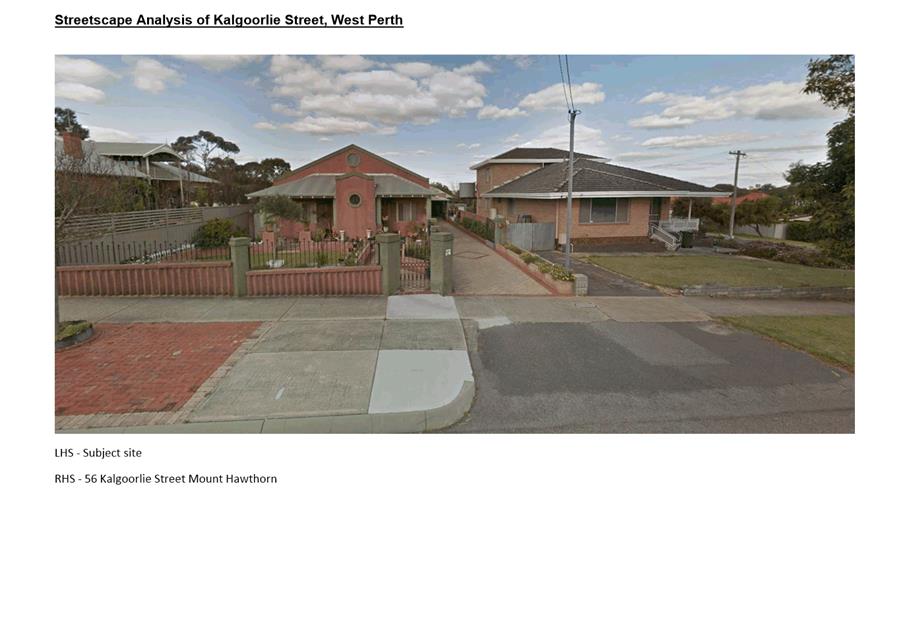
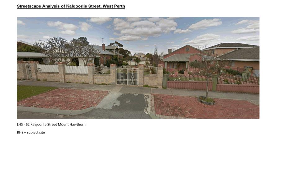
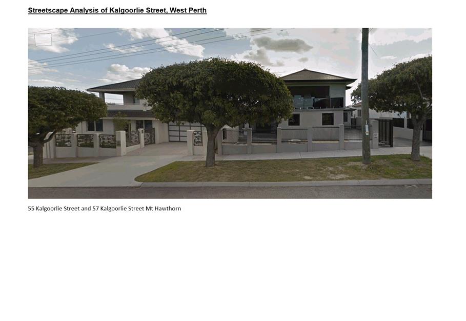
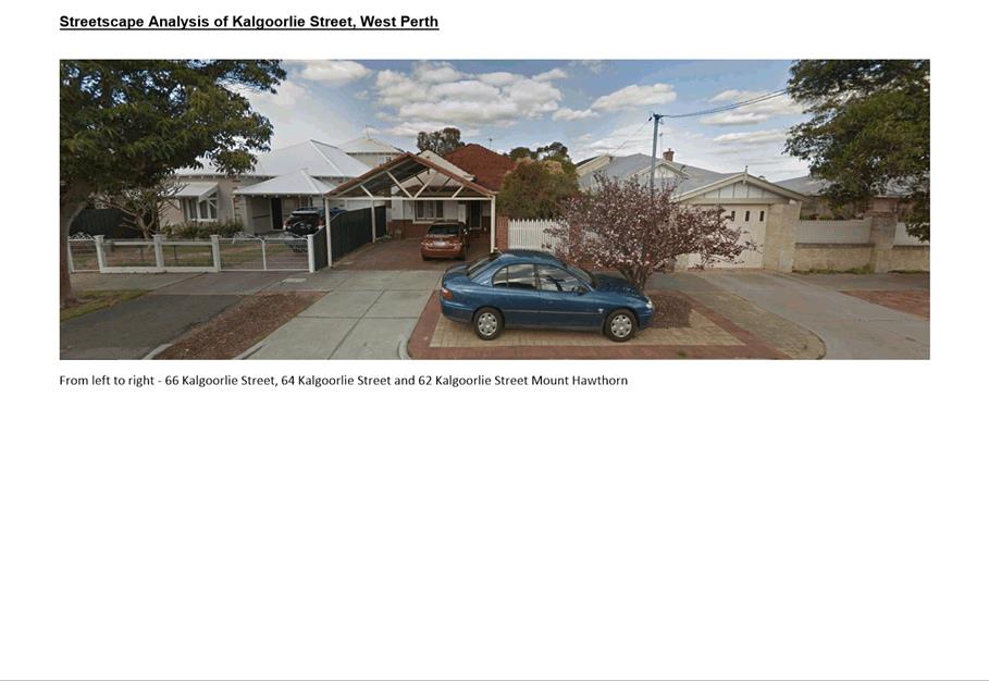
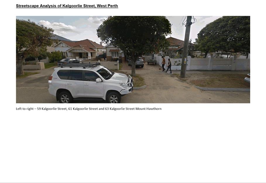
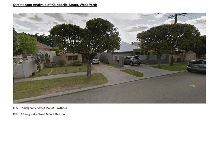
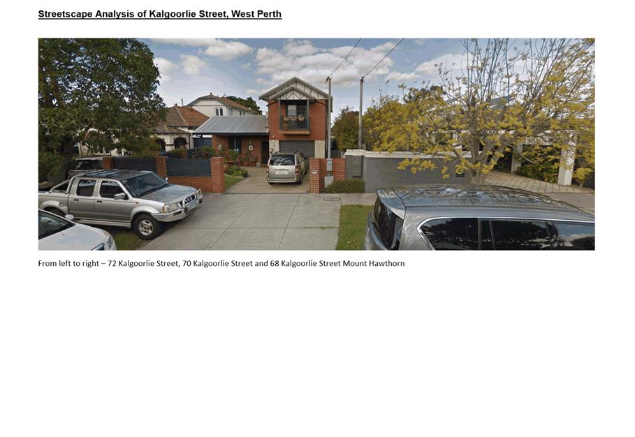
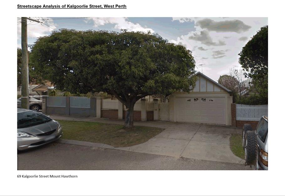
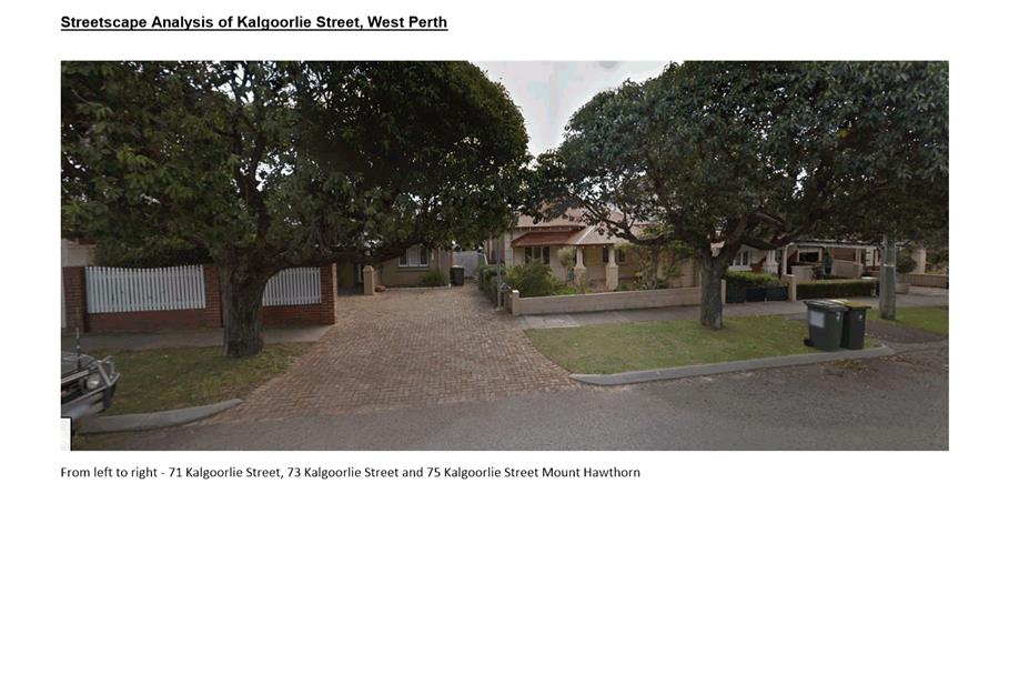
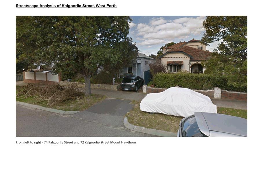
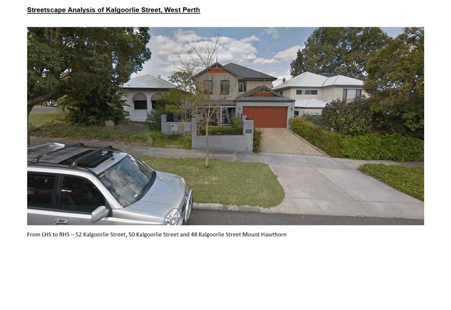
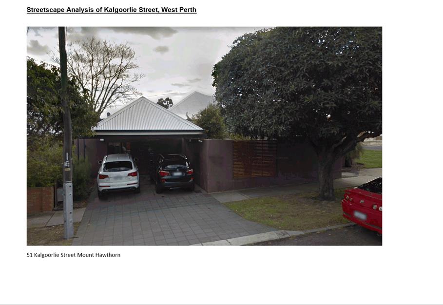
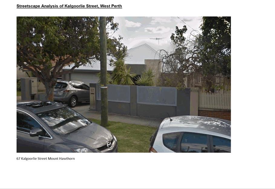
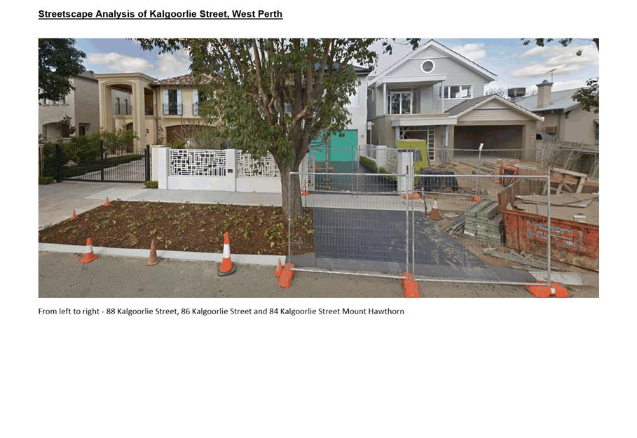
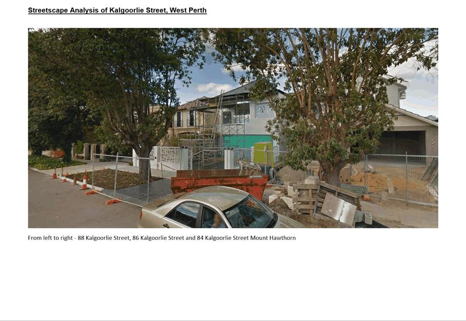
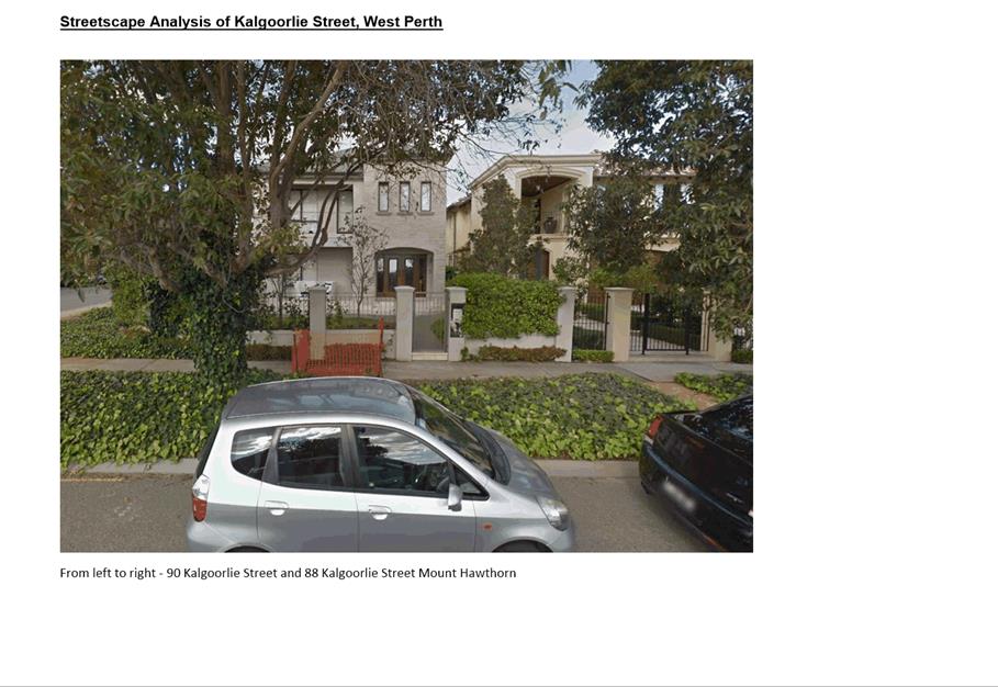
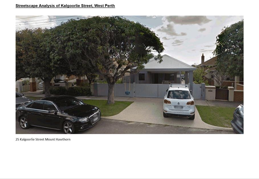
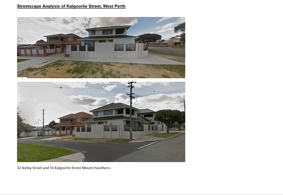
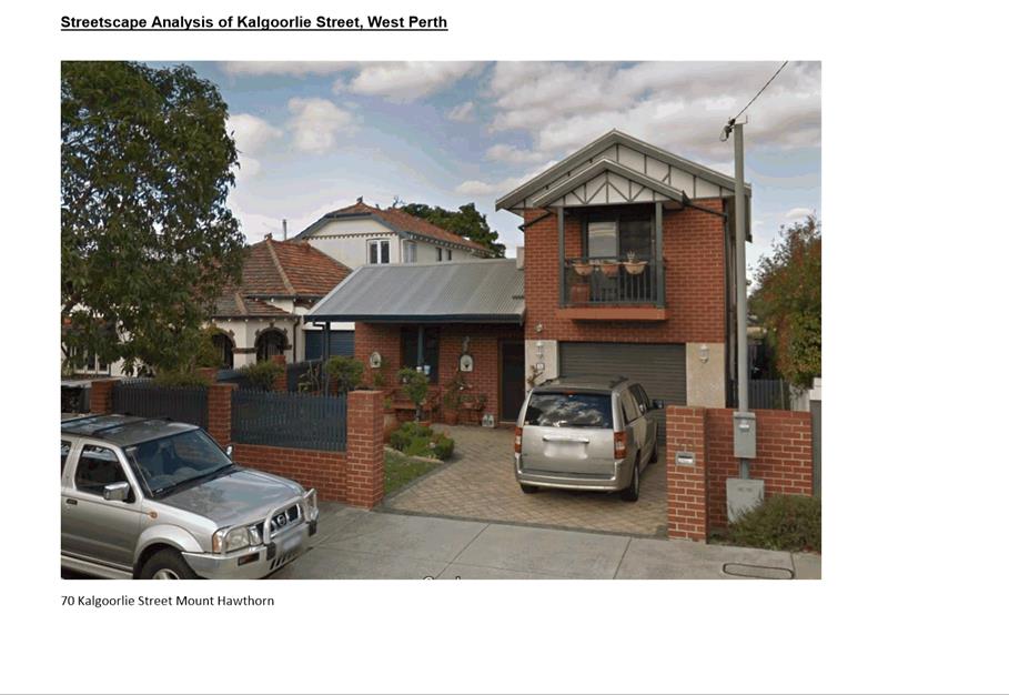
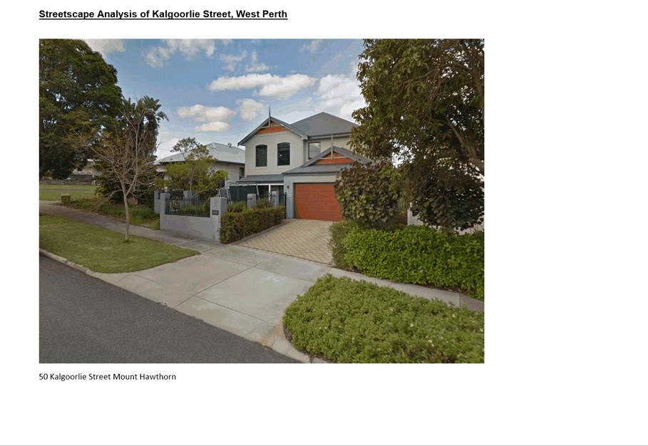
9.8 No. 58 (Lot: 301 & 302; D/P: 34680) Kalgoorlie Street, Mount Hawthorn - Single House
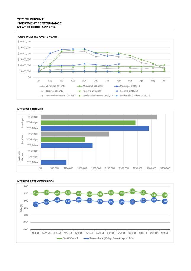
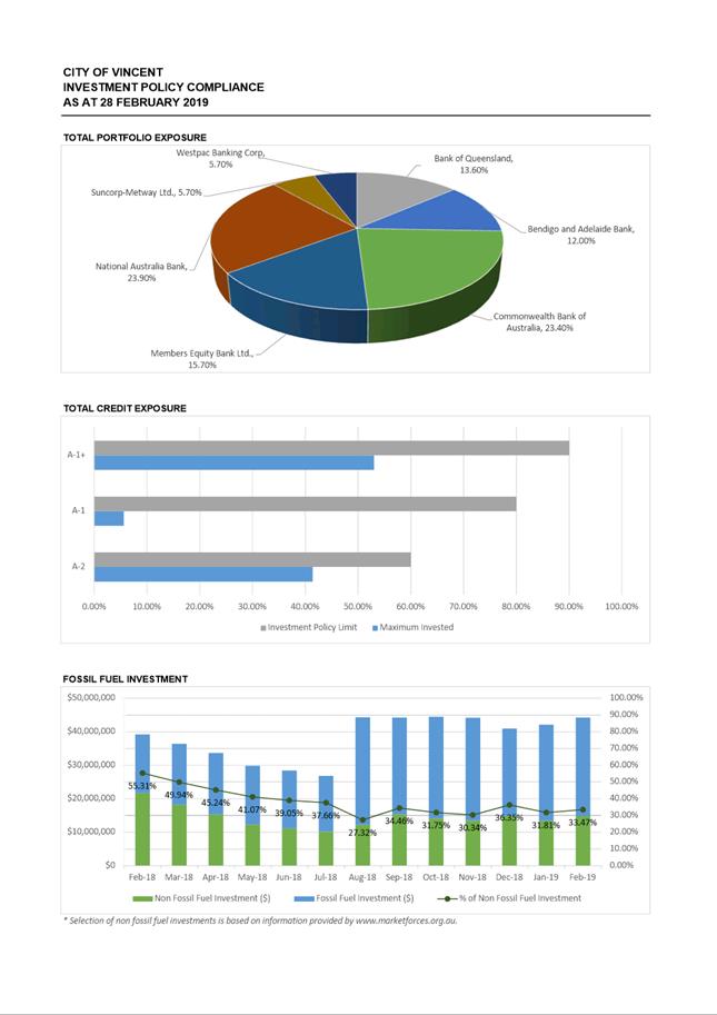
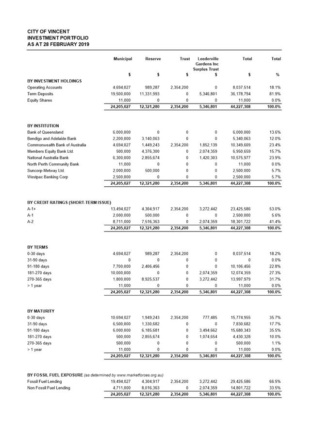
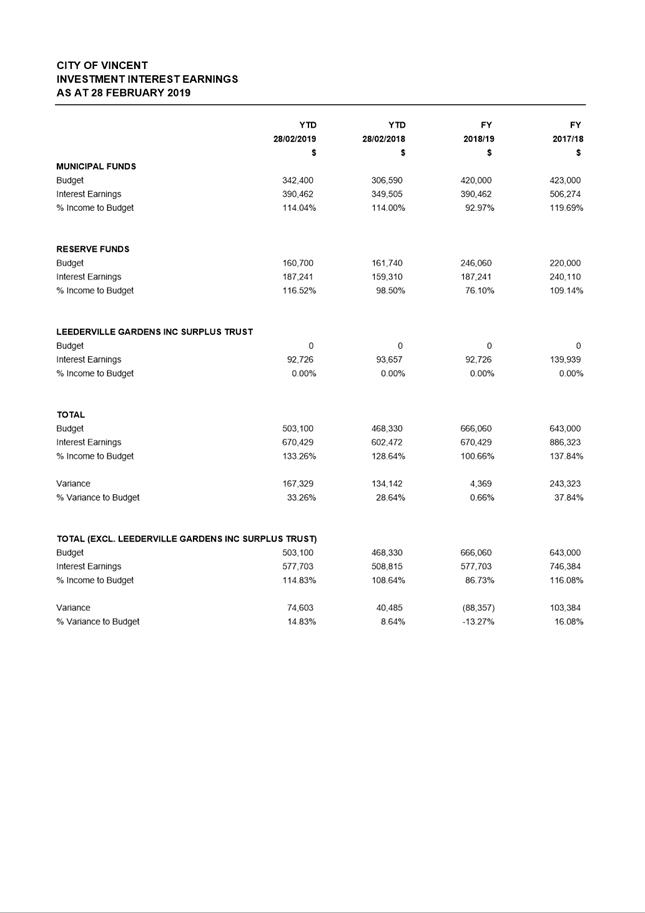
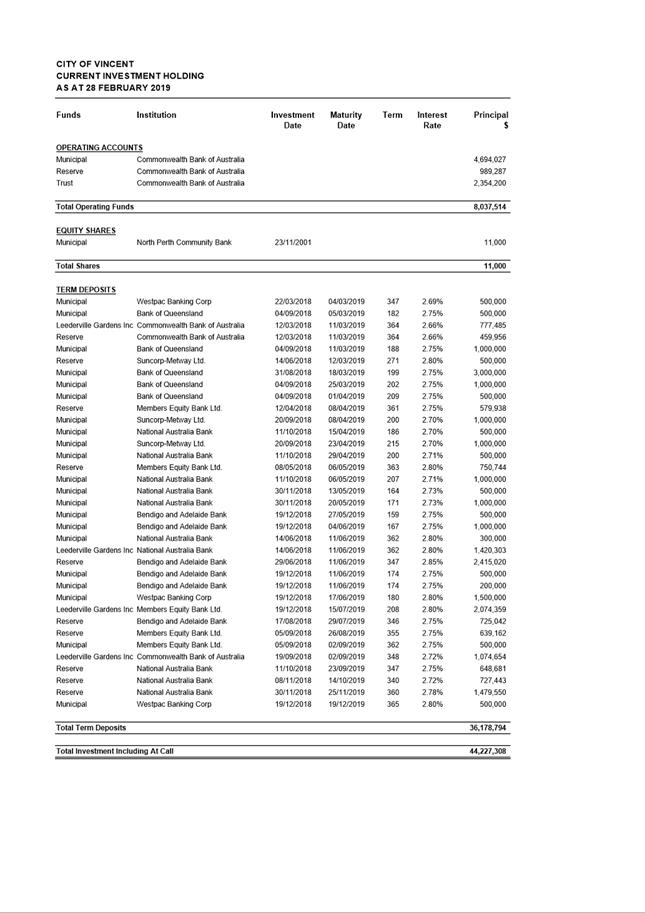
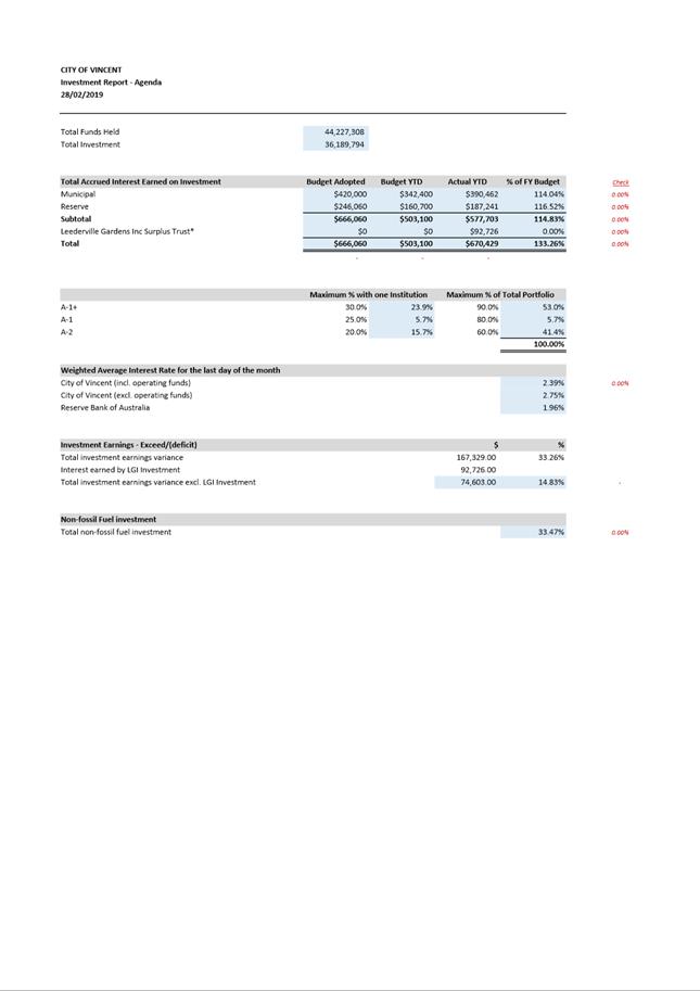
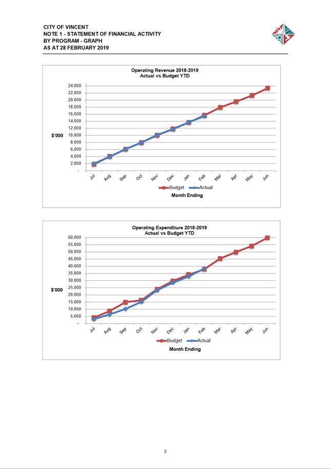
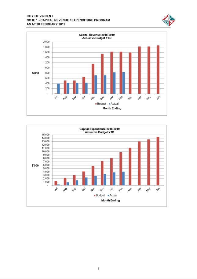
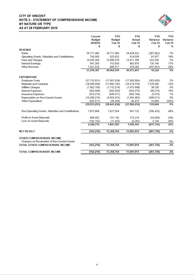
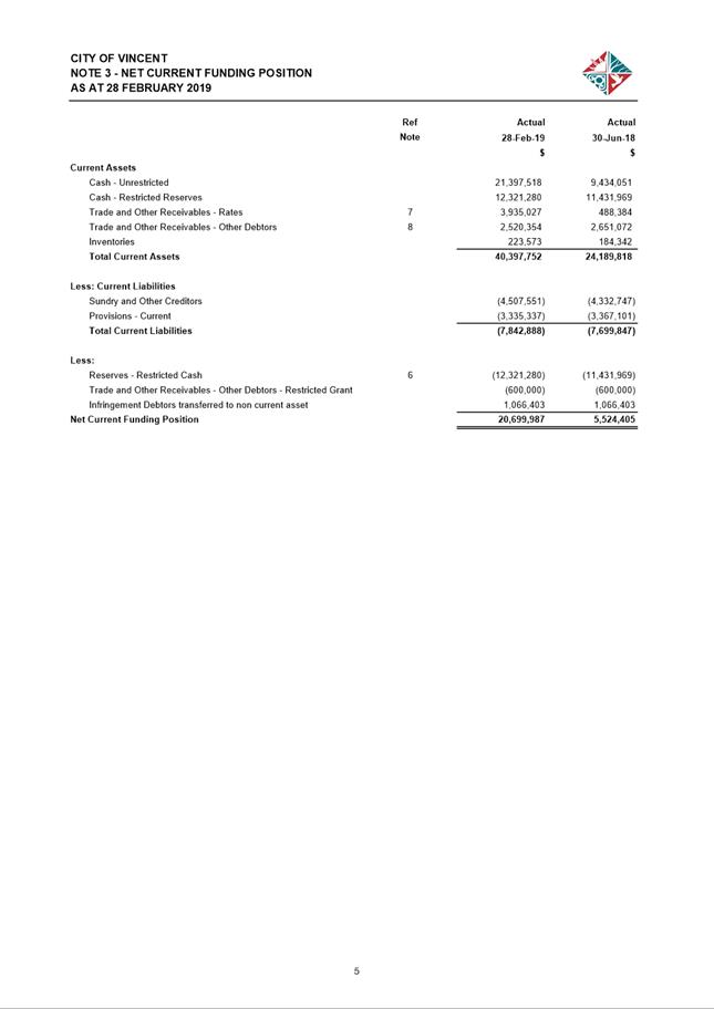
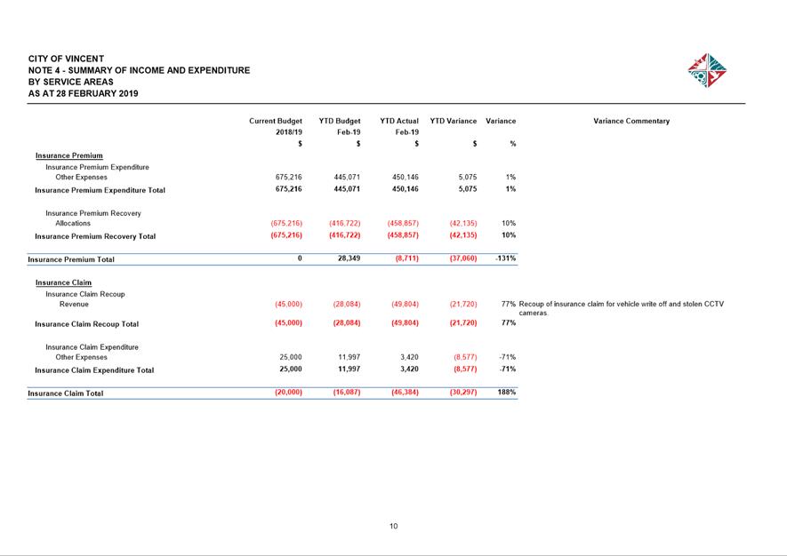
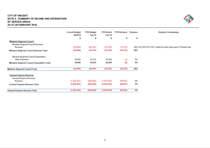
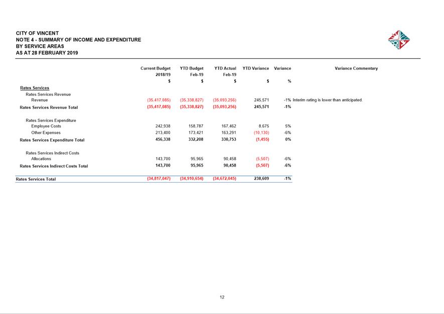
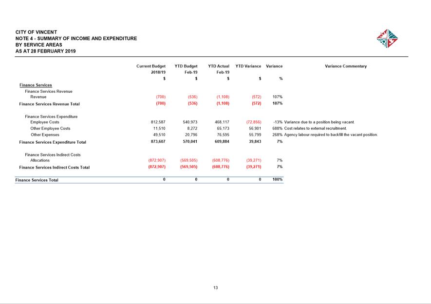
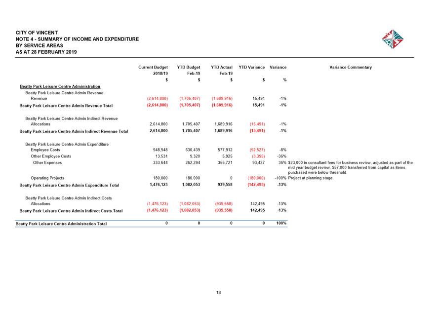
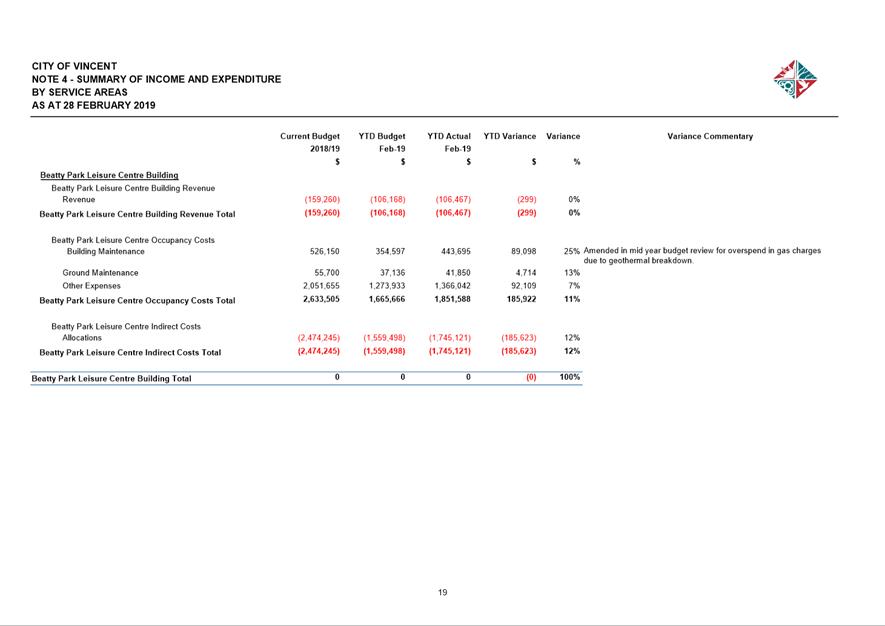
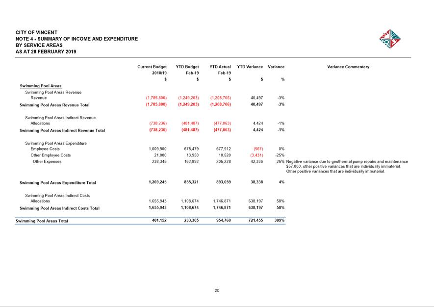
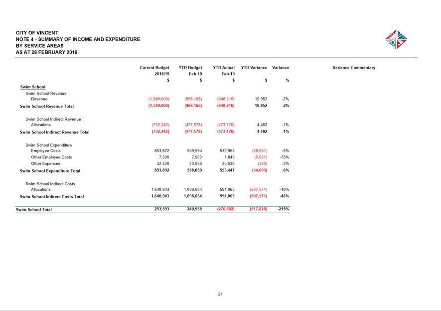
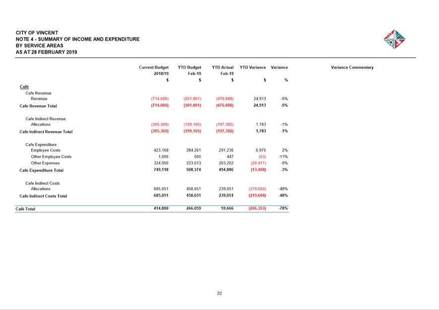
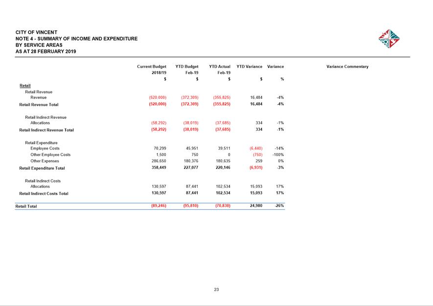
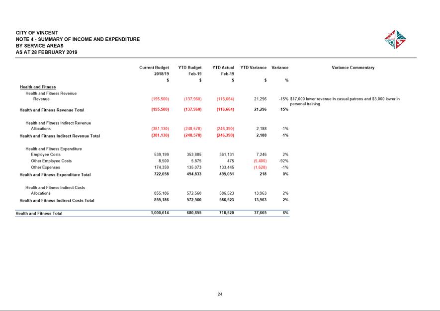
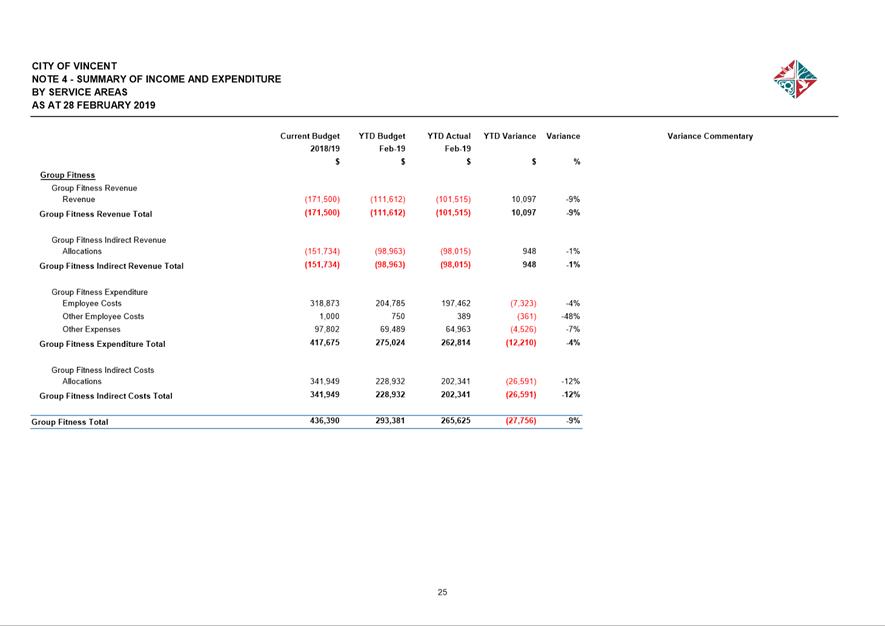
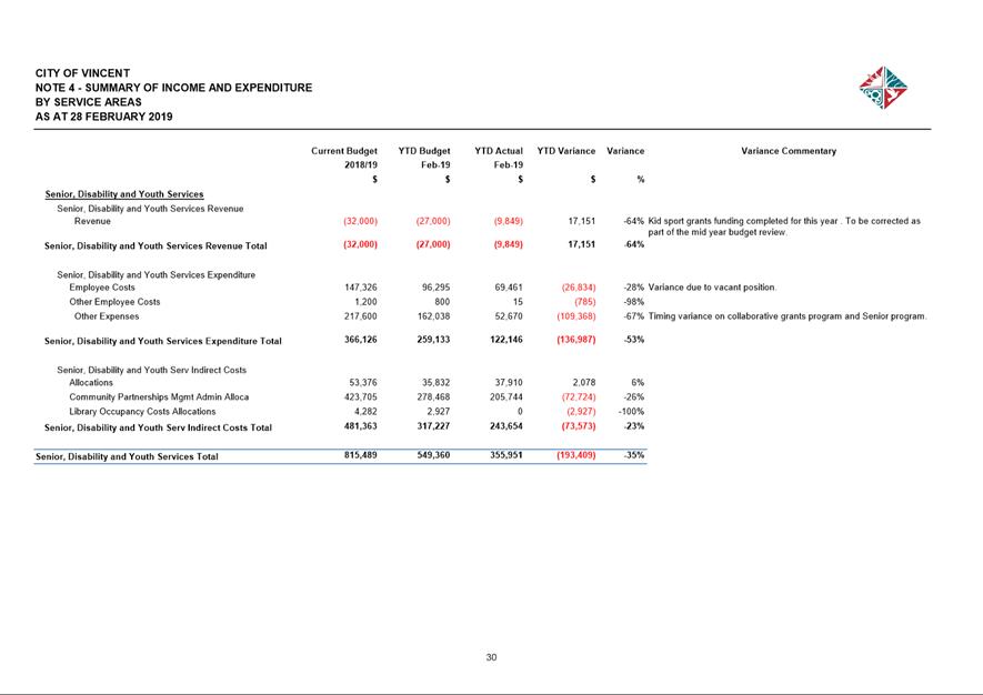
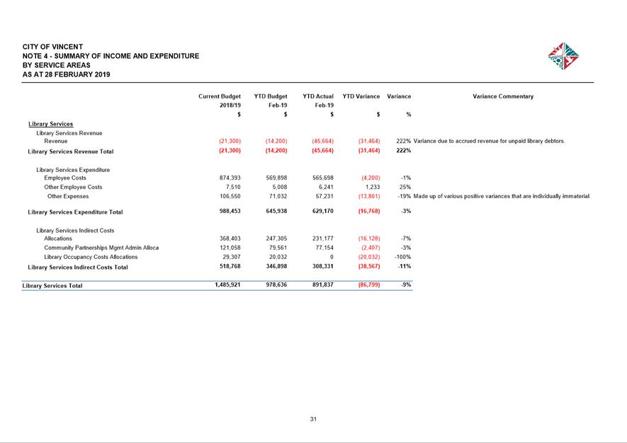
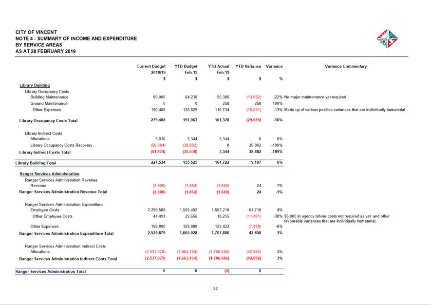
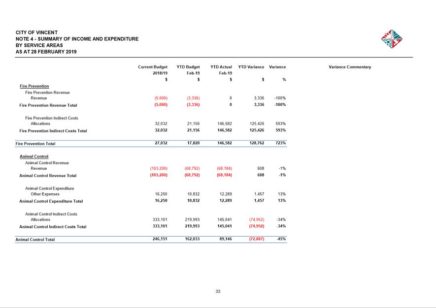
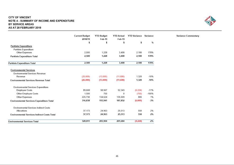
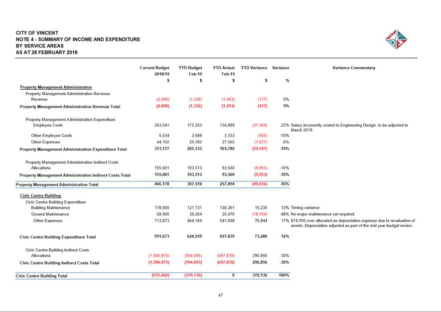
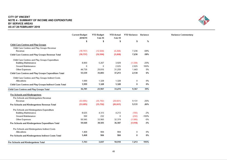
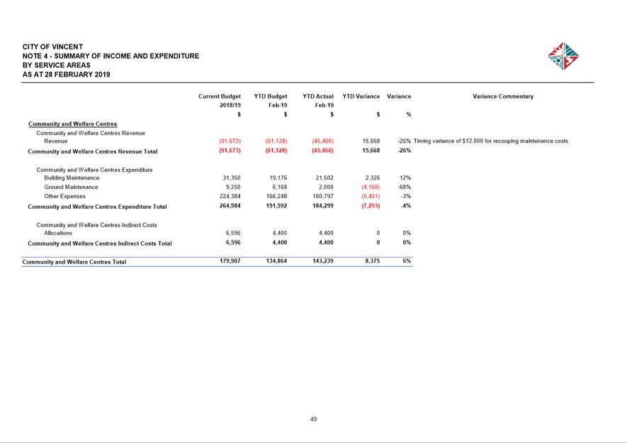
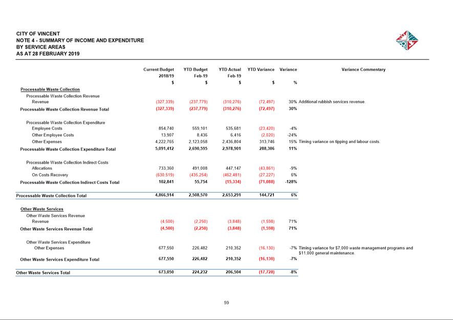
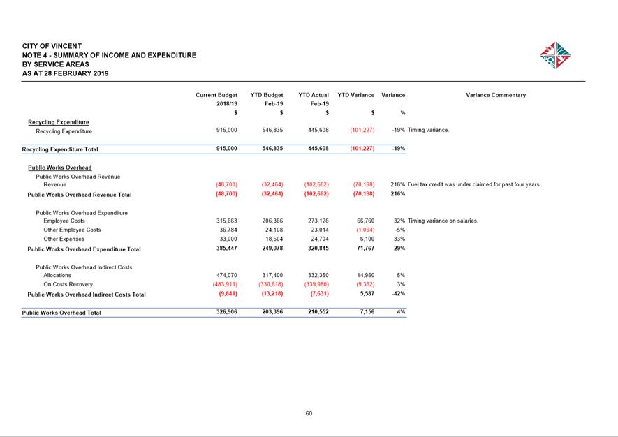
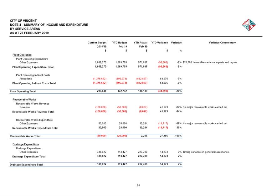
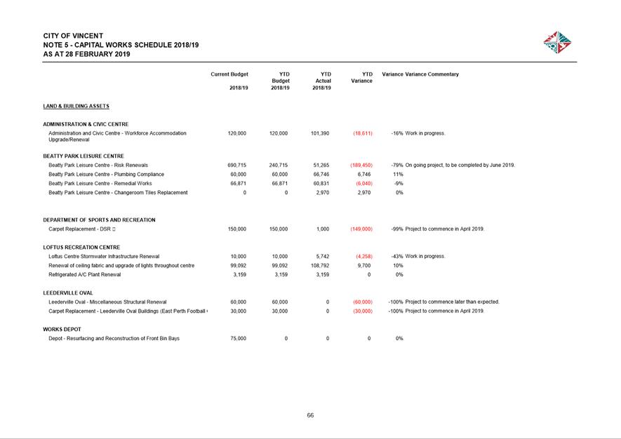
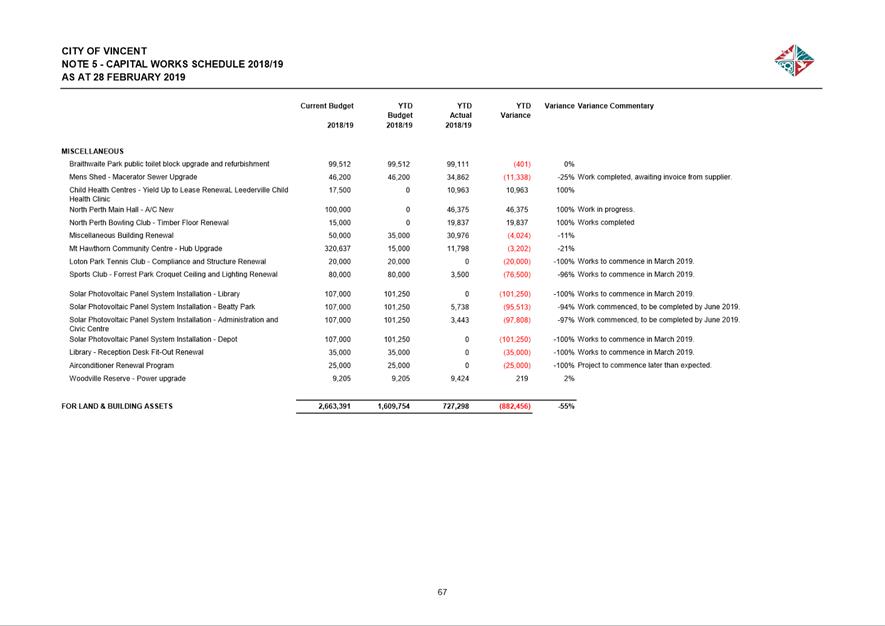
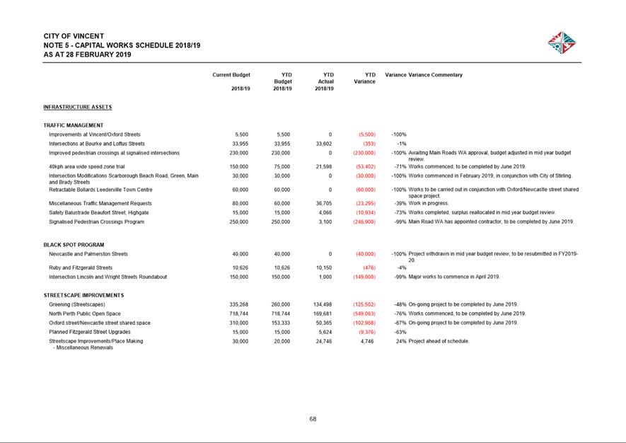
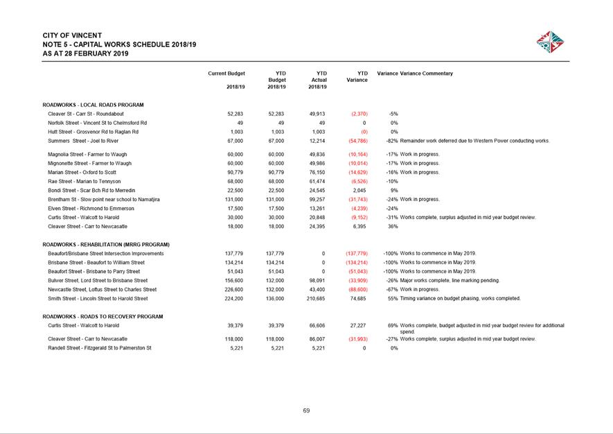
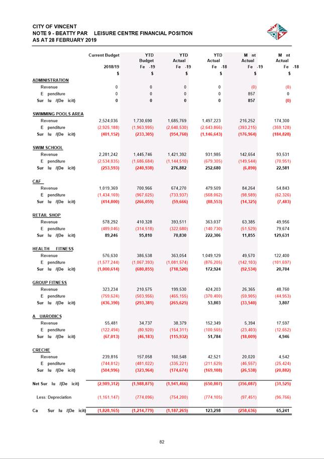
11.1 Investment Report as at 28 February 2019
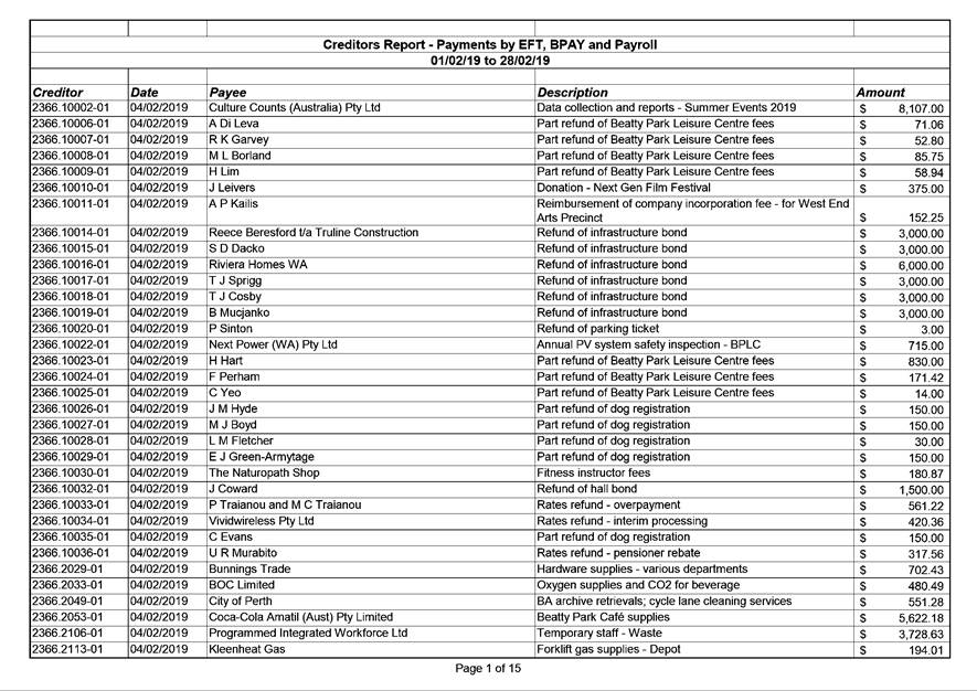
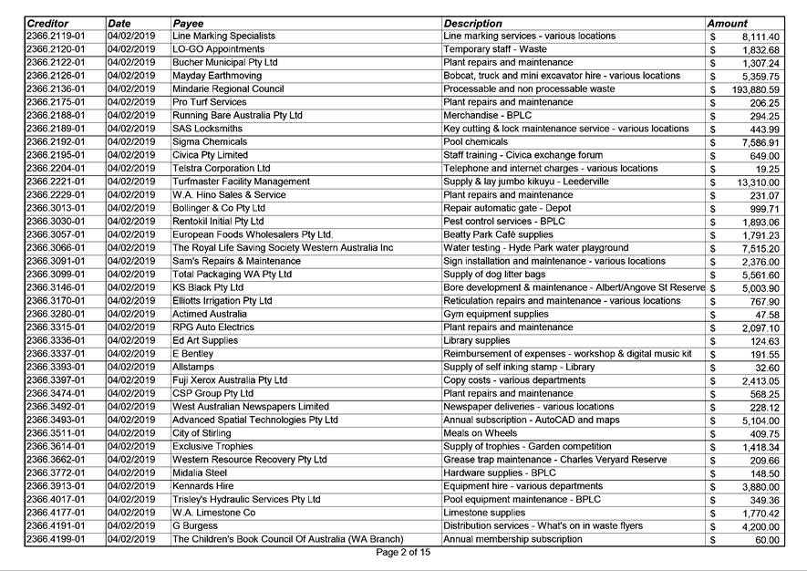
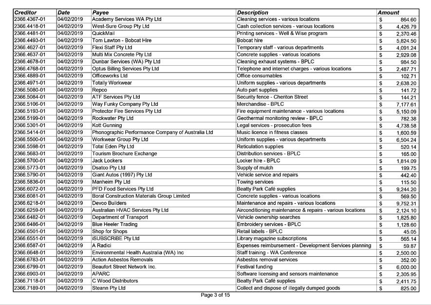
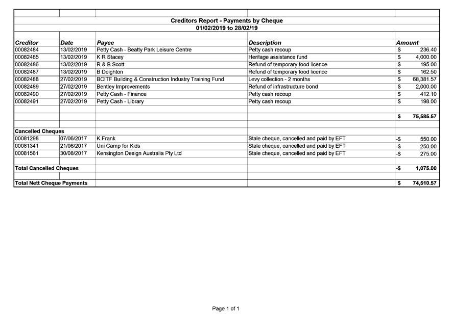
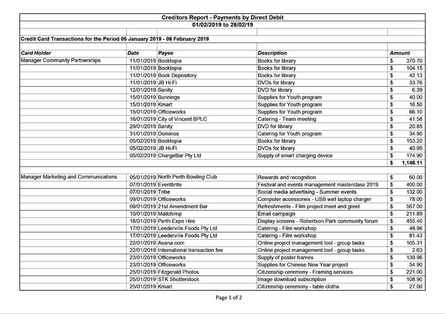
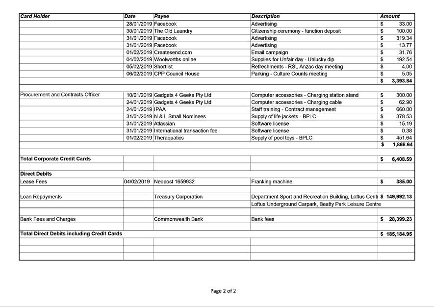
11.2 Authorisation of Expenditure for the Period 1 February 2019 to 28 February 2019
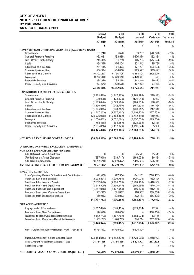
11.3 Financial Statements as at 28 February 2019
12.1 Draft City of Vincent 'Innovate' Reconciliation Action Plan 2019-2021
14 Motions of Which Previous Notice Has Been Given
14.1 Notice of Motion - Cr Topelberg - Tender or Quotations for Bulk Verge Collection
15 Questions by Members of Which Due Notice Has Been Given (Without Discussion)
16 Representation on Committees and Public Bodies
18 Confidential Items/Matters For Which The Meeting May Be Closed
“The City of Vincent would like to acknowledge the Traditional Owners of the land, the Whadjuk people of the Noongar nation and pay our respects to Elders past, present and emerging”.
2 Apologies / Members on Leave of Absence
Nil
3 (A) Public Question Time and Receiving of Public Statements
(B) Response to Previous Public Questions Taken On Notice
4 Applications for Leave of Absence
Mayor Emma Cole requests a leave of absence from 3 April 2019 to 6 April 2019 inclusive for personal reasons.
Cr Dan Loden requests a leave of absence from 9 April 2019 to 25 April 2019 inclusive for personal
reasons.
Cr Alex Castle requests a leave of absence from 17 April 2019 to 29 April 2019 inclusive for personal reasons.
Cr Joanne Fotakis requests a leave of absence from 19 April 2019 to 29 April 2019 inclusive for personal reasons.
5 The Receiving of Petitions, Deputations and Presentations
Ordinary Meeting - 5 March 2019
7 Announcements by the Presiding Member (Without Discussion)
Financial Interest – Item 5.9 - Cr Josh Topelberg - applicant is a current client of Cr Topelberg’s business. Cr Topelberg is not seeking approval to participate in the debate or remain in the Chambers or vote on the matter.
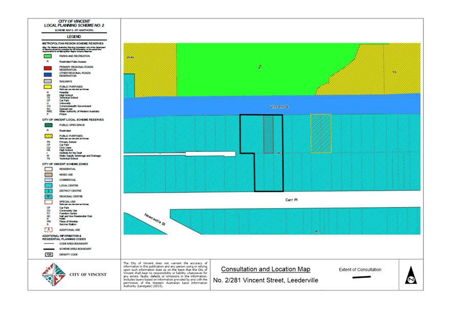
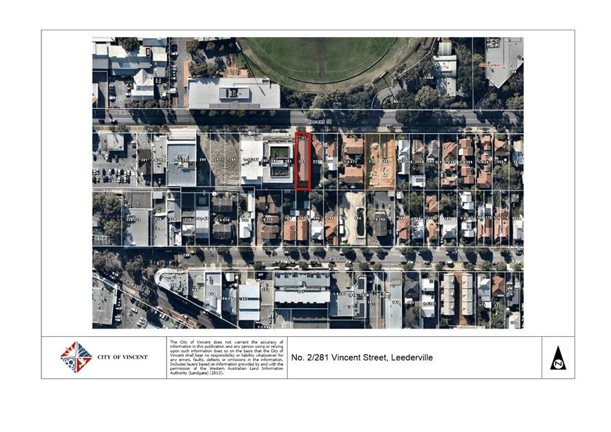
9.1 No. 1/281 (Lot: 1; STR: 73298) and No. 2/281 (Lot: 2; STR: 73298) Vincent Street, Leederville - Proposed Change of Use from Home Office to Office
TRIM Ref: D19/32073
Author: Dan McCluggage, Urban Planner
Authoriser: Joslin Colli, A/Manager Development & Design
Ward: South
Attachments: 1. Attachment
1 - Location and Consultation Plan ⇩ ![]()
2. Attachment 2 -
Development Plans ⇩ ![]()
3. Attachment 3 -
Summary of Submissions and Administrations Response ⇩ ![]()
4. Attachment 4 -
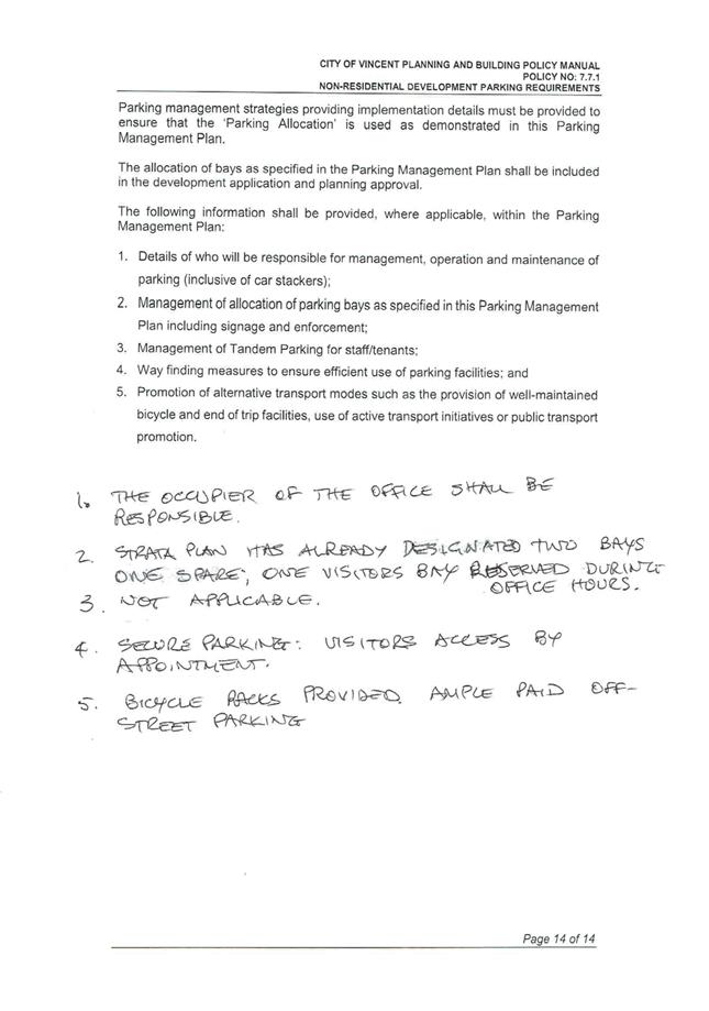
Parking Management Plan ⇩ ![]()
5. Attachment 5 -
Minutes of the Ordinary Meeting of Council held on 18 December 2012 (Previous
Council Decision) ⇩ ![]()
6. Attachment 6 -
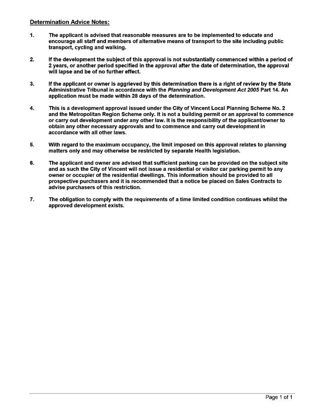
Determination Advice Notes ⇩ ![]()
|
That Council, in accordance with the provisions of the City of Vincent Local Planning Scheme No. 2 and the Metropolitan Region Scheme, APPROVES the application for development approval for a Change of Use from Home Office to Office at No. 1 (Lot: 1; STR: 73298) and No. 2/281 (Lot: 2; STR: 73298) Vincent Street, Leederville in accordance with the plans shown in Attachment 2, subject to the following conditions, with the associated determination advice notes in Attachment 6: 1. Use of Premises 1.1 This approval is for a change of use to ‘Office’ as shown on the plans dated 6 March 2019. It does not relate to any other development on the site; 1.2 The area shown as ‘Office’ on the approved plans shall be used in accordance with the definition of ‘Office’ as defined by the City’s Local Planning Scheme No. 2; 1.3 A maximum of four staff are permitted to be on-site at any given time; and 1.4 The Office shall not operate outside of the following times without further approval from the City of Vincent: · 8:00am – 6:00pm Monday – Friday; · 8:00am – 1:00pm Saturday; · CLOSED Sunday and Public Holidays; 2. Interactive Frontage The development shall maintain an active and interactive relationship and uninterrupted views between the use of the development and Vincent Street during the hours of the development’s operation to the satisfaction of the City. Darkened, obscured, mirror or tinted glass or the like is prohibited. Curtains, blinds and other internal or external treatments that obscure the view of the internal area from Vincent Street are not permitted to be used during the hours of the developments operation; 3. Parking Management Plan The Parking Management Plan approved as part of this application shall be implemented to the satisfaction of the City prior to the use or occupation of the development; 4. Bicycle Parking A minimum of one class 3 bicycle facility for the Office shall be provided on-site and be designed and installed in accordance with AS2890.3, to the satisfaction of the City, prior to the occupation or use of the development; and 5. Signage Any new signage shall be in strict accordance with the requirements of the City’s Policy No. 7.5.2 – Signs and Advertising, unless further planning approval is granted by the City. |
Purpose of Report:
To consider an application for development approval for a Change of Use from Home Office to Office at No. 1/281 Vincent Street and No. 2/281 Vincent Street, Leederville (the subject site).
PROPOSAL:
The application proposes to change the use of the subject site from Home Office to Office. Details of the proposal include:
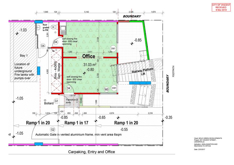
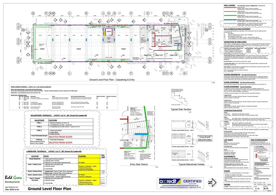
· Partially removing the internal wall between Unit 1 and Unit 2 to create one larger tenancy of 31.03 square metres;
· Changing the use of Unit 1 and Unit 2 from Home Office to Office. According to the applicant the existing home offices are currently untenanted and changing the use to Office would allow for leasing to a third party;
· A total of four to six persons would be employed by the business, with three to four persons working on-site at any given time. The hours of operation are recommended to be conditioned to limit the operation of the office land use from between 8:00am and 6:00pm Monday to Friday and 8:00am – 1:00pm Saturday (closed on Sundays and Public Holidays); and
· The application does not propose any external works to the existing building.
The proposed development plans are included as Attachment 2.
Background:
|
Landowner: |
Andrew Young (Unit 1) Peter Taylor (Unit 2) |
|
Applicant: |
Peter Taylor |
|
Date of Application: |
26 November 2018 |
|
Zoning: |
MRS: Urban LPS2: Zone: Regional Centre R Code: N/A |
|
Built Form Area: |
Town Centre |
|
Existing Land Use: |
Home Office |
|
Proposed Use Class: |
Office ‘D’ |
|
Lot Area: |
521m2 |
|
Right of Way (ROW): |
No |
|
Heritage List: |
No |
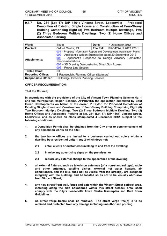
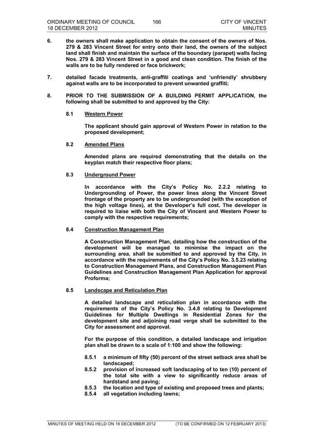
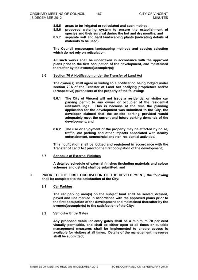
At the Ordinary Council Meeting on 18 December 2012, Council approved a development application for a four storey building on the subject site, consisting of ten multiple dwellings and two home offices.
The subject site is bounded by Vincent Street to the north, a single storey single house to the east at No. 279 Vincent Street, a single storey single house to the south at No. 200 Carr Place and a six storey multiple dwelling development to the west at No. 285 Vincent Street.
The subject site is zoned Regional Centre under Local Planning Scheme No. 2 (LPS2) and the subject site and adjoining properties are within the Town Centre built form area under the City’s Policy No. 7.1.1 – Built Form.
The subject site is affected by Clause 32(1) of LPS2, which states that an Office land use is not permitted on the ground floor or at grade level with the street within the Regional Centre zone unless the application has been assessed and advertised to adjoining residents in accordance with Clause 34 of LPS2.
Details:
Summary Assessment
The table below summarises the planning assessment of the proposal against the provisions of the City of Vincent LPS2 and the City’s Policy No. 7.7.1 – Non-Residential Development Parking Requirements (Parking Policy). In each instance where the proposal requires the discretion of Council, the relevant planning element is discussed in the Detailed Assessment section following from this table.
|
Planning Element |
Use Permissibility/ Deemed-to-Comply |
Requires the Discretion of Council |
|
Land Use |
|
ü |
|
Car Parking |
|
ü |
|
Bicycle Facilities |
ü |
|
Detailed Assessment
The deemed-to-comply assessment of the elements that require the discretion of Council are as follows:
|
Land Use |
|
|
Deemed-to-Comply Standard |
Proposal |
|
Local Planning Scheme No. 2
Clause 32(1) of LPS2 states that an Office land use is not permitted on the ground floor or at grade level with the street within the Regional Centre zone. |
The application proposes an Office land use on the ground floor within the Regional Centre zone. |
|
Car Parking |
|
|
Deemed-to-Comply Standard |
Proposal |
|
Policy No. 7.7.1
Office: 1.5 bays per 100sqm NLA
1.5 x 0.31 = 0.465 bays
1 car parking bay |
Nil |
The above elements of the proposal do not meet the specified deemed-to-comply standards and are discussed in the comments section below.
Consultation/Advertising:
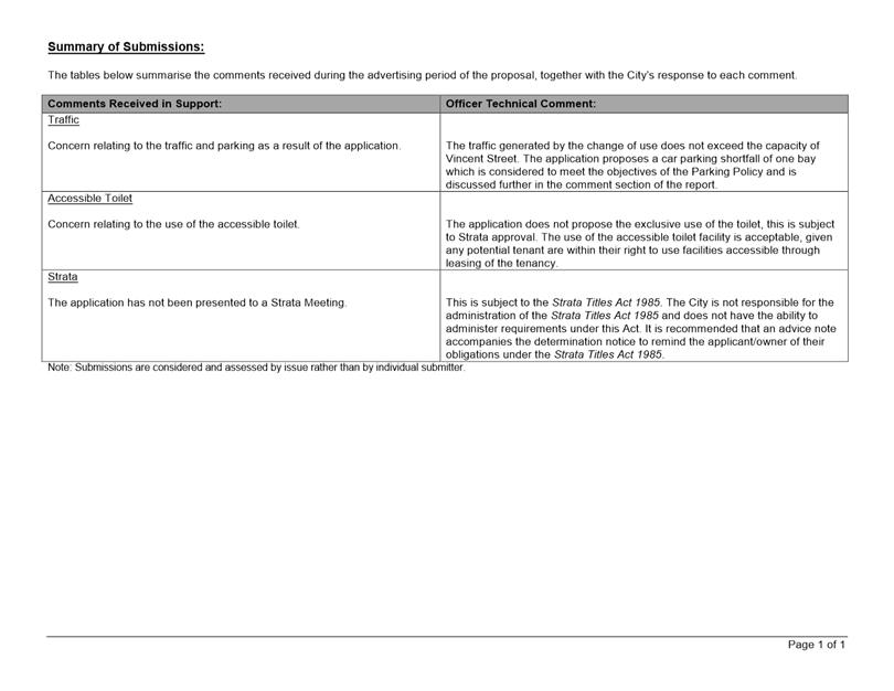
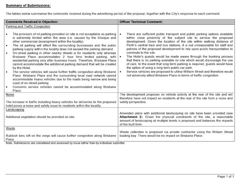
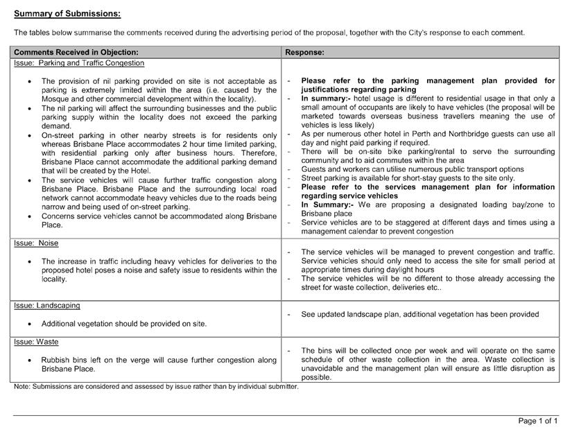
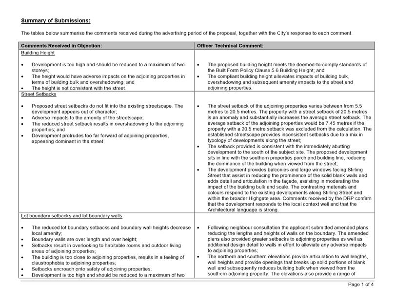
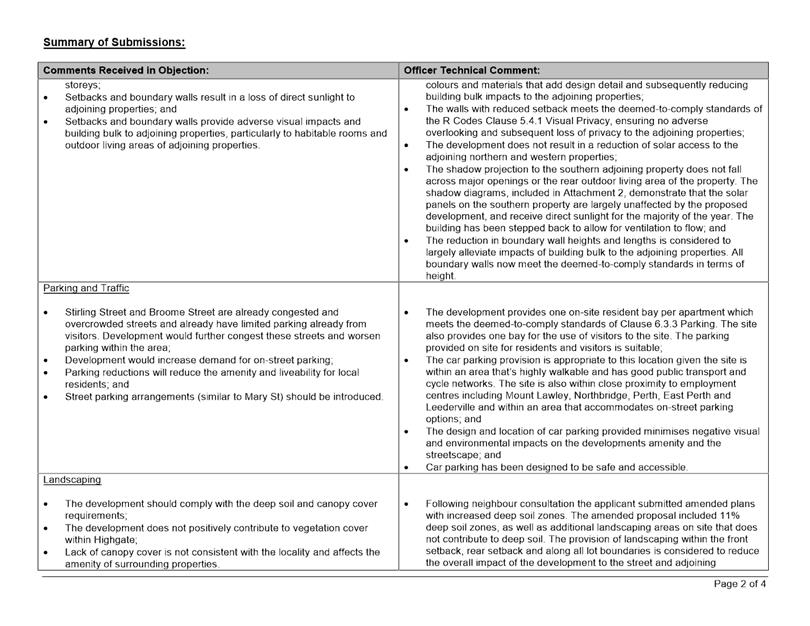
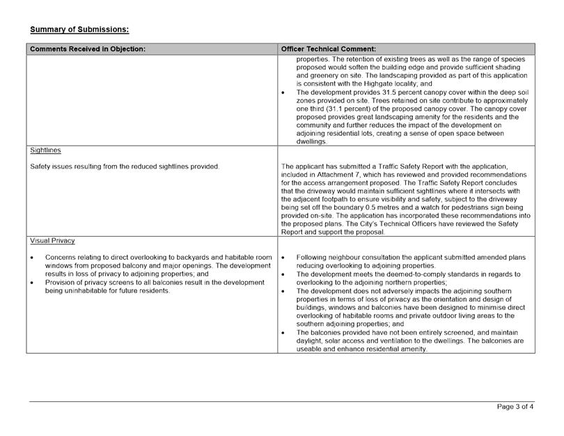
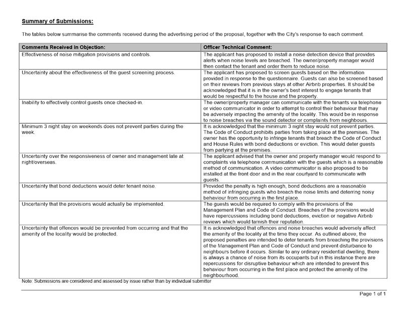
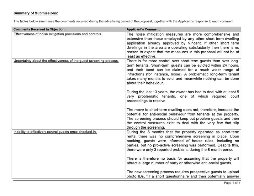
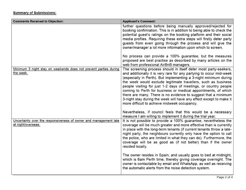
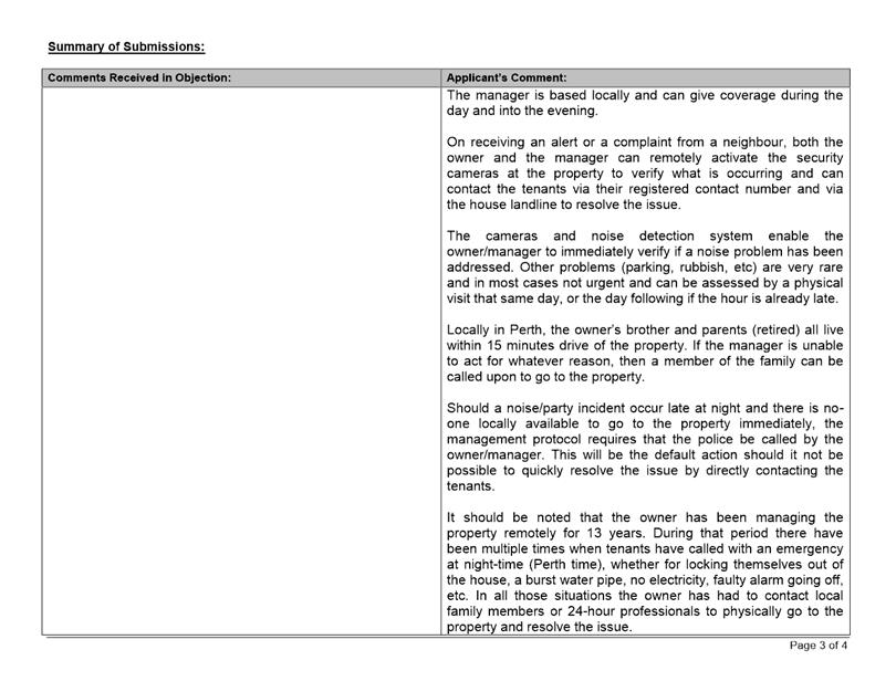
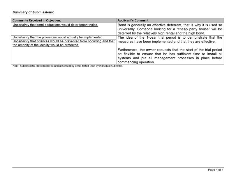
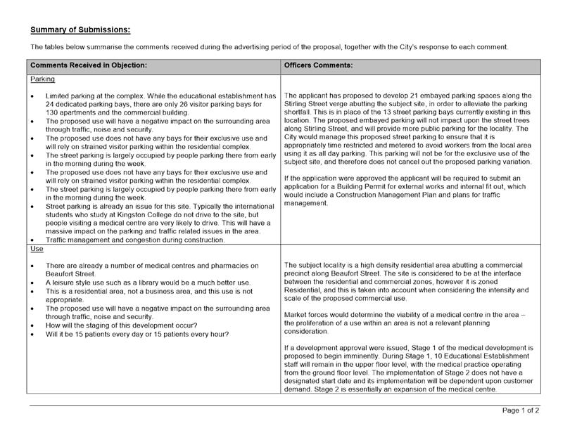
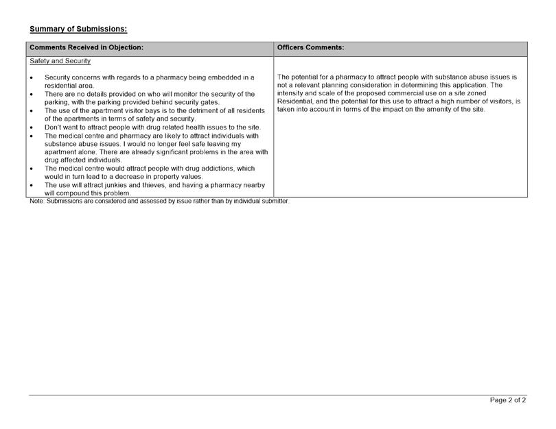
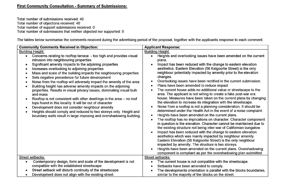
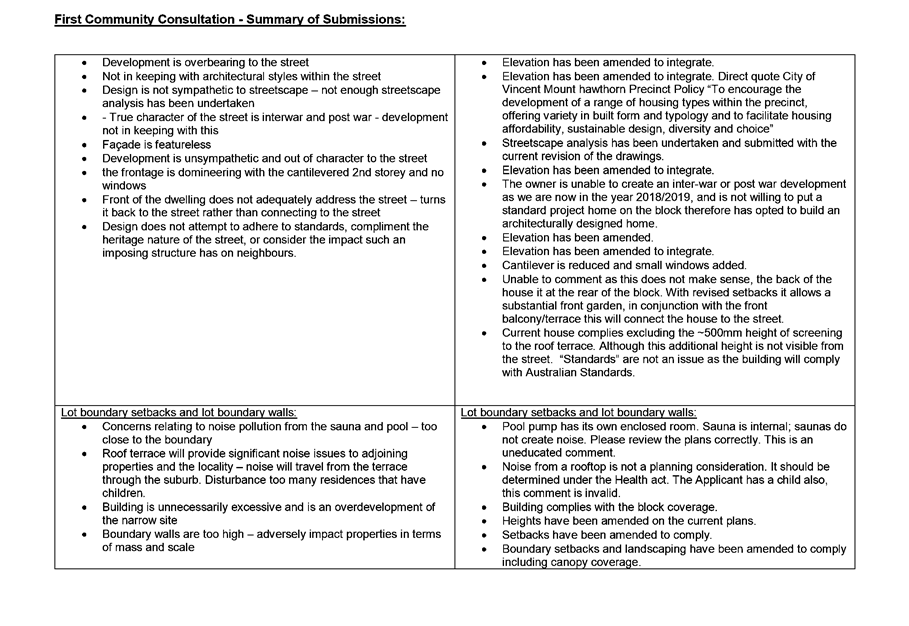
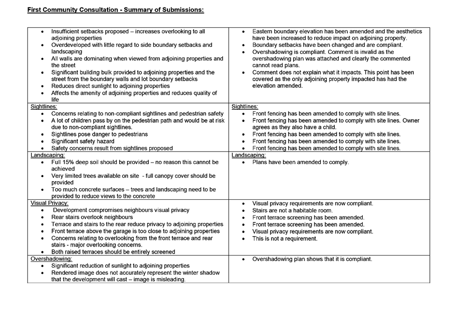
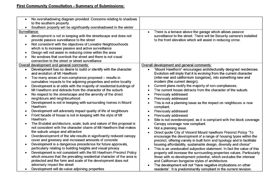
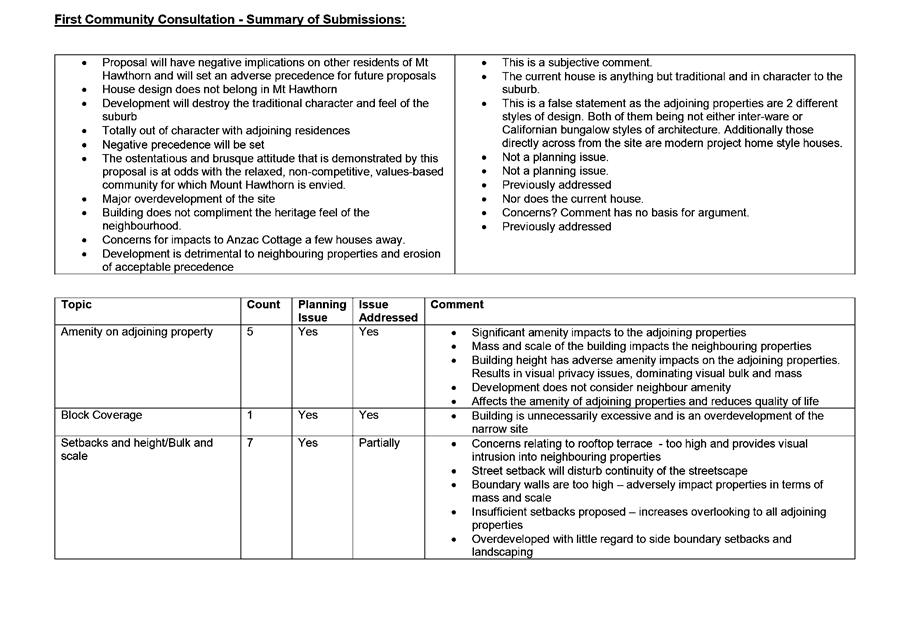
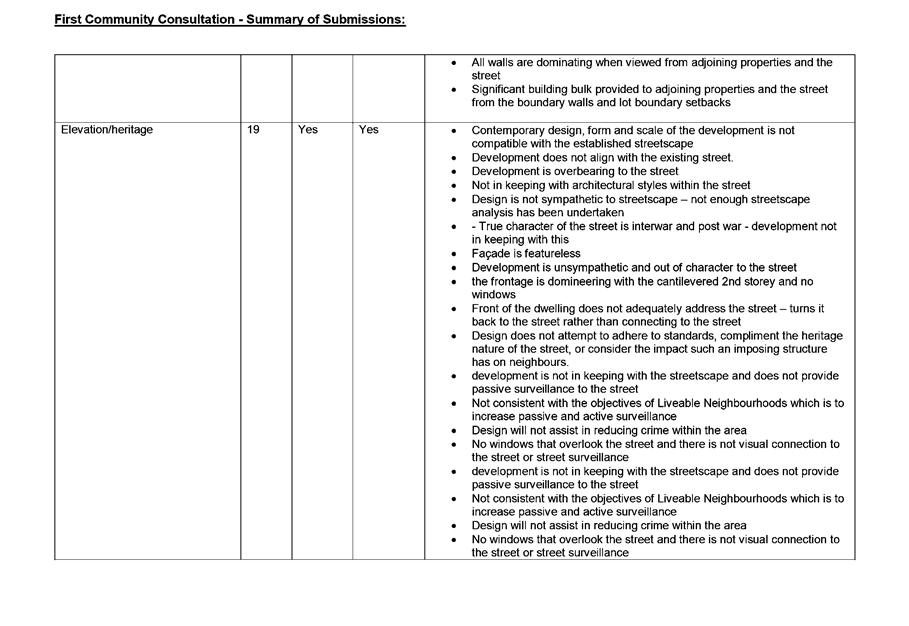
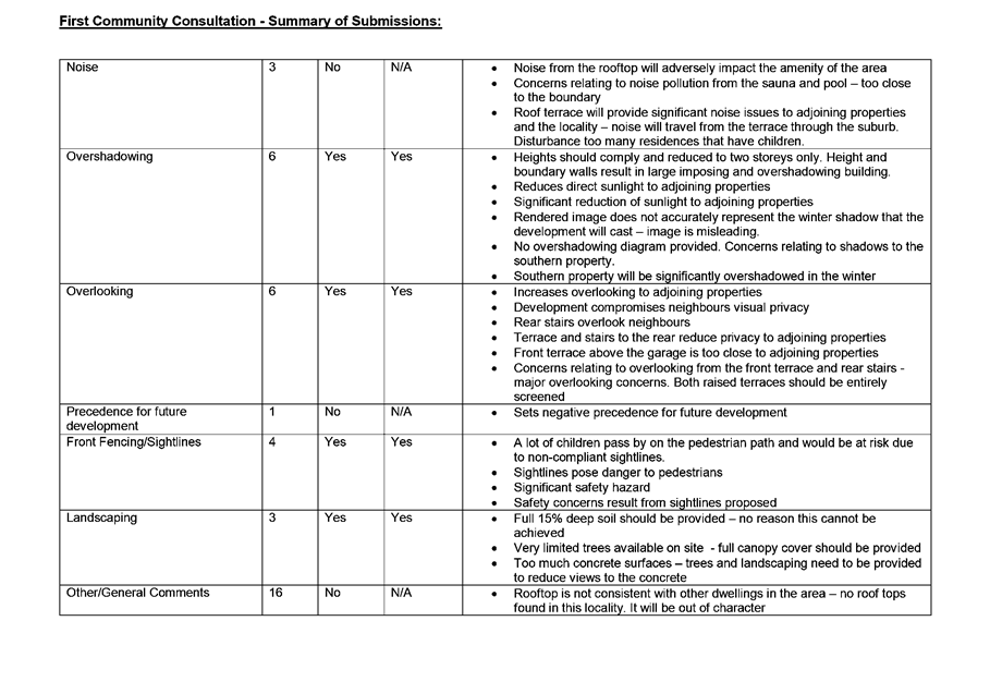
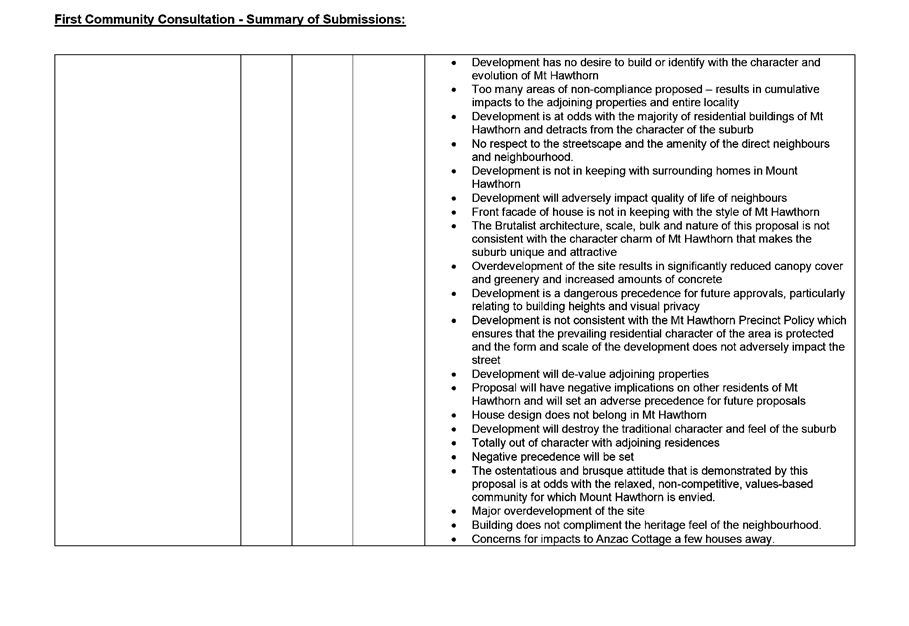
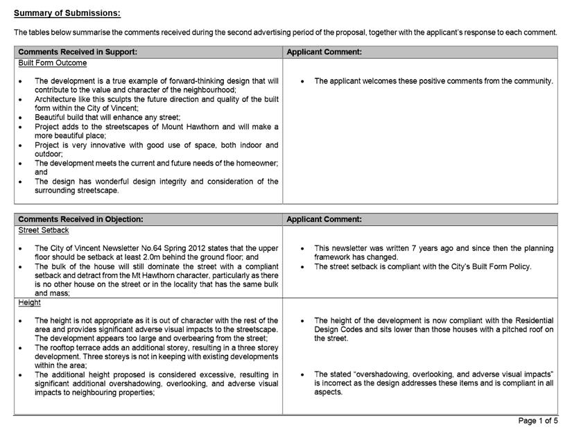
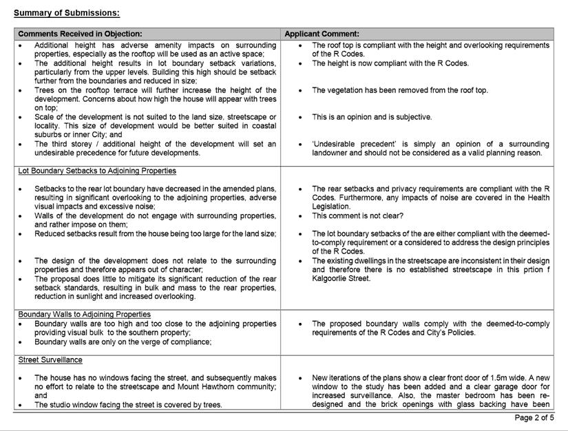
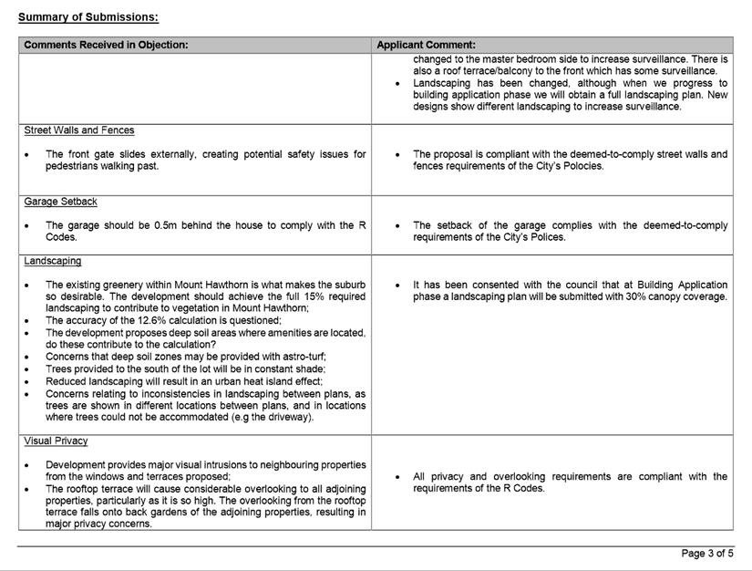
Community consultation was undertaken in accordance with the Planning and Development (Local Planning Schemes) Regulations 2015, for a period of 21 days commencing on 9 January 2019 and concluding on 30 January 2019. Community consultation was undertaken by means of a sign on site, a newspaper advert and 69 letters being sent to surrounding owners and occupiers, as shown in Attachment 1. The City received four submissions, all objecting to the proposal. A summary of the submissions received and Administration’s response is provided in Attachment 3.
The objections received predominately raised concerns in relation to the requirement for strata approval under the Strata Titles Act 1985. The City is not responsible for the administration of this Act and an advice note is recommended to be included on the determination notice to remind the applicant/owner of their obligations under this Act.
Design Review Panel (DRP):
Referred to DRP: No
Legal/Policy:
· Planning and Development Act 2005;
· Planning and Development (Local Planning Schemes) Regulations 2015;
· City of Vincent Local Planning Scheme No. 2;
· Policy No. 4.1.5 – Community Consultation; and
· Policy No. 7.7.1 – Non-Residential Development Parking Requirements.
Should Council refuse the application for development approval, the applicant will have the right to have the decision reviewed in accordance with Part 14 of the Planning and Development Act 2005.
Delegation to Determine Applications:
This matter is being referred to Council for determination as the Applicant has requested that the requirement to pay cash-in-lieu in accordance with the Parking Policy be waived.
Risk Management Implications:
There are minimal risks to Council and the City’s business function when Council exercises its discretionary power to determine a planning application.
Strategic Implications:
This is in keeping with the City’s Strategic Community Plan 2018-2028:
Innovative and Accountable
We are open and accountable to an engaged community.
SUSTAINABILITY IMPLICATIONS:
Nil.
Financial/Budget Implications:
Should the Council waive the cash-in-lieu requirement, the City would not receive the $2,511 payment that is required under the Parking Policy.
Comments:
Land Use
Clause 32(1) of LPS2 states that an Office land use is not permitted on the ground floor or at grade level with the street within the Regional Centre zone. Notwithstanding this, an Office use is capable of being approved in accordance with Clause 34(2) of LPS2 provided that the City is satisfied that the proposal satisfies the following criteria of Clause 34(5):
(a) approval of the proposed development would be appropriate having regard to the matters that the local government is to have regard to in considering an application for development approval as set out in clause 67 of the deemed provisions; and
(b) the non-compliance with the additional site and development requirement will not have a significant adverse effect on the occupiers or users of the development, the inhabitants of the locality or the likely future development of the locality.
With regard to a) above, the proposed Office use is appropriate having regard to the matters to be considered by local government set out in Clause 67 of the Planning and Development (Local Planning Schemes) Regulations 2015 deemed provisions for the following reasons:
· The office land use is consistent with the objectives of the Regional Centre zone under LPS2, specifically:
o Increasing the range of services and uses to cater for the local community; and
o Broadening the range of employment opportunities within the area;
· The existing courtyards between the proposed office tenancy and the street provide adequate opportunity for interaction between the development and the public realm as well as passive street surveillance. A condition is recommended to ensure that an interactive frontage is maintained;
· The proposal provides increased employment opportunities within the Leederville Town Centre, noting that the subject site is currently vacant. This reflects the intent of the planning framework for the locality including the Leederville Masterplan;
· Vincent Street is characterised by single, grouped and multiple dwellings, retail, café and office land uses. The western adjoining lots include multiple dwellings with commercial and office land uses at ground level. The eastern adjoining lots include single dwellings. The northern adjoining lots include public office buildings. Given this, the application is in line with and reflective of the existing character and land uses of the locality;
· The proposal meets the objectives of the City’s Parking Policy and is unlikely to generate traffic that exceeds the capacity of the existing road system in the locality, as discussed in further detail below.
With regard to b) above, the consultation process undertaken in relation to the proposal has identified that the office land use would not significantly adversely impact on the occupiers or users of the development, the inhabitants of the locality or the likely future development of the locality.
It is unlikely that the proposed low scale office with a NLA of 31.03 square metres would result in a land use with a greater intensity or amenity impact than that of other land uses that are permitted within the Regional Centre zone under LPS2 including shop, restaurant/café, liquor store – small, lunch bar and convenience store.
As outlined in the Consultation/Advertising section of this report, the four objections received during the consultation period raised concerns in relation to the requirement for strata approval under the Strata Titles Act 1985 as opposed to concerns relating to planning matters. A summary of the submissions received and the Administration’s response is provided in Attachment 3.
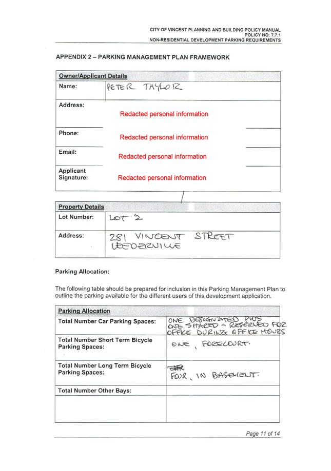
Car Parking
In accordance with the City’s Parking Policy, an office at the subject site is required to provide 1.5 spaces per 100 square metres of net leasable area (NLA) on-site. The proposal requires one (rounded up from 0.465) parking space based on 31.03 square metres of NLA.
The existing development on site provides compliant resident parking and a one bay visitor parking shortfall in accordance with the approval granted by Council at its meeting on 18 December 2012. Whilst there are twelve parking spaces within the existing development to service the ten multiple dwellings, there are no parking spaces allocated to the two home offices. This results in a car parking shortfall of one space when considering the current proposal.
In considering the proposed car parking shortfall, the following is relevant:
· The proposed office with a net leasable area of 31.03 square metres is relatively small in comparison to other office space located along Vincent Street and is likely to have minimal visitors and associated vehicle movements during operating hours in comparison to other uses, such as medical centre, consulting rooms, café or retail land uses;
· The development is proposed to be conditioned for a maximum of four staff at any one time;
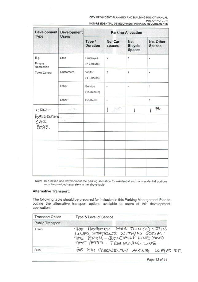
· The proposal is located within a well-serviced area, in relation to access, public transport and sustainable modes of transport;
o The subject site is located approximately 580 metres from the Leederville Train Station by constructed footpaths;
o The subject site is located approximately 200 metres from an existing high frequency bus route, as defined in the Residential Design Codes, running along Oxford Street;
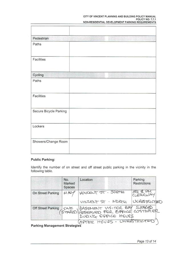
· Ticketed on-street car parking is available directly adjacent to the subject site along Vincent Street. These on-street car bays are subject to a clearway parking restrictions from 7:30am to 9:00am and 4:15pm to 6:00pm Monday to Friday but are otherwise unrestricted. These bays are generally used by residents and visitors to the businesses and dwellings along this section of Vincent Street;
· The existing development on site provides compliant bicycle parking in accordance with the approval granted by Council at its meeting on 18 December 2012. Whilst the proposal does not require any additional bicycle parking facilities to be provided on site in accordance with the City’s Parking Policy, the applicant has agreed to provide one class 3 bicycle facility on-site. A condition of approval is recommended to ensure that this facility is provided accordingly; and
· The car parking provided satisfies the objectives of the City’s Parking Policy and is acceptable to service the development without the provision of a cash-in-lieu contribution.
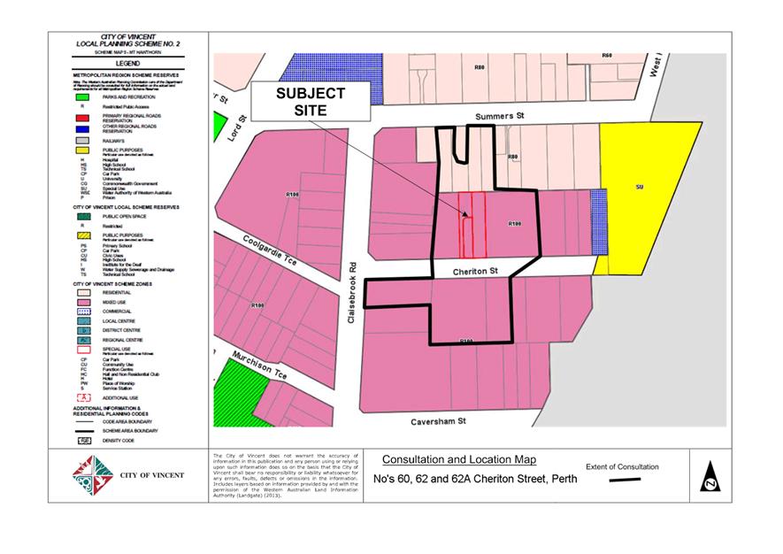
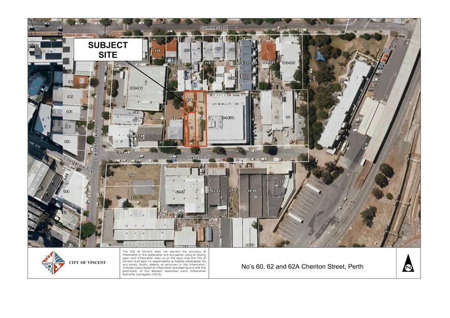
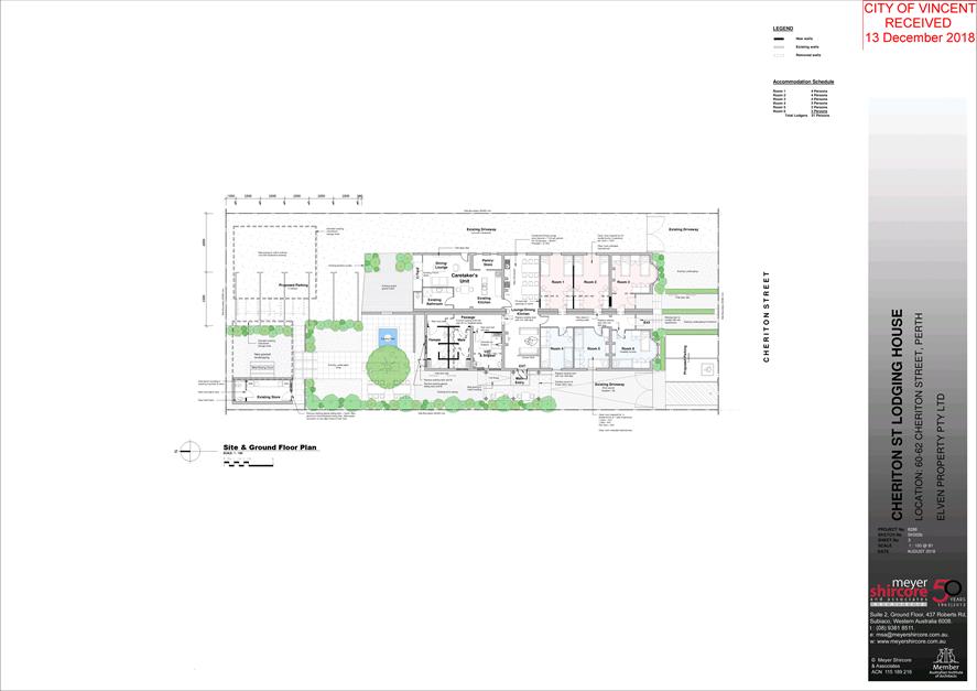
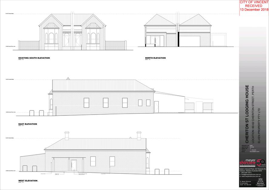
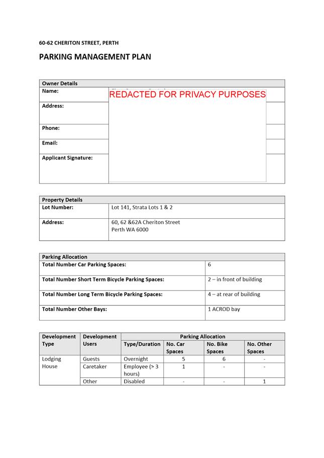
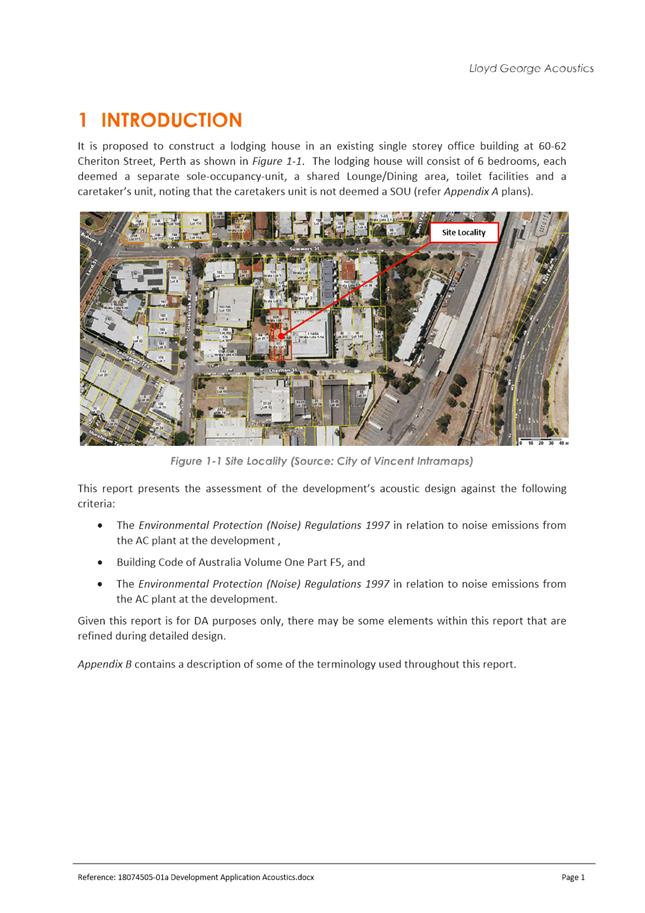
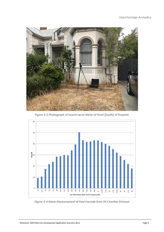
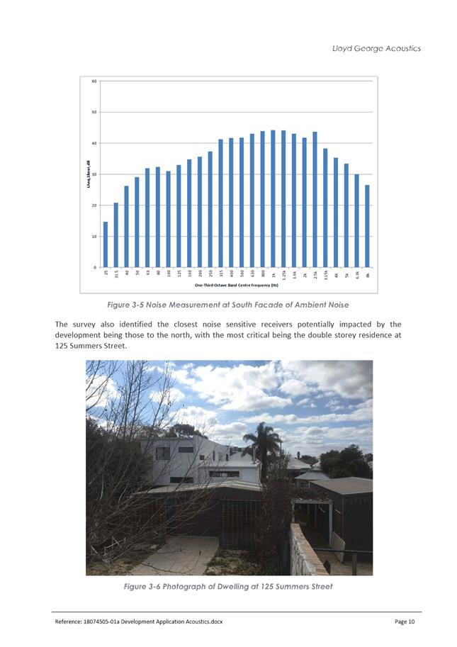
9.2 No. 60 (Lot: 141 D/P: 32175), No. 62 (Lot: 1 STR: 44480) and No. 62A (Lot: 2 STR: 44480) Cheriton Street, Perth - Change of Use to Unlisted Use (Lodging House)
TRIM Ref: D19/16365
Author: Mitchell Hoad, Senior Urban Planner
Authoriser: Joslin Colli, A/Manager Development & Design
Ward: South
Attachments: 1. Attachment
1 - Location and Consultation Plan ⇩ ![]()
2. Attachment 2 -
Development Plans ⇩ ![]()
3. Attachment 3 -
Parking Management Plan ⇩ ![]()
4. Attachment 4 -
Acoustic Report ⇩ ![]()
5. Attachment 5 -
Management Plans ⇩ ![]()
6. Attachment 6 -
Determination Advice Notes ⇩ ![]()
|
That Council, in accordance with the provisions of the City of Vincent Local Planning Scheme No. 2 and the Metropolitan Region Scheme, APPROVES the application for a Change of Use from Grouped Dwellings to Caretaker’s Dwelling and Unlisted Use (Lodging House) at No. 60 (Lot: 141; D/P: 32175), No. 62 (Lot: 1; STR: 44480) and No. 62A (Lot: 2; STR: 44480) Cheriton Street, Perth, in accordance with the plans shown in Attachment 2 and the determination advice notes at Attachment 6: 1. Use of Premises 1.1 This approval relates to a Change of Use from Grouped Dwellings to Caretaker’s Dwelling and Unlisted Use (Lodging House) as shown on the plans dated 13 December 2018. It does not relate to any other development on the site; 1.2 The use of the ‘Caretaker’s Unit’ as shown on the plans dated 13 December 2018 shall only be used in accordance with the definition of Caretaker’s Dwelling as defined in the City of Vincent’s Local Planning Scheme No. 2 as follows: “A dwelling on the same site as a building, operation or plant used for industry, and occupied by a supervisor of that building, operation or plant.”; 1.3 The occupant of the Caretaker’s Dwelling shall reside permanently on the site; 1.4 A minimum of one on-site car parking bay shall be made available for the Caretaker’s Dwelling to be used by the occupant, at all times; and 1.5 A maximum of 25 people are permitted on the site at any one time, being comprised of one caretaker and 24 guests; 2. Parking and Access 2.1 A minimum of seven off-street parking bays shall be provided. The parking bays are not to be used for storage purposes or the like; 2.2 The car parking and access areas shall be sealed, drained, paved and line marked in accordance with the approved plans and are to comply with the requirements of AS2890.1 prior to the occupation or use of the development; and 2.3 A minimum of six bicycle facilities shall be provided and designed in accordance with AS2890.3 prior to the occupation of the premises; 3. Management Plan 3.1 Prior to occupation, a Management Plan is to be submitted to and approved by the City, that addresses the control of anti-social behaviour (to reasonable levels) associated with the proposed use. The Management Plan is to be approved by the City and thereafter implemented to the City’s satisfaction, and is to consider the following: · A complaints management procedure, detailing how complaints and incidents will be managed should they occur; and · A code of conduct outlining the expectations of guests during their stay. The approved Management Plan shall be reviewed after 12 months, with any changes identified during this review or by the City, being incorporated into an updated Management Plan, to be approved by the City and thereafter implemented; and 3.2 The code of conduct outlined in the amended Management Plan required by Condition 3.1 shall be provided to guests at the time of check-in and displayed in a prominent location within the premises; 4. Stormwater All stormwater produced on the subject land shall be retained on site, by suitable means to the satisfaction of the City; 5. Acoustic Report 5.1 A revised Acoustic Report shall be lodged with and approved by the City, in accordance with the City’s Policy No. 7.5.21 – Sound Attenuation prior to the commencement of the development; and 5.2 All of the recommended measures included in the approved revised Acoustic Report shall be implemented prior to the occupation or use of the development and maintained thereafter to the satisfaction of the City at the expense of the owners/occupiers; and 6. Landscaping Plan 6.1 A detailed landscape and reticulation plan for the development site and adjoining road verge, to the satisfaction of the City, shall be lodged with and approved by the City prior to commencement of the development. the plan shall be drawn to a scale of 1:100 and show the following: · The location and type of existing and proposed trees and plants; · Areas to be irrigated or reticulated; · The provision of 14.3 per cent of the site area as deep soil zones; and · The appropriate selection of tree species (consistent with the City’s Tree Selection Tool) to be located within the deep soil areas to maximise the provision of canopy coverage; and 6.2 All works shown in the plans identified in Condition 6.1 above shall be undertaken in accordance with the approved plans to the City’s satisfaction, prior to occupancy or use of the development and maintained thereafter to the satisfaction of the City at the expense of the owners/occupiers. |
Purpose of Report:
To consider an application for development approval for a Change of Use to a Caretaker’s Dwelling and Unlisted Use (Lodging House) at Nos. 60, 62 and 62A Cheriton Street, Perth (subject site).
PROPOSAL:
The application proposes a Change of Use from Grouped Dwelling to a Caretaker’s Dwelling and Unlisted Use (Lodging House) at the subject site to provide accommodation for students, staff and guest lecturers of community organisation Youth With A Mission (YWAM).
Background:
|
Landowner: |
Eshwar Holdings Pty Ltd |
|
Applicant: |
Meyer Shircore Architects |
|
Date of Application: |
7 August 2018 |
|
Zoning: |
MRS: Urban LPS2: Zone: Mixed Use R Code: R100 |
|
Built Form Area: |
Mixed Use |
|
Existing Land Use: |
Grouped Dwelling |
|
Proposed Use Class: |
Caretakers Dwelling and Unlisted Use (Lodging House) |
|
Lot Area: |
1,013 square metres |
|
Right of Way (ROW): |
No |
|
Heritage List: |
No |
The subject site is zoned Mixed Use R100 under the City of Vincent Local Planning Scheme No. 2 (LPS2) and currently consists of two Grouped Dwellings.
The subject site is bound by Cheriton Street to the south, No 64 Cheriton Street to the west, No. 54 Cheriton Street to the east, and No. 121 and 125 Summers Street to the north. The sites to the east, west and south are also zoned Mixed Use R100 while the properties to the north are zoned Residential R80.
A location plan is included as Attachment 1.
The application was lodged with the City on 7 August 2018 but was incomplete. Following a preliminary assessment Administration requested additional information to be provided to allow a full assessment to be undertaken, including a description of the operation of the lodging house, a management plan, an acoustic report and a Parking Management Plan (PMP). This information was provided to the City on 13 December 2018, after which the application was assessed and progressed.
Recent Approvals
On 1 April 2015, the Metro West JDAP granted development approval for the construction of an eight storey mixed use development on the subject site. This approval was not enacted upon and has since lapsed.
On 4 November 2015, the Western Australian Planning Commission (WAPC) approved an application to amalgamate the three lots which are the subject of this application into one (reference WAPC 152423). The City issued subdivision clearance on 21 June 2018 and at the time of considering the development application the deposited plan had yet to be approved by Landgate.
Details:
The application proposes to change the use of the subject site from Grouped Dwelling to Caretaker’s Dwelling and Unlisted Use (Lodging House) to provide accommodation for students, staff and guest lecturers of YWAM. YWAM is a non-profit Christian missionary organisation which provides local ministry and field-focused training for youths within cities.
The details of the application include:
· The lodging house would accommodate a maximum of 24 persons at any one time. The anticipated age of lodgers is 18 to 30 years old. There would be a minimum stay of one week and maximum stay of six months. The accommodation is only for use by those associated with YWAM and would not be made available to anyone outside of the organisation. In addition there would be one caretaker permanently residing on the site to assist with managing and maintaining the premises and dealing with complaints;
· The complete demolition of the existing shed located at the rear of No. 60, and the partial demolition of the existing shed at the rear of No. 62A to be converted into a 17 square metre storeroom;
· The installation of approximately 145 square metres of deep soil landscaping;
· The construction of seven car parking bays including one universal access parking bay. Two bays, including the universal access bay are located at the front adjacent to Cheriton Street and the remaining five bays located at the rear of the subject site. In addition a total of six bicycle parking spaces are proposed;
· External changes to the existing building including the removal of existing door to the rear of the building and the replacement of existing doors with wider doors to accommodate universal access; and
· Internal changes included the replacement of existing doors with wider doors to accommodate universal access as well as the construction of new walls and the conversion of existing rooms into a toilet and shower area.
The development application plans are included as Attachment 2. The applicant has also provided a Parking Management Plan (PMP), Acoustic Report and a management plan for the premises, which are included as Attachments 3, 4 and 5 respectively.
Summary Assessment
The table below summarises the planning assessment of the proposal against the provisions of the City of Vincent Local Planning Scheme No. 2 (LPS2), and the City’s Policy No. 7.7.1 – Non-Residential Development Parking Requirements (Parking Policy) and Policy No. 7.4.5 – Temporary Accommodation (Temporary Accommodation Policy). In each instance where the proposal requires the discretion of Council, the relevant planning element is discussed in the Detailed Assessment section following from this table.
|
Planning Element |
Use Permissibility/ Deemed-to-Comply |
Requires the Discretion of Council |
|
Land Use |
|
ü |
|
Parking and Access |
|
ü |
|
Management Plan |
|
ü |
|
Landscaping |
|
ü |
|
Acoustic Report |
ü |
|
Detailed Assessment
The deemed-to-comply assessment of the elements that require the discretion of Council are as follows:
|
Land Use |
|
|
Deemed-to-Comply Standard |
Proposal |
|
Local Planning Scheme No. 2
“P” use |
Unlisted Use (Lodging House) |
|
Parking and Access |
|
|
Deemed-to-Comply Standard |
Proposal |
|
Policy No. 7.7.1 – Non-Residential Development Parking Requirements
Unlisted Uses have no prescribed parking requirement under Table 1 of the Parking Policy, with parking to be determined by the City based on a site specific Parking Management Plan. |
The application proposes seven on-site car parking bays and is supported by a Parking Management Plan. |
|
Management Plan |
|
|
Deemed-to-Comply Standard |
Proposal |
|
Policy No. 7.4.5 – Temporary Accommodation
Provision of a management plan which includes control of noise, complaints management procedures, security, control of anti-social behaviour and commitment to advising occupiers of parking instructions. |
The application includes a management plan which outlines the provision of a designated caretaker, control of noise, complaints management procedures, guests’ security and control of anti-social behaviour. |
|
Landscaping |
|
|
Deemed-to-Comply Standard |
Proposal |
|
Policy No. 7.4.5 – Temporary Accommodation
Appropriate landscaping demonstrating the use of water conservation measures and paving to be provided that meets the needs of guests and enhances security, safety and amenity of the development and adjoining properties. |
The application includes a landscaping plan. |
The above elements of the proposal do not meet the specified deemed-to-comply standards and are discussed in the comments section below.
Consultation/Advertising:
Community consultation was undertaken in accordance with the Planning and Development (Local Planning Schemes) Regulations 2015, for a period of 21 days from 23 January 2019 to 13 February 2019. The method of consultation being a sign on site, an advertisement in the local newspaper, and 36 letters mailed to all owners and occupiers surrounding the site (as shown in Attachment 1), in accordance with the City’s Policy No. 4.1.5 – Community Consultation.
A total of three submissions were received, all of which provided support for the development. One of the submissions noted that a previous break in attempt had occurred to the properties along the rear of the subject site, with access being gained from No. 54 Cheriton Street to get across the subject site and to these properties. As the application proposes a permanent caretaker onsite, this would contribute towards passive surveillance of the area and dissuade anti-social behaviour.
Design Review Panel (DRP):
Referred to DRP: No
Legal/Policy:
· Planning and Development Act 2005;
· Planning and Development (Local Planning Schemes) Regulations 2015;
· City of Vincent Local Planning Scheme No. 2;
· Policy No. 4.1.5 – Community Consultation;
· Policy No. 7.1.1 – Built Form;
· Policy No. 7.2.21 - Sound Attenuation;
· Policy No. 7.4.5 – Temporary Accommodation; and
· Policy No. 7.7.1 – Non-Residential Development Parking Requirements.
In accordance with Schedule 2 Clause 76(2) of the Planning and Development (Local Planning Schemes) Regulations 2015 and Part 14 of the Planning and Development Act 2005, the applicant will have the right to apply to the State Administrative Tribunal for a review of Council’s determination.
Delegation to Determine Applications:
The application is required to be determined by Council as the development proposes a use which is not listed in Table 1 of the City’s Parking Policy.
Risk Management Implications:
There are minimal risks to Council and the City’s business function when Council exercises its discretionary power to determine a planning application.
Strategic Implications:
The City’s Strategic Plan 2013-2023 states:
Innovative and Accountable
We are open and accountable to an engaged community
SUSTAINABILITY IMPLICATIONS:
Nil.
Financial/Budget Implications:
Nil.
Comments:
Land Use
Within the Mixed Use zone, a Caretaker’s Dwelling is a permitted “P” use. The lodging house is not listed within the zoning table and is assessed in accordance with Clause 18(4) of LPS2. In considering the appropriateness of the use, regard is to be given to the objectives of the Mixed Use zone under LPS2.
The proposal is able to limit the impacts on the surrounding area, and is consistent with the objectives of the Mixed Use zone under LPS2 as follows:
· The proposed use is primarily residential in nature. While this use is not an active use it does not restrict or prohibit the ability for active uses to be accommodated in the locality;
· The applicant has provided a management plan with the proposal to demonstrate how the use will be managed so as to minimise any impacts on the adjoining properties. A PMP has also been prepared to demonstrate the adequacy of parking arrangements for the site. Both of these are discussed in more detail later in this report. These indicate that the use is capable of operating from the subject site without generating nuisances detrimental to the amenity of the adjoining properties or the wider locality;
· It could reasonably be considered that the proposal contributes towards sustainability through the adaptive reuse of an existing building. The retention of the existing dwellings will also assist in maintaining a residential scale of development to the adjoining Residential zoned land to the north; and
· The proposal provides an alternative form of residential accommodation which addresses the need for temporary accommodation for the YWAM community.
Parking
The Parking Policy does not specify parking requirements for the proposed use, with parking to be determined based on a PMP. The application proposes seven on-site car parking bays, including one ACROD parking bay, as well as six bicycle parking spaces. The application is supported by a PMP which is included in Attachment 3.
The PMP outlines the following:
· Of the seven car parking bays, one will be used by the caretaker, with the remaining six bays, (including the ACROD bay) and the six bicycle parking spaces to be available for use by guests;
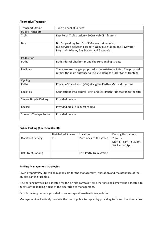
· The subject site is within proximity to alternative transport options. The subject site is approximately 600 metres from the East Perth Train Station and approximately 300 metres from a bus stop along Lord Street, providing services which connect to the Elizabeth Quay and Morley Bus Stations, Bayswater, Maylands, and Bassendean;
· End of trip facilities are provided within the premises and the subject site is in proximity to the Principle Shared Path along the Midland Train Line. There are also footpaths provided along both sides of Cheriton Street and the surrounding streets;
· There are 28 on-street parking spaces provided along both sides of Cheriton Street, which is restricted to 2 hour parking between 8:00am to 5:30pm Monday to Friday and 8:00am to 12:00pm Saturday; and
· Management will actively promote the use of public transport by providing train and bus timetables.
The proposed parking provision is suitable for the following reasons:
· Given the nature of the use, with the accommodation being used by students, staff and guest lecturers of YWAM, it is likely that a large proportion of guests would not access the site by car. This would also be assisted by the close proximity to the East Perth Train Station and the bus stop along Lord Street which provide services to a number of areas;
· The premises provide end of trip facilities to support public transport use, as well as cycling given proximity of the subject site to the Principle Shared Path (approximately 200 metres to the east) and the Perth Bicycle Network along Smith/Brisbane Street (approximately 450 metres to the north-west); and
· The on-street bays along Cheriton Street are capable of being used should they be required in line with the existing restrictions.
A review of Nearmaps indicated the following demand for on-street parking on weekdays:
- Wednesday 25 April 2018 – 22 cars parked;
- Monday 12 February 2018 – 18 cars parked;
- Thursday 14 December 2017 – 22 cars parked;
- Friday 20 October 2017 – 22 cars parked; and
- Friday 18 August 2017 – 18 cars parked.
There is generally the ability for between six and ten vehicles to be accommodated, if required at all. The parking demand on the weekend is similar which is due in part to the apartments located at No. 54 Cheriton Street abutting the subject site.
Management Plan
The Temporary Accommodation Policy requires a management plan to be provided to outline how noise and anti-social behaviour will be managed. The applicant has provided a management plan which is included as Attachment 5. The management plan outlines the following measures to be implemented:
· The caretaker will reside on site at all times and will be responsible for maintaining order, dealing with complaints and overseeing the upkeep of the lodging house and grounds;
· The caretaker will outline the expectations to guests with respect to keeping noise to a minimum, including evenings;
· The caretaker will provide their details to guests as well as adjacent neighbours in case any issues arise. Should a complaint be received these will be provided back to the leadership of YWAM to be dealt with;
· Guests will be given a key for the length of their stay to restrict access to the premises, and non-guests are not permitted inside. The doors and gates will be locked at night, and should an issue arise the caretaker will assess the situation and how it should be handled;
· A code of conduct will be provided to each guest, as well as kept on site. Should any anti-social issues arise the caretaker will respond in the first instance, with this to be reported to and followed up by YWAM; and
· The caretaker will advise guests with respect to the availability of on-site parking, as well as outlining the parking restrictions for the bays on the street and parking on the verge is not permitted.
Given the low-scale and the nature of the use being associated with YWAM, as well as the lack of community opposition to the proposal as shown with no objections being received to the application, the proposed management measures would ensure that the use does not adversely impact on the adjoining properties. The management plan provides guidance in relation to complaints management and a code of conduct. Further detail could be provided in respect to these and what these involve. Administration recommends the imposition of a condition for more detailed management plan to be submitted to address these details.
Landscaping Plan
The Temporary Accommodation Policy requires applications for lodging houses to provide appropriate landscaping demonstrating the use of water conservation measures and paving to be provided that meets the needs of guests and enhances security, safety and amenity of the development and adjoining properties.
The application includes a landscaping plan which is included in Attachment 2. The Temporary Accommodation Policy does not stipulate specific requirements. The Built Form Policy identifies the following requirements for new developments:
· 15 percent deep soil area;
· 80 percent of the side or rear setback as canopy cover;
· Open air carparks are to:
o Have a minimum of 80 percent canopy coverage at maturity;
o Be landscaped at a rate of one tree per four car bays; and
o Provide a 1.5 metre wide planting strip around the perimeter of the open-air parking area.
The proposed landscaping is appropriate as:
· Landscaping has been provided around the perimeter of the subject site where possible, noting the retention of the existing driveway access along the eastern boundary of the subject site. This includes the rear of the site around the communal area, including the retention of existing trees. The provision of this landscaping provides enhanced privacy and amenity for guests of the premises as well as adjoining properties;
· Landscaping is provided at the front of the dwelling to reduce the impact of the parking at the front of the property on the streetscape, noting the commercial nature of the streetscape and the general lack of landscaping within the front setback areas of surrounding developments;
· The application is for a change of use and is constrained by the existing footprint and availability of planting areas. The landscaping includes 14.3 percent (145.3 square metres) of deep soil area and 12.4 percent (125.7 square metres) of canopy coverage. Given the amount of deep soil area, it is considered that the canopy coverage can be increased through the selection of tree species with larger canopies at maturity. Administration recommends that a condition be imposed requiring a landscaping plan to be submitted to address this.
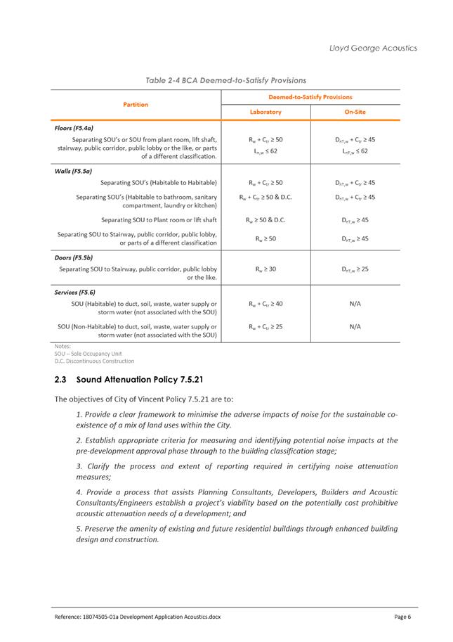
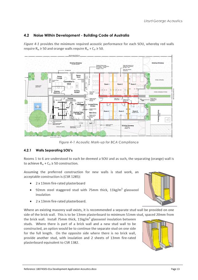
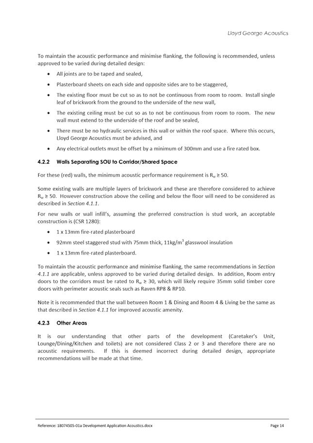
Acoustic Report
The City’s Policy No. 7.5.21 – Sound Attenuation requires applications for lodging houses to be accompanied by an acoustic report. The applicant provided an acoustic report prepared by Lloyd George Acoustics. Following a review of the acoustic report, it was identified that No. 54 Cheriton Street was classified as a commercial premises. This property is a mixed use development comprising a mix of commercial tenancies and residential dwellings. In light of this, a condition is recommended for a revised acoustic report to be provided which correctly classifies the adjoining property to ensure that the proposal achieves compliance with the Environmental Protection (Noise) Regulations 1997.
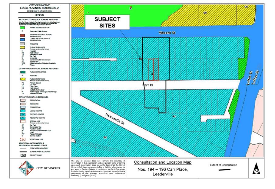
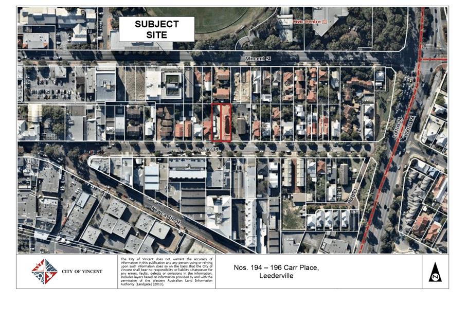
9.3 Nos. 194 - 196 (Lots: 6 & 7; D/P: 1561) Carr Place, Leederville - Proposed Change of Use to Unlisted Use (Unauthorised Existing Development - Site Yard)
TRIM Ref: D19/22501
Author: Fiona Atkins, Urban Planner
Authoriser: Joslin Colli, A/Manager Development & Design
Ward: South
Attachments: 1. Attachment
1 - Consultation and Location Map ⇩ ![]()
2. Attachment 2 -
Development Plans ⇩ ![]()
3. Attachment 3 -
Parking Management Plan ⇩ ![]()
4. Attachment 4 -
Summary of Submissions - Officer's Comments ⇩ ![]()
5. Attachment 5 -
Progress Photograph of Construction at Nos. 269 - 271 Vincent Street
Leederville ⇩ ![]()
6. Attachment 6 -
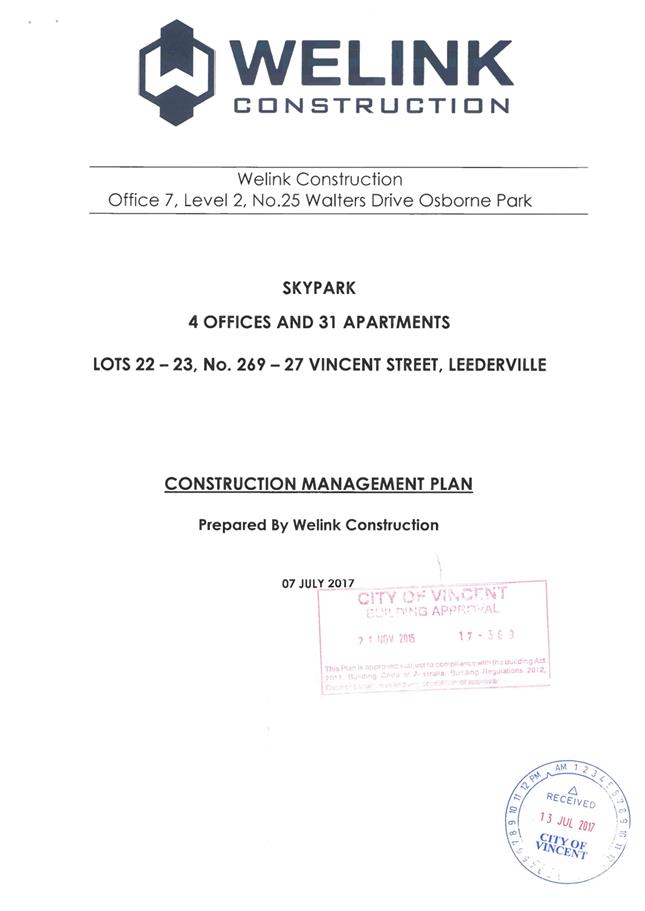
Construction Management Plan (approved 21 November 2017) ⇩ ![]()
7. Attachment 7 -
Determination Advice Notes ⇩ ![]()
|
That Council, in accordance with the provisions of the City of Vincent Local Planning Scheme No. 2 and the Metropolitan Region Scheme, APPROVES the application for the proposed temporary Change of Use to Unlisted Use (Site Yard) at Nos. 194- 196 (Lots: 6 & 7; D/P: 1561) Carr Place, Leederville, in accordance with plans provided in Attachment 2, subject to the following conditions, with the associated determination advice notes in Attachment 7: 1. Use of Premises 1.1 This approval only relates to the Change of Use to Unlisted Use (Site Yard) as shown on the plans dated 28 August 2018. It does not relate to any other development on the site; 1.2 This approval is valid for two years from the date of approval. Following expiry of this period, the development shall not continue unless a further development approval is granted by the City; and 1.3 The Unlisted Use (Site Yard) shall operate in accordance with the Construction Management Plan dated 21 November 2017 (and all subsequent amendments); 2. Car Parking and Access 2.1 The Parking Management Plan shall be updated to include the following: · A maximum of 10 on site parking bays shall be provided; all other staff attending the site are required to park in surrounding public parking bays and required to comply with any applicable restrictions; 2.2 The approved Parking management Plan shall be implemented to the satisfaction of the City and maintained thereafter during the use of the site; and 3. Signage Any new signage that does not comply with the City’s Policy No. 7.5.2 – Signs and Advertising shall be subject to a separate Planning Application and all signage shall be subject to a Building Permit application, being submitted and approved prior to the erection of the signage. |
Purpose of Report:
To consider an application for development approval for a change of use to a temporary unlisted use (site yard) that is currently operating as unauthorised development at Nos. 194 – 196 Carr Place, Leederville.
PROPOSAL:
The application seeks approval for the unauthorised existing use of the subject site as a site yard for the development of multiple dwellings currently underway at Nos. 269 – 271 Vincent Street Leederville. The subject site is located to the south west of Nos. 269 – 271 Vincent Street, as per the location map in Attachment 1.
Background:
|
Landowner: |
Hanrise Pty Ltd |
|
Applicant: |
Welink Construction Pty Ltd |
|
Date of Application: |
28 August 2018 |
|
Zoning: |
MRS: Urban LPS2: Zone: Regional Centre R Code: N/A |
|
Built Form Area: |
Town Centre |
|
Existing Land Use: |
Vacant Land |
|
Proposed Use Class: |
Unlisted Use (Site Yard) |
|
Lot Area: |
1042m2 |
|
Right of Way (ROW): |
No |
|
Heritage List: |
No |
The subject sites are located on Carr Place, between Loftus Street and Oxford Street. The sites are bound by residential properties to the east, west and north. Commercial properties are located directly opposite the site, facing Carr Place from the south.
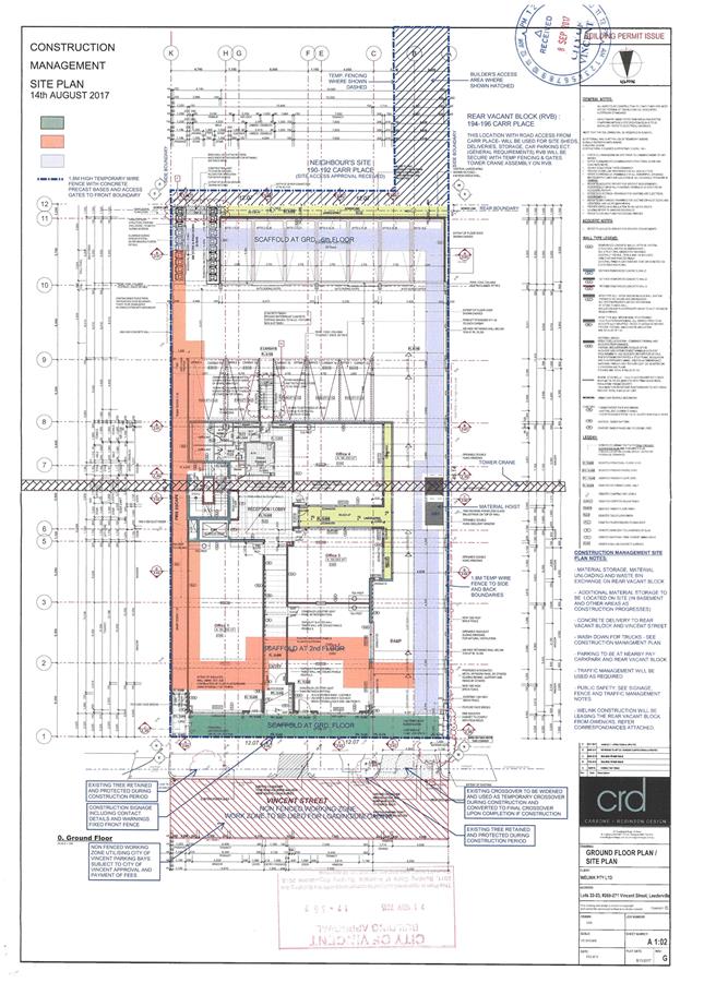
On the 1 April 2015, the Metro West JDAP approved the demolition of existing dwellings and the construction of a six-storey mixed use development at 269-271 Vincent Street. Condition 10.4 of the Development Approval required a Construction Management Plan (CMP) to be submitted to and approved by the City prior to the issue of a Building Permit. The approved CMP is included as Attachment 6.
On 21 November 2017 the City granted the Building Permit for the construction of the abovementioned development. The CMP site plan references the ‘rear vacant block’ at Nos. 194 – 196 Carr Place as being used for deliveries, sheds, storage and car parking with access to the site to be gained through No. 190 Carr Place. This was not noted in the applicable sections of the CMP report.
In December 2017, the City received concerns from two residents regarding development being undertaken at Nos. 194 – 196 Carr Place, as outlined below:
· An e-mail sent to Mayor Cole regarding the implementation of resident only parking in Carr Place. The e-mail mentions a ‘development next to No. 190 Carr Place’ being undertaken.
· A telephone call from a nearby resident concerned with ‘demolition’ occurring at the subject lot.
At this time the applicant, Welink Construction, confirmed that the subject lot was intended to be used for site offices, storage and deliveries and that this was included in the CMP that was submitted and approved as part of the Building Permit for the multiple dwelling development at Nos. 269 – 271 Vincent Street. Prior to the issue of the Building Permit, the CMP was referred to Planning Services for review, however potential non‑compliance with land uses permitted under the Local Planning Scheme was not identified.
On 16 February 2018 the City issued a Building Permit for sheet piling at Nos. 269 – 271 Vincent Street. This application included the previously approved CMP which refers to the use of Nos. 194 – 196 Carr Place to enable the site construction. The City’s Engineering and Ranger services have continued to liaise with the applicant regarding road closures to enable deliveries to be received at Nos. 194 – 196 Carr Place.
Clause 60, Schedule 2 of the Planning and Development (Local Planning Schemes) Regulations 2015 states that a person shall not commence or carry out any works or use of any land or building, unless exempted, without first having applied for and obtained Development Approval.
The City’s Policy No. 7.5.1 – Minor Nature Development states that Development Approval is not required for:
“temporary offices and sheds (including containers) used by builders or contractors directly associated with the building works occurring on site for the duration of completing those building works and operations”.
As the use of Nos. 194 – 196 Carr Place was not included in the Development Approvals for Nos. 269 – 271 Vincent Street, it is not considered to form part of the ‘site’ of the development, and under the City’s Local Planning Scheme No. 2 (LPS2) the use of the site constitutes an “unlisted use”, requiring Development Approval.
If the City were to require the cessation of the use at Nos. 194 – 196 Carr Place, the applicant would not be complying with Condition 10.4 of the Development Approval (Construction Management Plan). On 26 July 2018, the Acting Director of Development Services directed the City’s Administration to request the submission of a retrospective Development Application for the use of Nos. 194 – 196 Carr Place as a site yard the application subject of consideration.
Details:
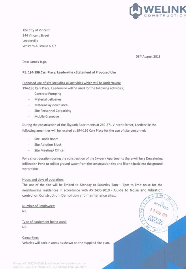
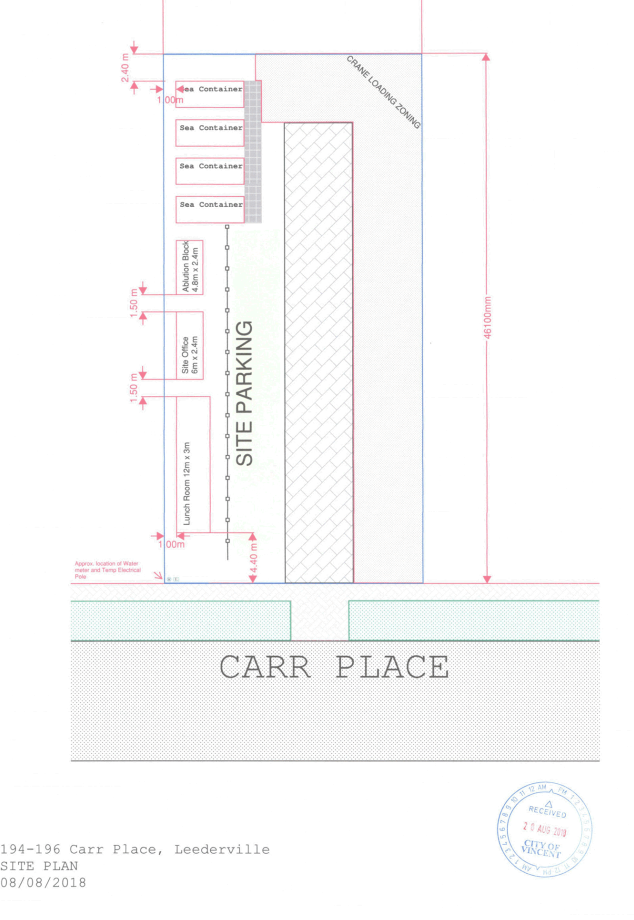
The site yard supports the multiple dwelling development at Nos. 269 – 271 Vincent Street and is managed by Welink Construction. The site yard would be used for site offices, storage and deliveries, staff parking and dewatering equipment.
The applicant has not specified an exact time frame for the use of the site yard, with the intention of the site yard being that it would be available for use for the duration of the construction occurring at Nos. 269 – 271 Vincent Street. The proposed hours and days the site yard would be in use are:
Monday to Saturday: 7:00am to 7:00pm.
The development plans and applicant’s supporting letter are included as Attachment 2.
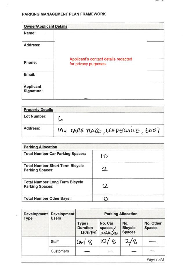
In terms of car parking, as the proposed development is an Unlisted Use, there are no parking requirements outlined in the City’s Policy No 7.7.1 – Non Residential Parking Requirements. Parking requirements are to be determined as per the submitted Parking Management Plan, included as Attachment3.
Summary Assessment
The table below summarises the planning assessment of the proposal against the provisions of the City of Vincent LPS2 and Policy No. 7.7.1 – Non Residential Parking Requirements. In each instance where the proposal requires the discretion of Council, the relevant planning element is discussed in the Detailed Assessment section following from this table.
|
Planning Element |
Use Permissibility/ Deemed-to-Comply |
Requires the Discretion of Council |
|
Land Use |
|
ü |
|
Parking & Access |
|
ü |
|
Bicycle Facilities |
|
ü |
The above elements of the proposal do not meet the specified deemed-to-comply standards and is discussed in the comments section below.
Detailed Assessment
The deemed-to-comply assessment of the element that requires the discretion of Council is as follows:
|
Land Use |
|
|
Deemed-to-Comply Standard |
Proposal |
|
Permissible Use |
Unlisted Use (Site Yard) |
|
Car Parking |
|
|
Policy No. 7.7.1 – Non-Residential Development Parking Requirements Car Bays
Unlisted Uses have no prescribed parking requirement under Table 1 of the Parking Policy, with parking to be determined by the City based on a site specific Parking Management Plan |
10 on-site parking bays provided, as per Parking Management Plan. |
|
Bicycle Parking |
|
|
Policy No. 7.7.1 – Non-Residential Development Parking Requirements
Unlisted Uses have no prescribed bicycle bay requirement under Table 1 of the Parking Policy, with parking to be determined by the City based on a site specific Parking Management Plan. |
2 bicycle bays provided on site, as per Parking Management Plan. |
The above elements of the proposal do not meet the specified deemed-to-comply standards and are discussed in the comments section below.
Consultation/Advertising:
As per the requirements of Policy No. 4.1.5 – Community Consultation, the application was required to be advertised to the surrounding land owners as it is an Unlisted Use. The application was advertised from the 21 January 2019 to 11 February 2019, with the method of consultation being a sign on site, a notice in the local newspaper and 51 letters mailed to surrounding owners and occupiers, the extent of which is shown in Attachment 1.
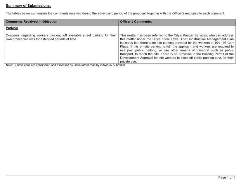
A total of one submission was received, being an expression of concern. The main concern raised within the submission was construction site workers blocking off available street parking for their own private vehicles for extended periods of time.
The Officer’s response to the submission has been included as Attachment 4. The applicant was invited to respond to the submission, no response was received.
Design Review Panel (DRP):
Referred to DRP: No
Legal/Policy:
· Planning and Development Act 2005;
· Planning and Development (Local Planning Schemes) Regulations 2015;
· City of Vincent Local Planning Scheme No. 2;
· Policy No. 4.1.5 – Community Consultation; and
· Policy No. 7.7.1 – Non-Residential Parking Requirements.
Delegation to Determine Applications:
The application is required to be determined by Council as the development proposes a use which is not listed in Table 1 of the City’s Parking Policy.
Risk Management Implications:
There are minimal risks to Council and the City’s business function when Council exercises its discretionary power to determine a planning application.
Strategic Implications:
The City’s Strategic Plan 2013-2023 states:
Innovative and Accountable
We are open and accountable to an engaged community
SUSTAINABILITY IMPLICATIONS:
Nil.
Financial/Budget Implications:
Nil.
Comments:
Land Use
Nos. 194 – 196 Carr Place consists of two abutting lots that are currently being used as an unauthorised construction site yard for the multiple dwelling development in progress at Nos. 296 – 271 Vincent Street. The site yard was approved as part of the Building Permit process, however the site yard was not proposed or approved during the Development Application process.
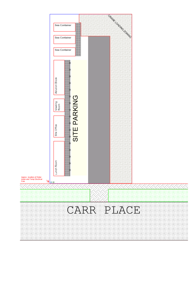
The site yard is currently being used to accommodate the following purposes:
Construction related activities including:
· Concrete pumping;
· Material deliveries;
· Material lay down area;
· Site personnel car parking;
· Mobile craneage;
· Dewatering Infiltration Pond to collect ground water from the site and filter it back to the ground water table.
Amenities for site workers including:
· Site lunch room;
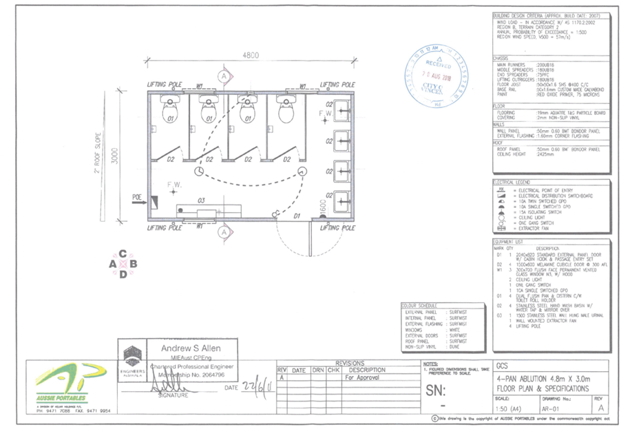
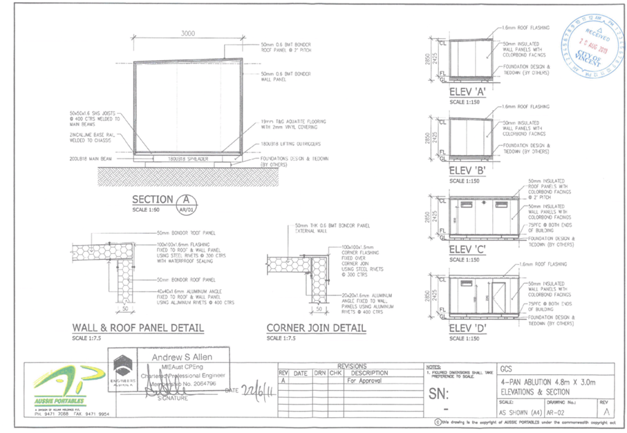
· Site ablution block;
· Site meeting/office.
Prior to the submission of the retrospective Development Application for this site, the City received two complaints regarding development on the site. Neither of the complainants raised specific concerns regarding the use of the property for the purposes of constructing Nos. 269 – 271 Vincent Street, and that the City has not received any further complaints regarding the use of the property
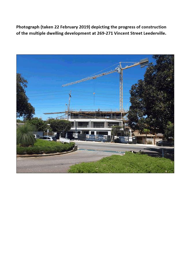
The use of the subject lots as a site yard is to support the construction of multiple dwellings. If the City refused the Development Application for the unauthorised site yard, the applicant would be breaching the requirements of their Construction Management Plan and would be required to cease development. A photograph taken to highlight the progress achieved on site at Nos. 269 – 271 Vincent Street is included as Attachment 5.
The site yard is in keeping with the objectives of the Regional Centre zone, and is appropriate for this context. A time limited two year conditional approval is recommended, to allow the applicant to use the subject lots as site yard until practical completion of the development at Nos. 269 – 271 Vincent Street occurs. It is also recommended that an advice note be added that ties this approval to the development on Nos. 269 – 271 Vincent Street to ensure no subsequent developments in the area seek to use this site for storage purposes.
Car Parking
As the proposal is an Unlisted Use, Policy No. 7.7.1 – Non Residential Parking Requirements does not designate specific requirements for parking. Parking on site is to be determined through the submitted plans and Parking Management Plan. The submitted Parking Management plan is included as Attachment 3. In considering the matter, the following is relevant:
· A maximum of 50 workers are proposed to be on site at any time, with an average of 35 workers on site throughout the construction project;
· The existing site yard provides 10 parking bays on site for site vehicles and construction workers parking;
· The subject site is approximately 350 metres walking distance from a paid parking station off Oxford Street and 450 metres walking distance from a paid parking lot on Vincent Street;
· The site is 600 metres walking distance from Leederville train station;
· There is paid parking along Carr Place, however this has a two hour time limit.
Due to the provision of parking on site and the availability of public parking and public transport in the area, the parking available is adequate to cater for the needs of the site, particularly given the temporary nature of the proposed use.
The comments received from surrounding landowners are specifically regarding issues experienced with workers related to the construction site blocking off public car spaces with witches hats so that they can utilise them for their personal parking. This issue has been reported to the Rangers, and would continue to be addressed by the City’s Rangers through the City’s Local Laws.
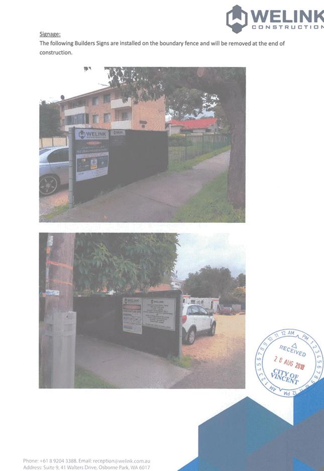
Signage
The applicant has installed construction signage on the fence at the subject site facing Carr Place, providing notification of the construction occurring on site, the applicant’s contact details and other required safety information. This signage is exempt from requiring Development Approval under the City’s Policy No. 7.5.1 – Minor Nature Development, and no further approvals are required for this signage for the duration of the construction.
The proposal requires Council to exercise its discretion in relation to the proposed use of the subject site. The continuation of the Existing Unlisted Use (Site Yard) is appropriate and in accordance with the previously approved Building Permit, and the objectives of the Town Centre Zone of LPS2.
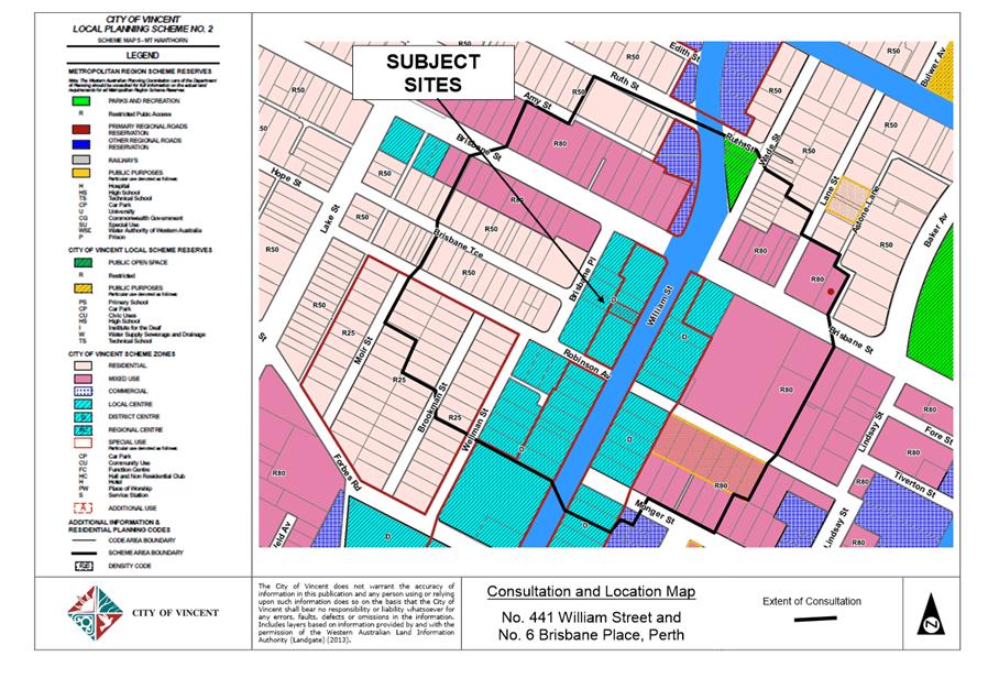
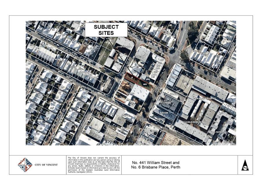
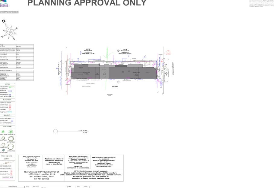
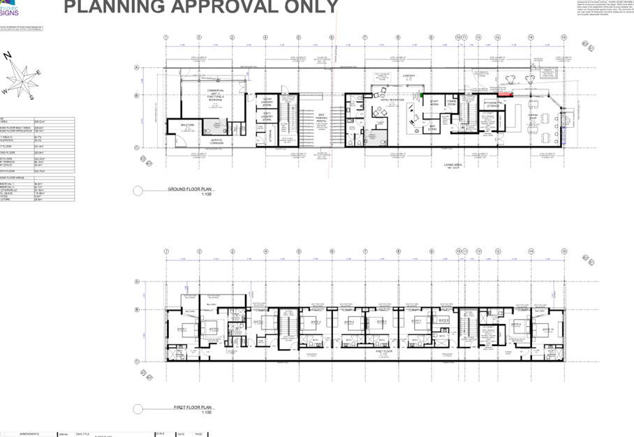
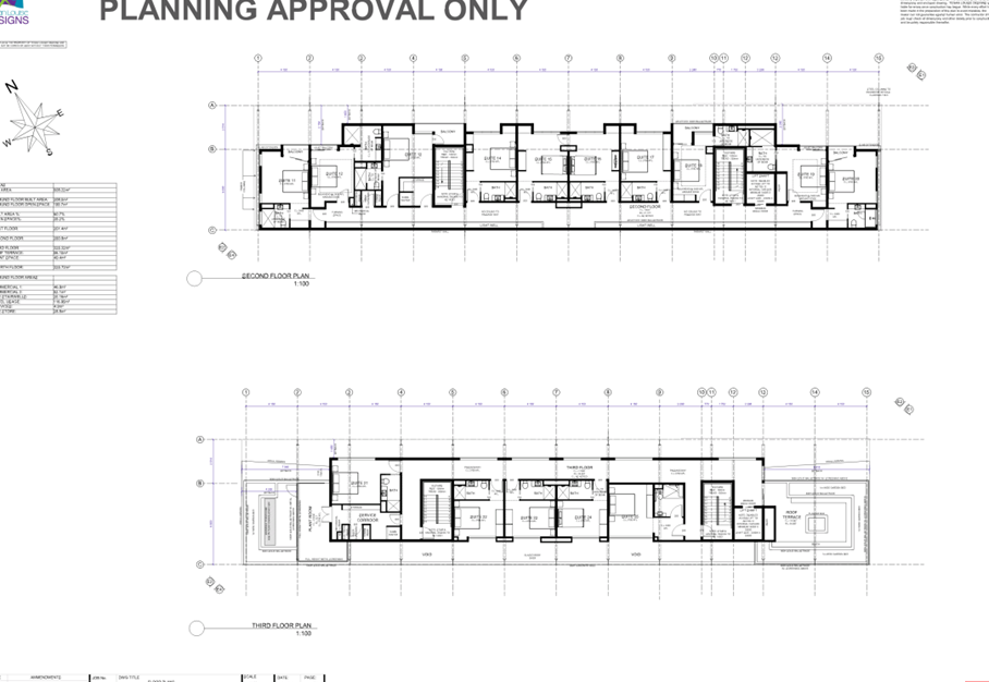
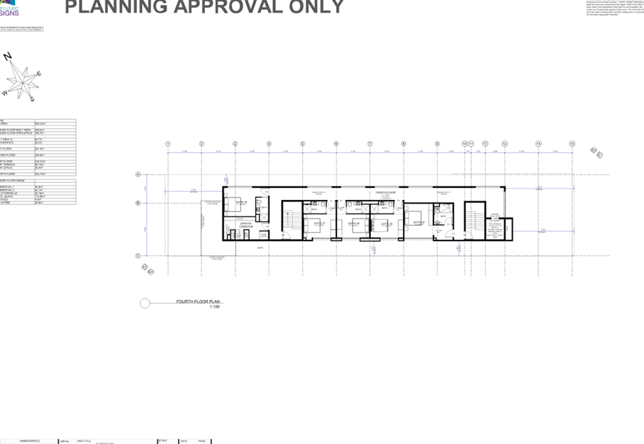
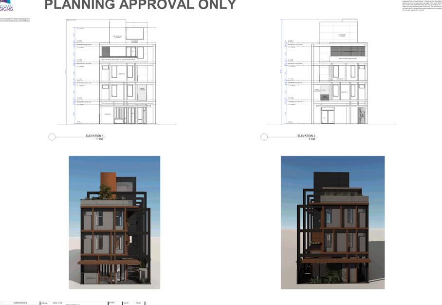
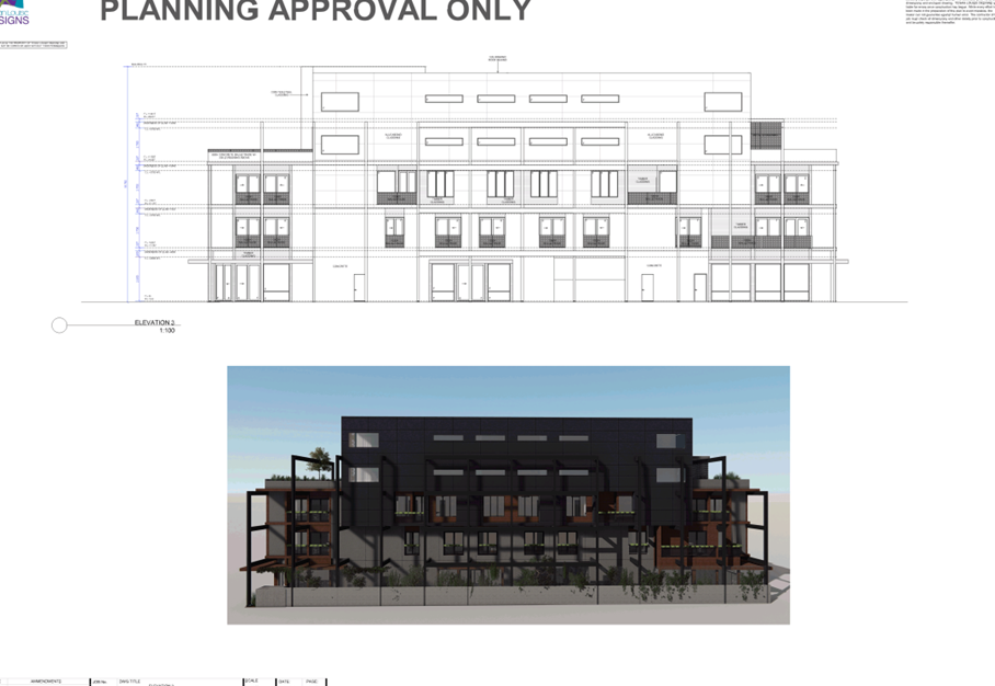
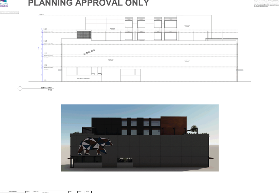
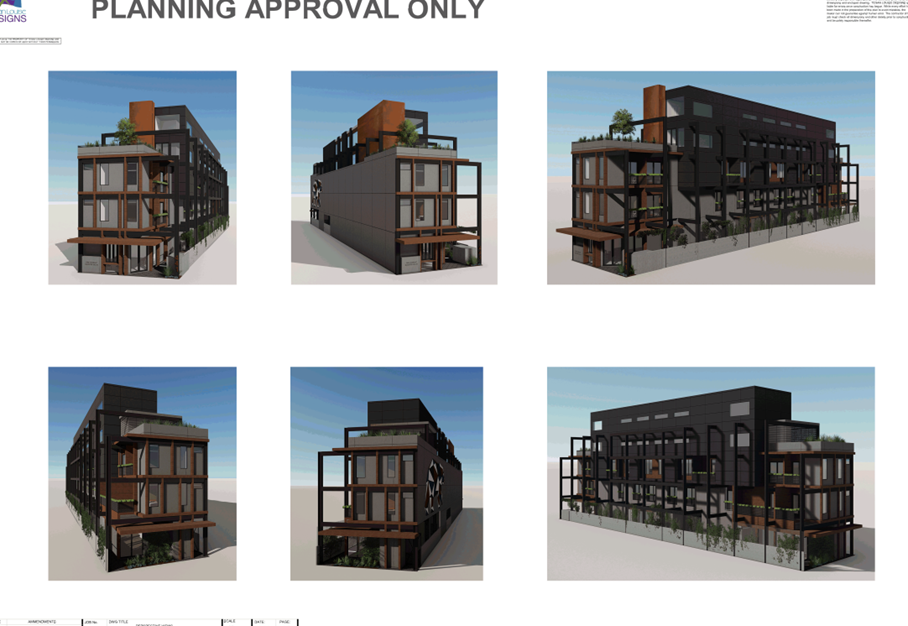
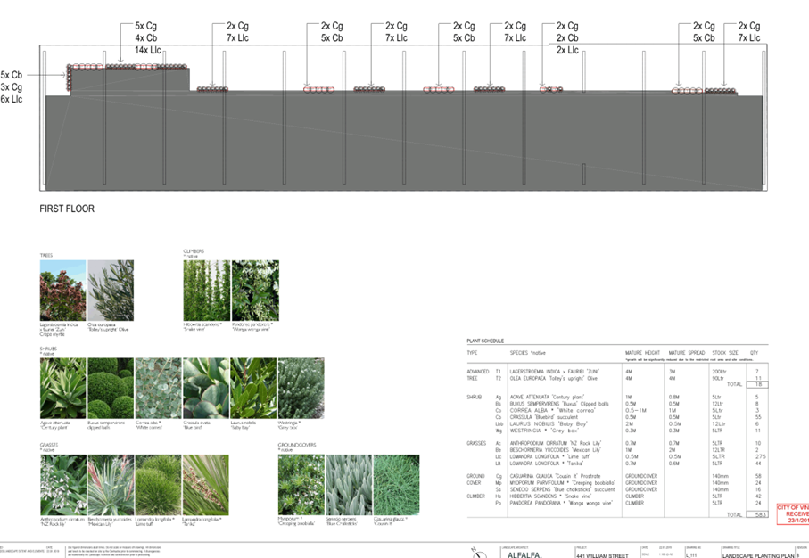
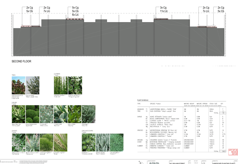
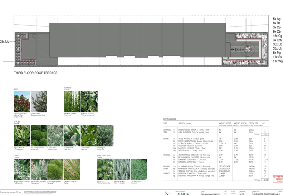
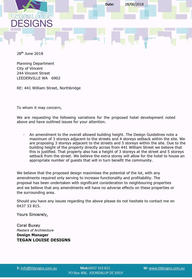
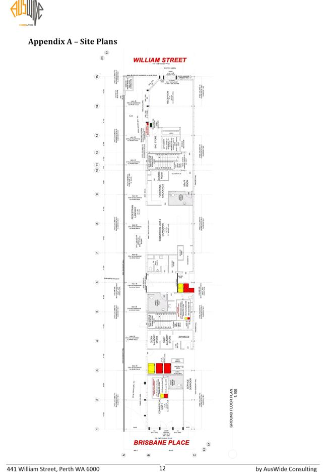
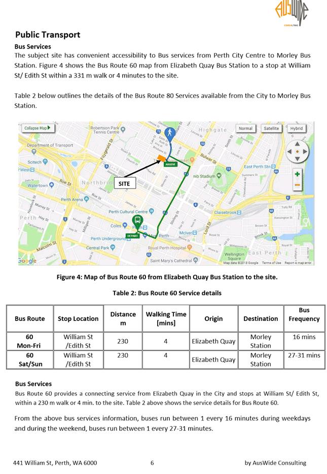
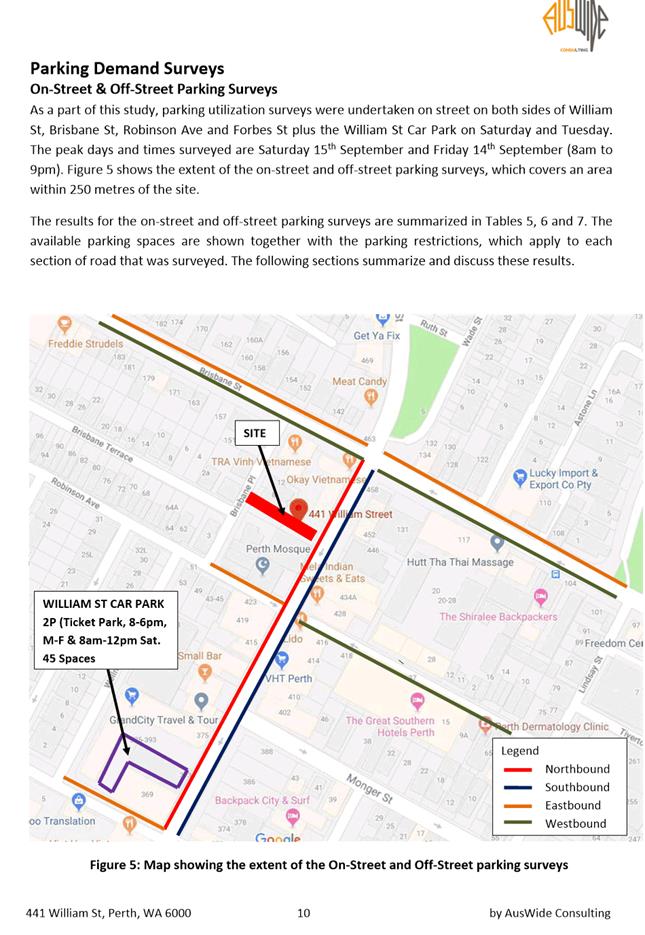
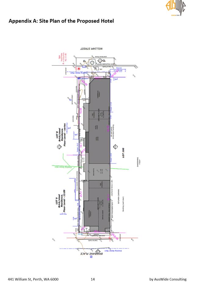
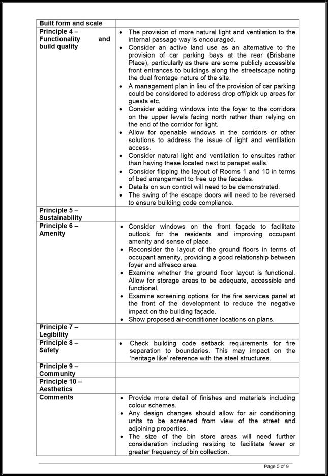
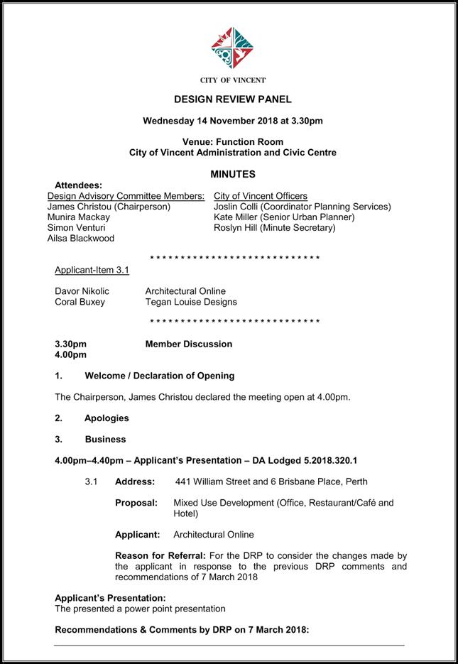
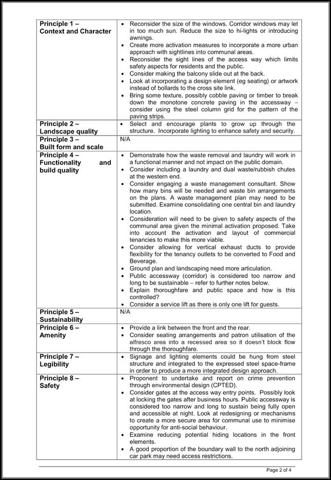
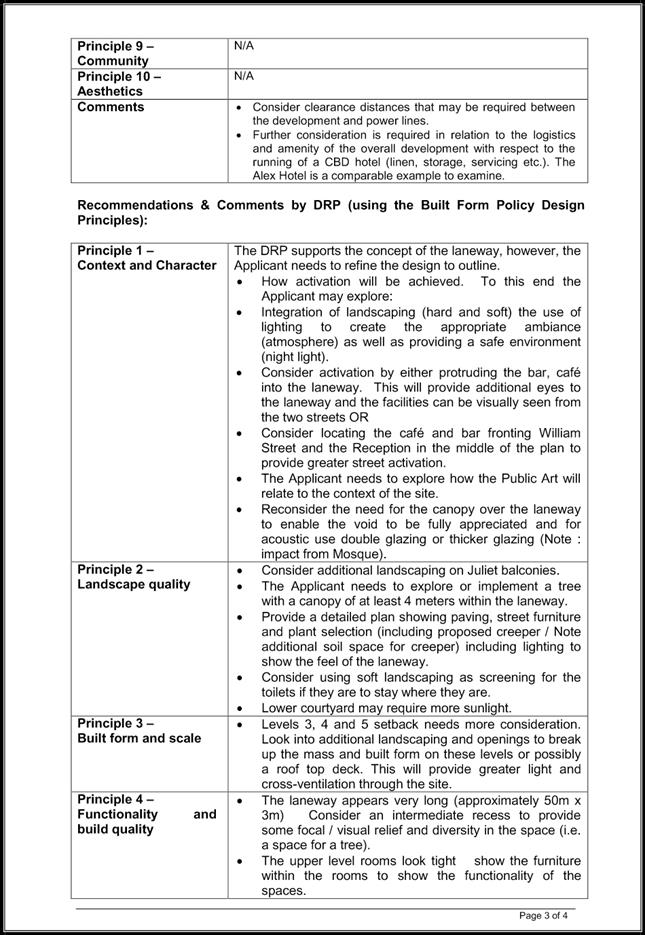
9.4 No. 441 (Lot: 11; D/P: 1114) William Street and No. 6 (Lot: 10; D/P: 1114) Brisbane Place, Perth - Hotel, Restaurant and Office Development
TRIM Ref: D18/191965
Author: Darius Ardeshirian, Senior Urban Planner
Authoriser: John Corbellini, Executive Director Development Services
Ward: South
Attachments: 1. Attachment
1 - Consultation and Location Plan ⇩ ![]()
2. Attachment 2 -
Development Plans ⇩ ![]()
3. Attachment 3 -
Applicant's Report ⇩ ![]()
4. Attachment 4 -
Waste Management Plan ⇩ ![]()
5. Attachment 5 -
Traffic and Parking Demand Assessment ⇩ ![]()
6. Attachment 6 -
Acoustic Report ⇩ ![]()
7. Attachment 7 -
Environmentally Sustainable Design Report ⇩ ![]()
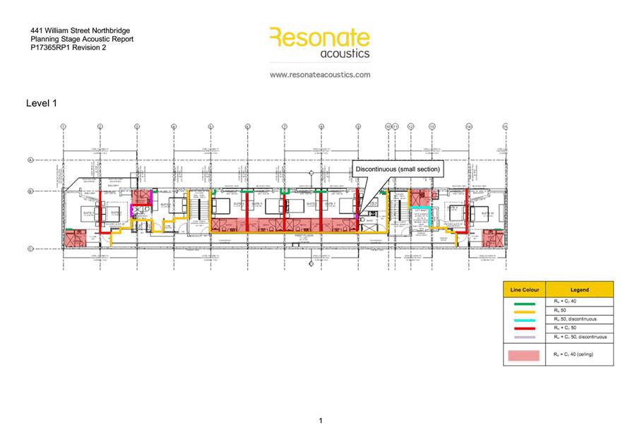
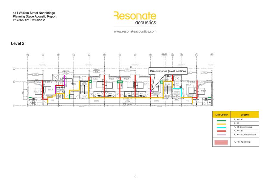
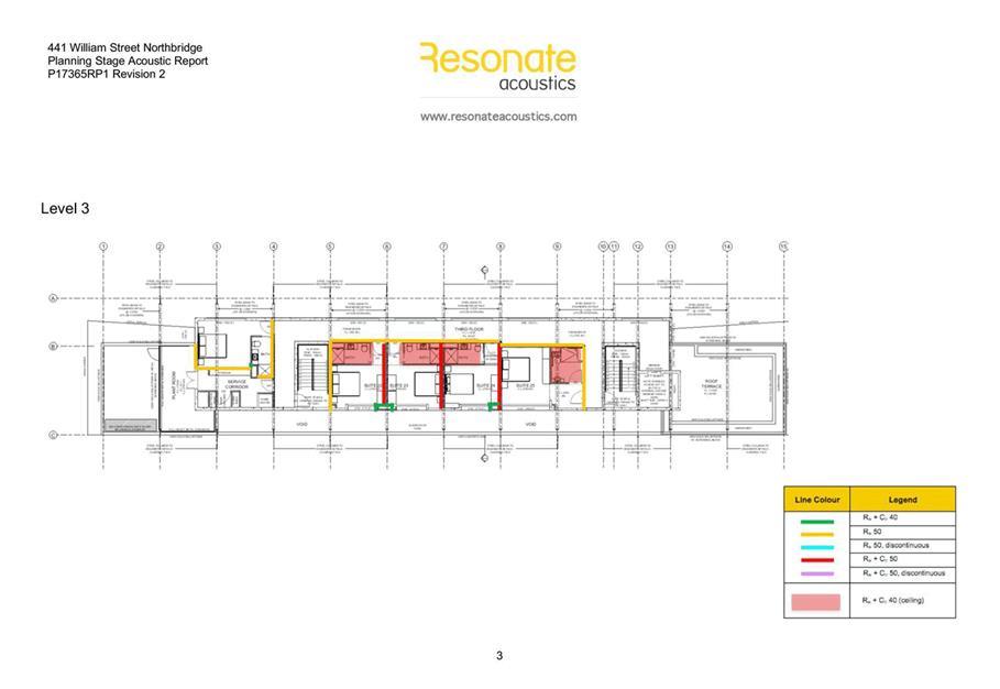
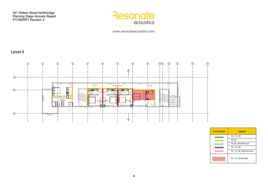
8. Attachment 8 -
Administration's Response to Summary of Submissions ⇩ ![]()
9. Attachment 9 -
Applicant's Response to Submissions ⇩ ![]()
10. Attachment 10 - Design
Review Panel Minutes ⇩ ![]()
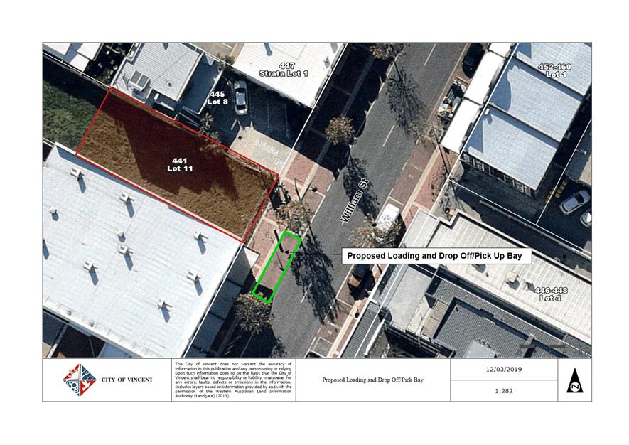
11. Attachment 11 - Loading Bay
Plan ⇩ ![]()
12. Attachment 12 -
Determination Advice Notes ⇩ ![]()
|
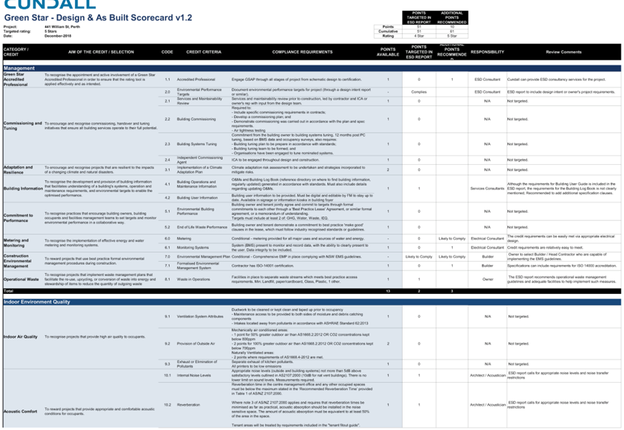
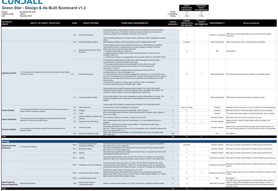
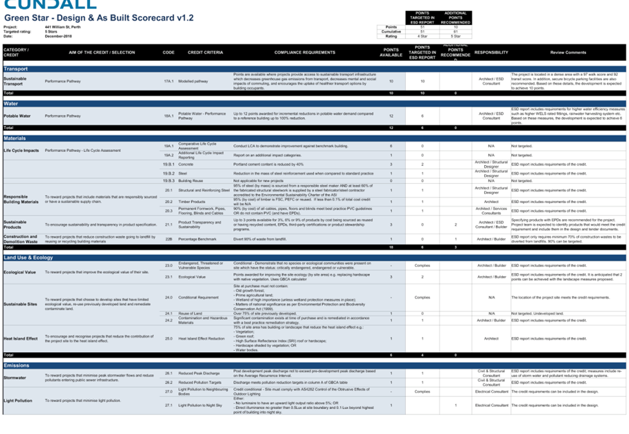
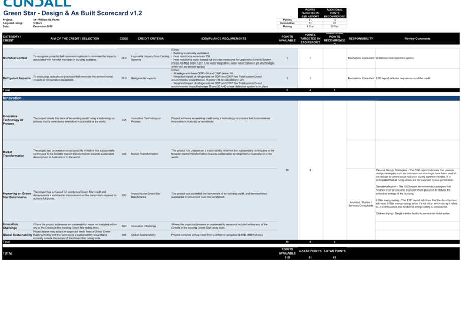
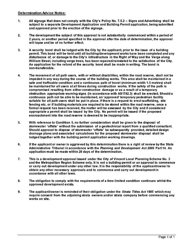
That Council in accordance with the provisions of the City of Vincent Local Planning Scheme No. 2 and the Metropolitan Region Scheme, APPROVES the development application for a Hotel comprising 30 guest rooms, a Restaurant/Café and an Office at No. 441 William Street (Lot: 11; D/P: 1114) Perth in accordance with the plans shown in Attachment 2, subject to the following conditions, with the associated determination advice notes in Attachment 12: 1. This approval is for the Hotel, Restaurant/Café and Office as shown on the approved plans dated 14 December 2018 only and no other development forms part of this approval; 2. Use of the premises: 2.1 The tenancy shown as ‘Coffee Shop’ on the approved plans dated 14 December 2018 is approved for the use of Restaurant/Café as defined in the City of Vincent Local Planning Scheme No.2 and the subject tenancy may not be used for any other use without the prior approval of the City; 2.2 The proposed restaurant/café is limited to a maximum number of 40 customers and 10 staff members at any one time; and 2.3 The tenancy shown as ‘Commercial unit 1’ on the approved plans dated 14 December 2018 is approved for the use of Office as defined in the City of Vincent Local Planning Scheme No.2 and the subject tenancy may not be used for any other use without the prior approval of the City; 3. Cash-in-lieu of parking contributions 3.1 A cash-in-lieu contribution shall be paid to the City for the shortfall of car parking bays of $50,000 prior to the commencement of development or by entering into a written agreement with the City to pay the cash-in-lieu over an agreed period up to five years; and 3.2 Prior to the Occupation of the development the owner(s) or the applicant on behalf of the owner(s) shall comply with the following requirements: 3.2.1 pay a cash-in-lieu contribution of $50,000; OR 3.2.2 lodge an appropriate assurance bond/ bank guarantee of a value of $50,000 to the satisfaction of the City. This assurance bond/bank guarantee would only be released in the following circumstances: 3.2.2.1. to the owner(s)/applicant where the subject ‘Approval to Commence Development’ did not commence and subsequently expired; 4. Loading Bay 4.1 The two existing on-street car bays adjacent to the subject site on William Street are to be used as the Loading Bay and Drop Off/Pick Up Bay for the proposed development; 4.2 Detailed drawings in compliance with the relevant Australian Standards, including swept path analysis of the largest vehicle expected to use the bay, is to be provided to and approved by the City prior to submission of a Building Permit; and 4.3 All costs associated with the establishment of the bay, including line marking and modifications to the public infrastructure, are the responsibility of the Applicant; 5. Parking Management Plan 5.1 Prior to the occupation of the development a Parking Management Plan shall be submitted to and approved by the City. The Parking Management Plan is to include, but not limited to, addressing the following: · Detailed management measures for the use and operation of the loading bay/drop off and pick up bay, to ensure access is readily available for service vehicles and guests of the hotel at all times; and · Detailed management measures for Hotel staff and guests relating to availability of parking within the area; and 5.2 The Parking Management Plan as identified in Condition 5.1 above shall be implemented, and the development shall be carried out in accordance with the approved Parking Management Plan and approved plans, to the satisfaction of the City at the expense of the owners/occupiers; 6. Service Management Plan 6.1 A detailed loading bay management plan, to the satisfaction of the City, shall be lodged with and approved by the City prior to the commencement of development; and 6.2 The approved loading bay management plan shall be implemented and maintained to the satisfaction of the City of Vincent; 7. Boundary Walls The owners of the subject land shall finish and maintain the surface of the boundary walls in a good and clean condition prior to the occupation or use of the development and thereafter to the satisfaction of the City; 8. Schedule of External Finishes Prior to the commencement of development a detailed schedule of external finishes (including materials and colour schemes and details) shall be submitted to and approved by the City. The development shall be finished in accordance with the approved schedule prior to the use or occupation of the development; 9. Stormwater All stormwater produced on the subject land shall be retained on site, by suitable means to the full satisfaction of the City; 10. Waste Management Plan 10.1 A Waste Management Plan must be submitted to and approved by the Local Government prior to lodging an application for a building permit. The plan must include the following details to the satisfaction and specification of the Local Government: 10.1.1 the location of bin storage areas and bin collection areas; 10.1.2 the number, volume and type of bins, and the type of waste to be placed in the bins; 10.1.3 details on the future ongoing management of the bins and the bin storage areas, including cleaning, rotation and moving bins to and from the bin collection areas; and 10.1.4 frequency of bin collections; 10.2 The approved Waste Management Plan must be implemented at all times to the satisfaction of the Local Government unless otherwise approved; 11. Bicycle Parking 11.1 A minimum of 10 bicycle bays are to be provided and installed in accordance with AS2890.3 prior to the occupation or use of the development; and 11.2 Plans demonstrating the provision of two end of trip facilities are to be provided to and approved by the City prior to submission of a building permit; 12. Construction Management Plan A Construction Management Plan that details how the construction of the development would be managed to minimise the impact on the surrounding area shall be lodged with and approved by the City prior to the commencement of the development. The Construction Management Plan is required to address the following concerns that relate to any works to take place on the site: · Public safety, amenity and site security; · Contact details of essential site personnel; · Construction operating hours; · Noise control and vibration management; · Dilapidation Reports of nearby properties; · Air, sand and dust management; · Stormwater and sediment control; · Soil excavation method; · Waste management and materials re-use; · Traffic and access management; · Parking arrangements for contractors and subcontractors; · Consultation plan with nearby properties; and · Compliance with AS4970-2009 relating to the protection of trees on the development site; 13. Environmentally Sustainable Design The building is to be constructed in accordance with the requirements of the ESD report prepared by Cundall dated 13 December 2018 to satisfy the design principles of Clause 1.8 Policy No. 7.1.1 – Built Form Policy; 14. Public Art 14.1 Percent for public art contribution of $45,000 being one percent of the total $4.5 million value of the development shall be allocated towards public art prior to the commencement of the development; 14.2 Confirmation in writing outlining how the proposed development would comply with the City of Vincent Policy No. 7.5.13 – Percent for Art shall be submitted prior to commencement of development; and 14.3 Public art shall be approved by the City and fully installed or alternatively a cash-in-lieu payment made prior to occupation of the development; and 15. Landscape and Reticulation Plan 15.1 A detailed landscape and reticulation plan for the development site, to the satisfaction of the City, shall be lodged with and approved by the City prior to lodgement of a Building Permit. The plan shall be drawn to a scale of 1:100 and show the following: · The location and type of existing and proposed trees and plants; · Areas to be irrigated or reticulated; · The provision of a minimum of 9.5 percent deep soil area, as defined by the City’s Policy No. 7.1.1 – Built Form; and · The provision of trees contributing towards canopy coverage within deep soil areas provided and within the front setback area. The tree species are to be in accordance with the City’s recommended tree species list; and 15.2 All works shown in the plans as identified in the condition above shall be undertaken in accordance with the approved plans to the City’s satisfaction, prior to occupancy or use of the development and maintained thereafter to the satisfaction of the City at the expense of the owners/occupiers. |
Purpose of Report:
To consider an application for development approval for a Five Storey Mixed Use Development comprising a Hotel with 30 guest rooms, a Restaurant/Café and an Office at No. 441 William Street and No. 6 Brisbane Place, Perth (the subject site).
Background:
|
Landowner: |
Xiuyi Guo and Shuya Duan |
|
Applicant: |
Architectural Online |
|
Date of Application: |
22 August 2018 (amended plans submitted 14/12/18 and 23/1/19) |
|
Zoning: |
MRS: Urban LPS2: Zone: District Centre R Code: N/A |
|
Built Form Area: |
Town Centre |
|
Existing Land Use: |
Vacant Site |
|
Proposed Use Class: |
Mixed Use Development (Hotel, Restaurant/Café and Office) |
|
Lot Area: |
506m² |
|
Right of Way (ROW): |
N/A |
|
Heritage List: |
N/A |
The subject site is zoned District Centre under the City’s Local Planning Scheme No. 2 (LPS2). No. 6 Brisbane Place is located within the Town Centre Area in Policy No. 7.1.1. – Built Form (Built Form Policy) and No. 441 William Street is located within the Design Guidelines for William Street Design, Between Bulwer and Newcastle Streets, Perth (William Street Design Guidelines).
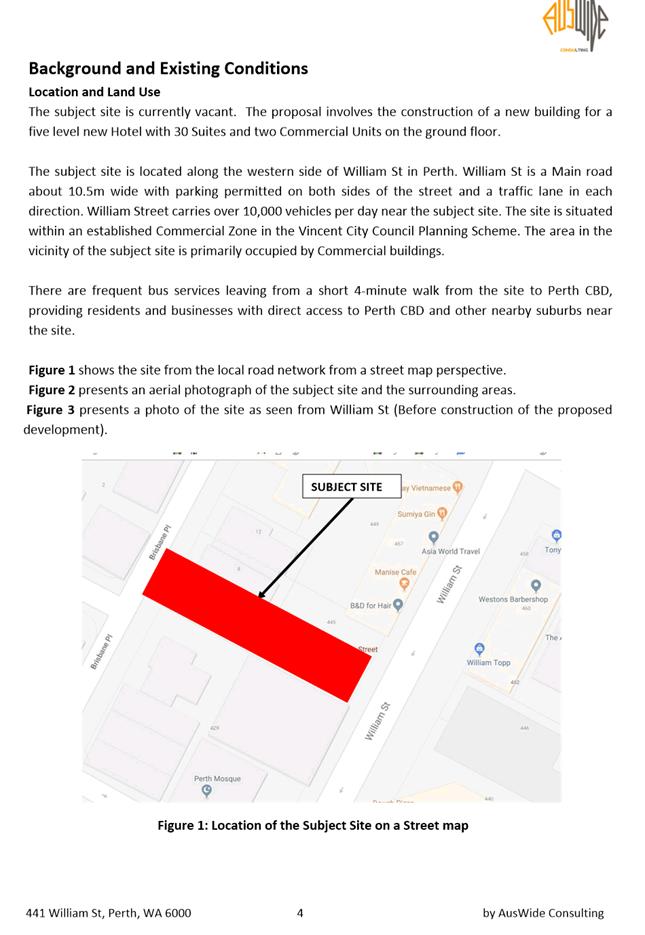
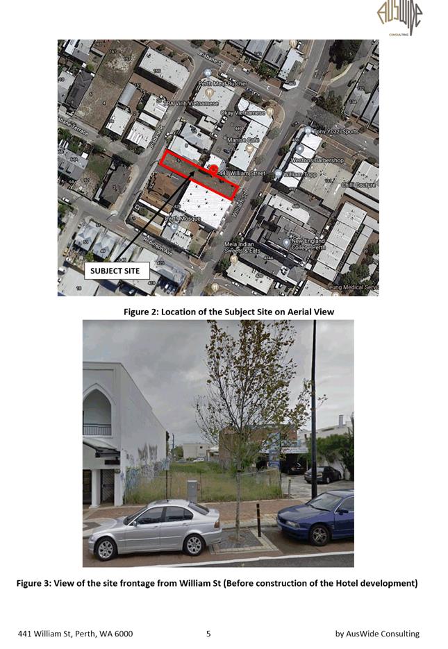
The site is currently vacant and is bound by William Street to the east, Brisbane Place to the west, grouped dwellings and a commercial premises to the north and grouped dwellings and a place of worship to the south. The opposite side of William Street comprises commercial development. This area is zoned District Centre under the City’s LPS2 and forms part of the Town Centre Built Form area. The opposite side of Brisbane Place comprises grouped and multiple dwellings, is zoned Residential R50 under the City’s LPS2 and forms part of the Residential Built Form area. A location plan is included as Attachment 1.
Details:
The application proposes a Five Storey Mixed Use Development comprising a Hotel with 30 guest rooms, a Restaurant/Café and a bicycle rental shop, which is ancillary to the Hotel. An Office is also proposed which is separate to the Hotel. No vehicle parking is proposed on site.
The Restaurant/Café is located adjacent to William Street and the Office is located adjacent to Brisbane Place. The reception area for the hotel is located in the centre of the building on the ground level and is accessed via a private pedestrian access way which is be accessed via both street entrances. The access way is intended to accommodate an additional outdoor seating area for the Hotel and the Restaurant/Café and proposes gates that would be closed at night time for security purposes.
The Hotel proposes to accommodate a maximum of 60 guests, who would be serviced 24 hours a day, 7 days a week by a maximum of 15 staff at any one time. The Office is proposed to operate from 9:00am to 5:00pm, Monday to Friday and would accommodate a maximum of three staff at any one time.
Summary Assessment
The table below summarises the planning assessment of the proposal against the provisions of the City of Vincent Local Planning Scheme No. 2 (LPS2), the City’s Policy No. 7.1.1 – Built Form, the William Street Design Guidelines and the City’s Policy No. 7.7.1 – Non-Residential Parking. In each instance where the proposal requires the discretion of Council, the relevant planning element is discussed in the Detailed Assessment section following from this table.
|
Planning Element |
Use Permissibility/ Deemed-to-Comply |
Requires the Discretion of Council |
|
Land Use |
|
ü |
|
Street Setback |
ü |
|
|
Building Setbacks/Boundary Wall |
|
ü |
|
Building Height/Storeys |
|
ü |
|
Landscaping |
|
ü |
|
Parking & Access |
|
ü |
|
Bicycle Facilities |
ü |
|
|
Essential Facilities |
ü |
|
|
External Fixtures |
ü |
|
|
Surveillance |
ü |
|
|
Outbuildings |
ü |
|
|
Ground Floor Design |
ü |
|
|
Awnings, Verandahs and Collonades |
|
ü |
|
Building Design |
ü |
|
|
Environmentally Sustainable Design |
ü |
|
Detailed Assessment
The deemed-to-comply assessment of the elements that requires the discretion of Council are as follows:
|
Land Use |
|
|
Deemed-to-Comply Standard |
Proposal |
|
Local Planning Scheme No. 2
‘P’ use
Clause 32(1) of LPS2 states that an Office land use is not permitted on the ground floor or at grade level with the street within the Regional Centre zone. |
Hotel: ‘A’ Office: ‘D’ |
|
Building Height |
|
|
Deemed-to-Comply Standard |
Proposal |
|
William Street Design Guidelines – Height and Massing
Three storeys adjacent to the Primary Street
Built Form Policy Clause 1.1 – Building Height
Maximum six storeys |
The proposed development is five storeys. |
|
Lot Boundary Setbacks |
|
|
Deemed-to-Comply Standard |
Proposal |
|
William Street Design Guidelines – Height and Massing
Buildings are to have nil setbacks to the front, side and rear boundaries, with interfaces and facades to William Street being interconnected with the streetscape. |
Northern Boundary First storey: Nil to 3.1 metres Second storey: Nil to 3.1 metres Third storey: Nil to 1.5 metres Fourth storey: Nil to 1.5 metres Fifth storey: 1.5 metres
|
|
Built Form Policy Clause 1.2 – Setbacks
Minimum side boundary setbacks for the first two storeys is nil.
The Third storey and above requires a minimum setback of 4 metres. |
Southern Boundary Third storey: Nil to 1.9 metres Fourth storey: 1.9 metres Fifth storey: 1.8 metres |
|
Awnings |
|
|
Deemed-to-Comply Standard |
Proposal |
|
William Street Design Guidelines – Awnings
Awnings are to be provided over the footpath for the entire length of William Street to provide pedestrians with weather protection. |
An awning is provided for 83 percent of the lot frontage. |
|
Tenancy Size |
|
|
Deemed-to-Comply Standard |
Proposal |
|
Built Form Policy Clause 1.4 Tenancy Size
Ground floor spaces with a width between 7.5m to 9m |
Restaurant/Café: 6.5 metres Office: 4.9 metres |
|
Vehicle Parking |
|
|
Deemed-to-Comply Standard |
Proposal |
|
Non-Residential Development Parking Requirements Policy
Hotel: 24 vehicle bays Restaurant/ Café: 7.5 vehicle bays Office: 0.54 vehicle bays
Total vehicle bays required: 32
Motorcycle /Scooter Bays: 1.6 bays (rounds to 2) |
Nil vehicle bays would be provided on site
Nil motorcycle/scooter bays would be provided on site |
|
Landscaping |
|
|
Deemed-to-Comply Standard |
Proposal |
|
Built Form Policy Clause 1.7 Landscaping
15 percent of the site is to be provided as deep soil zones, being a minimum space of 1 metre.
80 percent of the rear or side setback area is to be provided as canopy coverage at maturity |
9.5 percent of the site area is provided as deep soil zones
Nil percent of the rear or side setback area is provided as canopy coverage at maturity |
The above element of the proposal do not meet the specified deemed-to-comply standards and are discussed in the comments section below.
Consultation/Advertising:
Public Consultation
Community consultation was undertaken for a period of 21 days in accordance with the Planning and Development (Local Planning Scheme) Regulations 2015, from 7 November 2018 to 27 November 2018. The method of advertising included 453 letters being mailed to all owners and occupiers within 150 metres of the site, a sign being erected on-site, a newspaper advertisement and a notice on the City’s website in accordance with the City’s Policy No. 4.1.5 – Community Consultation.
During the consultation period, a total of 12 submissions were received, being three supporting the proposal, three objecting to the proposal and six neither supporting nor objecting to the proposal. The main concern raised within the submissions received related to the following matters:
· Lack of parking;
· Congestion caused by service vehicles;
· Noise;
· Lack of landscaping; and
· Waste.
A summary of the submissions with Administration’s and the applicant’s response is provided within Attachment 8 and Attachment 9, respectively.
Design Review Panel (DRP):
Referred to DRP: Yes
The proposed development was presented to the DRP on 17 January 2018, 7 March 2018, and 14 November 2018. The comments made by the DRP is summarised as follows:
· The DRP supported the concept of the laneway and suggested amendments to ensure activation is achieved and landscaping and lighting is incorporated to create the appropriate ambiance (atmosphere) as well as providing a safe environment (night light);
· Consider activation by protruding the bar/café into the laneway to provide surveillance of the spaces, or locate the café/bar fronting William Street and the Reception in the middle of the plan;
· Consider planting significant trees within the laneway and landscaping on the Juliet balconies;
· Levels 3, 4 and 5 setback needs more consideration. Look into additional landscaping and openings to break up the mass and built form on these levels or possibly a roof top deck. This would provide greater light and cross-ventilation through the site;
· Look at the possibility of a service lift as the traffic may be too great. Obtaining advice and input from a boutique hotel operator would help in this regard;
· Functional aspects need to be worked on and finalised (i.e. bins, patron drop off, laundry); and
· The project has significant potential but requires further development. An integrated and considered combination of high quality soft landscaping, public art, lighting and streetscape activation strategies need to be applied to the laneway area to ensure the success of this area.
The DRP’s comments on the proposal is included within Attachment 10.
Legal/Policy:
· Planning and Development Act 2005;
· Planning and Development (Local Planning Schemes) Regulations 2015;
· City of Vincent Local Planning Scheme No. 2;
· Policy No. 4.1.5 – Community Consultation;
· Policy No. 7.1.1 – Built Form Policy;
· Policy No. 7.5.13 – Percent for Public Art;
· Policy No. 7.5.21 – Sound Attenuation;
· Policy No. 7.5.23 – Construction Management Plans;
· Policy No. 7.7.1 – Non-Residential Development Parking Requirements; and
· Appendix No. 18 – Design Guidelines for William Street, Between Bulwer and Newcastle Streets, Perth.
Risk Management Implications:
There is minimal risks to Council and the City’s business function when Council exercises its discretionary power to determine a planning application.
Strategic Implications:
This is in keeping with the City’s Strategic Community Plan 2018-2028:
“Innovative and Accountable
We are open and accountable to an engaged community”.
SUSTAINABILITY IMPLICATIONS:
Nil.
Financial/Budget Implications:
Nil.
Comments:
Local Planning Scheme No. 2
Clause 32(1) of LPS2 states that an Office land use is not permitted on the ground floor or at grade level with the street within the District Centre zone. Notwithstanding this, an Office use is capable of being approved in accordance with Clause 34(2) of LPS2 provided that the City is satisfied that the proposal satisfies the following criteria of Clause 34(5):
(a) approval of the proposed development would be appropriate having regard to the matters that the local government is to have regard to in considering an application for development approval as set out in clause 67 of the deemed provisions; and
(b) the non-compliance with the additional site and development requirement will not have a significant adverse effect on the occupiers or users of the development, the inhabitants of the locality or the likely future development of the locality.
With regard to a) above, the proposed Office use is appropriate having regard to the matters to be considered by local government set out in Clause 67 of the Planning and Development (Local Planning Schemes) Regulations 2015 deemed provisions for the following reasons:
· The subject site and surrounding properties along William Street are zoned District Centre under the City’s LPS2 and comprise commercial development. The proposed development satisfies the objectives of the District Centre Zone as the land uses would be compatible and consistent with the surrounding context. The land uses add an additional service to the locality and provide additional opportunities for employment. The surrounding businesses may also benefit from the increase in density created by the hotel occupants.
· The Office proposes its primary access from Brisbane Place and pedestrian access via William Street. Office land uses are less intensive then other land uses capable of consideration in this location and the office is appropriately located opposite the residential development on the opposite side of Brisbane Place.
· The proposal meets the objectives of the City’s Parking Policy and is unlikely to generate traffic that exceeds the capacity of the existing road system in the locality, as discussed in further detail below.
Land Use
The applicant seeks approval for a Hotel which is an ‘A’ use, a Restaurant/Café which is a ‘P’ use and an Office which is a ‘D’ use within the District Centre Zone, as prescribed by LPS2.
The objectives of the District Centre zone are as follows:
· To provide a community focus point for people, services, employment and leisure that are highly accessible and do not expand into or adversely impact on adjoining residential areas;
· To encourage high quality, pedestrian-friendly, street-orientated development that responds to and enhances the key elements of each District Centre, and to develop areas for public interaction.
· To ensure levels of activity, accessibility and diversity of uses and density is sufficient to sustain public transport and enable casual surveillance of public spaces;
· To ensure development design incorporates sustainability principles, with particular regard to waste management and recycling and including but not limited to solar passive design, energy efficiency and water conservation;
· To ensure the provision of a wide range of different types of residential accommodation, including affordable, social and special needs, high density residential and tourist accommodation, to meet the diverse needs of the community;
· To provide a broad range of employment opportunities to encourage diversity and self-sufficiency within the Centre;
· To encourage the retention and promotion of uses including but not limited to specialty shopping, restaurants, cafes and entertainment; and
· To ensure that the City’s District Centres are developed with due regard to State Planning Policy 4.2 – Activity Centres for Perth and Peel.
The application proposes a boutique sized hotel, which adds diversity to the existing land uses within the locality. The hotel would be compatible with the existing food and beverage premises along William Street. The area benefits from close proximity to public transport, food and beverage options and late night bars and restaurants. The added inclusion of bikes for hotel guests would increase the accessibility to these offerings.
The Restaurant/Café located adjacent to William Street could service the Hotel guests whilst also benefiting the wider community. The design of the development also incorporates a pedestrian access way and additional seating area, which may provide opportunity for further activation of the street.
The land uses would satisfy the objectives of the zone and is acceptable.
Building Height
The William Street Design Guidelines prescribes a maximum building height of three storeys when development is adjacent to the primary street and up to four storeys within the site. The Built Form Policy permits a maximum of six storeys.
The application proposes a maximum of five storeys over both sites. The first three storeys propose a nil setback to the William Street boundary. The fourth and the fifth storey propose a 7.5 metre setback from the William Street boundary.
The William Street Design Guidelines stipulate the fourth storey of all development is to be setback a minimum of 5 metres from the William Street boundary. The William Street Design Guidelines require consideration of the maximum building height along William Street in view of the unique topography and uninterrupted vista to the Perth Central Business District (CBD).
In considering the above, the following is relevant:
· The development situated on No. 6 Brisbane Place satisfies the deemed to comply height requirements prescribed by the Built Form Policy;
· The application proposes a large setback from the William Street boundary, which moderates the impacts of building bulk and mass on the streetscape. The setbacks also ensure views along William Street, towards Perth CBD would be maintained;
· The northern property adjacent to No. 441 William Street comprises a two storey building with a large setback from William Street to allow for vehicle access and parking. As this building is not consistent with the intent of the William Street Design Guidelines, redevelopment is encouraged. The subject application proposes the building to be setback from the northern boundary, which would ameliorate impacts of building bulk and mass as viewed from the adjoining property and the street;
· The southern property adjacent to No. 441 William Street comprises a two storey building built up to the boundary. The proposed development would have no impact on the amenity of the adjoining occupants;
· Amendments to the William Street Design Guidelines were recently advertised in accordance with the City’s Consultation Policy. The amendments propose to increase the maximum heights from three storeys to four storeys where adjacent to William Street and four storeys to five storeys where the development is setback from the William Street boundary. In accordance with Clause 67 of the deemed provisions of the Planning and Development (Local Planning Schemes) Regulations 2015, this amendment is considered seriously entertained and the decision maker is required to have Due Regards when considering the application. The proposed development is consistent with the proposed amendment, which is to be presented to Council at an upcoming Ordinary Council Meeting.
For the above reasons, the proposed building height is acceptable.
Lot Boundary Setbacks
The William Street Design Guidelines require buildings to have a nil setback to the side lot boundaries. The Built Form Policy permits nil setbacks for the first two storeys. A three metre setback is required thereafter.
The proposed development was advertised to adjoining properties in accordance with the City’s Consultation Policy. No submissions raised any concerns in relation to lot boundary setbacks.
Northern boundary
The development proposes 13 evenly spaces beams on the first four levels with a nil setback to the northern lot boundary. The remainder of the building is setback between 1.4 metres to 3.5 metres on all levels.
The proposed setbacks from the northern boundary ensures the pedestrian access way and guest rooms would be provided with access to natural sunlight and ventilation. The beams would not be imposing on the streetscape or adjoining properties or cause impacts of building bulk or mass. The bulk and scale of the building is further moderated by the setback of the first two storeys, which creates a pedestrian access way. This setback provides opportunity for landscaping and activation on the site.
The northern boundary setbacks are acceptable.
Southern boundary
The southern elevation of the development proposes nil setback to the first three storeys, and a 1.9 metre and 1.8 metre setback to the fourth and fifth storeys, respectively.
The adjoining property comprises a place of worship adjacent to William Street and grouped dwellings adjacent to Brisbane Place. The place of worship is a two storey building built up to the shared lot boundary. The grouped dwellings are two storey development which are setback 4.8 metres from the shared lot boundary to allow for vehicle access. A car parking area separates the place of worship from the grouped dwellings.
The application proposes the fourth and fifth storeys of the building to be setback 7.5 metres from William Street and 7 metres from Brisbane Place which would assist in moderating the impacts of building bulk and mass on adjoining properties and the streetscapes. The southern elevation of the fourth and fifth storeys also contain large openings to increase the glazing aspect of the development and reduce portions of blank solid walls. The application incorporates design elements such as contrasting colours and materials and landscaping on the upper floors to assist in further moderating the impact of building bulk.
The southern boundary setbacks are acceptable.
Awnings
The William Street Design Guidelines requires continuous awnings for the entire length of William Street to provide pedestrians with weather protection.
The application proposes an awning over the entire frontage of the building, which continues within the pedestrian access way. This does not create a continuous awning along the entire William Street frontage.
Although an awning is not provided over the entire access way, the access way is a design element proposed to increase activation of the site by providing additional seating for the Restaurant/Café and Hotel guests, which is visible from the public realm.
The proposed awning would provide continuous weather protection by connecting with the existing awning on the building to the south. The adjoining property to the north does not provide an awning. The awning length would not be inconsistent with the established streetscape. The awning covers 83 percent of the William Street frontage and would provide weather protection for guest and passers-by. The proposed awning length is acceptable.
Tenancy Size
The Built Form Policy requires tenancy widths to be between 7.5 metres and 9 metres. The application proposes the Restaurant/Café to be 6.5 metres in width and the Office to be 4.9 metres in width.
The subject site is 10 metres wide. The Restaurant/Café is reduced by the pedestrian access way along the northern side of the site, which provides external seating and public amenity. The William Street elevation of the building proposes large openings and a clearly defined entrance to provide greater opportunity for activation of the site.
The Brisbane Place streetscape comprises a mix of residential and commercial development, with large areas of blank and non-active frontages. The Office, albeit a small space, proposes large openings, landscaping and articulation to create a clearly defined entrance. The activation of this space would be visible from other properties and passers-by.
The tenancy width is acceptable.
Car Parking
The City’s Policy No. 7.7.1 – Non-Residential Parking Policy (Parking Policy) requires a minimum of 32 vehicle parking bays, being 24 bays for the Hotel, 7.5 bays for the Restaurant/Café and 0.54 bays (rounded to one) for the Office. The application does not propose any parking bays be provided on site but the applicant is agreeable to a condition for cash-in-lieu to be imposed.
The applicant considers the surrounding parking and transport options would be sufficient to serve the site. The applicant also considers that due to the site constraints (narrow width), accommodating vehicle parking on site would have an adverse impact on the public and commercial usage of the site.
The applicant provided a parking survey, detailing the following information:
· There is 53 on-street bays available along William Street (two hour ticketed parking from 8:00am to 6:00pm Monday to Friday and 8:00am to 12:00pm Saturdays);
· There is 18 on-street bays along Forbes Street (two hour ticketed parking from 8:00am to 7:00pm Monday to Friday and 8:00am to 12:00pm Saturday);
· There is 16 on-street bays along Robinson Avenue (one hour parking 8:00am to 5:30pm Monday to Friday);
· There is 68 on-street bays along Brisbane Street (clear way from 7:00am to 9:00am and two hour ticketed parking from 9:00am to 7:00pm Monday to Friday);
· Wilsons Carpark located on William Street comprises 45 parking bays;
· A total of 208 bays is available within the vicinity of the subject site;
· A parking survey was undertaken on Saturday 15 September 2018 from 8:00am to 9:00pm. The maximum occupancy was 63 percent of the parking bays at 5:00pm, whereby 77 spaces remained available. The lowest occupancy of the bays was 25 percent at 9:00pm; and
· A second parking survey was undertaken on Thursday 20 September 2018. The maximum occupancy was 60 percent of the parking bays at 5pm, whereby 83 bays remained available. The lowest occupancy of the bays was 28 percent at 9:00pm.
The applicant’s parking survey is provided within Attachment 5. The applicant also provided the following justification in support of the proposal:
· There is numerous parking facilities within the vicinity, such as the State Library and Brisbane Street carparks, to accommodate long term parking. Many of the long term parking facilities are open 24 hours and are secure;
· 48 bicycle parking/rental bicycles would be provided on site to service guests of the hotel;
· The site is highly accessible through public transport, with bus routes servicing William Street, Brisbane Street, Beaufort Street and Aberdeen Street (Blue Cat);
· The site is approximately a 15 minute walk from the Perth Bus port and the Perth Train Station;
· The applicant considers many of the hotel guests would be likely to travel from overseas and would not have a vehicle;
· The parking survey demonstrates sufficient on-street and public parking is available to satisfy parking demand of the proposed development;
· The applicant contends numerous other hotel in Perth do not provide on-site parking;
· Guests would be notified of the parking arrangements through the booking websites; and
· Employees of the commercial tenancies would be able to access the site as per the above facilities.
Administration provide the following further comments in relation to the parking arrangement proposed by the applicant:
· The CPP State Library car park contains 605 parking bays, is located approximately 700 metres from the subject site and is open 24 hours a day, seven days a week;
· There are two Wilsons car parks being No. 154 Newcastle Street which contains 58 bays and Nos. 6‑8 Errichetti Place which contains 237 bays, located approximately 600 metres from the subject site. These car parks are also open 24 hours a day, seven days a week;
· There are five bus stops within 500 metres of the subject site, noting two of those are high frequency bus routes; and
· The Blue Cat travels along Aberdeen Street, which is approximately 500 metres from the subject site.
The Parking Policy requires the decision maker to consider the objectives of the policy and the following relevant requirements when making a decision with respect to a car parking shortfall.
There is alternative short term and long term public car parking arrangements within close proximity of the site as detailed above. The proposal incorporates 48 bicycle parking bays and a bicycle rental system for Hotel guests. A condition is recommended to ensure an end of trip facility is provided on site.
The alternative transport modes available to the site includes public buses, trains, cycling and walking. Perth’s central bus and train station is located 1km from the subject site and operate for the majority of the proposed Hotel’s operating hours. A condition of approval is recommended to ensure end of trip facilities would be provided to ensure walking or cycling to the site for staff members is convenient and functional.
The lack of parking on-site is a deterrent for the reliance on cars for transportation, thereby encouraging alternative forms of transportation. This would assist in relieving traffic congestion and reducing greenhouse gas emissions associated with the operation of the development. From a sustainability standpoint, discouraging reliance on motor vehicles for transportation to central locations such as the subject site, that is inherently highly accessible by alternative transport modes, is a positive outcome.
The need for on-site parking should be balanced against the impacts on the aesthetic qualities of the building design and loss of laneway activation. The site has a maximum width of 10 metres and is constrained in terms of the manoeuvring space and the amount of parking that could be practically provided on site. It would be a poor urban design outcome for a vehicle access point and car parking area to consume the Brisbane Place frontage of the site. In considering the development as a whole it would be preferable to avoid having on-site car parking in order maximise activation of the laneway.
Guests would be made aware through the booking process that the hotel does not provide on-site parking. This would narrow down the Hotel’s clientele to those guests who would rely on alternative forms of transportation and do not require on-site parking. There is sufficient public transport and public parking options available within close proximity of the subject site to service the proposed development. Given the location of the site within walking distance of Perth’s central train and bus stations, it is for staff employed at the proposed development to rely upon public transportation to commute to the site.
Cash in lieu
The 32 bay shortfall would require a cash-in-lieu contribution of $345,600. The applicant has indicated they would be willing to pay a cash-in-lieu contribution up to $50,000. The Parking Policy states the payment of cash-in-lieu should be used as a mechanism to enable otherwise desirable developments to proceed where it is demonstrated that it is not possible to provide sufficient parking on site. Administration considers the proposed cash-in-lieu contribution acceptable due to the economic benefits the proposed development would bring to the local economy and community. Due to the geometric constraints of the site and the specific nature of the development to accommodate tourists visiting Perth, it is acceptable to support a proposal for cash-in-lieu of car parking for the application.
Taking into account the sites’ geometric constraints, the nature of the use for tourist accommodation, the proposed cash-in-lieu of parking contribution, the proximity of the site to public transport and the available public parking in the area, the proposed variation to the parking requirements is acceptable.
Service Vehicles
The proposed hotel requires services relating to waste management, laundry, deliveries and maintenance. The application proposes private waste collection once per week, laundry services twice per week, and deliveries and maintenance as required.
As there is no parking or vehicle access proposed on the site, a loading bay is proposed on the William street frontage of the site to accommodate the above services, refer to Attachment 11. The loading bay would occupy the two existing on-street parking bays and would act as a drop off/pick up bay for the Hotel when not in use by service vehicles. The commercial tenancies would be required to book services and/or deliveries within a shared calendar to ensure conflicts associated with the use of the service bay are avoided.
The proposed loading bay would be a public bay and has the potential to be used for loading or deliveries by other properties in the area. Given that many of the other properties in the vicinity of the site have existing on-site vehicle access and have operated without reliance on the proposed loading bay in the past, it is not expected that the proposed loading bay would be frequently used other properties. A 15 minute time limit is proposed and it would be capable of use for drop off and pick up purposes for the Hotel.
Engineering drawings demonstrating compliance with the relevant Australian Standard for the loading bay is to be submitted and approved by the City prior to operation of the development. All costs associated with the use of the on-street bays would be borne by the applicant. A condition to this effect is recommended on the approval.
Landscaping
The Built Form Policy requires 15 percent of the site area to be provided as deep soil zones and 80 percent of the side or rear setback areas to be provided as canopy coverage. The application proposes 9.5 percent of the site to be provided as deep soil zones and nil percent of the Brisbane Place setback area as canopy coverage at maturity. It is noted that the William Street Design Guidelines require a nil side and rear setback and 80 percent canopy coverage cannot practically be achieved.
Given that the subject site is only 10 metres wide, the proposed development has incorporated a reasonable amount of landscaping within the internal pedestrian access way, at the rear laneway interface and on the front and rear rooftop terraces. The landscaping ‘softens’ the impact of the development on the residential land to the rear and the public domain more generally. The proposed landscaping on the rooftop terraces make a contribution to the City’s green canopy to reduce the impact of the urban heat island effect.
The proposed landscaping would assist in improving urban air quality and providing a sense of open space between buildings through the use of landscaping on all five storeys of the building and on balconies.
The landscaping at the rear laneway interface is positioned to avoid the windows of the proposed office to maintain outlook and activation of the rear laneway. Landscaping has been creatively incorporated into the fourth storey rear terrace taking into account the limited space available at ground level.
Sustainable plant species are proposed that would be capable of survival in locations receiving limited natural light such as the pedestrian access way.
As demonstrated above the proposed landscaping is consistent with the relevant Design Principles and Local Housing Objectives of the Built Form Policy.
Public Art
The development is subject to the requirements of the City’s Policy No. 7.5.13 – Percent for Public Art (Percent for Public Art Policy). Clause 1.1 of the Percent for Public Art Policy states the following:
Proposals for commercial and mixed residential/commercial developments over the Threshold Value is to set aside a minimum of one per cent (1%) of the Total Project Cost for the development of Public Art which reflects the place, locality or community.
The Threshold Value is $1,092,000 and the development which is valued at $4.5 million is required to contribute $45,000 towards public art, being one percent of the $4.5 million value of the development. The Percent for Public Art Policy allows two options for this to be provided, being either payment of cash-in-lieu to the City, or the owner/applicant coordinating the public art project, in consultation with the City.
It is recommended that a condition of approval be imposed requiring the development to comply with the City’s Percent for Public Art Policy.
Environmentally Sustainable Design
The City’s Built Form Policy requires an Environmentally Sustainable Design (ESD) Report to be submitted, demonstrating the following:
P1.8.1 It maximises passive solar heating, cooling, natural ventilation and light penetration to reduce energy consumption;
P1.8.2 It is capable of recovery and re-use of rainwater, storm water, grey water and/or black water for non-potable water applications;
P1.8.3 Climate moderation devices can be incorporated to reduce passive solar gain in summer and increase passive solar gain in winter; and
P1.8.4 The development is capable of either achieving (i) a 5 star Green Star rating or (ii) a 50% reduction in global warming potential and a 25% reduction in water use.
An ESD Report has been prepared and submitted and is included as Attachment 7.
The report demonstrates that the development is capable of achieving a 5 star Green Star rating and confirms that all Green Star requirements have been integrated into the project design documentation.
The letter accompanying the ESD Report provides a commitment to carry this 5 star performance through to the working drawing stage even though the development is subject to further review and design development.
The Report satisfies the ESD requirements in the City’s Built Form Policy and is supported. Should the application be approved, the City recommends a condition be imposed requiring the design strategies to be implemented so as to achieve a minimum 5 star Green Star rating.
TRIM Ref: D19/28109
Author: Karsen Reynolds, Urban Planner
Authoriser: John Corbellini, Director Development Services
Ward: South
Attachments: 1. Attachment
1 - Consultation and Location Map ⇩ ![]()
2. Attachment 2 -
Development Plans ⇩ ![]()
3. Attachment 3 -
Supporting Information ⇩ ![]()
4. Attachment 4 -
Design Review Panel Meeting Minutes ⇩ ![]()
5. Attachment 5 -
Applicant’s Response to Summary of Submissions ⇩ ![]()
6. Attachment 6 -
Administration's Response to Summary of Submissions ⇩ ![]()
7. Attachment 7 -
Sight Lines Traffic Safety Report ⇩ ![]()
8. Attachment 8 -
Determination Advice Notes ⇩ ![]()
|
That Council in accordance with the provisions of the City of Vincent Local Planning Scheme No. 2 and the Metropolitan Region Scheme, APPROVES the development application for six Multiple Dwellings at No. 351 (Lot: 353; D/P: 32221) Stirling Street, Highgate in accordance with the plans shown in Attachment 2, subject to the following conditions, with the associated determination advice notes in Attachment 7: 1. Development Plans The development shall comply with the modifications marked in red as shown on the approved plan requiring: 1.1 The privacy screens adjoining the landing of ‘APT 4’ to be 1.6 metres above the finished floor level of ‘APT 4’ in the dimensions and locations marked in red on the approved plan, to the satisfaction of the City; and 1.2 The vehicle entry gate to be relocated to the location marked in red on the approved plans to allow for sufficient reversing from the visitor bay, to the satisfaction of the City; 2. Landscaping 2.1 A detailed landscape and reticulation plan for the development site and adjoining road verge to the City’s satisfaction shall be lodged with and approved by the City prior to commencement of the development. The plan shall be drawn to a scale of 1:100 and show the following: · The location and type of existing and proposed trees and plants; · Areas to be irrigated or reticulated; and · The provision of a minimum 31.5 percent Canopy Coverage, as defined by the City’s Policy No. 7.1.1 – Built Form; and 2.2 All works shown in the plans as identified in Condition 2.1 above shall be undertaken in accordance with the approved plans to the City’s satisfaction, prior to occupation or use of the development and shall be maintained thereafter to the satisfaction of the City at the expense of the owners/occupiers; 3. Arborist Report An Arborist Report detailing the retention and movement requirements of the trees retained on site to the City’s satisfaction shall to be lodged with and approved by the City prior to the commencement of the development. The development shall be undertaken in accordance with the retention and movement requirements set out in the approved Arborist Report thereafter to the satisfaction of the City; 4. Boundary Walls The owners of the subject land shall finish and maintain the surface of the boundary walls in a good and clean condition prior to the occupation or use of the development and thereafter to the satisfaction of the City; 5. Schedule of External Finishes Prior to the commencement of development a detailed schedule of external finishes (including materials and colour schemes and details) shall be submitted to and approved by the City. The development shall be finished in accordance with the approved schedule prior to the use or occupation of the development; 6. Stormwater All stormwater produced on the subject land shall be retained on site, by suitable means to the full satisfaction of the City; 7. Clothes Drying Facility All external clothes drying areas shall be adequately screened in accordance with State Planning Policy 3.1: Residential Design Codes prior to the use or occupation of the development to the satisfaction of the City; 8. Waste Management Plan 8.1 A waste management plan to the satisfaction of the City shall be submitted to, and approved by the City prior to the commencement of development; 8.2 The bin storage area shall be modified as required by the waste management plan; and 8.3 Waste Management for the development shall be undertaken in accordance with the approved waste management plan for the duration of the development; 9. Car Parking and Access 9.1 The car parking and access areas shall be sealed, drained, paved and line marked in accordance with the approved plans and the requirements of AS2890.1 to the satisfaction of the City prior to occupation or use of the development; 9.2 Vehicle and pedestrian access points shall match into existing footpath levels to the satisfaction of the City; and 9.3 All new crossovers shall be constructed in accordance with the City’s Standard Crossover Specifications to the satisfaction of the City; 10. Bicycle Parking A minimum of four bicycle bays shall be provided and installed in accordance with AS2890.3 to the satisfaction of the City prior to the occupation or use of the development; 11. Sightlines All of the recommended measures included in the Traffic Safety Report provided by BG&E Pty Limited dated 1 February 2019 shall be implemented to the satisfaction of the City prior to the occupation or use of the development and shall be maintained thereafter to the satisfaction of the City at the expense of the owners/occupiers; 12. Privacy Screens Prior to the occupation or use of the development, all privacy screening and louvres shall comply with the deemed-to-comply standards of Clause 6.4.1 of the State Planning Policy 3.1: Residential Design Codes (Visual Privacy), to the satisfaction of the City; 13. Construction Management Plan A Construction Management Plan that details how the construction of the development would be managed to minimise the impact on the surrounding area, to the satisfaction of the City, shall be lodged with and approved by the City prior to the commencement of the development. The Construction Management Plan shall be prepared in accordance with the requirements of the City’s Policy No. 7.5.23 – Construction Management Plans and shall include traffic and parking management requirements during construction. Construction on and management of the site shall thereafter comply with the approved Construction Management Plan; and 14. Environmentally Sustainable Design An Environmentally Sustainable Design Report shall be prepared in accordance with Policy No. 7.1.1 – Built Form, to the satisfaction of the City, and shall be submitted to and approved by the City prior to the issue of a building permit. The development shall be undertaken in accordance with the recommendations set out in the approved Environmentally Sustainable Report thereafter, to the satisfaction of the City. |
Purpose of Report:
To consider an application for development approval for six Multiple Dwellings at No. 351 Stirling Street, Highgate (subject site).
PROPOSAL:
The application proposes a three storey development comprising of six two-bedroom Multiple Dwellings on the subject site.
Background:
|
Landowner: |
Monica Epiro and Robert Epiro |
|
Applicant: |
Robert Epiro |
|
Date of Application: |
17 September 2019 |
|
Zoning: |
MRS: Urban LPS2: Zone: Residential R Code: R80 |
|
Built Form Area: |
Residential |
|
Existing Land Use: |
Single House |
|
Proposed Use Class: |
Multiple Dwelling |
|
Lot Area: |
620m² |
|
Right of Way (ROW): |
Not applicable |
|
Heritage List: |
No |
The subject site is located at No. 351 Stirling Street, Highgate, as shown on the location plan included as Attachment 1. There is an existing Single House on the subject site.
The site adjoins a mix of Single Houses and Grouped Dwellings to the north of the site that have frontages to Broome Street. The site adjoins a grouped dwelling development to the south that fronts Stirling Street. The broader area is generally characterised by single storey, two storey and three storey Single Dwelling, Grouped Dwelling and Multiple Dwelling developments.
The subject site is zoned Residential with a density coding of R80 under the City’s Local Planning Scheme No. 2 (LPS2). The subject site and adjoining properties along Stirling Street are within the Residential built form area under the City’s Policy No. 7.1.1 – Built Form (Built Form Policy) and also have a density coding of R80 under the City’s LPS 2.
The City received a development application seeking the approval for the construction of seven multiple dwellings on the subject site on 17 September 2018. The City received amended plans reducing the number of multiple dwellings to six on 21 February 2019. The amended development plans subject of this report are included as Attachment 2. The applicant’s supporting information is included as Attachment 3. The applicant agreed in writing to extend the statutory timeframe in which to determine the application to 2 April 2019 in order for the applicant to address the matter raised during the community consultation and assessment process.
Details:
Summary Assessment
The table below summarises the planning assessment of the proposal against the provisions of the City of Vincent Local Planning Scheme No. 2 (LPS2), the City’s Policy No. 7.1.1 – Built Form and the State Government’s Residential Design Codes. In each instance where the proposal requires the discretion of Council, the relevant planning elements are discussed in the Detailed Assessment section following from this table.
|
Planning Element |
Use Permissibility/ Deemed-to-Comply |
Requires the Discretion of Council |
|
Density/Plot Ratio |
ü |
|
|
Street Setback |
|
ü |
|
Street Walls and Fences |
ü |
|
|
Building Setbacks/Boundary Wall |
|
ü |
|
Building Height/Storeys |
ü |
|
|
Outdoor Living Areas |
|
ü |
|
Landscaping |
ü |
|
|
Privacy |
|
ü |
|
Parking & Access |
|
ü |
|
Bicycle Facilities |
ü |
|
|
Solar Access |
ü |
|
|
Site Works/Retaining Walls |
ü |
|
|
Essential Facilities |
ü |
|
|
External Fixtures |
ü |
|
|
Surveillance |
ü |
|
|
Outbuildings |
ü |
|
Detailed Assessment
The deemed-to-comply assessment of the elements that require the discretion of Council are as follows:
|
Street Setback |
|
|
Deemed-to-Comply Standard |
Proposal |
|
Policy No. 7.1.1 – Built Form Clause 5.2
Primary street setback 10.1m |
Ground floor primary street setback 8.7m
First floor primary street setback 6.0m
Second floor primary street setback 6.0m |
|
Lot Boundary Setbacks |
|
|
Deemed-to-Comply Standard |
Proposal |
|
Policy No. 7.1.1 – Built Form Clause 5.3
Lot boundary setbacks –
Minimum side boundary setback for all levels 3.0m |
Northern boundary: Ground Floor – 1.5m First Storey – 1.5m Second Storey – 1.5m |
|
|
Southern boundary: Ground Floor – 1.5m Second Storey – 1.5m
Western boundary: Ground Floor – 2.0m |
|
Lot boundary walls –
Walls may be built up to the lot boundary for two-thirds the length of the balance of the lot boundary behind the front setback or in this case for 33.5 metres |
Walls built up to the southern lot boundary propose a total length of 36.1 metres. |
|
Outdoor Living Areas |
|
|
Deemed-to-Comply Standard |
Proposal |
|
R Codes - Clause 6.3.1
Each apartment to be provided with one balcony or the equivalent with a minimum area of 10 square metres and minimum dimension of 2.4 metres. |
Apartment 2, 3, 5 and 6 provides a minimum dimension of 2.2 metres. |
|
Sightlines |
|
|
Deemed-to-Comply Standard |
Proposal |
|
R Codes – Clause 6.2.3
Walls, fences and other structures to be no higher than 0.75m within 1.5m of where walls adjoin a driveway. |
Structure higher than 0.75m within 1.5m of the proposed driveway. |
|
Parking |
|
|
Deemed-to-Comply Standard |
Proposal |
|
R Codes – Clause 6.3.3
1.5 on-site car parking spaces provided for visitors |
1 on-site car parking space provided for visitors. |
|
Visual Privacy |
|
|
Deemed-to-Comply Standard |
Proposal |
|
R Codes – Clause 6.4.1
Unenclosed outdoor active habitable spaces that have a floor level of more than 0.5m above natural ground level with a 6.0m cone of vision setback to any part of any other residential property |
Apartment 3 balcony provides a 3.0m cone of vision setback to the southern lot boundary.
Apartment 4 balcony provides a 4.4m cone of vision setback to the southern lot boundary.
Apartment 6 balcony provides a 3.0m cone of vision setback to the southern lot boundary. |
The above elements of the proposal do not meet the specified deemed-to-comply standards and are discussed in the comments section below.
Consultation/Advertising:
Community consultation was undertaken in accordance with the Planning and Development (Local Planning Schemes) Regulations 2015, for a period of 21 days commencing on 24 October 2018 and concluding on 14 November 2018. Community consultation was undertaken by way of written notification being sent to surrounding landowners, as shown in Attachment 1 and a notice on the City’s website in accordance with the City’s Policy No. 4.1.5 – Community Consultation.
The City received 15 submissions; nine objecting to the proposal, four supporting the proposal, and two submissions not stating whether they objected or supported the proposal. A summary of the submissions received and the Applicant’s response is provided in Attachment 5.
Following the first consultation period, the applicant sought to respond to the objections by amending their proposal, which involved the following modifications:
· The amount of dwellings was reduced from seven to six;
· The rear building was reduced in height from three storeys to two storeys;
· Increased upper floor street setback;
· Removal of all boundary walls proposed to the northern boundary;
· Reduction in boundary wall heights and lengths to the southern boundary;
· Re-design to the southern walls to provide greater articulation and design detail;
· Increased canopy cover;
· Change in windows to increase privacy to adjoining properties; and
· Provision of privacy screens to balconies.
Administration advertised the application a second time to allow the community to provide feedback on the revised proposal. The application was advertised for a period of 14 days between 18 February 2019 and 4 March 2019, by way of written notification being sent to immediately adjoining properties and to those who provided comment on the application during the first round of community consultation and a notice on the City’s website.
Following the second advertising period the City received a total of six submissions; all of which objected to the proposal.
A summary of all of the submissions received along with Administration’s comments on each are provided in Attachment 7.
The concerns raised in the submissions, which reiterated previous concerns received are as follows:
· Development results in building bulk to the street and adjoining properties;
· Adverse amenity impacts to adjoining properties;
· Overlooking provided to adjoining properties;
· Development is not consistent with the established streetscape and surrounding locality;
· Concerns relating to existing parking difficulties within the area and the further impact the development would have on the availability of on-street parking;
· Concerns relating to safety issues as a result of the sightlines proposed;
· Overshadowing provided to adjoining properties; and
· Lack of deep soil zones and canopy cover and the impact this would have on local amenity.
Design Review Panel (DRP):
Referred to DRP: Yes
The development has been referred to DRP on five occasions, twice prior to lodgement on 6 June 2018 and 8 August 2018, and three times following receipt of the application by Administration on 17 October 2018, 13 December 2018, and 20 February 2019. Refer to Attachment 4 for an extract of the minutes from each meeting following lodgement of the development application.
Following the receipt of the DRP comments, the applicant, in February 2019, submitted amended plans for the City’s assessment. The amended plans received have sufficiently addressed the comments received by the DRP regarding the rear southern boundary wall, landscaping, shared space, and outbuilding proposed.
Legal/Policy:
· Planning and Development Act 2005;
· Planning and Development (Local Planning Schemes) Regulations 2015;
· City of Vincent Local Planning Scheme No. 2;
· State Planning Policy 3.1 – Residential Design Codes;
· State Planning Policy 7.3 – Residential Design Codes Volume 2 – Apartments (Design WA);
· Policy No. 4.1.5 – Community Consultation; and
· Policy No. 7.1.1 – Built Form Policy.
City of Vincent Policy No. 7.1.1 – Built Form
The City has undertaken community consultation for amendments to the existing Built Form Policy. The community consultation period concluded on 11 December 2018.
The development has not been assessed against the proposed amendments to the Built Form Policy. The amendments to the Built Form Policy are in draft form and do not reflect the outcome of any changes stemming from the community consultation period and are not reflective of Design WA. The amendments to the Built Form Policy are not considered to be ‘seriously entertained’ as they have not received approval from Council following community consultation and they are not certain or imminent in coming into effect in the form they were advertised in.
The amendments to the Built Form Policy are expected to be presented to Council in the first half of 2019 to consider its acceptability following community consultation.
WAPC’s State Planning Policy 7.3 Residential Design Codes – Volume 2 Apartments
On 18 February 2019, the WAPC released the documentation for Design WA, which includes State Planning Policy 7.3 Residential Design Codes – Volume 2 Apartments and Design Review Guide. The Minister for Planning has announced this would become operational on 24 May 2019. An objective assessment has been completed against the policy.
Delegation to Determine Applications:
This matter has been referred to Council in accordance with the City’s Delegated Authority Register as the proposed development incorporates more than three dwellings that are three storeys in height and has received more than five objections.
Risk Management Implications:
There are minimal risks to Council and the City’s business function when Council exercises its discretionary power to determine a planning application.
Strategic Implications:
This would be in keeping with the City’s Strategic Community Plan 2018-2028:
Innovative and Accountable
We are open and accountable to an engaged community.
SUSTAINABILITY IMPLICATIONS:
Nil.
Financial/Budget Implications:
Nil.
Comments:
Street Setback
The development proposes a ground floor setback of 8.7 metres. The first and second floor propose a minimum street setback of 6.0 metres. The subject site has a deemed-to-comply primary street setback standard of 10.1 metres, which is based on the five adjoining properties to the south of the subject site. The street setback standards of Design WA have been modified by the Built Form Policy and approved by the WAPC. The Built Form Policy street setback standards apply in this instance. The street setback proposed satisfies the relevant design principles and local housing objectives of the R Codes and Built Form Policy and is acceptable for the following reasons:
· The proposed street setback for the development is greater than the Stirling Street setback of the developments either side of subject site The setbacks provided are consistent with the immediately abutting development to the south of the subject site. The proposed development sits in line with the southern property’s porch and building line, reducing the dominance of the building when viewed from the street;
· The proposed street setback increases from north to south due to the angled front façade, reflecting the increase in setback from the adjoining property to the north to the adjoining property to the south;
· The street setback of the five adjoining properties to the south varies between from 5.5 metres to 20.5 metres. The property with a street setback of 20.5 metres substantially increases the average street setback. The average setback of the adjoining properties would be 7.45 metres if the property with a 20.5 metre setback was excluded from the calculation. The established streetscape provides inconsistent setbacks due to a mix in typology of developments along the street;
· The development provides balconies and large windows facing Stirling Street that assist in reducing the prominence of the solid blank walls and adds detail and articulation in the façade, assisting in moderating the impact of the building bulk and scale. The proposal incorporates a range of materials and finishes including rendered brickwork, timber batten screening, and elements of contrasting cladding. The contrasting materials and colours respond to the existing developments along Stirling Street and within the broader Highgate area. Comments received by the DRP confirm that the development responds to the local context well and that the Architectural language is strong;
· The proposal incorporates landscaping within the street setback which includes mature trees. This vegetation softens the appearance of the development and contributes to the amenity of the street; and
· Requiring an increased street setback would result in reduced articulation to the front façade, through the removal of the angled façade design, or reduced internal living areas to the front units. The proposed street setbacks facilitate a more functional development that do not detract from the streetscape character.
Lot Boundary Setbacks and Boundary Walls
The City received submissions which raised concerns with the aesthetic impact and bulky appearance of the building as a result of the setbacks, and impacts relating to amenity, overlooking and overshadowing. The applicant modified their proposal in response to the concerns raised and now proposes the setbacks provided below.
The Acceptable Standards of Design WA Clause 2.4 Side and rear setbacks require the same side and rear setbacks (3m) as the current framework deemed-to-comply standard of R Codes Clause 6.1.4 Lot boundary setbacks (Tables 2a/2b).
Northern Boundary
The development proposes 1.5 metre setbacks to the northern boundary in lieu of the 3.0 metre deemed-to-comply standard set in the R Codes. The northern lot boundary setbacks proposed satisfy the relevant design principles and local housing objectives of the R Codes and Built Form Policy and are acceptable for the following reasons:
· The development abuts seven dwellings to the north that have frontages to Broome Street. The properties to the north of the site are single dwelling and grouped dwelling developments. The proposed 1.5 metre setbacks are adjacent to the southern outdoor living areas of these Broome Street dwellings to the north, meaning that the development would have no impact on these properties in terms of overshadowing;
· The northern elevation provides an articulated façade with a range of openings to mitigate building bulk. The façade incorporates a number of contrasting materials such as cladding, rendered brick and perforated aluminium screens, which break up the appearance of the walls when viewed from the adjoining properties and the street. Details of the proposed materials and colours schedule are included in the proposed plans in Attachment 2;
· The portions of the walls that are setback 1.5 metres from the boundary are small in length, articulating out from the main building line that is setback 3.0 metres from the northern boundary;
· The building has been stepped back to allow for ventilation to flow;
· The northern façade proposes no major openings. The reduced setback does not result in any adverse overlooking and subsequent loss of privacy to the northern adjoining properties; and
· The application proposes landscaping on portions of the northern boundary that would assist in alleviating impacts of building bulk and mass. The northern elevation also incorporates a vertical garden trellis to the rear building that softens the building edge when viewed from the northern property and adds interest to the façade; and
· The setbacks provided meet the Element Objectives of Design WA Clause 2.4 Side and rear setbacks for the reasons provided above.
Southern Boundary
The development proposes 1.5 metre setbacks to the southern boundary in lieu of the 3.0 metre deemed-to-comply standard set in the R Codes. The development also proposes boundary walls with a total length of 33.5 metres along the southern boundary in lieu of the 33.5 metre deemed-to-comply standard set for this property. The southern lot boundary setbacks and boundary walls proposed satisfy the relevant design principles and local housing objectives of the R Codes and Built Form Policy and are acceptable for the following reasons:
· The adjoining southern site includes two grouped dwellings. The boundary wall of the rear building proposed mostly abuts the most western grouped dwelling’s boundary wall of a similar height and length, which alleviates adverse impacts of the wall length and subsequent building bulk. Only a portion of the rear boundary wall abuts the southern properties courtyard. The remainder of the boundary wall and walls with reduced setbacks are adjacent to the southern property’s driveway. The driveway provides a visual buffer between the property to the south and the subject site, alleviating adverse impacts of building bulk;
· There are no major openings in the adjoining property that face the proposed development. Windows from the southern property at No. 349 Stirling Street Highgate that face the subject site are all minor openings (highlight windows);
· The boundary walls proposed meet the permitted heights as prescribed under Table 5 of the R Codes, and are moderate in size;
· The southern elevation provides an articulated façade with a range of openings to mitigate building bulk. The low side of the skillion has been provided to the southern boundary to further soften the building edge and reduce overshadowing to the south. The façade incorporates a number of contrasting materials such as cladding, rendered face brick, louvres, and perforated aluminium screens. The materials provided break up the appearance of the walls when viewed from the adjoining properties and the street. Details of the proposed materials and colours are included in the proposed plans in Attachment 2;
· The shadow from walls with reduced lot boundary setbacks fall across the southern adjoining property at No. 349 Stirling Street Highgate. The shadow does not fall across major openings or the rear outdoor living area of the southern property. The shadow diagrams, included in Attachment 2, demonstrate that the solar panels on the southern property are largely unaffected by the proposed development, and receive direct sunlight for the majority of the year. The shadow from the front building proposed on the subject site does not shadow the southern property at No. 349a Stirling Street Highgate;
· There are no major openings proposed in the southern façade and the reduced setback and boundary walls do not result in any adverse overlooking and subsequent loss of privacy to the southern adjoining properties;
· The building has been stepped back and allows for ventilation;
· The application proposes landscaping on portions of the southern boundary that would assist in alleviating impacts of building bulk and mass; and
· The setbacks provided meet the Element Objectives of Design WA Clause 2.4 Side and rear setbacks for the reasons provided above.
Western Boundary
Store No.6 is proposed to be setback 2.0 metres from the western boundary in lieu of the 3.0 metre deemed-to-comply standard set in the R Codes. The western lot boundary setbacks proposed satisfy the relevant design principles and local housing objectives of the R Codes and Built Form Policy and are acceptable for the following reasons:
· The store provides a maximum height of 1.8 metres from the proposed finished floor level, similar height to a standard dividing fence. Due to the excavation of the sunken communal garden area, the store appears 1.4 metres in height when viewed from the western adjoining property. The low height of the store reduces any visibility of the structure when viewed from the adjoining western property, subsequently reducing all adverse visual and building bulk impacts;
· The favourable location and orientation of the development results in no overshadowing and subsequent loss of direct sunlight to the adjoining western property. The building has been stepped back and allows for adequate ventilation;
· The store is a non-habitable structure with no openings. The reduced setback does not result in any adverse overlooking and subsequent loss of privacy to the western adjoining property;
· The application proposes landscaping on portions of the northern boundary that would assist in alleviating impacts of building bulk and mass; and
· The setbacks provided meet the Element Objectives of Design WA Clause 2.4 Side and rear setbacks for the reasons provided above.
Outdoor Living Areas
Apartments 2, 3, 5 and 6 propose a minimum balcony dimension of 2.2 metres in lieu of the deemed-to-comply standard of 2.4 metres. The Acceptable Standards of Design WA Clause 4.4 Private open space and balconies require the same balcony dimensions and areas as the current framework deemed-to-comply standard of R Codes Clause 6.3.1 Outdoor living areas. The outdoor living areas proposed satisfy the relevant design principles of the R Codes and are acceptable for the following reasons:
· The minimum dimension of the subject balconies is angled and increases to a maximum width of 2.6 metres. The design and dimensions of balconies enable the spaces to be functional as private open space, such as accommodating room for a table setting;
· The total area of all balconies exceeds the deemed-to-comply standard of 10 square metres. The balconies are large enough to be functional and useable spaces that are directly accessible from habitable rooms of the respective apartment;
· The balconies provided are all open to one side allowing for outlook, sunlight and ventilation to and from the balcony; and
· The balconies provided meet the Element Objectives of Design WA Clause 4.4 Private open space and balconies for the reasons provided above.
Sight lines
The development proposes the driveway within 1.5 metres of an existing 1.8m high fence along the northern boundary of the site. The Acceptable Standards of Design WA Clause 3.8 Vehicle Access require the same sight lines as the current planning framework deemed-to-comply standard of R Codes Clause 6.2.3 Sight lines. The sightlines proposed satisfy the relevant design principles of the R Codes and are acceptable for the following reasons:
· The applicant has submitted a Traffic Safety Report, included in Attachment 7, which has reviewed and provided recommendations for the access arrangement proposed. The Traffic Safety Report concludes that the driveway would maintain sufficient sightlines where it intersects with the adjacent footpath to ensure visibility and safety, subject to the driveway being set off the boundary 0.5 metres and a watch for pedestrians sign being provided on-site. The application has incorporated these recommendations into the proposed plans. Administration also recommends a condition of approval that requires the recommendations of the report to be implemented;
· The City’s technical officers have reviewed proposal and traffic report submitted by the applicant and confirm that access has been provided in a manner that enables a safe view of the pedestrian and vehicular traffic for vehicles leaving the property boundary;
· The proposal does not involve any new walls higher than 750 millimetres within 1.5 metres of the driveway and street boundary so as to ensure that vehicles could account for on-coming pedestrians and vehicles at the contact point; and
· The proposal meets the Element Objectives of Design WA Clause 3.8 Vehicle Access for the reasons provided above.
Landscaping
The landscaping areas meet the deemed-to-comply standards of the R Codes. The proposed deemed-to-comply landscaping standards in the City’s Built Form Policy set 12 percent deep soil zone and 30 percent canopy coverage where mature trees are being retained on site. The development proposed to retain three mature trees on site and has proposed 11 percent of the site as deep soil and 31.5 percent canopy coverage. The Acceptable Outcomes of Design WA Clause 3.3 Tree canopy and deep soil areas requires 10 percent minimum deep soil area, or 7 percent if existing trees are retained on-site. One medium tree and one small tree shall also be provided to suit the area.
The City received objections during community consultation with concerns relating to reduced deep soil zones and the subsequent adverse impacts this would provide to the locality such as reduced vegetation cover. The proposal satisfies the local housing objective of the Built Form Policy and is acceptable for the following reasons:
· The reduced deep soil area does not impact on the ability of the development to deliver the 30 percent canopy coverage requirement, with the application proposing to exceed this and provide 31.5 percent;
· The application proposes additional landscaping and canopy coverage in the street setback area, which would reduce the overall impact of the proposal on the public street;
· The development proposes functional landscaping with a large range of plant species and vegetation. The proposal has incorporated a variety of species to the front setback area and rear setback area that creates interest and softens the building when viewed from the street and adjoining residential properties. The choice of species on site sufficiently address the DRP landscape architect’s comments received;
· The development provides additional landscaping areas on site that do not technically contribute to deep soil zones, but contribute to the overall landscaping on site. The design incorporates a vertical trellis to the northern elevation as well as over a portion of the parking area. The proposal also provides landscaping strips less than 1 metre in width around the side for planting of shrubs and small plants. The provision of pockets of landscaping around the site provides a soft edge to the building form and creates a sense of open space between buildings and the street;
· The application has been designed to retain the existing verge tree to Stirling Street. The existing mature verge tree provides a good level of landscaping amenity for residents and the community;
· The development proposes to retain existing trees on site. The trees retained on site contribute to approximately one third (31.1 percent) of the proposed canopy cover. The canopy cover proposed provides great landscaping amenity for the residents and the community and further reduces the impact of the development on adjoining residential lots, creating a sense of open space between dwellings; and
· The proposal meets the Element Objectives of Design WA Clause 3.3 Tree canopy and deep soil areas for the reasons provided above. The proposal has provided sufficient measures to improve long term canopy cover. The deep soil zones would sustain healthy plant and tree growth that would increase shade on-site, and to the verge.
Car Parking
The application proposes 1 visitor parking bay in lieu of the 1.5 bays set as a deemed-to-comply standard in the R Codes. The City received submissions which raised concerns over the number of bays being inadequate and the potential impact on existing on-street parking as a result. The Acceptable Standards of Design WA Clause 3.9 Car and bicycle parking require the same amount of car parking for residents and visitors as the current planning framework deemed-to-comply standard of R Codes Clause 6.3.3 Parking. The car parking proposed satisfies the relevant design principles of the R Codes and is acceptable for the following reasons:
· The application proposes a one bay shortfall for visitor parking. The application meets the deemed-to-comply standards for resident parking;
· The development provides for a greater number of bicycle parking spaces than the deemed-to-comply standard under the R Codes. While there are no dedicated cycle lane along Stirling Street, there are shared paths available along Stirling Street, as well as to the surrounding street network;
· There are a number of on-street parking options for visitors in close proximity to the subject site, which are time restricted including:
o 45 bays along Stirling Street between Broome Street and Lincoln Street. These bays are only time restricted for special events associated with the nearby Perth Oval (HBF Park);
o 50 bays along Broome Street between Beaufort Street and Smith Street. These bays are only time restricted for special events associated with the nearby Perth Oval (HBF Park);
· The subject site is well serviced by public transport, with the site being approximately 60 metres from high frequency bus routes along Beaufort Street, and 500 metres from high frequency bus routes along Lord Street;
· The subject sites highly accessible by pedestrians due to accessible pedestrian networks in the area; and
· The proposal meets the Element Objectives of Design WA Clause 3.9 Car and bicycle parking for the reasons provided above.
Visual Privacy
Apartments 3 and 6 Balconies to southern boundary
The balconies to Apartments 3 and 6 provide a 3.0 metre cone of vision setback to the southern lot boundary in lieu of the deemed-to-comply standard of 6 metres. The Acceptable Standards of Design WA Clause 3.5 Visual privacy require the same privacy setbacks as the current planning framework deemed-to-comply standard of R Codes Clause 6.4.1 Visual Privacy. The City received submissions from the adjoining properties directly to the south that raised concerns relating to loss of privacy. The visual privacy proposed satisfies the relevant design principles of the R Codes and are acceptable for the following reasons:
· The cone of vision from the Apartment 3 balcony and the Apartment 6 balcony fall onto the driveway area of the southern property at No. 349a Stirling Street Highgate;
· The balconies do have views towards the southern properties garage door, front entrance, and upper floor bedroom windows. These areas fall well outside of the cone of vision;
· The balconies have provided privacy screens to the sides and to portions of the front of the balcony. The provision of screening to the sides and front of the balcony reduce direct overlooking to the southern property; and
· The proposal meets the Element Objectives of Design WA Clause 3.5 Visual privacy for the reasons provided above.
Apartment 4 Balcony to southern lot boundary
The balcony to Apartments 4 provide a 4.4 metre cone of vision setback to the southern lot boundary in lieu of the deemed-to-comply standard of 6.0 metres. The City received submissions from the adjoining properties directly to the south that raised concerns relating to loss of privacy. The City received submissions from the adjoining properties directly to the south that raised concerns relating to loss of privacy. The visual privacy proposed satisfies the relevant design principles of the R Codes and are acceptable for the following reasons:
· The cone of vision from the Apartment Four balcony falls onto the northern side setback area of the southern property at No. 349a Stirling Street Highgate. The side setback area affected by the overlooking does not contain any windows and so the cone of vision falls onto blank walls only;
· The balcony provides privacy screens to the side and a portion of the front of the balcony to reduce direct overlooking to habitable spaces of the southern property, reducing all overlooking to sensitive areas;
· There would be no adverse impact on any habitable rooms with major openings or active open spaces to the southern adjoining property at No.349a Stirling Street Highgate; and
· The proposal meets the Element Objectives of Design WA Clause 3.5 Visual privacy for the reasons provided above.
Environmentally Sustainable Design
The Built Form Policy sets out that multiple dwelling development should demonstrate how they can deliver environmentally sustainable outcomes within the development. The application does not contain any information regarding environmental performance and does not meet the local housing objectives of the Built Form Policy. This element could be satisfied through the imposition of an appropriate condition of planning approval. Administration has liaised with the applicant in this regard and the applicant has agreed to the imposition of a condition to this effect. The applicant has provided written consent to the providing an ESD report to be provided at the building permit stage of the application, and for the recommendations of the report to be implemented thereafter.
The ESD report would achieve both the Acceptable Outcomes and Element Objectives of Design WA Clause 4.1, Clause 4.2, Clause 4.15 and Clause 4.16 as the report is required to list the design strategies that demonstrates the development is capable of achieving the greenhouse gas and water reduction benchmarks, and includes considerations for elements including but not limited to, lighting efficiency, natural ventilation, access to sunlight, water usage and solar systems.
9.6 No. 8 (Lot: 38 D/P: 4576) Moir Street, Perth - Change of Use from Single House to Unlisted Use (Short Term Dwelling) - State Administrative Tribunal s.31 Reconsideration
TRIM Ref: D19/27179
Author: Darius Ardeshirian, Senior Urban Planner
Authoriser: John Corbellini, Executive Director Development Services
Attachments: 1. Attachment
1 - Consultation and Location Map ⇩ ![]()
2. Attachment 2 -
Development Plans ⇩ ![]()
3. Attachment 3 -
Revised Management Plan ![]()
4. Attachment 4 -
House Rules and Code of Conduct ⇩ ![]()
5. Attachment 5 -
Additional Information Letter from Applicant ⇩ ![]()
6. Attachment 6 -
Car Parking Management Plan ⇩ ![]()
7. Attachment 7 -
Applicant's letter to adjoining landowners ⇩ ![]()
8. Attachment 8 -
Administration's Response to Submissions Received During Initial Round of
Consultation ⇩ ![]()
9. Attachment 9 -
Applicant's Response to Submissions Received During Initial Round of
Consultation ⇩ ![]()
10. Attachment 10 - Sound
Detection Device Product Information ⇩ ![]()
11. Attachment 11 -
Administration's Response to Submissions March 2019 ⇩ ![]()
12. Attachment 12 - Applicant's
Response to Submissions March 2019 ⇩ ![]()
13. Attachment 13 -
Determination Advice Notes ⇩ ![]()
|
That Council, in accordance with Section 31 of the State Administrative Tribunal Act 2004, the provisions of the City of Vincent Local Planning Scheme No. 2 and the Metropolitan Region Scheme, SETS ASIDE its decision of 9 October 2018 and APPROVES the application for the Change of Use from Single House to Unlisted Use (Short Term Dwelling) at No. 8 (Lot: 38; D/P: 42377) Moir Street, Perth, in accordance with the plan provided in Attachment 2, subject to the following conditions, with the associated determination advice notices in Attachment 13: 1. Use of Premises 1.1 The premises shall be used for the purposes of a ‘Short Term Dwelling’, in accordance with the definition set out in the City’s Policy No. 7.4.5 – Temporary Accommodation: “means the provision of temporary accommodation, lodging or boarding within a residential dwelling for a maximum of six (6) persons, inclusive of the keeper if they reside at the dwelling, for a continuous period of less than six (6) months within any twelve month period”; 1.2 The Short Term Dwelling shall accommodate a maximum of six guests at any one time; 1.3 The Short Term Dwelling shall operate in accordance with the Management Plan for Short Term Dwelling dated January 2019 and the Parking Management Plan stamp dated received 27 August 2018; and 1.4 The Charming Central Home Code of Conduct and House Rules stamp dated received 27 August 2018 shall be updated in accordance with the Management Plan for Short Term Dwelling dated January 2019 and the Parking Management Plan stamp dated received 27 August 2018, to the satisfaction of the City. The updated Code of Conduct and House Rules shall be provided to guests of the Short Term Dwelling at the time of check-in and displayed in a prominent location within the entrance area of the dwelling; 2. Car Parking A minimum of one on-site parking bay shall be made available to guests at all times and be maintained to the satisfaction of the City; and 3. Time Limited Approval This approval is granted for a term of 12 months from the date the use commences. |
Purpose of Report:
To reconsider Council’s decision of 16 October 2018 to refuse an application for development approval for a Change of Use from Single House to an Unlisted Use (Short Term Dwelling) at No. 8 Moir Street Perth as requested by the State Administrative Tribunal (SAT).
PROPOSAL:
The application proposes to use the three bedroom dwelling for short term dwelling. At the request of SAT, the applicant has provided further information and proposed additional management measures to address Council’s reasons for refusal.
Background:
|
Landowner: |
B Kogon |
|
Applicant: |
B Kogon |
|
Date of Application: |
31 January 2018 |
|
Zoning: |
MRS: Urban LPS2: Zone: Residential R Code: R25 |
|
Built Form Area: |
Residential |
|
Existing Land Use: |
Single House |
|
Proposed Use Class: |
Unlisted Use (Short Term Dwelling) |
|
Lot Area: |
303m² |
|
Right of Way (ROW): |
Not applicable |
|
Heritage List: |
Yes |
The subject site accommodates a single storey dwelling and is located within the Brookman and Moir Street Heritage Area. A location plan is included as Attachment 1. The properties immediately adjoining the subject site also comprise single storey dwellings and also sit within the Moir Street Development Guideline Area. The subject site and surrounding area are zoned Residential and have a density code of R25.
The subject site and adjoining properties located at No’s. 2 - 28 Moir Street and No’s. 1 – 32 Brookman Street are on the City’s Heritage List and Municipal Heritage Inventory and are listed as Management Category ‘A’. This group of dwellings is described as a complete and intact Federation Queen Anne style development.
The subject site was operating as an unauthorised Short Term Dwelling from November 2017. Following an enquiry made to the City regarding the use of the site, the City carried out an inspection and advised the owner of the property that they needed development approval for the use. On 31 January 2018, the applicant submitted a development application seeking approval for an Unlisted Use (Short Term Dwelling). The applicant paid a fee that is three times that of a standard application fee, which encompasses the processing fee of the development application and a penalty for commencing development without prior approval, as provided by the Planning and Development Regulations 2009.
The City has not received any formal complaints regarding amenity impacts associated with the Short Term Dwelling prior to the initial advertising of the development application. The only complaint received related to issues of commercial competition.
At its Ordinary Council Meeting on 16 October 2018, Council resolved to refuse the application for a Change of Use from a Single House to Unlisted Use (Short Term Dwelling) at the subject site for the following reasons:
“Having due consideration of sub-clauses 67(m) and (n) of Schedule 2 of the Planning and Development (Local Planning Schemes) Regulations 2015, the proposed use is not considered compatible with its setting on the basis of the likely noise, parking and traffic impacts associated with the proposal, with those impacts likely to have a detrimental impact on the existing residential amenity of the immediate area.”
Following Council’s refusal, the applicant submitted an application for review with the State Administrative Tribunal (SAT). At a Directions Hearing held on 30 November 2018, the SAT ordered the applicant to provide further information and a revised management plan, and invited Council to reconsider its determination of the application at the 2 April 2018 Ordinary Council Meeting.
Details:
The application proposes to change the use of the existing Single House on the subject site to an Unlisted Use (Short Term Dwelling). A site and floor plan is provided as Attachment 2. The application does not propose any structural modifications to the existing dwelling. A maximum of six guests is proposed to be accommodated at the dwelling at any one time.
The City’s Policy No. 7.4.5 – Temporary Accommodation requires a Management Plan and Code of Conduct to be submitted with all development applications for Short Term Dwelling. The applicant provided a Management Plan and Code of Conduct as part of the original application. The SAT has ordered the applicant to provide further information and a revised management plan. The revised Management Plan and Code of Conduct is provided as Attachment 3 and Attachment 4, respectively. A further information letter is provided by the applicant as Attachment 5 and the car parking management plan is provided as Attachment 6.
The owner has also provided a letter to adjoining landowners notifying them of the intended use of the property and provided contact details for the landowner and property manager. The letter provided to the adjoining landowners is provided as Attachment 7.
Summary Assessment
The table below summarises the planning assessment of the proposal against the provisions of the City of Vincent Local Planning Scheme No. 2 (LPS2), the State Planning Policy 3.1 - Residential Design Codes and the City’s Policy No. 7.4.5 – Temporary Accommodation. In each instance where the proposal requires the discretion of Council, the relevant planning element is discussed in the Detailed Assessment section following from this table.
|
Planning Element |
Use Permissibility/ Deemed-to-Comply |
Requires the Discretion of Council |
|
Land Use |
|
ü |
|
Parking & Access |
|
ü |
|
Management Plan |
|
ü |
Detailed Assessment
The deemed-to-comply assessment of the element that requires the discretion of Council is as follows:
|
Land Use |
|
|
Deemed-to-Comply Standard |
Proposal |
|
Local Planning Scheme No. 2 (LPS2)
“P” Use |
Unlisted Use (Short Term Dwelling) |
|
Car Parking |
|
|
Deemed-to-Comply Standard |
Proposal |
|
Residential Design Codes Clause 5.3.3 – Parking
The site requires two parking bays to be provided on site. |
One parking bay is provided on site.
A Parking Management Plan is provided as Attachment 6. |
|
Management Plan |
|
|
Deemed-to-Comply Standard |
Proposal |
|
Policy No. 7.4.5 – Temporary Accommodation
A Management Plan detailing how the Short Term Dwelling would be managed. |
A Management Plan is provided as Attachment 3. |
The above elements of the proposal do not meet the specified deemed-to-comply standards and are discussed in the comments section below.
Consultation/Advertising:
The application was advertised for a period of 21 days in accordance with the Planning and Development (Local Planning Scheme) Regulations 2015, from 9 April 2018 to 30 April 2018. The method of consultation being a sign on site, a notice in the local newspaper ‘The Voice’, and 9 letters being mailed to all owners and occupiers as shown on Attachment 1, in accordance with the City’s Policy No. 4.1.5 – Community Consultation.
A total of 10 submissions were received of which, eight objected to the proposal, one expressed general concerns and one provided a neutral response to the proposal. The concerns raised by the submitters are as follows:
· The use of the property being inconsistent with the amenity and heritage values of the Moir Street Precinct;
· Car parking, specifically due to reliance of on-street car parking;
· Increased noise as a result of the proposal;
· The management of the proposed use; and
· Disposal of waste.
The applicant has provided responses to the submissions received, which is included as Attachment 8. The City’s comments on each of the matters raised through the community consultation period is included in Attachment 9.
The application was re-advertised by way of letters to the owners and occupiers of the properties shown on the map in Attachment 1 between 19 February and 5 March 2019.
At the conclusion of the consultation period a total of 8 submissions were received, all of which were objections to the proposal. The objections reiterated the concerns raised in the initial consultation. A number of new concerns were raised in relation to the additional information and revised management plan, as outlined below:
· Effectiveness of noise mitigation provisions and controls;
· Inability to effectively control guests once checked-in;
· Uncertainty about the effectiveness of the guest screening process;
· Minimum 3 night stay on weekends would not prevent parties during the week;
· Uncertainty over the responsiveness of owner and management late at night/overseas;
· Uncertainty that bond deductions would deter tenant noise;
· Uncertainty that the provisions would actually be implemented; and
· Uncertainty that offences would be prevented from occurring and that the amenity of the locality would be protected.
Administration’s comments on each of the issues raised during the second round of consultation is provided as Attachment 12. The Applicant’s response to the above submissions is provided as Attachment 13.
Legal/Policy:
· Planning and Development Act 2005;
· Planning and Development (Local Planning Schemes) Regulations 2015;
· City of Vincent Local Planning Scheme No. 2;
· State Planning Policy 3.1 – Residential Design Codes;
· Policy No. 4.1.5 – Community Consultation; and
· Policy No. 7.1.1 – Built Form Policy;
· Policy No. 7.4.5 – Temporary Accommodation;
· Policy No. 7.6.1 – Heritage Management – Development Guidelines for Heritage and Adjacent Properties; and
· Appendix No. 6 – Brookman and Moir Streets Development Guidelines.
The proposed land use is not specifically identified in the land use table in LPS2 and could not reasonably be determined as falling within the interpretation of one of the listed uses in LPS2. The proposal is considered as an Unlisted Use. In accordance with Clause 18(4) where a use class is not specifically referred to in the zoning table, the City is to:
(a) Determine that the use is consistent with the objectives of a particular zone and is therefore a use that may be permitted in the zone subject to conditions imposed by the local government; or
(b) Determine that the use may be consistent with the objectives of a particular zone and give notice under clause 64 of the deemed provisions before considering an application for development approval for the use of the land; or
(c) Determine that the use is not consistent with the objectives of a particular zone and is therefore not permitted in the zone.
Council is required to consider if the use is consistent with the objectives and purposes of the Residential zone. LPS2 includes the following objectives for the Residential zone:
· To provide for a range of housing and a choice of residential densities to meet the needs of the community.
· To facilitate and encourage high quality design, built form and streetscapes throughout residential areas.
· To provide for a range of non-residential uses, which are compatible with and complementary to residential development.
· To promote and encourage design that incorporates sustainability principles, including but not limited to solar passive design, energy efficiency, water conservation, waste management and recycling.
· To enhance the amenity and character of the residential neighbourhood by encouraging the retention of existing housing stock and ensuring new development is compatible within these established areas.
· To manage residential development in a way that recognises the needs of innovative design and contemporary lifestyles.
· To ensure the provision of a wide range of different types of residential accommodation, including affordable, social and special needs, to meet the diverse needs of the community.
delegation to determine applications
This matter has been referred to Council in accordance with the City’s Delegated Authority Register as the proposed development received more than five objections and the matter was previously considered by the Council.
Risk Management Implications:
There is minimal risks to Council and the City’s business function when Council exercises its discretionary power to determine a planning application.
Strategic Implications:
This would be in keeping with the City’s Strategic Community Plan 2018-2028:
Innovative and Accountable
We are open and accountable to an engaged community.
SUSTAINABILITY IMPLICATIONS:
Nil.
Financial/Budget Implications:
Should the matter proceed to a full SAT hearing, the City may need to engage a consultant to assist. Such engagement would incur a cost for the City.
Comments:
Land Use
The proposal, being for short term dwelling, is for the purpose of human habitation and represents development which operates in a similar manner to a residential dwelling. The proposed short term dwelling would be limited to six guests at any one time. This number of guests would be consistent with the number of people that could be accommodated within a three-bedroom residential dwelling. As such, the proposal would not increase the intensity of the use of the subject site. The development would be compatible with the surrounding residential development within the local area and residential zone.
The objectives of the Residential zone require development to be compatible with the established areas. The compatibility of the short term dwelling with the existing residences in the locality is largely based on the likely amenity impacts arising from the use. Through the consultation period concerns were raised relating to impacts on the amenity of the locality with respect to noise, car parking and traffic.
Following refusal of the original application by Council and direction from the SAT, the applicant has provided a more comprehensive management plan to address the potential amenity concerns. The Management Plan for the proposed Short Term Dwelling outlines how incidents and complaints, such as noise and antisocial behaviour, would be managed. The management plan states guests are to be advised that noise would be restricted between 9:00pm and 8:00am. Guests are also required to pay bond and advised that fines would immediately be deducted from the bond should any noise or other disturbance occur. A sound level monitoring system would be installed in the property to determine the level of noise, with automatic alters sent to the property manager when certain noise levels are exceeded. The management plan also states that the owner and property manager details would be provided to adjoining residents so that any complaints can be dealt with immediately by contacting the tenant In the event the proposed Short Term Dwelling is not operating in accordance with the management plan and is found to be causing a nuisance, the management plan states that the agent may impose a fine and/or terminate the booking within 24 hours, depending on the breach.
The subject site is located in the Moir Street Development Guideline Area and is classified as Management Category A on the Municipal Heritage Inventory, which has the highest level of local significance and has strict requirements relating to physical works. No external works are proposed and the façade of the heritage listed property would remain as existing. No signage is proposed as part of the application, which is typically associated with commercial properties. The development would have no visual impact on the heritage significance of the subject site or the streetscape. The Heritage Management Policy has no restrictions in terms of land uses.
The proposed Short Term Dwelling would be an appropriate use for the Residential zone, which under an appropriate management would be compatible with the other uses in the local area. The proposed use would be consistent with the objectives of the zone and may be permitted in the zone.
Temporary Accommodation Management Plan
In accordance with the Policy No. 7.4.5, the applicant submitted a Management Plan, House Rules and Code of Conduct that outlines measures that would be taken to manage guests and protect the amenity of the area. These documents are included as Attachment 3 and Attachment 4, respectively.
The management plan confirms the landowner would provide the adjoining landowners with the contact details of the property owner and the property manager. This ensures the adjoining properties could have direct contact with the property owner or property manager in the event there are any concerns with guests of the property.
The House Rules and Code of Conduct provided as Attachment 4, identify the following requirements:
· No parties or events to be held at the property;
· No pets permitted at the property;
· Noise levels shall be reduced from 9:00pm to 8:00am;
· Parking is to be contained within the property; and
· The owner has the right to terminate the booking at the owner’s discretion.
Following a direction hearing with the SAT, the applicant was ordered to provide a more comprehensive management plan to outline additional measures that would be taken to protect the amenity of the locality and manage guests. A summary of the key updates to the Management Plan is outlined below:
· Sound Detection Device and Video communicator – sound level monitoring to alert the property manager of noise limit breaches. Details of the product is provided within Attachment 10.
· Video communicator – located at the front door and rear courtyard for the owner/manager to interact with guests.
· Noise/nuisance control – Screening of guests, minimum of 3 nights stay on the weekend, bond deductions for noise breaches and other noise control measures.
· Parking – Information relating to the use of the car parking bay available on site and a restriction preventing guests from parking vehicles on Moir Street.
· Rubbish – information relating to waste management to ensure all waste is contained in the bins on-site and does not impact adjoining properties.
· Code of Conduct – a more comprehensive Code of Conduct including specific noise management rules, waste management rules, limitations on visitors, car parking rules, cleanliness and a prohibition on pets.
· Violations – the implications of any violations to the Code of Conduct.
· Complaints procedures – neighbour complaints and actions to deal with issues.
· Safety – emergency contacts, first aid information, fire safety and child safety.
The updated Management Plan provides sufficient detail to ensure that the premises and associated guests are effectively managed so as to not adversely impact the amenity of neighbouring residents or the locality.
The key potential amenity impact arising from the proposed use relates to noise. The applicant has explored a broad range of measures to ensure that noise generated by guests at the proposed Short Term Dwelling would be minimised and do not adversely impact nearby residents.
A condition is recommended on any approval requiring the short term dwelling to operate in accordance with the updated management plan. It is also recommended that a condition be imposed requiring the House Rules and Code of Conduct to be updated in accordance with the updated management plan and for this to be provided to guests and displayed within the premises.
The applicant has also expressed a willingness to initially operate under a time limited approval in order to demonstrate that the property can be managed successfully. It is recommended that an initial approval be limited to a 12 month period, as agreed by the applicant. The applicant would be required then re-apply for the Short Term Dwelling if they wished to continue operating after the expiration of the 12 month period. This application would be advertised to the surrounding neighbours before being determined.
Parking
A number of submissions were received objecting to the proposal and raising concerns regarding car parking and the impact on the availability of on-street parking bays. The subject site contains one existing car parking bay on site which is accessed via Moir Street. Whilst the Single House was approved with one car parking bay on site, the change of use to Short Term Dwelling would result in a shortfall of one car parking bay. A Parking Management Plan has been provided by the applicant justifying this shortfall and is included as Attachment 6.
The applicant’s Parking Management Plan confirms the one on-site bay would be available to guests of the premises. In the event that additional vehicle parking space is required, the owner / property manager would provide suitable parking locations within close proximity to the dwelling, such as at the Northbridge Central car park which is located within 250m of the site. Guests would be advised that vehicles are not to be parked along Moir Street or within the verge. Notwithstanding, guests would be required to comply with the parking requirements set out by the respective parking signs, which are monitored by the City’s Rangers accordingly.
It is noted that the property manager, maintenance workers and cleaners would be required to visit the premises on a semi regular basis. The Parking Management Plan confirms cleaning and maintenance would be scheduled when the premises is vacant and at alternate times so the visits do not coincide. This ensures the on-site parking space would always be available to guests, the cleaner and maintenance workers.
The property manager would often greet the guests, cleaners and maintenance workers. It is expected the duration of the property manager’s visit would be no longer than 20 minutes at any one time. Moir Street permits on-street parking for a maximum of one hour. Alternatively, the property manager could utilise the paid parking sites within close proximity to the subject site. As the property manager would visit the site infrequently and for short periods of time, there would be no adverse impact on the streetscape or amenity of the adjoining properties.
The subject site is also within close proximity to a variety of public transport networks. Specifically, the site is approximately a 10 minute walk from Perth train station, which is within 400m (approximately a 5 minute walk) from the Perth City Free Transit Zone (which provides free public transport within the City centre) and is surrounded by bicycle pathways which offer alternative means of transport to the property. The property is well connected to alternative methods of transportation and provides opportunity for guests to be less reliant on motor vehicles.
The alternative methods of transportation in addition to the single car parking bay is sufficient to accommodate parking requirements of the occupants.
9.7 No. 131 (Lot: 131; S/P: 62106) Harold Street, Highgate - Proposed Change of Use from Educational Establishment to Medical Centre
TRIM Ref: D19/9725
Author: Fiona Atkins, Urban Planner
Authoriser: Joslin Colli, A/Manager Development & Design
Ward: South
Attachments: 1. Attachment
1 - Consultation and Location Plans ⇩ ![]()
2. Attachment 2 -
Development Plans ⇩ ![]()
3. Attachment 3 -
Summary of Submissions - Applicant's Response and Parking Management
Justifications ⇩ ![]()
4. Attachment 4 -
Summary of Submissions - Officer's Comments ⇩ ![]()
5. Attachment 5 -
Heritage Report provided by Applicant ⇩ ![]()
6. Attachment 6 -
Car Parking Survey provided by Applicant ⇩ ![]()
7. Attachment 7 -
Vehicle Gate Management Plan ⇩ ![]()
8. Attachment 8 -
Determination Advice Notes ⇩ ![]()
|
That the Council in accordance with the provisions of the City of Vincent’s Local Planning Scheme No. 2 and the Metropolitan Region Scheme, APPROVES the application for a change of use from Educational Establishment to Medical Centre at No. 131 (Lot: 131; S/P: 62106) Harold Street, Highgate, in accordance with plans provided in Attachment 2, subject to the following conditions, with the associated determination advice notes in Attachment 7: 1. Use of Premises 1.1 The area shown as ‘Medical Centre’ on the ground floor of the approved plans dated 20 August 2018 shall be used in accordance with the definition of ‘Medical Centre’ as defined by the City’s Local Planning Scheme No. 2; 1.2 The maximum number of consulting rooms operating at any time within the ‘Medical Centre’ shall be six, with a maximum of six associated treatment rooms; and 1.3 The proposed Medical Centre shall be limited to the following hours of operation: · 8:00am – 5:00pm Monday to Friday; · 8:00am – 10:30am Saturdays; and · Closed Sundays and Public Holidays; 2. Educational Establishment 2.1 The first floor shall continue to be used as ‘Educational Establishment’ in accordance with the definition of ‘Educational Establishment’ as defined by the City’s Local Planning Scheme No. 2; and 2.2 The maximum number of people permitted in the ‘Educational Establishment’ at any time is 12 people; 3. Car Parking and Access A minimum of 24 onsite parking bays shall be available for use at the premises at any time; 4. Cash-in-Lieu of Parking Contributions 4.1 A cash-in-lieu contribution shall be paid to the City for the shortfall of one (1) car parking bay, based on the cost of $5,400 per bay as set out in the City’s 2018/19 Schedule of Fees and Charges, being a contribution of $5,400 prior to the commencement of development or by entering into a written agreement with the City to pay the cash-in-lieu over an agreed period up to five years; and 4.2 Prior to the Occupation of the development the owner(s) or the applicant on behalf of the owner(s) shall comply with the following requirements: 4.2.1 pay a cash-in-lieu contribution of $5,400; OR 4.2.2 lodge an appropriate assurance bond/ bank guarantee of a value of $5,400 to the satisfaction of the City. This assurance bond/bank guarantee would only be released in the following circumstances: 4.2.2.1. to the owner(s)/applicant where the subject ‘Approval to Commence Development’ did not commence and subsequently expired; 5. Signage Any new signage that does not comply with the City’s Policy No. 7.5.2 – Signs and Advertising shall be subject to a separate Planning Application and all signage shall be subject to a Building Permit application, being submitted and approved prior to the erection of the signage; and 6. Parking Management Plan Prior to the occupation of the development, a Parking Management Plan shall be submitted to and approved by the City. The Parking Management Plan is to include, but not limited to, addressing the following: 6.1 Detailed management measures for the operation of the vehicular entry gate, to ensure access is readily available for owners/visitors to the Medical Centre and Educational Establishment; and 6.2 The approved Parking Management Plan shall be implemented, and the development shall be carried out in accordance with the approved Parking Management Plan and approved plans, to the satisfaction of the City and at the expense of the owners/occupiers. |
Purpose of Report:
To consider an application for development approval for a change of use from an Educational Establishment to a Medical Centre and incidental shop at No. 131 Harold Street, Highgate (subject site).
PROPOSAL:
The application proposes the use of both floors of the heritage building on site, for the use as a Medical Centre, including consulting rooms, radiology rooms and a pharmacy. The applicant proposes that the Medical Centre be developed over two stages and, at maximum capacity, accommodate approximately 28 staff members. The floor plan indicates that the ground floor and second floor accommodates approximately 102 customers in consulting rooms and waiting areas. A total capacity of 130 people is proposed.
The change of use is proposed to occur over two stages. Stage one would involve the ground floor being used as a Medical Centre and incidental Shop (pharmacy). During stage one, the upper floor would continue to be used as office space for the existing Educational Establishment, as it switches to an online learning format. It is expected that 10 educational staff would remain on site during this period, with a maximum of two students attending site sporadically to meet one on one with a staff member.
Stage two would involve the Educational Establishment on the upper floor being replaced with a Medical Centre. The Medical Centre and Shop (pharmacy) on the ground floor would continue to operate.
The application proposes some minor external works, being the addition of a lift to the rear of the property, and the realignment of the existing fence at the front of the property to make room for 21 embayed parking spaces along Stirling Street.
The proposed hours of operation for the Medical Centre, Shop (pharmacy) and Educational Establishment are 8:00am to 5:00pm Monday to Friday and 8:00am to 10:30am Saturdays.
Background:
|
Landowner: |
Kingston Commercial Group Pty Ltd |
|
Applicant: |
Erwin Biemel & Associates |
|
Date of Application: |
20 August 2018 |
|
Zoning: |
MRS: Urban LPS2: Zone: Residential R Code: R80 |
|
Built Form Area: |
Residential |
|
Existing Land Use: |
Educational Establishment ‘D’ |
|
Proposed Use Class: |
Medical Centre ‘A’ |
|
Lot Area: |
8798m² |
|
Right of Way (ROW): |
No |
|
Heritage List: |
Management Category A |
The subject site is located at the corner of Harold Street and Stirling Street, approximately 70 metres east of Beaufort Street, as detailed in Attachment 1. In 2011 approval was granted for the partial demolition of, and alterations and additions to, an existing heritage building, construction of a six storey mixed use development comprising 83 multiple dwellings, 47 single bed multiple dwellings, 1 office and associated basement parking.
The subject site contains three modern apartment buildings, and one heritage building which is located closest to the corner of Harold and Stirling Streets. The heritage building (the subject tenancy) is listed as a Management Category A property on the City’s Municipal Register. The property is the former Christian Brother’s College, and is considered to be of some historical value to the City. The three modern apartment buildings surrounding the heritage building on the subject site are not part of this application.
In 2013 approval was granted for alterations and additions to the site and change of use from Office to Educational Establishment in the subject building. The Kingston International College continues to operate at the site. The subject site has 24 bays for the exclusive use of the commercial portion of the site provided in underground parking, and shares 26 visitor bays with the 130 residential units also on the subject site.
Details:
Summary Assessment
The table below summarises the planning assessment of the proposal against the provisions of the City of Vincent Local Planning Scheme No. 2 (LPS2), the City’s Policy No. 7.1.1 – Built Form and Policy No. 7.7.1 - Non Residential Development Parking Requirements. In each instance where the proposal requires the discretion of Council, the relevant planning element is discussed in the Detailed Assessment section following from this table.
|
Planning Element |
Use Permissibility/ Deemed-to-Comply |
Requires the Discretion of Council |
|
Land Use |
|
ü |
|
Car Parking |
|
ü |
|
Bicycle Facilities |
|
ü |
Detailed Assessment
The deemed-to-comply assessment of the element that requires the discretion of Council is as follows:
|
Land Use |
||
|
Deemed-to-Comply Standard |
Proposal |
|
|
Local Planning Scheme No. 2
“P” Use |
Medical Centre “A” use |
|
|
Car Parking |
||
|
Deemed-to-Comply Standard |
Proposal |
|
|
Stage 1 – Medical Centre GF; Educational Establishment UF |
Required |
|
|
7 x Consulting Rooms (4 bays per consulting room) |
28 bays |
24 bays |
|
Educational Establishment (upper floor existing)
Maximum two students on site Maximum 10 staff on site |
0.5 bays, rounded to 1 bay |
|
|
Total for stage 1 |
29 bays required |
24 bays |
|
Stage 2 – Medical Centre GF and UF |
Required |
|
|
12 x Consulting Rooms (4 bays per consulting room) |
48 bays |
24 bays |
|
Total for stage 2 (upper floor and ground floor as Medical Centre) |
48 bays |
24 staff bays, resulting in a 24 bay shortfall. |
|
Bicycle Facilities |
||
|
Deemed-to-Comply Standard |
Proposal |
|
|
Stage 1 – Medical Centre GF; Educational Establishment UF |
Required |
|
|
7 x Consulting Rooms |
Short term bays – 4.9 bays Long term bays – 2.1 bays |
13 bays
|
|
Educational Establishment |
Short term bays – 1 |
|
|
Total |
7 bays |
13 bays |
|
Stage 2 – Medical Centre GF and UF |
Required |
|
|
12 x Consulting Rooms |
Short term bays – 8.4 bays Long term bays – 3.6 bays |
13 bays |
|
Total |
12 bays total, including upper floor and ground floor requirements. |
13 bays |
The above elements of the proposal do not meet the specified deemed-to-comply standards and are discussed in the comments section below.
Consultation/Advertising:
Community consultation was undertaken in accordance with the Planning and Development (Local Planning Schemes) Regulations 2015, for a period of 21 days from 23 November 2018 to 10 December 2018. The method of consultation being a sign on site, an advertisement in the local newspaper, and 313 letters mailed to all owners and occupiers surrounding the site (as shown in Attachment 1), in accordance with the City’s Policy No. 4.1.5 – Community Consultation.
A total of 16 submission were received being one support, one expressing concerns and 14 objections. The submissions received during the community consultation are summarised as follows:
· Lack of parking available at the site, and its potential impact on the surrounding locality;
· The visitors to the Medical Centre dominating the visitor parking that is intended to be shared with the residential properties;
· Street parking already an issue at the site, and may lead to further traffic congestion in the area;
· The use is not appropriate in a residential area;
· The use would increase the number of visitors to the site every day, increasing traffic and pedestrian foot traffic in the area, and impacting the area in terms of noise and security;
· Security concerns with regards to a pharmacy being located in a residential area;
· The use may attract individuals with drug and alcohol addictions to the area.
The applicant provided a response to these submissions in a report, included as Attachment 3. The officer’s response to comments are included as Attachment 4.
Design Review Panel (DRP):
Referred to DRP: No
Legal/Policy:
· Planning and Development Act 2005;
· Planning and Development (Local Planning Schemes) Regulations 2015;
· City of Vincent Local Planning Scheme No. 2;
· Policy No. 4.1.5 – Community Consultation; and
· Policy No. 7.7.1 – Non-Residential Parking Requirements.
Delegation to Determine Applications:
The application is required to be determined by Council as the development proposes a use which is not listed in Table 1 of the City’s Policy No. 7.7.1 – Non Residential Parking Requirements.
Risk Management Implications:
There are minimal risks to Council and the City’s business function when Council exercises its discretionary power to determine a planning application.
Strategic Implications:
The City’s Strategic Plan 2013-2023 states:
Innovative and Accountable
We are open and accountable to an engaged community
SUSTAINABILITY IMPLICATIONS:
Nil.
Financial/Budget Implications:
Nil.
Comments:
Land Use
The application proposes a change of use from an existing Educational Establishment to a Medical Centre and an incidental Shop (pharmacy). A Medical Centre is an ‘A’ use within the City’s Residential Zone as per LPS2, meaning that the use is not permitted unless the local government exercises its discretion by granting approval after community consultation has been undertaken. The Shop (pharmacy) is considered to be an incidental use to the predominant use of the Medical Centre.
The application proposes the change in use of the site to be completed over two stages. The applicant has not provided a definitive timeline for the implementation of these stages, but the proposal for the staged approach is:
Stage 1
Stage 1 includes the establishment of the medical centre and shop (pharmacy) on the ground floor and the existing educational establishment to remain on the upper floor. It is noted that the educational establishment is moving to an online learning model, which involves approximately 10 staff remaining on site for the duration of Stage 1, with a maximum of two students on site at any time, attending one on one meetings with the staff. All other learning associated with the educational establishment is to be undertaken off site. Stage 1 consists of:
Ground Floor – Medical Centre
7 Consulting Rooms
8 Treatment rooms
Shop (pharmacy, intended as ancillary to the use)
Upper Floor – Educational Establishment
7 Class Rooms (to remain fitted out as classrooms, but not be utilised for classroom activities)
4 Offices
1 Administration Area
1 Reception Area
Stage 2
In Stage 2 the Educational Establishment is no longer proposed to be on site, with the Medical Centre and associated uses occupying the tenancy throughout the ground and upper floor. Stage 2 results in the additional development of the medical centre, including:
Ground Floor and Upper Floor – Medical Centre
An additional 3 Consulting Rooms on the upper floor, equating to a total of 10 Consulting Rooms.
An additional 5 Treatment Rooms on the upper floor, equating to a total of 13 Treatment Rooms.
The Shop (pharmacy, intended as ancillary to the use) established on the ground floor Stage 1 is to remain.
The use of a medical centre on the subject site is considered to be compatible with the surrounding residential and commercial areas. The proposed use is in keeping with the objectives of the Residential Zone of LPS2 as it provides a non-residential use which is compatible with, and complementary to, residential development. The shop (pharmacy) on site is intended to be used by customers of the medical centre and residents from the surrounding area, and providing further amenity to the area.
Although the proposal for a Medical Centre at the subject site is considered an acceptable use, the proposed scale and intensity of the use of the site when Stage 2 has completed is not considered to be acceptable, given its potential impact upon the surrounding residential area. The full scale proposal would have a negative impact on the amenity of the surrounding area, and is inconsistent with the objectives of the Residential zone under LPS2 as follows:
· The application proposes a medical centre across two levels comprising 12 consulting rooms and 13 treatments rooms. The subject site and land to the east and south is zoned Residential R80 and characterised by grouped and multiple dwellings, the land to the north located on Harold street is zoned Residential R50 and is characterised by single storey single dwellings. The zoning of this area is reflective of the City’s intent for these areas to provide medium to high density residential uses within a highly accessible location (adjacent to Beaufort Street). The scale of the development is not compatible or complementary to the surrounding residential development.
· The land adjoining the rear western boundary is zoned Commercial, it is acknowledged that the amenity of the residents of the subject lot and the immediately adjoining Residential zoned properties would be impacted by land uses within the commercial zone and the result of impacts including traffic, parking, deliveries and noise. Residents adjoining a commercial site could expect a diminished level of amenity. The intensity of the proposed medical centre post Stage 2 could result in unreasonable amenity impacts as a result of the scale of the development.
· Post Stage 2, the proposed use is more intensive than the existing Educational Establishment where classes are scheduled for longer periods of time throughout the day.
The use of the ground floor as a Medical Centre and the upper floor remaining a base for the currently operating Educational Establishment, or Stage 1 of the proposal, is considered a more acceptable use of the site. The scale and intensity of Stage 1 is of a more appropriate scale for the subject site, located at the interface between the Residential and Commercial zones. The intensity of Stage 1 is considered to have a more manageable impact on the amenity of the surrounding residential area as such it is recommended that the approval be limited to stage 1 only with approval for the ground floor as Medical Centre only and the upper floor to be retained as Educational Establishment at a smaller scale then the current approval permits.
Car and Bicycle Parking
Car parking requirements for a Medical Centre are determined by Policy No. 7.7.1 – Non Residential Parking Requirements. As the Shop (pharmacy) is considered an incidental use there are no parking requirements for this use.
At the completion of Stage Two, a shortfall of 24 bays is proposed. The applicant was required to submit a Parking Management Plan which is included as Attachment 3.
The following is relevant in determining the acceptability of the Parking Management Plan:
· The applicant has confirmed that medical appointments are to run for 15 minutes, skin cancer and specialist appointments to run for 30 minutes and radiology appointments to run for 30 to 60 minutes. This would result in a greater turnover of visitors to the site, and a greater number of vehicles visiting the site every hour.
· The applicant submitted a parking survey, which includes observations about the parking in the shared visitor parking bays on a two hourly basis for a week. This parking survey is included as Attachment 6, and seeks to provide recommendations to the City about how parking on site may be better managed, so that the proposed use would not have an undue impact on the adjoining sites.
· To address the car parking variation, the applicant has proposed the development of 21 embayed parking spaces within the verge at Stirling Street, adjoining the subject site. These 21 bays would replace the existing 13 street parking bays. Administration has determined that these proposed parking spaces are acceptable in terms of safety and design. The proposed parking bays would be installed at the full cost of the applicant, with the City to provide appropriate ticketing machines and determine the appropriate length of stay for the proposed parking spaces.
· Although the proposed embayed parking would not be provided on site, the applicant has proposed that this parking is an option to alleviate the 24 bay parking variation identified for the proposed change of use. The provision of 21 bays adjacent to the subject site in lieu of the existing 13 bays, would result in an additional eight parking bays being provided for the locality. The embayed parking would not be for the sole use of the Medical Centre, as it would be public parking managed by the City, and available for use by all visitors to the locality. The parking adjoining the site may not be available for customers to the site and they may be forced to park elsewhere along adjoining streets. This would in turn result in negative traffic impacts for the residents of Harold and Stirling streets and residents and customers compete for on-street car parking.
· The proposed Medical Centre would attract a higher number of visitors to the site in comparison to the existing Educational Establishment, with medical appointments generally being shorter and more frequent than a class schedule. The increase of visitors to the site would be exacerbated when stage two has been completed and 12 consulting rooms and 13 treatment rooms would be operating, with multiple appointments likely to be booked for each room every hour. The increased visits to the site would result in a higher number of vehicle movements and greater demand for parking in the surrounding area.
· Attachment 7 of this report contains the current approved Vehicle Gate Management Plan submitted to satisfy condition (ix)(d) of the original development approval granted in 2011 for the redevelopment of this site. This includes a requirement for the vehicular access gate on Harold Street to be open during working hours to allow free access to the gate. A condition of development approval is recommended requiring an amended Parking Management Plan that specifies the vehicle entry gate requirements and will need to capture the requirement for the gate to be open during the recommended hours of operation. It is noted that the management of this plan is the responsibility of the Strata Company and will require approval of the Strata prior to submission and approval by the City.
Administration is not satisfied that the location of a Medical Centre on this site and the convenience that may be provided for any local residents outweighs the amenity impacts on the immediate neighbours from the increase in traffic movements. The parking shortfall would have an adverse impact on the amenity of the residents on Harold and Stirling Streets and is not supported.
At the completion of Stage 1, a parking shortfall of five bays is proposed. This is not considered to be an appropriate parking variation given the Residential nature of the surrounding properties.
It is considered that stage 1 of the development being the ground floor Medical Centre and upper floor Educational Establishment if operated at a reduced scale outlined above would be capable of satisfying the car parking requirements available on site.
The parking outcomes for a reduced scale development would be:
|
Car Parking |
||
|
Deemed-to-Comply Standard |
Proposal |
|
|
Stage 1 – Medical Centre GF; Educational Establishment UF |
Required |
|
|
6 x Consulting Rooms (4 bays per consulting room) |
24 bays |
24 bays |
|
Educational Establishment (upper floor existing)
Maximum two students on site Maximum 10 staff on site |
0.5 bays, rounded to 1 bay |
|
|
Total for stage 1 |
25 bays required |
24 bays |
It is recommended that, should Stage 1 of the development be approved, a condition of approval be applied limiting the number of consulting rooms to six. Six consulting rooms results in a one bay shortfall, which is considered a more manageable and acceptable parking variation given the residential nature of the area surrounding the subject site. The applicant has indicated if the full proposal was approved then they would accept a condition to construct 21 embayed parking bays within the Stirling Street road reserve. An approval for the Medical Centre at a reduced scale, where the parking requirements result in a one bay shortfall, is not considered to be a need for the construction of the embayment parking which would come at a substantial cost to the applicant for a significantly reduced development proposal.
If Council resolve to approve the application at the reduced scale, a cash-in-lieu contribution for the one bay shortfall equating to $5,400 is conditioned. The collection of these funds would contribute to a review and upgrade of the existing parking infrastructure which may mitigate potential on street parking issues as a result of this development.
Heritage
The subject site is a Management Category a site on the City’s municipal register. The site is not listed on the State Heritage Register.
The City’s Policy No. 7.6.1 – Heritage Management – Development Guidelines for Heritage and Adjacent Properties requires a Heritage Impact Statement to be submitted with Development Applications. The development proposes external works in the form of a lift at the rear of property, and embayed parking on Stirling Street which would require the demolition and rebuilding of the front fence further in on the lot than its current location.
The Heritage Impact Statement and plans for the proposal were referred to the State Heritage Office for comment. The State Heritage Office provided comments on the 28 February 2018, stating that:
Best heritage practice would suggest the lift be designed to read as new and not mimic the existing buildings. This could be done in brick, detailed to read as new.
As the property is not listed on the State Heritage Register these comments are in an advisory capacity only.
If the City were to approve the development of Stage 1 of the application only, the lift and embayed parking would not be considered necessary changes to the development. The approval of Stage 1 only would result in no impact on the external built form of the existing development.
TRIM Ref: D19/40426
Author: Karsen Reynolds, Urban Planner
Authoriser: John Corbellini, Executive Director Development Services
Ward: North
Attachments: 1. Attachment
1 - Consultation and Location Map ⇩ ![]()
2. Attachment 2 -
Development Plans Deferral ⇩ ![]()
3. Attachment 3 -
Development Plans ⇩ ![]()
4. Attachment 4 -
Applicant Justification and Supporting Information ⇩ ![]()
5. Attachment 5 -
Design Review Panel Comments ⇩ ![]()
6. Attachment 6 -
Applicant Response to First Community Consultation Submissions ⇩ ![]()
7. Attachment 7 -
Applicant Response to Second Community Consultation Submissions ⇩ ![]()
8. Attachment 8 -
Administration's Response to Summary of Submissions ⇩ ![]()
9. Attachment 9 - Photos
of Site and Surrounding Context ⇩ ![]()
10. Attachment 10 - Streetscape
Analysis ⇩ ![]()
|
That Council, in accordance with the provisions of the City of Vincent Local Planning Scheme No. 2 and the Metropolitan Region Scheme, REFUSES the application for a proposed Single House at No. 58 (Lot: 301 & 302; D/P: 34680) Kalgoorlie Street, Mount Hawthorn, in accordance with the plans provided in Attachment 2, for the following reason: 1. As a consequence of the large blank walls to the front façade the proposal: 1.1 results in a bulk, scale and dominating appearance that is not compatible with and complementary to the established residential area in which it is located (Clause 67(m) of the deemed provisions in Schedule 2 of the Planning and Development (Local Planning Schemes) Regulations 2015) and is inconsistent with an objective of the Residential zone under the Scheme; 1.2 would detract from the amenity and character of the residential neighbourhood (Clause 67(n) of the deemed provisions in Schedule 2 of the Planning and Development (Local Planning Schemes) Regulations 2015) and is inconsistent with an objective of the Residential zone under the Scheme; and 1.3 is not an appropriate design for the context of place and is inconsistent with Objective 1.3.1(a) of State Planning Policy 3.1: Residential Design Codes. |
Purpose of Report:
To consider an application for development approval for a Single House at No. 58 Kalgoorlie Street, Mount Hawthorn (subject site).
PROPOSAL:
The application proposes a two-storey single house at No. 58 Kalgoorlie Street, Mount Hawthorn.
Background:
|
Landowner: |
Caitlin Kyron |
|
Applicant: |
Konstantine Dean Kyron |
|
Date of Application: |
3 October 2018 |
|
Zoning: |
MRS: Urban LPS2 Zone: Residential R Code: R30 |
|
Built Form Area: |
Residential |
|
Existing Land Use: |
Single House |
|
Proposed Use Class: |
Single House |
|
Lot Area: |
Lot 301: 374 square metres Lot 302: 250 square metres Total Lot Area: 624 square metres |
|
Right of Way (ROW): |
No |
|
Heritage List: |
No |
The subject site is bound by Kalgoorlie Street to the west, and developed residential lots to the north, east and south. The site is currently accommodates a double-storey detached dwelling, which is proposed to be demolished. The surrounding residential developments are single-storey and two-storey single houses. On the opposite side of Kalgoorlie Street are single-storey and two-storey single houses and grouped dwelling developments (refer to the location plan included in Attachment 1). The subject site and adjoining properties are zoned Residential R30 under the City’s Local Planning Scheme No. 2 (LPS2) and have been identified as a Residential Built Form Area as prescribed under the City’s Local Planning Policy No. 7.1.1 – Built Form (Built Form Policy).
An application to amalgamate Lot 301 and Lot 302 into a single lot on a Certificate of Title has been lodged with the Western Australian Planning Commission (WAPC). Administration provided a recommendation for approval for the proposed amalgamation. The WAPC granted conditional approval subject to conditions for the proposed amalgamation on 7 February 2018.
The development was presented to Council at its Ordinary Council Meeting on 5 March 2019. The application was deferred by Council to enable the applicant time to address Council’s reasons for deferral relating to the front façade, engagement to the streetscape and the overall bulk of the development. The development plans presented to Council on 5 March 2019 that resulted in the deferral are included as Attachment 2.
The applicant provided amended development plans that involve the following changes:
· Ground floor and upper floor setback from the dwelling to the eastern boundary increased from 2.77 metres to 4.1 metres;
· Bedroom 3 and the external stairs have been removed and replaced with an unroofed terrace on the first floor;
· The rooftop terrace has been reduced in size and the setback from the eastern lot boundary to the roof terrace has increased from 7.5 to 9 metres;
· The spa has been removed;
· The master bedroom window facing the primary street has increased in size and now meets the definition of ‘major opening’ within the R Codes;
· Additional landscaping and planter boxes provided on terraces;
· Bench seats included within the front setback area; and
· Additional information regarding the materials proposed to be used in the façade to a texture style render.
A copy of the amended development plans have been included as Attachment 3 and applicant justification and supporting information for the proposal is included as Attachment 4.
The applicant submitted an application for review to the State Administrative Tribunal (SAT) for a deemed refusal on 7 March 2019. The matter has been listed for a Directions Hearing on 9 April 2019. On 22 March 2019 the applicant provided the City and the SAT with written consent to proceed with the determination of the application at the April 2 Ordinary Meeting of Council. Pursuant to Clause 26(d) of the State Administrative Tribunal Act 2004 the City can proceed with the determination of the application.
Details:
Summary Assessment
The table below summarises the planning assessment of the proposal against the provisions of the City of Vincent Local Planning Scheme No. 2 (LPS2), the City’s Policy No. 7.1.1 – Built Form and the State Government’s Residential Design Codes. In each instance where the proposal requires the discretion of Council, the relevant planning element is discussed in the Detailed Assessment section following from this table.
|
Planning Element |
Use Permissibility/ Deemed-to-Comply |
Requires the Discretion of Council |
|
Street Setback |
ü |
|
|
Front Fence |
|
ü |
|
Building Setbacks/Boundary Wall |
|
ü |
|
Building Height/Storeys |
ü |
|
|
Open Space |
ü |
|
|
Outdoor Living Areas |
ü |
|
|
Landscaping |
ü |
|
|
Privacy |
ü |
|
|
Sightlines |
|
ü |
|
Parking and Access |
ü |
|
|
Solar Access |
|
ü |
|
Setback of Garages and Carports |
ü |
|
|
Site Works/Retaining Walls |
ü |
|
|
Essential Facilities |
ü |
|
|
External Fixtures |
ü |
|
|
Surveillance |
ü |
|
|
Outbuildings |
ü |
|
Detailed Assessment
The deemed-to-comply assessment of the element that requires the discretion of Council is as follows:
|
Building Setbacks/Boundary Wall |
|
|
Deemed-to-Comply Standard |
Proposal |
|
Clause 5.1.3 of the R Codes
Northern Boundary
Upper floor terrace privacy screens require a 3.1 metre setback from the northern boundary
|
Upper floor terrace privacy screens provide a 1.5 metre setback from the northern boundary |
|
Southern Boundary
Upper floor rumpus room and spiral stairs requires a 3.3 metre setback from the southern boundary
Upper floor passageway requires a 1.8 metre setback from the southern boundary |
Upper floor rumpus room and spiral stairs provides a 2.1 metre setback from the southern boundary
Upper floor passageway provides a 1.6 metre setback from the southern boundary |
|
Front Fence |
|
|
Deemed-to-Comply Standard |
Proposal |
|
Clause 5.10 of the Built Form Policy
Piers to have a maximum width of 400 millimetres
The distance between piers should not be less than the height of the piers |
Piers propose a maximum width of 1.0 metre
The distance between piers is less than the height of the piers |
|
Sightlines |
|
|
Deemed-to-Comply Standard |
Proposal |
|
Clause 5.2.5 of the R Codes
Walls, fences and other structures to be no higher than 0.75 metres within 1.5 metres of whether walls, fences and other structures adjoin a driveway |
North of the proposed driveway: One pier and fence infill with a height of 1.2 metres is within 1.5 metres of the driveway South of the proposed driveway: One pier and fence infill with a height of 1.2 metres is within 1.5 metres of the driveway |
|
Solar Access |
|
|
Deemed-to-Comply Standard |
Proposal |
|
Clause 5.4.2 of the R Codes
Shadowing on adjoining properties coded R30 is to be a maximum of 35 percent of the site area |
Shadowing proposed to Lot 303 and Lot 23 to the south of the subject site
Shadow projection to Lot 303: 70.8 percent Shadow projection to Lot 23: 7 percent |
The above elements of the proposal does not meet the specified deemed-to-comply standards and are discussed in the comments section below.
Consultation/Advertising:
Community consultation was undertaken in accordance with the Planning and Development (Local Planning Schemes) Regulations 2015, for a period of 14 days commencing on 9 November 2018 and concluding on 22 November 2018. Community consultation was undertaken by means of written notification being sent to surrounding landowners, as shown in Attachment 1 and a notice on the City’s website.
The City received 40 submissions; all objecting to the proposal. A summary of the submissions received and the Applicant’s response is provided in Attachment 6.
Following the first consultation period, the applicant sought to respond to the objections through the submission of amended plans, which involved the following modifications:
· Increased upper floor street setback from 4.9 metres to 7.5 metres and additional detail provided to the façade design;
· Reduction in boundary wall heights;
· Re-design to the southern walls to provide greater articulation and design detail;
· Reduction in the building height from 8.52 metres to 7.6 metres;
· Modifications to the front fence including the reduction of pier widths within vehicle sightline areas;
· Increased deep soil areas from 9.9 percent to 12.6 percent;
· Provision of privacy screens to raised terraces; and
· Increased setback from the rooftop terrace to the northern boundary.
Administration advertised the application for a second time to allow the community to provide feedback on the amended plans. The application was advertised for a period of 16 days between 16 January 2019 and 1 February 2019, to adjoining properties. The standard 14 days for neighbour consultation was extended by two business days due to technical problems on the City’s website.
Following the second advertising period the City received a total of 75 submissions; 34 in support; and 41 objecting to the proposal. A summary of the submissions received and the Applicant’s response is provided in Attachment 7.
A summary of all of the submissions received along with Administration’s comments on each is provided in Attachment 8.
The submissions received during the second advertising period are summarised with their relative locations in the table below.
|
Submissions received during the second advertising period |
Within 100 metres of subject site |
More than 100 metres from subject site |
All submissions |
|
SUPPORT |
0% |
100% |
36.6% |
|
OBJECT |
58.5% |
41.5% |
63.4% |
|
OTHER (not stated/no opinion) |
N/A |
N/A |
N/A |
The concerns raised in the submissions, which reiterated previous concerns received are as follows:
· Development results in building bulk to the street and adjoining properties;
· Adverse amenity impacts to adjoining properties;
· Overlooking provided to adjoining properties;
· Overshadowing provided to adjoining properties;
· Lack of deep soil zones and canopy cover;
· Development is not respectful of the local context;
· Development is not consistent with and does not contribute to the established built form and character of the streetscape and suburb; and
· Overdevelopment of the site.
Design Review Panel (DRP):
Referred to DRP: Yes
The development has been referred to DRP on one occasion following receipt of the application by Administration. Attachment 5 contains the development plans presented to the DRP and an extract of the minutes from the meeting.
The proposal was presented to the DRP on 6 February 2019, with comments raised by the DRP summarised as follows:
· Passive surveillance is important. Mt Hawthorn has a friendly and engaging community. House appears gated and is turning its back on the street;
· Glazing of the study is so far from the right that it is not visible. Look at increasing glazing on the ground floor such as to the study or the mudroom;
· A big window on upper level and flipping the master suite layout would be a good outcome for surveillance and softening the upper floor façade;
· Suggest putting a side window to the front door or could make front door glass to have better interaction between the street and house;
· Consider a perforated garage door. This would provide privacy but also create more transparency;
· No concerns with the contemporary nature. Architectural intent is very bold and strong, however the design does not seem to fit into the area;
· There is insufficient information provided on surrounding context as shown on floorplans, elevations and perspectives. Show the adjoining buildings to illustrate how the proposal responds to the surrounding context;
· Look at adding in additional materials to the front façade such as brickwork to relate to the local context.
· Review and amend building height to comply; and
· Look at planting choices within the front setback area, such as fruit trees, to provide greater depth and to draw the eye into the site.
The applicant submitted amended plans to on the 7 February 2018 in response to DRP comments, which involved the following modifications:
· Increased deep soil zones provided on site;
· Garage door amended from a solid door to perforated mesh;
· Front door to the dwelling amended from obscured glass to visually permeable glass;
· Additional circle window provided to the ground floor study;
· Building height reduced to meet relevant deemed-to-comply standards;
· Front fence materiality amended to white brickwork with rendered piers;
· Upper floor master suite floor plan amended to allow for increased surveillance to the street from the openings on the front facade; and
· Tree species to the front setback area amended to reflect DRP recommendations.
Comments received from the DRP have been discussed in the Comments section of this report.
Legal/Policy:
· Planning and Development Act 2005;
· State Administrative Tribunal Act 2004
· Planning and Development (Local Planning Schemes) Regulations 2015;
· City of Vincent Local Planning Scheme No. 2;
· State Planning Policy 3.1 – Residential Design Codes;
· Policy No. 4.1.5 – Community Consultation; and
· Policy No. 7.1.1 – Built Form Policy.
The City is to have due regard to the matters contained under Clause 67 of the Planning and Development (Local Planning Scheme) Regulations 2015 and the objectives of the R Codes and relevant zone when exercising its discretion. An assessment of the matters and objectives relevant to this proposal is provided within the comments section of this report.
Matters to be considered
The following matters set out in Schedule 2, Clause 67 of the Planning and Development (Local Planning Schemes) Regulations 2015 are relevant matter Council is to have due regard to as part of determining this application:
m) the compatibility of the development with its setting including the relationship of the development to development on adjoining land or on other land in the locality including, but not limited to, the likely effect of the height, bulk, scale, orientation and appearance of the development;
n) the amenity of the locality including the following –
(i) environmental impacts of the development;
(ii) the character of the locality; and
(iii) social impacts of the development.
The following objective of the Residential zone under City’s LPS2 is a relevant consideration for Council to have due regard to when determining this application:
· To enhance the amenity and character of the residential neighbourhood by encouraging the retention of existing housing stock and ensuring new development is compatible within these established areas.
The following objectives of the R Codes matter are relevant matters that Council is to have due regard to when determining this application:
· To provide residential development of an appropriate design for the intended residential purpose, density, context of place and scheme objectives;
· To encourage design consideration of the social environmental and economic opportunities possible from new housing and appropriate response to local amenity and place; and
· To encourage design which considered and respects heritage and local culture.
In accordance with Schedule 2, Clause 76(2) of the Planning and Development (Local Planning Schemes) Regulations 2015 and Part 14 of the Planning and Development Act 2005, the applicant would have the right to apply to the State Administrative Tribunal for a review of Council’s determination.
The deemed-to-comply rear lot boundary standards set out in the Built Form Policy have not been approved by the Western Australian Planning Commission (WAPC). As a result, the assessment would only have ‘due regard’ to those deemed-to-comply rear setbacks approved by Council in the Built Form Policy.
The deemed-to-comply landscaping standards set out in the Built Form Policy have not been approved by the Western Australian Planning Commission (WAPC), which have instead issued approval for a modified set of deemed-to-comply landscaping standards that are similar to those set out in Design WA but which have not been approved by Council. As a result, the assessment would only have ‘due regard’ to those deemed-to-comply landscaping approved by Council in the Built Form Policy.
Delegation to Determine Applications:
This matter is being referred to Council for determination as the proposal has received more than five objections during the City’s community consultation period.
Risk Management Implications:
There are minimal risks to Council and the City’s business function when Council exercises its discretionary power to determine a planning application.
Strategic Implications:
This is in keeping with the City’s Strategic Community Plan 2018-2028:
Innovative and Accountable
We are open and accountable to an engaged community
SUSTAINABILITY IMPLICATIONS:
Nil.
Financial/Budget Implications:
Nil.
Comments:
As detailed within the table above, discretion is required for various elements. The proposed development has been considered against the relevant objectives and design principles below.
Lot Boundary Setbacks
North
The application involves an upper floor setback of 1.5 metres from the terrace (located to the front of the property) to the northern lot boundary. The terrace requires a 3.1 metre setback.
In considering the acceptability of the lot boundary setback proposed, the following is noted:
· The City received neighbour concerns in relation to overlooking from the terrace; over development of the site; and building bulk impacts;
· The upper floor terrace screens are adjacent the adjoining northern adjoining properties open space area. The portion of open space that the screens abut is not the primary outdoor living area of the northern property, to which is located to the rear of their property. The favourable location of the upper floor terrace reduces any adverse amenity impacts to the northern property;
· While the minimum setback from the terrace privacy screens is 1.5 metres, the structure is curved, and pulls away from the northern boundary to a maximum setback of 5.4 metres. The increasing setback from the screens to the northern boundary is assists in the reduction of building bulk when viewed from the northern adjoining property;
· The proposal involves a mature tree forward of the privacy screens as well as climbers to grow over the solid walls. Landscaping in this location would soften the appearance of the solid screens when viewed from the adjoining northern property and would assist in the reduction of solid blank walls and subsequent adverse visual impacts;
· There would be no overshadowing and subsequent loss of sunlight to the northern adjoining property due to the favourable location and orientation of the terrace. Buildings have been setback sufficiently so as to allow ventilation to flow between properties. The reduced setback contributes to a more effective use of building space in an area where there would be no adverse impact on the adjoining property, particularly in relation to access to sunlight or ventilation; and
· The terrace meets the deemed-to-comply standards for Clause 5.4.1 Visual Privacy of the R Codes. The terrace does not result in any overlooking and resultant loss of privacy to the northern adjoining property.
South
The technical assessment of the rooftop terrace to the southern lot boundary has been amended from the previous report for this application. The report presented to the 5 March Council meeting had incorrectly assessed the roof terrace as a major opening. In accordance with the R Codes Clause 5.1.3 Lot Boundary Setbacks, the rooftop terrace should not be assessed as a major opening. Following reassessment of the roof top terrace, the wall meets the deemed-to-comply standards of Clause 5.1.3 Lot boundary setbacks and is deemed acceptable under the R Codes.
The applicant has modified the proposal in response to concerns raised during community consultation and now proposes the setbacks provided below.
· The application provides an upper floor setback of 2.1 metres from the rumpus room / spiral stairs from the southern lot boundary in lieu of the 3.3 metre required setback; and
· The upper floor passageway provides a setback of 1.6 metres from the southern lot boundary in lieu of the 1.8 metre required setback.
In considering the acceptability of the southern lot boundary setback proposed, the following is noted:
· The City received submissions that raised concerns with the aesthetic impact and bulky appearance of the building as a result of the reduced setbacks, and adverse impacts relating to amenity, overlooking and overshadowing;
· The southern elevation provides an articulated façade with a range of openings and minor projections that assists in mitigating building bulk. The building has also incorporated landscaping around the perimeter of the site to further soften the building edge. The southern façade does not provide any large solid blank walls. The design detail proposed break up the appearance of solid blank walls when viewed from the adjoining southern property;
· The majority of the shadow from the development falls to the southern adjoining properties driveway, northern setback area that contains major openings, rear open space area, and roof space. The affected major openings on the southern adjoining property would remain shadowed if the setback were to comply and the reduced setback does not further reduce sunlight to these openings. The shadow that falls to the open space area to the rear of the southern property does not fall to the primary outdoor living area, to which is situated to south of the adjoining property. The patio located to the southern property is not shadowed from the proposed development. The southern adjoining properties outdoor living area would continue to receive adequate direct sunlight to the building and open space areas; and
· The upper floor facing south provides minor openings only. The subject walls meet the deemed-to-comply standards for Clause 5.4.1 Visual Privacy of the R Codes and do not result in any overlooking and resultant loss of privacy to the southern adjoining property.
East
The application has been assessed against the lot boundary setback provisions of the City’s Built Form Policy that establishes deemed-to-comply requirements. The deemed-to-comply boundary wall and lot boundary setback standards set out in the Built Form Policy have not been approved by the WAPC. These provisions are given due regard in the assessment of this application.
The Built Form Policy requires 6.5 metre lot boundary setbacks to the rear boundary.
The application provides a minimum setback of 1.1 metres from the ground floor to the rear boundary, and a minimum setback of 4.15 metres from the upper floor to the rear boundary.
In considering the acceptability of the rear lot boundary setbacks proposed, the following is noted:
· The City received submissions that raised concerns with the aesthetic impact and bulky appearance of the building as a result of the reduced setbacks, and adverse impacts relating to amenity, overlooking and overshadowing;
· The development meets the deemed-to-comply standards for lot boundary setbacks under Clause 5.1.3 of the R Codes (tables 2a/2b) and is acceptable in terms of building bulk and mass;
· The eastern elevation provides an articulated façade, due to the external stairs stepping back from the eastern boundary. The design has incorporated permeable brickwork to the rear façade as well as curved design detail and landscaping that further soften the building edge. The adjoining eastern properties that have views to the eastern walls also have mature plantings along their rear boundary that would restrict visibility of the proposed development. Photos of the development as viewed from the adjoining eastern properties (No. 55 The Boulevard and No. 57 The Boulevard) is included in Attachment 9;
· The roof terrace sits entirely within the upper floor roof space, moderating any perceived impacts of building bulk when viewed from the eastern property;
· The development complies with deemed-to-comply standards for Clause 5.4.1 Visual Privacy of the R Codes and does not result in any overlooking and resultant loss of privacy to the eastern adjoining properties. The external stairs do not fall under the R Code definitions of ‘major openings’ and ‘active habitable spaces’ and is not required to be screened in accordance with Clause 5.4.1 Visual Privacy and
· The articulation, design detail and required privacy screening provided to the rear elevation, as well as the landscaping incorporated into the rear setback area removes all adverse amenity impacts to adjoining properties. For the above reasons, the development meets the objectives of the R Codes and the Residential zone of LPS2 and having regard to the matters set out in Clause 67(m) and (n) of the Deemed Provisions, is acceptable development.
The lot boundary setbacks proposed satisfy the relevant design principles and local housing objectives of the R Codes and Built Form Policy, and are acceptable.
Street Walls and Fences
The development proposes front fencing to the primary street that contains maximum pier widths of 1.0 metre in lieu of 400 millimetres. The distance between piers is also less than the height of the piers.
In considering the acceptability of the street walls and fences, the following is noted:
· The reduced distance between piers and increased width of piers is attributed to the provision of a letter box and metre box within the front fence as well as the fence providing curved design details. The fence remains to be open in style and compliant in height;
· The fence is visually permeable along the entire primary street frontage, ensuring active street surveillance and maintaining relationships between the public and private domain;
· The fence is predominantly setback 1.5 metres from the street boundary and provides 700 millimetre high planter boxes in front of the fencing which would accommodate landscaping. The application proposes soft landscaping to be provided within the 1.5 metre setback and planter boxes, including one tree, which would soften the appearance of the fence when viewed from the street and would significantly contribute to the streetscape; and
· The front fence is compatible with the proposed single dwelling and existing fences within the established streetscape in terms of style and materials, incorporating rendered brickwork and wrought iron infill. The design and style of the fence would positively contribute to existing fences within the street.
The front fence proposed satisfies the relevant design principles and local housing objectives of the R Codes and Built Form Policy, and is acceptable.
Sightlines
The development proposes structures higher than 750 millimetres within 1.5 metres of the proposed driveway.
In considering the acceptability of the sightlines, the following is noted:
· The development proposes piers with a 350 millimetre diameter and visually permeable fencing within northern and southern driveway sightline areas. The reduced width of the piers proposed and visually permeable infill ensures that the driveway would maintain sufficient sightlines where it intersects with the adjacent footpath to ensure visibility and safety;
· The City’s technical officers have reviewed proposal and confirm that fencing has been provided in a manner that enables a safe view of the pedestrian and vehicular traffic for vehicles leaving the property boundary;
· Solid portions of wall higher than 750 millimetres have been setback 1.5 metres from the driveway and street boundary so as to ensure that vehicles could account for on-coming pedestrians and vehicles at the contact point; and
· The fence infill and gate that falls within the truncation area would be conditioned to provide a 1:4 infill ratio to further ensure sufficient sightlines.
The sightlines proposed satisfy the relevant design principles of the R Codes, and are acceptable.
Landscaping
The Built Form Policy sets a deemed-to-comply standard of 15 percent of the site to be set aside for deep soil zones (areas of soil that allows for mature plants and tree growth) and 30 percent canopy coverage at maturity.
The development provides 14.6 percent of the site to be set aside as deep soil zones. The applicant has not provided a Landscape Plan that sufficiently demonstrates whether the canopy cover standard has been satisfied.
In considering the acceptability of the landscaping proposed, the following is noted:
· The City received objections during community consultation with concerns relating to reduced deep soil zones and canopy cover and the subsequent adverse impacts this would provide to the locality such as reduced vegetation cover and increased urban heat island effect;
· The proposed landscaping within the street setback reduces the overall impact of the proposal on the public street;
· The development proposes functional landscaping with a large range of plant species and vegetation. The proposal has incorporated a variety of species to the front setback area, such as fruit trees to create interest and soften the building when viewed from the street. The choice of species within the front setback sufficiently address DRP comments received;
· The landscaping is provided to the front setback area, side setback areas, rear setback area, and on the rooftop terrace. The provision of pockets of landscaping around the site provides a soft edge to the building form and creates a sense of open space between buildings and the street;
· The application proposes the remove and replace the existing verge tree to Kalgoorlie Street. Administration recommends a condition be imposed for the replacement of the verge tree. The provision of a replacement verge tree would provide a good level of landscaping amenity for residents/occupants and the community; and
· Administration’s technical officers confirm that the 30 percent canopy cover could be achieved in the deep soil zones provided on site. Compliant canopy cover would provide for greater landscaping amenity for the residents and the community, further reduce the impact of the development on adjoining residential lots and create a sense of open space between dwellings. It is recommended that Council impose a condition on any approval requiring a landscaping plan to be submitted prior to commencement of development to achieve a compliant canopy coverage in accordance with Clause 5.14 of the Built Form Policy. The applicant has provided their written consent to this condition.
The landscaping area provided satisfies the relevant design principles of the Built Form Policy, and is acceptable subject to a condition requiring 30 percent canopy coverage be delivered for the site.
Solar Access
The R Codes permit 35 percent shadowing to adjoining properties coded R30. The development involves 70.8 percent shadowing to Lot 303 and 7 percent to Lot 23, both of which are to the south of the subject site.
In considering the acceptability of the solar access proposed, the following is noted:
· The City received objections during community consultation with concerns relating to the amount of shadowing proposed to adjoining properties and subsequent loss of direct sunlight;
· While the shadow projection falls across two lots to the south of the subject site, there is only one single house (No. 56 Kalgoorlie Street Mount Hawthorn) constructed across the two lots affected. The two lots have not been recently subdivided, and have existed in their current form for a number of decades. The immediately affected lot (Lot: 303) is 248 square metres and does not meet current site area requirements for a R30 coded site. It is also likely that this lot would be largely overshadowed from a compliant development due to its unfavourable location, dimensions and orientation. If Lot 303 and Lot 23 were to be amalgamated to a total site area of 751 square metres, the proposed development would shadow 28 percent of the site and would meet the deemed-to-comply requirements for Clause 5.4.2 Solar Access of the R Codes. The development provides a sufficient shadow projection to the adjoining southern site.
The solar access provided satisfies the relevant design principles R Codes, and is acceptable.
Interaction with the Street
A number of the submissions received during the consultation period raised concerns regarding the built form outcome and the development not being consistent with the existing and desired streetscape.
The development proposes a high quality and contemporary design and meets either the deemed-to-comply standards or design principles of the R Codes and Built Form Policy.
The applicant has submitted amended plans that increases the size of the master bedroom window facing the primary street and has opened the brickwork detailing. The window now meets the definition of ‘major opening’ within the R Codes.
The amended plans have demonstrated additional passive surveillance from the upper floor, however the opening does not reduce the solid blank walls and associated dominance of the upper floor when viewed from the street. The bulk, mass and scale of the proposal appears obtrusive to the streetscape and is not in keeping with the scale and character of the established streetscape or locality.
The development does not meet the objectives of the R Codes or the Residential zone of LPS2 and having regard to the matters set out in Clause 67(m) and (n) of the Deemed Provision, is not acceptable development.
TRIM Ref: D19/33979
Author: Nirav Shah, Coordinator Financial Services
Authoriser: Kerryn Batten, Director Corporate Services
Attachments: 1. Investment
Report February 2019 ⇩ ![]()
|
That Council NOTES the Investment Report for the month ended 28 February 2019 as detailed in Attachment 1. |
Purpose of Report:
To advise Council of the nature and value of the City’s investments as at 28 February 2019 and the interest earned year to date.
Background:
Surplus funds from day to day operational requirements are invested in bank term deposits for various terms, to facilitate maximum investment returns in accordance with good governance, legislative requirements and City’s Investment Policy No 1.2.4 (Investment Policy).
Details of investments are included in Attachment 1 and comprise:
· Investment performance and policy compliance charts;
· Investment portfolio data;
· Investment interest earnings; and
· Current investment holdings.
Details:
The City’s investment portfolio is diversified across several financial institutions in accordance with the City’s Investment Policy.
As at 28 February 2019, the total funds held in the City’s operating account (including on call) were $44,227,308, compared to $39,217,278 for the period ending 28 February 2018. The increased amount in total funds this month is a result of an increase in rates revenue because the 2018/2019 rates instalment notices were issued a month earlier compared to the prior year. In addition, the year to date capital expenditure items are underspent resulting in an excess of funds in the operating account.
Total term deposit investments for the period ending 28 February 2019 was $36,178,794 compared to $35,225,189 in the previous month, and almost on par with total investments at the same time last year at ($36,665,928). This reflects that the City is maintaining a good balance between its investments and cash backed operating accounts.
The following table shows funds under management for the previous and current year:
|
Month |
2017/18 |
2018/19 |
||
|
Ended |
Total funds held |
Total term deposits |
Total funds held |
Total term deposits |
|
July |
$23,433,728 |
$21,212,649 |
$26,826,861 |
$23,990,516 |
|
August |
$30,161,860 |
$27,714,651 |
$44,327,708 |
$37,499,275 |
|
September |
$40,305,364 |
$37,944,911 |
$44,209,274 |
$40,651,147 |
|
October |
$41,087,462 |
$38,947,823 |
$44,463,021 |
$41,180,325 |
|
November |
$41,716,473 |
$39,482,047 |
$44,188,761 |
$42,678,504 |
|
December |
$38,768,084 |
$37,065,389 |
$40,977,846 |
$38,667,039 |
|
January |
$39,498,741 |
$36,147,499 |
$42,109,674 |
$35,225,189 |
|
February |
$39,217,278 |
$36,665,928 |
$44,227,308 |
$36,178,794 |
|
March |
$36,377,700 |
$34,622,001 |
- |
- |
|
April |
$33,647,074 |
$31,177,278 |
- |
- |
|
May |
$30,338,407 |
$28,712,736 |
- |
- |
|
June |
$28,409,157 |
$24,687,341 |
- |
- |
Total accrued interest earned on investments as at 28 February 2019 is:
|
|
Adopted Budget |
YTD Budget |
YTD Actual |
% of YTD Budget |
|
Municipal |
$420,000 |
$342,400 |
$390,462 |
114.04% |
|
Reserve |
$246,060 |
$160,700 |
$187,241 |
116.52% |
|
Sub-total |
$666,060 |
$503,100 |
$577,703 |
114.83% |
|
Leederville Gardens Inc. Surplus Trust* |
$0 |
$0 |
$92,726 |
N/A |
*Interest estimates for Leederville Gardens Inc. Surplus Trust were not included in the 2018/19 Budget as actual interest earned is held in trust that is restricted.
The City has obtained a weighted average interest rate of 2.39% for current investments including the operating account and 2.75% excluding the operating account. The Reserve Bank 90 days accepted bill rate for February 2019 was 1.96%. As summarised in the table above, year to date actual interest earnings are tracking higher than the year to date budgeted amount.
Sustainable investments
The City’s Investment Policy states that preference “is to be given to investments with institutions that have been assessed to have no current record of funding fossil fuels, providing that doing so will secure a rate of return that is at least equal to alternatives offered by other institutions”. Administration currently uses Marketforces.org.au to assist in assessing whether a bank promotes non-investments in fossil fuel related entities. As at 28 February 2019, 33.47% of the City’s investments were held in financial institutions considered to be investing in non-fossil fuel related activities by marketforces.org.au.
Administration is commencing a review of the investment policy, including sustainable investments, in March 2019 with a view to optimising investment returns while considering factors such as fossil fuel related investments.
Consultation/Advertising:
Nil.
Legal/Policy:
The power to invest is governed by the Local Government Act 1995.
6.14. Power to invest
(1) Money held in the municipal fund or the trust fund of a local government that is not, for the time being, required by the local government for any other purpose may be invested as trust funds under the Trustees Act 1962 Part III.
(2A) A local government is to comply with the regulations when investing money referred to in subsection (1).
(2) Regulations in relation to investments by local governments may —
(a) make provision in respect of the investment of money referred to in subsection (1); and
[(b) deleted]
(c) prescribe circumstances in which a local government is required to invest money held by it; and
(d) provide for the application of investment earnings; and
(e) generally provide for the management of those investments.
Further controls are established through the following provisions in the Local Government (Financial Management) Regulations 1996:
19. Investments, control procedures for
(1) A local government is to establish and document internal control procedures to be followed by employees to ensure control over investments.
(2) The control procedures are to enable the identification of —
(a) the nature and location of all investments; and
(b) the transactions related to each investment.
19C. Investment of money, restrictions on (Act s. 6.14(2)(a))
(1) In this regulation —
authorised institution means —
(a) an authorised deposit‑taking institution as defined in the Banking Act 1959 (Commonwealth) section 5; or
(b) the Western Australian Treasury Corporation established by the Western Australian Treasury Corporation Act 1986;
foreign currency means a currency except the currency of Australia.
(2) When investing money under section 6.14(1), a local government may not do any of the following —
(a) deposit with an institution except an authorised institution;
(b) deposit for a fixed term of more than 3 years;
(c) invest in bonds that are not guaranteed by the Commonwealth Government, or a State or Territory government;
(d) invest in bonds with a term to maturity of more than 3 years;
(e) invest in a foreign currency.
Council has delegated the authority to invest surplus funds to the Chief Executive Officer or his delegate to facilitate prudent and responsible investment.
Administration has established guidelines for the management of the City’s investments, including maximum investment ratios as shown in the following table:
|
Short Term Rating (Standard & Poor’s) or Equivalent |
Direct Investments Maximum % with any one institution |
Managed Funds Maximum % with any one institution |
Maximum % of Total Portfolio |
|||
|
Policy |
Actual |
Policy |
Actual |
Policy |
Actual |
|
|
A1+ |
30% |
23.9% |
30% |
Nil |
90% |
53.0% |
|
A1 |
25% |
5.7% |
30% |
Nil |
80% |
5.7% |
|
A2 |
20% |
15.7% |
n/a |
Nil |
60% |
41.4% |
Risk Management Implications:
Low: Administration has developed effective controls to ensure funds are invested in accordance with the City’s Investment Policy. This report enhances transparency and accountability for the City’s investments.
Strategic Implications:
This is in keeping with the City’s Strategic Community Plan 2018-2028:
Innovative and Accountable
Our resources and assets are planned and managed in an efficient and sustainable manner.
Our community is aware of what we are doing and how we are meeting our goals.
Our community is satisfied with the service we provide.
We are open and accountable to an engaged community.
SUSTAINABILITY IMPLICATIONS:
Nil.
Financial/Budget Implications:
The financial implications of this report are as noted in the Details section of the report. Administration is satisfied that appropriate and responsible measures are in place to protect the City’s financial assets.
TRIM Ref: D19/34172
Author: Nikki Hirrill, Accounts Payable Officer
Authoriser: Kerryn Batten, Executive Director Corporate Services
Attachments: 1. Payments
by EFT, BPAY and Payroll February 2019 ⇩ ![]()
2. Payments
by Cheque February 2019 ⇩ ![]()
3. Payments
by Direct Debit February 2019 ⇩ ![]()
|
That Council RECEIVES the list of accounts paid under delegated authority for the period 1 February 2019 to 28 February 2019 as detailed in attachment 1, 2 and 3 as summarised below:
|
Purpose of Report:
To present to Council the expenditure and list of accounts paid for the period 1 February 2019 to
28 February 2019.
Background:
Council has delegated to the Chief Executive Officer (Delegation No. 1.14) the power to make payments from the City’s Municipal and Trust funds. In accordance with Regulation 13(1) of the Local Government (Financial Management) Regulations 1996 a list of accounts paid by the Chief Executive Officer is to be provided to Council, where such delegation is made.
The list of accounts paid must be recorded in the minutes of the Council Meeting.
Details:
The Schedule of Accounts paid for the period 1 February 2019 to 28 February 2019, covers the following:
|
FUND |
CHEQUE NUMBERS/ BATCH NUMBER |
AMOUNT |
|
Municipal Account (Attachment 1, 2 and 3) |
|
|
|
EFT and BPAY Payments |
2366 - 2376 |
$2,795,364.26 |
|
Payroll by Direct Credit |
February 2019 |
$1,284,355.07 |
|
Sub Total |
|
$4,079,719.33 |
|
|
|
|
|
Cheques |
82484 - 82491 |
$75,585.57 |
|
Cancelled cheques |
81298, 81561 and 81341 |
-$1,075.00 |
|
Sub Total |
|
$74,510.57 |
|
Bank Charges and Other Direct Debits |
|
|
|
Lease Fees |
|
$385.00 |
|
Loan Repayments |
$149,992.13 |
|
|
Bank Charges – CBA |
|
$28,399.23 |
|
Credit Cards |
|
$6,408.59 |
|
Sub Total |
|
$185,184.95 |
|
|
|
|
|
Total Payments |
|
$4,339,414.85 |
consulting/advertising:
Not applicable.
Legal/Policy:
Regulation 12(1) and (2) of the Local Government (Financial Management) Regulations 1996 refers, i.e.-
12. Payments from municipal fund or trust fund, restrictions on making
(1) A payment may only be made from the municipal fund or the trust fund —
· if the local government has delegated to the CEO the exercise of its power to make payments from those funds — by the CEO; or
· otherwise, if the payment is authorised in advance by a resolution of Council.
(2) Council must not authorise a payment from those funds until a list prepared under regulation 13(2) containing details of the accounts to be paid has been presented to Council.
Regulation 13(1) and (3) of the Local Government (Financial Management) Regulations 1996 refers, i.e.-
13. Lists of Accounts
(1) If the local government has delegated to the CEO the exercise of its power to make payments from the municipal fund or the trust fund, a list of accounts paid by the CEO is to be prepared each month showing for each account paid since the last such list was prepared -
· the payee’s name;
· the amount of the payment;
· the date of the payment; and
· sufficient information to identify the transaction.
(3) A list prepared under sub regulation (1) is to be —
· presented to Council at the next ordinary meeting of Council after the list is prepared; and
· recorded in the minutes of that meeting.
Risk Management Implications:
Low: Management systems are in place which establish satisfactory controls, supported by the internal and external audit functions. Financial Reporting to Council increases transparency and accountability.
Strategic Implications:
This is in keeping with the City’s Strategic Community Plan 2018-2028:
Innovative and Accountable
Our resources and assets are planned and managed in an efficient and sustainable manner.
Our community is aware of what we are doing and how we are meeting our goals.
Our community is satisfied with the service we provide.
We are open and accountable to an engaged community.
SUSTAINABILITY IMPLICATIONS:
Not applicable.
Financial/Budget Implications:
All municipal fund expenditure included in the list of payments is in accordance with Council’s annual budget.
TRIM Ref: D19/36404
Author: Nirav Shah, Coordinator Financial Services
Authoriser: Kerryn Batten, Executive Director Corporate Services
Attachments: 1. Financial
Statements as at 28 February 2019 ⇩ ![]()
|
That Council RECEIVES the financial statements for the month ended 28 February 2019 as shown in Attachment 1. |
Purpose of Report:
To present the statement of financial activity for the period ended 28 February 2019.
Background:
Regulation 34 (1) of the Local Government (Financial Management) Regulations 1996 requires a local government to prepare each month a statement of financial activity including the sources and applications of funds, and as compared to the budget.
Details:
The following documents, included as Attachment 1, comprise the statement of financial activity for the period ending 28 February 2019:
|
Note |
Description |
Page |
|
|
|
|
|
1. |
Statement of Financial Activity by Program Report and Graph |
1-3 |
|
2. |
Statement of Comprehensive Income by Nature or Type Report |
4 |
|
3. |
Net Current Funding Position |
5 |
|
4. |
Summary of Income and Expenditure by Service Areas |
6-64 |
|
5. |
Capital Expenditure and Funding and Capital Works Schedule |
65-77 |
|
6. |
Cash Backed Reserves |
78 |
|
7. |
Rating Information and Graph |
79-80 |
|
8. |
Debtors Report |
81 |
|
9. |
Beatty Park Leisure Centre Financial Position |
82 |
Comments on the statement of financial activity as at Attachment 1:
Operating revenue is reported separately by ‘Program’ and ‘Nature or Type’. The significant difference between the two reports is that operating revenue by ‘Program’ includes ‘Profit on sale of assets’ and the ‘Nature or Type’ report includes ‘Rates revenue’.
Revenue by Program is tracking better than the year to date budgeted amount by $241,957 (2%). The following items materially contributed to this position:
- An increase in development application fees by $178,824 (Community amenities);
- An increase in parking infringements and fines by $240,716 (Transport); and
- A decrease in revenue from parking ticket machines by $126,285 (Transport).
Revenue by ‘Nature or Type’ is tracking on par with the budgeted amount i.e. $10,322 higher than the budgeted amount. The following items materially contributed to this position:
· An increase in development application fees by $178,824 (Fees and charges);
· An increase in parking infringements and fines by $240,716 (Fees and charges);
· A decrease in revenue generated from interim rates by $287,462 (Rates); and
· A decrease in revenue from parking ticket machines by $126,285 (Fees and charges).
Expenditure by Program reflects an under-spend of $544,188 (1%) compared to the year to date budget. All except two programs reflect an under-spend, that is, ‘Transport’ and ‘Community amenities’ reflect an over spend.
The under-spend was mainly due to savings realised in some areas and operating works not having commenced as yet in other areas.
The over-spend was contributed by the following factors in the respective programs:
· Transport reflects an over-spend of $375,568 (4%) largely due to depreciation costs relating to roads. This variance is a result of a timing issue between the adopted budget (July 2018) and finalised revaluation of infrastructure asset figures (November 2018). This has been adjusted in the mid-year budget review.
· Community Amenities reflects an over-spend of $127,533 (2%) largely contributed by an increase in:
o Waste tipping costs due to a timing difference with the receipt of invoices; and
o Statutory planning employee costs for redundancy payments for employees.
Expenditure by Nature or Type reflects an under-spend of $539,044 (1%) compared to the year to date budget. This was contributed mainly by the following areas:
· Materials and Contracts reflects an under-spend of $1,375,274. This variance is contributed by the timing of works within various business units and a timing issue relating to the receipt of invoices; and
· Depreciation on non-current assets reflects an over-spend of $596,011. The variance is due to the infrastructure asset revaluation figures from the previous financial year. This anomaly has been adjusted in the mid-year budget review.
Opening surplus bought forward - 2018/19
The opening net surplus position brought forward for 2018/19 is $5,524,405 as stated in the 2017/2018 audited financial statements. The estimated budgeted opening surplus position for 2018/19 was $4,829,483. The budgeted amount has been adjusted to reflect the surplus position as per the audited financial statements.
As at 28 February 2019, the surplus amount is $20,699,987 compared to the year to date budgeted amount of $15,899,446. This variance is vastly contributed by a reduction in expenditure for works relating to majority of the asset categories. The table in Note 5 provides a summarised breakdown of the expenditure activity in each asset category.
It has been noted during the mid-year budget review that majority of the capital projects are scheduled to be completed by the end of the financial year.
Content of statement of financial activity
An explanation of each report in the Statement of Financial Activity (Attachment 1), along with some commentary, is below:
1. Statement of Financial Activity by Program Report (Note 1 Page 1)
This statement of financial activity shows operating revenue and expenditure classified by Program.
2. Statement of Comprehensive Income by Nature or Type Report (Note 2 Page 4)
This statement of financial activity shows operating revenue and expenditure classified by Nature or Type.
3. Net Current Funding Position (Note 3 Page 5)
‘Net current assets’ is the difference between the current assets and current liabilities, less committed assets and restricted assets.
4. Summary of Income and Expenditure by Service Areas (Note 4 Page 6 – 64)
This statement shows a summary of operating revenue and expenditure by service unit including variance commentary.
5. Capital Expenditure and Funding Summary (Note 5 Page 65 - 77)
The table below summarises the ‘2018/2019 Capital Expenditure Budget by Program’ as at 28 February 2019. The full capital works program is listed in detail in Note 5 of Attachment 1.
|
|
Current Budget |
YTD |
YTD |
Remaining Budget |
|
|
$ |
$ |
$ |
% |
|
Land and Buildings |
2,663,391 |
1,609,754 |
727,298 |
72.7% |
|
Infrastructure Assets |
7,592,643 |
5,921,808 |
2,596,418 |
65.8% |
|
Plant and Equipment |
2,949,925 |
1,245,133 |
683,898 |
76.8% |
|
Furniture and Equipment |
1,217,958 |
1,107,958 |
95,820 |
92.1% |
|
Total |
14,423,917 |
9,884,653 |
4,103,434 |
71.6% |
|
FUNDING |
Current Budget |
YTD |
YTD |
Remaining Budget |
|
|
$ |
$ |
$ |
% |
|
Own Source Funding - Municipal |
10,465,323 |
7,123,363 |
2,806,697 |
73.2% |
|
Cash Backed Reserves |
1,605,763 |
826,763 |
274,714 |
82.9% |
|
Capital Grant and Contribution |
1,872,868 |
1,627,564 |
832,728 |
55.5% |
|
Other (Disposals/Trade In) |
479,963 |
306,963 |
189,295 |
60.6% |
|
Total |
14,423,917 |
9,884,653 |
4,103,434 |
71.6% |
Note: Detailed analysis is included on page 65 - 77 of Attachment 1.
6. Cash Backed Reserves (Note 6 Page 78)
The Cash Backed Reserves schedule provides a detailed summary of the movements in the reserves portfolio, including transfers to and from the reserve. The balance as at 28 February 2019 is $12,321,280.
7. Rating Information (Note 7 Page 79 – 80)
The notices for rates and charges levied for 2018/19 were issued on 26 July 2018.
The Local Government Act 1995 provides for ratepayers to pay rates by four instalments. The due dates for each instalment are:
|
First Instalment |
31 August 2018 |
|
Second Instalment |
31 October 2018 |
|
Third Instalment |
04 January 2019 |
|
Fourth Instalment |
04 March 2019 |
Total rates collected as at 28 February 2019 is $32,167,899. Furthermore, the outstanding rates debtors balance is $3,935,027 including deferred rates ($105,250).
The rates area is in the process of issuing final instalment notices to ratepayers that have defaulted on their instalment payments and any outstanding amounts thereafter will be passed on to a debt recovery agency for collection.
8. Receivables (Note 8 Page 81)
Trade receivables outstanding as at 28 February 2019 is $2,520,354, of which $1,405,659 has been outstanding for over 90 days. Administration has been regularly following up all outstanding items by issuing reminders when they are overdue, subsequently initiating a formal debt collection process for when payments remain outstanding for long periods of time.
Below is a summary of the items that have been outstanding for over 90 days:
· $1,251,469 (89%) relates to unpaid infringements (plus costs) over 90 days. Infringements that remain unpaid for more than two months are sent to Fines Enforcement Registry (FER), which then collects the outstanding balance on behalf of the City for a chargeable fee.
Due to the aged nature of some of the unpaid infringements, the provision for doubtful debts has been increased this year and an amount of $1,066,403 has been transferred to long term infringement debtors (non-current portion); and
· $181,755 (12.9%) relates to cash in lieu of car parking. Administration has entered into special payment arrangements for cash in lieu parking debtors that prefer to pay over a fixed term of five years. Interest is charged in accordance to the 5 year WA Treasury bond rate of 1.65%.
9. Beatty Park Leisure Centre – Financial Position report (Note 9 Page 82)
As at 28 February 2019, the operating deficit for the centre is $1,187,265 compared to the year to date budgeted amount of $1,214,779.
10. Explanation of material variances (Note 4 Page 6 – 64)
The materiality thresholds used for reporting variances are 10% and/or $20,000 respectively. This means that variances will be analysed and separately reported when they are more than 10% (+/-) of the year to date budget or where that variance exceeds $20,000 (+/-). This threshold was adopted by Council as part of the budget adoption for 2018/19 and is used in the preparation of the statements of financial activity when highlighting material variance in accordance with Financial Management Regulation 34(1) (d).
In accordance to the above, all material variances as at 28 February 2019 have been detailed in the variance comments report in Attachment 1.
11. Treatment of assets less than $5,000
The following amendment has been made to s6.10 Regs.17 (A) (5) of the Local Government Act:
An asset is to be excluded from the assets of a local government if the fair value of the asset as at the date of acquisition by the local government is under $5,000.
As a result, Administration has reallocated the expenditure relating to the affected assets under this new threshold from capital to operating. The impact of this change is an increase in operating expenditure year to date of $219,932 which results in a negative impact on the net position for the year.
Administration is currently reviewing the assets that have been acquired in the previous financial years and will perform a similar exercise as for assets purchased this year, to be fully compliant with the new legislative requirements. Once there is a clearer understanding of the financial impact arising from previous years’ transactions Administration will provide an update to Council.
Consultation/Advertising:
Not applicable.
Legal/Policy:
Section 6.4 of the Local Government Act 1995 requires a local government to prepare an annual financial report for the preceding year and other financial reports as prescribed.
Regulation 34 (1) of the Local Government (Financial Management) Regulations 1996 requires the local government to prepare a statement of financial activity each month, reporting on the source and application of funds as set out in the adopted annual budget.
A statement of financial activity and any accompanying documents are to be presented at an Ordinary Meeting of the Council within two months after the end of the month to which the statement relates.
Section 6.8 of the Local Government Act 1995, specifies that a local government is not to incur expenditure from its Municipal Fund for an additional purpose except where the expenditure is authorised in advance by an absolute majority decision of Council.
Risk Management Implications:
Low: Provision of monthly financial reports to Council fulfils relevant statutory requirements.
Strategic Implications:
Reporting on the City’s financial position is aligned to with the City’s Strategic Community Plan 2018-2028:
Innovative and Accountable
Our resources and assets are planned and managed in an efficient and sustainable manner.
Our community is aware of what we are doing and how we are meeting our goals.
Our community is satisfied with the service we provide.
We are open and accountable to an engaged community.
SUSTAINABILITY IMPLICATIONS:
Not applicable.
Financial/Budget Implications:
11.4 Amendments to the Trading in Public Places Local Law 2008 and Local Government Property Local Law 2008
TRIM Ref: D18/193088
Authors: Meluka Bancroft, Manager Governance, Property and Contracts
Alice Harford, Senior Strategic Planner
Authoriser: Kerryn Batten, Executive Director Corporate Services
Attachments: 1. Trading
in Public Places Amendment Local Law 2019 (draft) ⇩ ![]()
2. Local Government
Property Amendment Local Law 2019 (draft) ⇩ ![]()
3. Street
Entertainment Policy (draft) ⇩ ![]()
4. Trading In Public
Places Local Law 2008 (with amendments marked up) ⇩ ![]()
5. Local Government
Property Local Law 2008 (with amendments marked up) ⇩ ![]()
|
That Council: 1. GIVES Statewide and local public notice, in accordance with section 3.12 of the Local Government Act 1995 stating that: 1.1 It is proposed to make the City of Vincent Trading in Public Places Amendment Local Law 2019 at Attachment 1; 1.2 The purpose of the City of Vincent Trading in Public Places Amendment Local Law 2019 is to repeal the City of Vincent Trading in Public Places Amendment Local Law 2015 and to amend the City of Vincent Trading in Public Places Local Law 2008 to: 1.2.1 align the provisions with the City’s online permit process for outdoor eating areas, goods, display and portable advertising signage; 1.2.2 manage the placement of portable advertising signage on local government property; 1.2.3 simplify the requirements relating to the Permit Free Entertainer Zones; and 1.2.4 to make administrative modifications so that the local law aligns with the City’s current objectives and processes; 1.3 The effect of the City of Vincent Trading in Public Places Amendment Local Law 2019 is that: 1.3.1 the City’s online permit process for outdoor eating area, goods display and portable advertising signage will be reflected in the local law; 1.3.2 portable advertising signage on local government property will now be governed by the Trading in Public Places Amendment Local Law 2019; 1.3.3 the requirements relating to the Permit Free Entertainer Zones are simplified within the local law and additional guidelines will be provided in an associated Policy; 1.3.4 administrative modifications are made to ensure the local law aligns with the City’s current objectives and processes; 1.4 Copies of the proposed local law are available for inspection at the City’s office, Library and Local History Centre and on its website; and 1.5 Submissions on the proposed local law may be made to the City within a period of not less than six weeks after public notice is given; 2. NOTES that the City of Vincent Trading in Public Places Amendment Local Law 2015 will be repealed; 3. GIVES Statewide and local public notice, in accordance with section 3.12 of the Local Government Act 1995 stating that: 3.1 It is proposed to make the City of Vincent Local Government Property Amendment Local Law 2019 at Attachment 2; 3.2 The purpose of the City of Vincent Local Government Property Amendment Local Law 2019 is to amend the City of Vincent Local Government Property Local Law 2008 to: 3.2.1 remove provisions relating to portable advertising signage on local government property; 3.2.2 to increase the deterrent for causing damage to local government property or using local government property for a commercial activity without a permit; 3.2.3 to increase the efficiency in the management (beautification) of verges; 3.2.4 to deter damage or removal of trees on verges, thoroughfares or local government property; 3.2.5 to prohibit and effectively deter the use of recording devices within change rooms; and 3.2.6 to make administrative modifications so that the local law aligns with the City’s current objectives and processes; 3.3 The effect of the City of Vincent Local Government Property Amendment Local Law 2019 is that: 3.3.1 portable advertising signage on local government property will now be governed by the City of Vincent Trading in Public Places Amendment Local Law 2019; 3.3.2 increased penalties will apply for causing damage to local government property or using local government property for a commercial activity without a permit; 3.3.3 the conditions relating to management (beautification) of verges are prescribed in the City’s relevant policy; 3.3.4 increased penalties will apply for damage or removal of trees on verges, thoroughfares or local government property; 3.3.5 the use of recording devices within change rooms is prohibited and an appropriate penalty is applicable; and 3.3.6 administrative modifications are made to ensure the local law aligns with the City’s current objectives and processes; 3.4 Copies of the proposed local laws are available for inspection at the City’s office, Library and Local History Centre and on its website; and 3.5 Submissions on the proposed local laws may be made to the City within a period of not less than six weeks after public notice is given; 4. NOTES that in accordance with Section 3.12(3)(b) of the Local Government Act 1995 a copy of the proposed local laws and public notice will be provided to the Minister for Local Government; 5. NOTES that any submissions received as a result of the public notice provided as set out in 1. and 3. above will be presented to Council for consideration; 6. GIVES local public notice of draft Policy No 3.10.4 – ‘Street Entertainment’, at Attachment 3, which sets out the guidelines for street entertainment, for a period of not less than 21 days, in accordance with the City’s Policy No. 4.1.1. ‘Policy Manual – Adoption and Review of Policies’; and 7. NOTES that any submissions received in relation to 6. above will be presented to Council for consideration. |
Purpose of Report:
To consider giving public notice of the City of Vincent Trading in Public Places Amendment Local Law 2019, City of Vincent Local Government Property Amendment Local Law 2019 and Street Entertainers Policy.
Background:
Council, at its meeting of 7 March 2017, resolved (in part) as follows:
“That Council:
1. Pursuant to section 3.16(4) of the Local Government Act 1995, DETERMINES BY ABSOLUTE MAJORITY that it considers that the following local laws should be amended for the reasons set out below and REQUIRES Administration, for each local law, to present a report back to Council by September 2017 to consider making amendments to those local laws, pursuant to section 3.12 of the Local Government Act 1995:
|
Local Law |
Reason |
|
Trading in Public Places Local Law 2008 |
To satisfy action 7.2 of the City’s Corporate Business Plan 2016/17 – 2019/20. |
|
Local Government Property Local Law 2008 |
To address concerns that construction activity on private property is damaging or obstructing access to footpaths, thoroughfares and other public places; and To increase the City’s powers to deal effectively with for-profit groups that use public spaces without agreement.” |
Action 7.2 of the City’s Corporate Business Plan 2016/17 – 2019/20 relates to Council’s resolution from its meeting of 5 April 2016 concerning the process for outdoor eating areas and display of goods. Council’s resolution is provided below:-
“That Council:
1. REQUESTS the Chief Executive Officer to prepare an amendment to the City of Vincent’s Trading in Public Places Local Law 2008 for Council’s formal consideration and following public consultation on the 8-yearly review of local laws, in order to give effect to the following changes to the licencing of Outdoor Eating Areas and Display of Goods on Footpaths:
1.1 To generally remove the need for the City’s approval of outdoor eating areas and display areas, where those areas comply with existing Local Law and Policy standards and conditions for approval of such areas; and
1.2 To specify any circumstances where the City’s approval will still be required;
2. NOTES AND ENDORSES Administration’s intent to develop an electronic self-assessment and self-certification tool to assist businesses in the City of Vincent to apply for and obtain licences for outdoor eating area and outdoor display areas as an interim measure, pending the formal review and revision of the Trading in Public Places Local Law 2008; and
3. LISTS for consideration in the Draft 2016/17 Annual Budget a revision and reduction to the fee charged for outdoor eating areas and outdoor display areas, to reflect the self-assessment and self-certification approach referred to in 2 above.”
The Trading in Public Places Amendment Local Law 2015 was gazetted on 15 January 2015 to introduce provisions relating to Permit Free Entertainer Zones. The Department of Local Government and Communities, now the Department of Local Government, Sport and Cultural Industries (DLGSC) identified procedural inconsistencies following gazettal relating to the period of statewide notice, differences between the advertised and gazetted version of the local law and the incorrect operation date for the Amendment Local Law 2015 being published. This may affect the validity of the local law if it were to be challenged and therefore should be rectified as part of this amendment process.
This report is presented to repeal the City’s Trading in Public Places Amendment Local Law 2015 and to amend the City’s Trading in Public Places Local Law 2008 and Local Government Property Local Law 2008 in accordance with the process prescribed in section 3.12 of the Local Government Act 1995.
Details:
Trading In Public Places Local Law
Council’s resolution of 5 April 2016 and item 7.2 of the City’s Corporate Business Plan 2016/17 – 2019/20 sought to generally remove the need for the City’s approval of outdoor eating areas and goods displays that complied with the requirements of the Trading in Public Places Local Law 2008.
In February 2018, the City launched the electronic self-assessment and self-certification tool for outdoor eating areas, portable advertising sign and goods display permits (online permit process). The online permit process allows business owners to make their application for an outdoor eating area, goods display or portable advertising sign permit online and receive an automatically generated permit, where they meet the requirements.
Having reviewed the Trading in Public Places Local Law 2008 in the context of the success of the online permit process, it is considered that removing the need for approval altogether for outdoor eating areas, goods display and portable advertising signs could unnecessarily increase the City’s risk of non-compliance with the Trading in Public Places Local Law 2008, which may affect public safety and amenity. As an alternative, appropriate amendments to the Trading in Public Places Local Law 2008 to complement the online permit process will ensure that the process for obtaining a permit will be simple and efficient for local businesses. This approach is in line with Council’s desire to generally remove the need for approval which stemmed from the length of time that it was taking the City to determine applications for permits and the impact that this was having on local businesses.
The proposed amendments to the Trading in Public Places Local Law are as follows:
Repealing the Trading in Public Places Amendment Local Law 2015:
The inconsistencies with the processing of the Trading in Public Places Amendment Local Law 2015 identified by DLGSC relate to the following:
· Section 3.12(3) of the Local Government Act 1995 requires the local government to provide statewide notice of a proposed local law and provide a public notice period of no less than six weeks (42 days). State-wide consultation for the Trading in Public Places Amendment Local Law 2015 commenced on 18 June 2014 and the closing date for submissions was 11 July 2014, a total of 23 days;
· The advertised version of the proposed local law included specific maps listed in clause 2.10 which identified the location of Permit Free Entertainer Zones. The gazetted version of the local law did not include the maps or zones, and clause 2.10 enabled the City to designate any public place as a Permit Free Entertainer Zone; and
· Section 3.12(6) of the Local Government Act 1995 requires the local government to issue a public notice indicating the date of gazettal and the day the local law comes into effect. The notice published by the City on 10 February 2015 stated that the local law would come into operation on 23 February 2015 when in fact it came into effect on 30 January 2015.
The inconstancies as outlined above could affect the validity of the local law on the basis that the procedural requirements of the Local Government Act 1995 were not satisfied. To remedy this situation, it is proposed to repeal the Trading in Public Places Amendment Local Law 2015. This will remove any doubt as to the validity of the local law. The rescission process can be undertaken simultaneously to the amendments currently proposed.
Aligning the Trading in Public Places Local Law 2008 with the online permit process:
The implementation of the online permit process, whilst greatly reducing the timeframes associated with the processing of application for permits, does not provide the City the ability to verify the information submitted by the applicant before the permit is issued. This may result in incorrect information being submitted. A number of amendments are proposed to the local law in order to remedy this issue by expanding the circumstances under which the City can cancel or suspend a permit, including:
· If the application is found to be incomplete or incorrect;
· If the application is found to contain incorrect or falsified information;
· If the City considers the activity permitted by the permit poses a public health, safety or amenity issue;
· If valid development approval is not held for the premises which relate to the activity permitted by the permit; and
· Where a permit already exists for the same location.
Including provisions relating to the display of portable advertising signs (this is currently included within the Local Government Property Local Law 2008), and introducing penalties that relate to this activity:
The requirements relating to the display of portable advertising signs are currently located in the Local Government Property Local Law 2008. It is proposed to relocate these provisions to the Trading in Public Places Local Law 2008, given that these signs relate to businesses trading in a public place. The provisions related to fixed advertising signage, directional signs and election signs will still be retained in the Local Government Property Local Law 2008.
Clarifying the requirements that apply to the Permit Free Entertainer Zone:
The Trading in Public Places Amendment Local Law 2015 includes a number of obligations for both performers inside and outside of the Permit Free Entertainer Zones, as well as referring to a set of ‘Risk Management Guidelines and Code of Practice for Street Performers’. This document however was not adopted by Council at the time of gazettal of the Trading in Public Places Amendment Local Law 2015 and as such has not been applied.
It is proposed firstly, to simplify the requirements for Permit Free Entertainer Zones within the Trading in Public Places Local Law 2008, and secondly to adopt a revised set of guidelines for street entertainers in the form of a policy which will be referred to within the local law and provide guidance for all performers within the City of Vincent. The revised Street Entertainment Policy is included as Attachment 3.
Local Government Property Local Law
The proposed amendments to the Local Government Property Local Law 2008 are discussed in turn below.
Portable advertising signs
Provisions relating to the display of portable advertising signs on local government property and thoroughfares are proposed to be removed from the local law as these requirements will now be incorporated within the Trading in Public Places Local Law 2008, as explained above.
Deterring damage to local government property, including trees
To address concerns that construction activity on private property is damaging or obstructing access to footpaths, thoroughfares and other public places, a number of penalties are proposed to be increased in order to act as a more realistic deterrent.
It is also proposed to create two separate offences for failing to obtain a permit to carry out works on local government property and for failing to comply with the conditions of that permit. This will enable the City to increase the penalties relating to this activity without increasing the penalties that relate to other activities that require a permit. Similarly, a specific offence will be created for failure to pay a bond or security when required to do so by the City. The proposed prescribed penalties for the above are $500.
In order to deter damage or removal of trees on local government property or on a thoroughfare, the penalty is proposed to be increased from $300 to $500.
These amended / new penalties are detailed below:
|
Clause |
Description |
Current Penalty |
Proposed Penalty |
|
3.5(2) |
Failure to comply with conditions of a permit for works on local government property. |
100 |
500 |
|
3.14(2) |
Failure to obtain a permit to carry out works on local government property. |
- |
500 |
|
3.14(3) |
Failure to obtain a permit to use local government property or a community facility for a for profit purpose |
- |
500 |
|
5.3(m) |
Using a mobile phone, camera or other recording device in a change room in a pool premises, library or other community facility |
- |
500 |
|
9.1 |
Damaging a thoroughfare or anything belonging to or under the care, control or management of the local government that is on a thoroughfare. |
200 |
500 |
|
9.2(1)(a) |
Failing to take necessary precautions to ensure footpaths, verges or trees are not damaged during works. |
200 |
500 |
|
9.2(1)(b) |
Failing to ensure footpath remains in a safe and functioning state suitable for use by the public. |
200 |
500 |
|
9.2(2)(a) |
Failing to take reasonable precautions to prevent damage to footpath, verge or street tree. |
200 |
500 |
|
9.4 |
Failure to install or maintain a verge in accordance with the relevant City policy, as amended from time to time. |
100 |
250 |
|
10.1(g) |
Damaging or removing a tree, which includes a tree on a verge, thoroughfare or local government property without the approval of the local government. |
300 |
500 |
Deterring for-profit activities on local government property without a permit
In relation to increasing the City’s powers to deal effectively with for-profit groups that use public spaces without agreement, a new clause is proposed which deals with using local government property or a community facility for a commercial purpose (including group fitness). This offence has prescribed a penalty of $500, as set out in the above table.
Prohibiting the use of recording devices in change rooms
As part of the review it was also identified that the local law did not expressly prohibit the use of recording devices within change rooms at pool premises, the library or other community facilities. This was currently managed through the use of signage in change rooms, with enforcement possible for non-compliance with a direction on a sign. Introducing this express provision will streamline the management of this, and enables an increased penalty to be prescribed. The proposed penalty is $500, as set out in the table above.
Further additional administrative changes have been made to ensure the local law aligns with the City’s current practices and strategic objectives. Changes have also been made to reduce the prescriptiveness of the local law. An example of this is the removal of a number of clauses relating to verge treatments. As the requirements for treatments, planting and beautifications of a verge are stipulated in the City’s relevant policy, it is appropriate for the local law to refer to verges being treated, planted and beautified in accordance with the City’s relevant policy, as amended from time to time. A penalty of $250 is proposed for non-compliance.
Track change versions of the Trading in Public Places Local Law 2008 and Local Government Property Local Law 2008 including the prosed amendments are provided at Attachments 4 and 5 respectively.
Consultation/Advertising:
Section 3.12 of the Local Government Act 1995 sets out the consultation requirements for making a local law. This section of the Act is reproduced in the Legal/Policy section of this report.
The City’s Community Consultation Policy No. 4.1.5 also requires that notice of the proposed amendment local law is provided on the City’s website and to local businesses and community groups.
The proposed amendments to the Trading in Public Places Local Law 2008 were presented to the Council Members at a workshop on 20 November 2018. Both marked up local laws were subsequently circulated to Council Members on 20 February 2019 for review and comment.
Legal/Policy:
Section 3.12 of the Local Government Act 1995 sets out the requirements for making a local law:
"3.12. Procedure for making local laws
(1) In making a local law a local government is to follow the procedure described in this section, in the sequence in which it is described.
(2A) Despite subsection (1), a failure to follow the procedure described in this section does not invalidate a local law if there has been substantial compliance with the procedure.
(2) At a council meeting the person presiding is to give notice to the meeting of the purpose and effect of the proposed local law in the prescribed manner.
(3) The local government is to —
(a) give Statewide public notice stating that —
(i) the local government proposes to make a local law the purpose and effect of which is summarized in the notice; and
(ii) a copy of the proposed local law may be inspected or obtained at any place specified in the notice; and
(iii) submissions about the proposed local law may be made to the local government before a day to be specified in the notice, being a day that is not less than 6 weeks after the notice is given; and
(b) as soon as the notice is given, give a copy of the proposed local law and a copy of the notice to the Minister and, if another Minister administers the Act under which the local law is proposed to be made, to that other Minister; and
(c) provide a copy of the proposed local law, in accordance with the notice, to any person requesting it.
(3A) A notice under subsection (3) is also to be published and exhibited as if it were a local public notice.
(4) After the last day for submissions, the local government is to consider any submissions made and may make the local law* as proposed or make a local law* that is not significantly different from what was proposed.
* Absolute majority required.
(5) After making the local law, the local government is to publish it in the Gazette and give a copy of it to the Minister and, if another Minister administers the Act under which the local law is proposed to be made, to that other Minister.
(6) After the local law has been published in the Gazette the local government is to give local public notice
(a) stating the title of the local law; and
(b) summarizing the purpose and effect of the local law (specifying the day on which it comes into operation); and
(c) advising that copies of the local law may be inspected or obtained from the local government’s office.
(7) The Minister may give directions to local governments requiring them to provide to the Parliament copies of local laws they have made and any explanatory or other material relating to them.
(8) In this section — making in relation to a local law, includes making a local law to amend the text of, or repeal, a local law."
In accordance with the City’s Policy No. 4.1.5 – Community Consultation, Administration will also write to any impacted business and community groups.
Risk Management Implications:
Low: There are considered to be minimal risks involved in reviewing the City’s local laws and making the proposed amendments.
Strategic Implications:
This is in keeping with the City’s Strategic Community Plan 2018 – 2028:
Innovative and Accountable
Our community is aware of what we are doing and how we are meeting our goals.
We are open and accountable to an engaged community.
SUSTAINABILITY IMPLICATIONS:
Not applicable.
Financial/Budget Implications:
There are nominal costs associated with making the local laws, including advertising and Gazettal, which can be expended from the City’s operating budget.
TRIM Ref: D19/32023
Authors: Karen Balm, Senior Community Partner
Gayatrii Surendorff, Community Partner
Authoriser: Michael Quirk, Director Community Engagement
Attachments: 1. Attachment
1 - Draft 'Innovate' Reconciliation Action Plan ⇩ ![]()
|
That Council; 1. RECEIVES the draft ‘Innovate’ Reconciliation Action Plan that has been conditionally endorsed by Reconciliation Australia; 2. AUTHORISES the Chief Executive Officer to advertise the draft ‘Innovate’ Reconciliation Action Plan for public comment for a period of 14 days inviting written submissions in accordance with Council Policy No. 4.1.5 – Community Consultation; 3. NOTES that the draft ‘Innovate’ Reconciliation Action Plan will be subject to further formatting and styling, as determined by the Chief Executive Officer, prior to publication; and 4. NOTES that a further Report will be submitted to Council at the conclusion of the public comment period in regard to any written submission received. |
Purpose of Report:
To receive the draft ‘Innovate’ Reconciliation Action Plan for the purposes of public comment, and subsequent adoption having regard to any written submissions received during this consultation period.
Background:
In April 2017, Council adopted the ‘Reflect’ Reconciliation Action Plan (RAP) and formally committed to working towards greater reconciliation with the Traditional Owners of the land, the Noongar people. Through an action plan focused on building relationships, respect and opportunities with Aboriginal and Torres Strait Islander peoples the City has successfully connected with a significant number of a wide range of Aboriginal people and businesses to incorporate Noongar culture and tradition into our workplace and communities.
Since the launch of the Reflect RAP in May 2017, the City has strengthened its relationship with the local Noongar Elders, community and celebrated Noongar culture and tradition through numerous events, activities and workshops. Administration has strived to create a more empathetic and culturally sensitive workplace which has resulted in Acknowledgement of Country being included on all staff signatures, the Welcome to Country Policy being revised and endorsed by Council, key information and responsibilities being communicated to new staff through monthly inductions, and Welcome to Country being mandated at major City funded events.
There have been numerous reconciliation events and activities delivered through the Reflect RAP including the Close the Gap events with Jade Dolman, the Seven Sisters temporary art installation by Sharyn Egan, cooking and cultural workshops with Marissa Verma, Baldja Moort performances during Reconciliation Week, relationship building between City Rangers and Nyoongar Outreach Services, and Noongar Story Time sessions held in the Vincent Library & Local History Centre. These events and activities have elevated the presence of Noongar culture and tradition within our organisation and wider community.
A commitment to supporting and promoting Noongar artists has also led to a collection of digital and physical art including Jade Dolmans ‘Boodjar Nakolak Yanginy’, Charmaine Cole’s suite of digital pieces including ‘The Serpent’, Rohin Kickett’s mixed media piece for the Innovate RAP and numerous community canvas’s facilitated by Urban Indigenous. In partnership with Noongar Radio, the City has also commissioned Noongar artist Kevin Bynder to produce staff uniforms that will be worn at Beatty Park Leisure Centre, Noongar Radio and the City’s Administration Building Customer Service.
Details:
After extensive consultation with the Aboriginal and non-Aboriginal community since June 2018, and with the support of Reconciliation Australia, the City is now ready to move to the second tier of a RAP known as ‘Innovate’. With a focus on Aboriginal employment and procurement, the Innovate RAP will see the City move towards targeting the adversity Aboriginal and Torres Strait Islander peoples face in the area of employment. This focus requires the City to take proactive steps towards reducing the health, economic, schooling and housing inequalities that exist between Aboriginal and non-Aboriginal people in Australia. Further to employment and procurement, the City will deliver numerous RAP deliverables regarding the Noongar Six Seasons through artwork and workshops created and delivered by local Noongar people.
1. The draft Innovate RAP has been included as Attachment 1 for the purposes of release for public comment. The final version of the document remains subject to amendments based on the comments received and further formatting and styling changes will then be determined by the Chief Executive Officer prior to publication. Noting that any necessary changes to the RAP actions, deliverables and timelines based on public comments received will likely require further consultation with Reconciliation Australia. Graphic design for the Innovate RAP document is based upon the City’s artwork acquired from local Noongar artists including Jade Dolman, Charmaine Cole and Rohin Kickett.
2. Following community consultation, Council adoption of the Innovate RAP in May 2019 would enable its launch during NAIDOC Week (7-14 July 2019). This would be particularly significant given that the 2019 theme for NAIDOC is ‘Voice, Treaty, Truth: Let’s work together for a shared future’. Upon Council adoption, the RAP must be forwarded to Reconciliation Australia for final endorsement.
Consultation/Advertising:
Development of the Innovate RAP commenced in June 2018 with a RAP Working Group Workshop facilitated by Danny Ford and Tim Muirhead. This enabled the Working Group to review reconciliation activities and outcomes through the Reflect RAP, and identify what additional actions will ensure Noongar culture and tradition is further embedded within the Vincent community.
At the 2018 NAIDOC Festival at Hyde Park, Danny Ford then initiated community consultation by seeking direct feedback from event attendees on the City previous and future reconciliation activities. Through this consultation, Administration was also linked with multiple Noongar people living in the local community. Two community consultation sessions were then conducted at the Vincent Library & Local History Centre in July and August 2018.
In September 2019, Danny Ford and Tim Muirhead then facilitated a Workshop with Noongar Elders as well as Aboriginal community organisation and business representatives to gain specific comments and feedback regarding the City’s commitment to reconciliation. Feedback was then compiled and structured as the City’s draft Innovate RAP for review by the RAP Working Group. Following review and comment from the Working Group the draft Innovate RAP was forwarded to Reconciliation Australia in December 2018 and it received endorsement in February 2019.
It is now proposed that the draft Innovate RAP be released for public comment for a period of 14 days with any written submissions to be considered prior to final adoption by Council. Should these written submissions necessitate changes to the RAP it will be necessary to again seek endorsement from Reconciliation Australia.
Legal/Policy:
Nil.
Risk Management Implications:
Low: There is no legislative requirement to adopt a RAP but it enables Council, Administration and the Vincent community to continue working towards the vision of reconciliation.
Strategic Implications:
The Innovate RAP aligns with the City’s Strategic Community Plan 2018-2028:
Connected Community
We have enhanced opportunities for our community to build relationships and connections with each other and the City.
Our many cultures are celebrated.
We recognise, engage and partner with the Whadjuk Noongar people and culture.
SUSTAINABILITY IMPLICATIONS:
Nil.
Financial/Budget Implications:
The various actions and deliverables within the draft Innovate RAP have been included within the draft 2019/20 operating and capital budgets, and will also need to be considered within subsequent financial year budgets.
Comments:
The City of Vincent’s ‘Innovate’ RAP continues our commitment to reconciliation, understanding and respect for Aboriginal and Torres Strait Islander peoples with a specific focus on building relationships with Noongar Elders, business and the local community. The commitments within this RAP will allow the City to gain an even deeper understanding of our sphere of influence and achieve our unique vision for reconciliation. Successful implementation of the actions and deliverables within the Innovate RAP between 2019 and 2021 will directly inform future progression to a ‘Stretch’ RAP.
TRIM Ref: D18/195007
Author: Emma Simmons, Governance and Council Support Officer
Authoriser: David MacLennan, Chief Executive Officer
Attachments: 1. Minutes
of the Design Review Panel Meeting held on 6 February 2019 ⇩ ![]()
2. Minutes
of the Design Review Panel Meeting held on 20 February 2019 ⇩ ![]()
3. Minutes
of the Tamala Park Regional Council Meeting held on 21 February 2019 ⇩ ![]()
4. Statistics
for Development Applications as at end of February 2019 ⇩ ![]()
5. Street
Tree Removal Information ⇩ ![]()
6. Register of Legal Action and Prosecutions Register Monthly - Confidential
7. Register of Orders and Notices Register Quarterly - Confidential - Confidential
8. Register
of State Administrative Tribunal (SAT) Appeals – Progress Report as at 15
March 2019 ⇩ ![]()
9. Register
of Applications Referred to the MetroWest Development Assessment Panel –
Current ⇩ ![]()
10. Register
of Applications Referred to the Design Review Panel – Current ⇩ ![]()
11. Register
of Petitions - Progress Report - April 2019 ⇩ ![]()
12. Register
of Notices of Motion - Progress Report - April 2019 ⇩ ![]()
13. Register
of Reports to be Actioned - Progress Report - April 2019 ⇩ ![]()
|
That Council RECEIVES the Information Bulletin dated March 2019.
|
14 Motions of Which Previous Notice Has Been Given
TRIM Ref: D19/34151
|
1. REQUESTS that Administration: 1.1 DOES NOT proceed with a Tender or Quotations for Bulk Verge Collection beyond the existing contract;
1.2 PROVIDES a report to Council no later than June 2019 with alternative options for bulk waste management and collection in City, including financial modelling; and
1.3 that the options presented be capable of being implemented in the 2019-20 financial year, subject to council decision
|
Reason
The current system presents unacceptable issues in terms of:
· unsightly verges throughout the City for approximately two months of the year;
· potential danger to pedestrians & passers-by;
· rubbish being blown into neighbouring properties;
· potential damage to established street trees and verge plantings;
· little "recycling" value in an age of resources such as Gumtree and Buy Nothing;
· Issues relating to noise and antisocial behaviour from late-night verge hunters;
· illegal dumping / dumping on other peoples' property;
· post-collection dumping and associated clean-up; and
· the current system likely no longer reflects the best value for the City.
Based on the above, it is requested that the City investigate and report on an
improved system for implementation in the coming financial year.
Administration Comments
Project 2 of the City’s Waste Strategy 2018-2023 is the Bulk Hard Waste Service Option Appraisal which is due to be completed by June 2019. The Strategy recognises that the current collection system is not contemporary and results in low environmental performance. There are a number of alternative methods of collecting bulk waste.
Administration supports the intent of the Notice of Motion.
15 Questions by Members of Which Due Notice Has Been Given (Without Discussion)
16 Representation on Committees and Public Bodies
18 Confidential Items/Matters For Which The Meeting May Be Closed