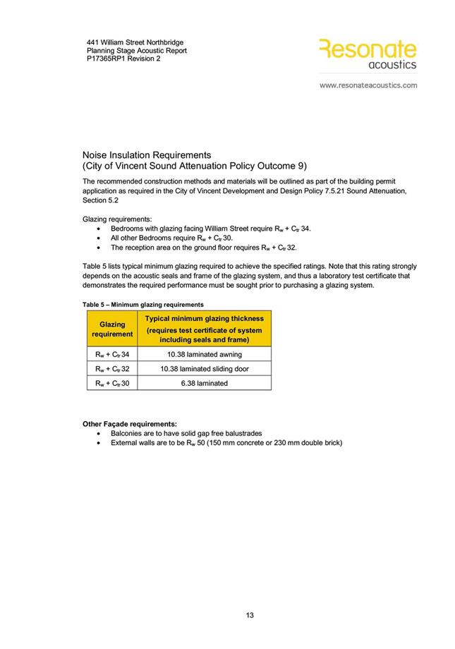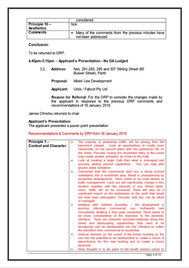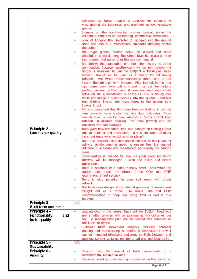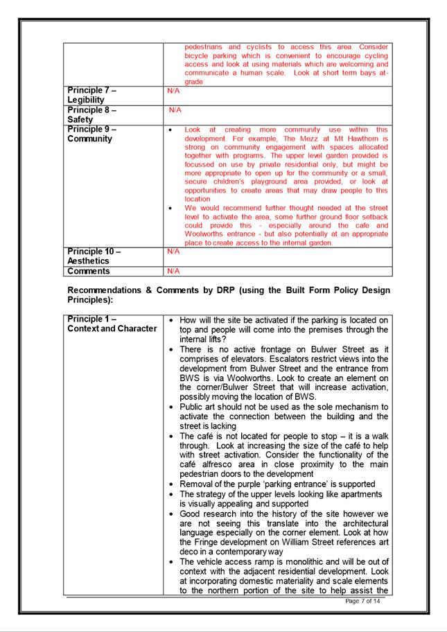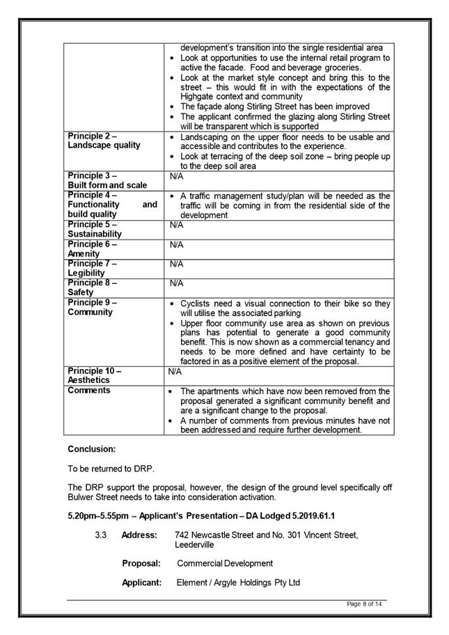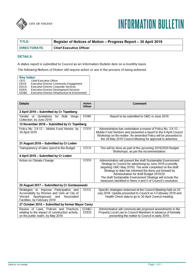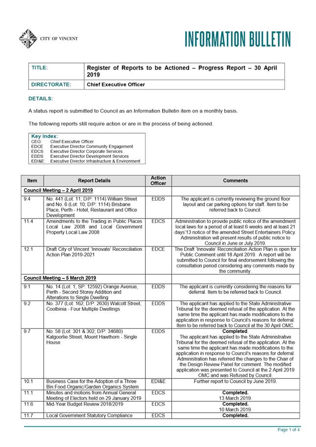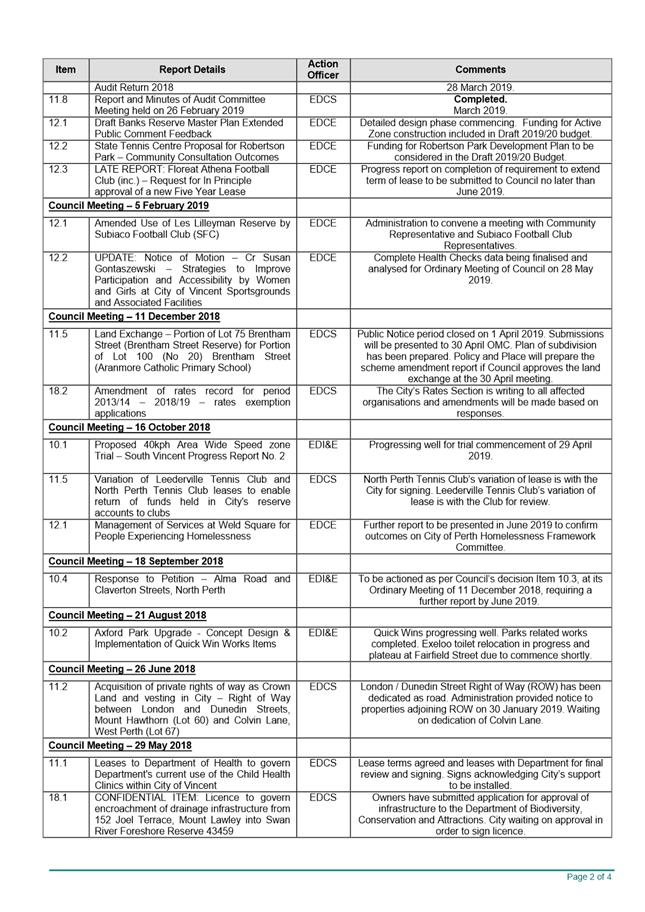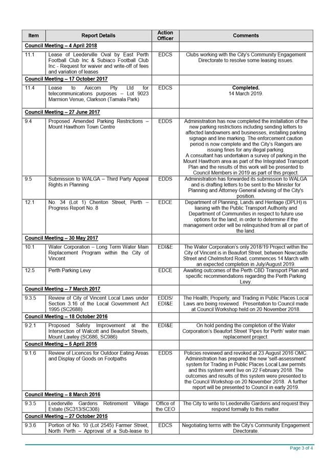
AGENDA
Ordinary Council Meeting
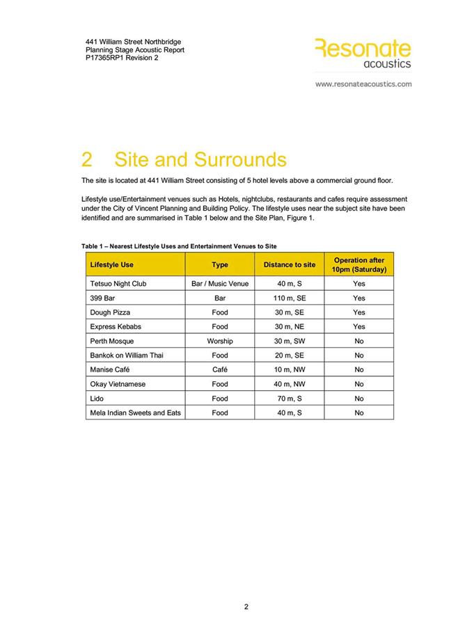
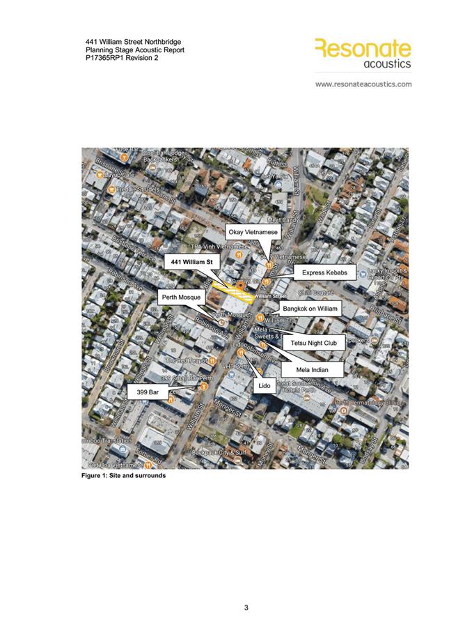
30 April 2019
|
Time: |
6pm |
|
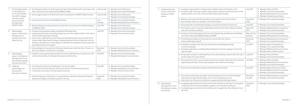
Location: |
Administration and Civic Centre 244 Vincent Street, Leederville |
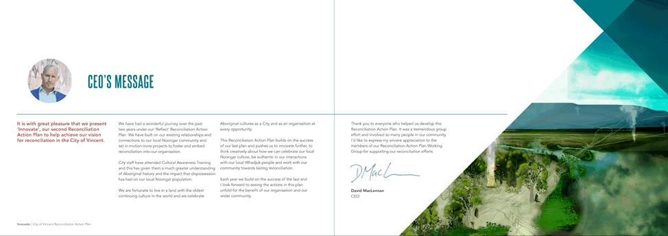
David MacLennan
Chief Executive Officer
AGENDA
Ordinary Council Meeting
30 April 2019
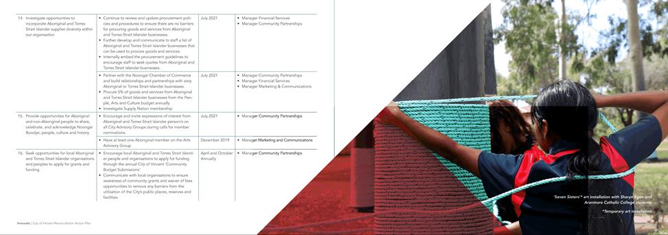
|
Time: |
6pm |
|
Location: |
Administration and Civic Centre 244 Vincent Street, Leederville |
David MacLennan
Chief Executive Officer
Ordinary Council Meeting Agenda 30 April 2019
DISCLAIMER
No responsibility whatsoever is implied or accepted by the City of Vincent (City) for any act, omission, statement or intimation occurring during Council Briefings or Council Meetings. The City disclaims any liability for any loss however caused arising out of reliance by any person or legal entity on any such act, omission, statement or intimation occurring during Council Briefings or Council Meetings. Any person or legal entity who acts or fails to act in reliance upon any statement, act or omission made in a Council Briefing or Council Meeting does so at their own risk.
In particular and without derogating in any way from the broad disclaimer above, in any discussion regarding any planning or development application or application for a licence, any statement or intimation of approval made by an Elected Member or Employee of the City during the course of any meeting is not intended to be and is not to be taken as notice of approval from the City. The City advises that anyone who has any application lodged with the City must obtain and should only rely on WRITTEN CONFIRMATION of the outcome of the application, and any conditions attaching to the decision made by the Council in respect of the application.
Copyright
Any plans or documents contained within this Agenda may be subject to copyright law provisions (Copyright Act 1968, as amended) and that the express permission of the copyright owner(s) should be sought prior to their reproduction. It should be noted that Copyright owners are entitled to take legal action against any persons who infringe their copyright. A reproduction of material that is protected by copyright may represent a copyright infringement.
PROCEDURE FOR PUBLIC SPEAKING TIME
The City of Vincent Local Law Relating to Meeting Procedures prescribes the procedure for persons to ask questions or make public statements relating to a matter affecting the City, either verbally or in writing, at a Council meeting.
Questions or statements made at an Ordinary Council meeting can relate to matters that affect the City. Questions or statements made at a Special Meeting of the Council must only relate to the purpose for which the meeting has been called.
1. Shortly after the commencement of the meeting, the Presiding Member will ask members of the public to come forward to address the Council and to give their name and the suburb in which they reside or, where a member of the public is representing the interests of a business, the suburb in which that business is located and Agenda Item number (if known).
2. Public speaking time will be strictly limited to three (3) minutes per member of the public.
3. Members of the public are encouraged to keep their questions/statements brief to enable everyone who desires to ask a question or make a statement to have the opportunity to do so.
4. Public speaking time is declared closed when there are no further members of the public who wish to speak.
5. Questions/statements are to be directed to the Presiding Member and are to be made politely in good faith and are not to be framed in such a way as to reflect adversely or be defamatory on a Council Member or City Employee.
6. Where the Presiding Member is of the opinion that a member of the public is making a statement at a Council meeting, that does not affect the City, he may ask the person speaking to promptly cease.
7. Questions/statements and any responses will be summarised and included in the Minutes of the Council meeting.
8. Where practicable, responses to questions will be provided at the meeting. Where the information is not available or the question cannot be answered, it will be “taken on notice” and a written response will be sent by the Chief Executive Officer to the person asking the question. A copy of the reply will be included in the Agenda of the next Ordinary meeting of the Council.
9. It is not intended that public speaking time should be used as a means to obtain information that would not be made available if it was sought from the City’s records under Section 5.94 of the Local Government Act 1995 or the Freedom of Information (FOI) Act 1992. The CEO will advise the member of the public that the information may be sought in accordance with the FOI Act 1992.
RECORDING AND WEBSTREAMING OF COUNCIL MEETINGS
· All Ordinary and Special Council Meetings are electronically recorded except when the Council resolves to go behind closed doors;
· All recordings are retained as part of the City's records in accordance with the General Disposal Authority for Local Government Records produced by the Public Records Office;
· A copy of the recorded proceedings and/or a transcript of a particular section or all of a Council meeting is available in accordance with Policy No. 4.2.4 – Council Meetings – Recording and Web Streaming.
· Ordinary Meetings of Council and Council Briefings are streamed live on the internet in accordance with the City’s Policy – 4.2.4 - Council Meetings Recording and Web Streaming. It is another way the City is striving for transparency and accountability in what we do.
· The live stream can be accessed from http://webcast.vincent.wa.gov.au/video.php
· Images of the public gallery are not included in the webcast, however the voices of people in attendance may be captured and streamed.
· If you have any issues or concerns with the live streaming of meetings, please contact the City’s Manager Governance and Risk on 08 9273 6538.
Ordinary Council Meeting Agenda 30 April 2019
1 Declaration of Opening / Acknowledgement of Country
2 Apologies / Members on Leave of Absence
3 (A) Public Question Time and Receiving of Public Statements
(B) Response to Previous Public Questions Taken On Notice
4 Applications for Leave of Absence
5 The Receiving of Petitions, Deputations and Presentations
7 Announcements by the Presiding Member (Without Discussion)
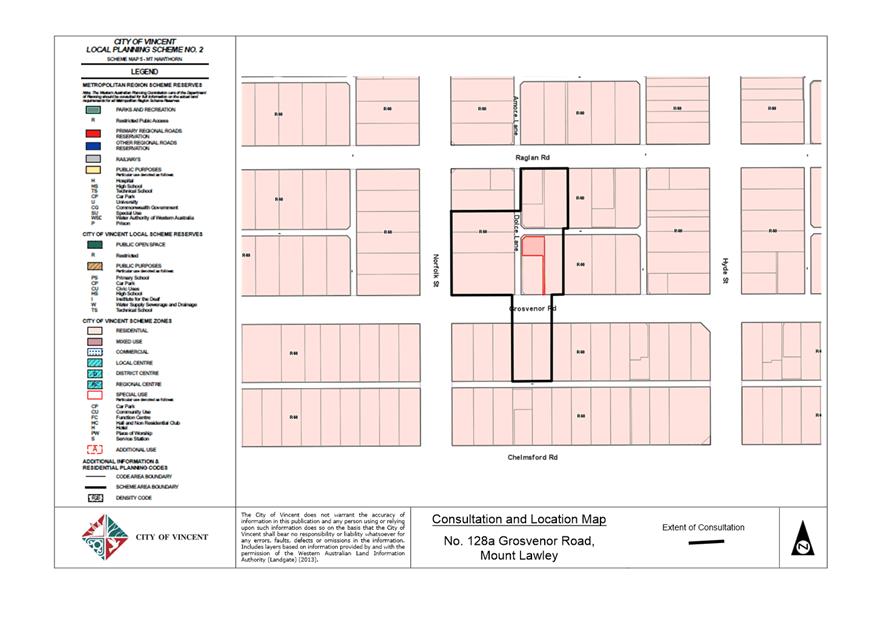
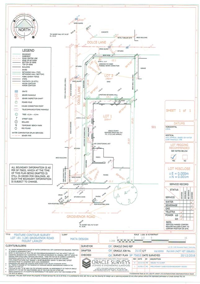
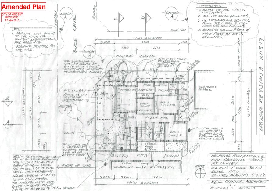
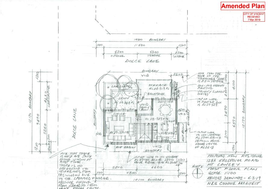
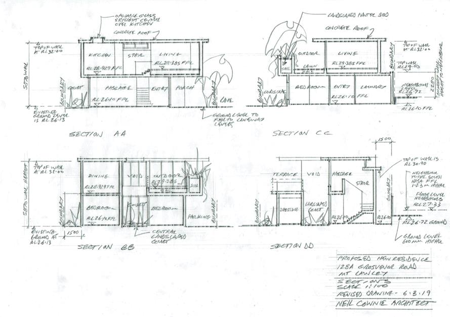
9.1 No. 128a (Lot: 2; STR: 75653) Grosvenor Road, Mount Lawley - Proposed Single House
9.2 No. 3 (Lot: 43; D/P: 1237) Alma Road, Mount Lawley - Grouped Dwelling
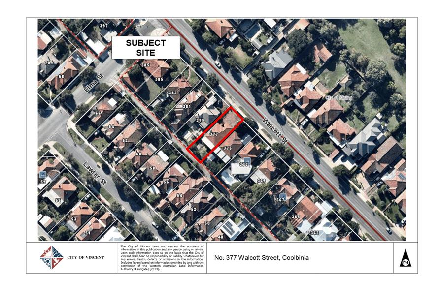
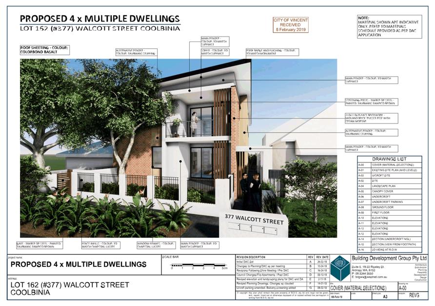
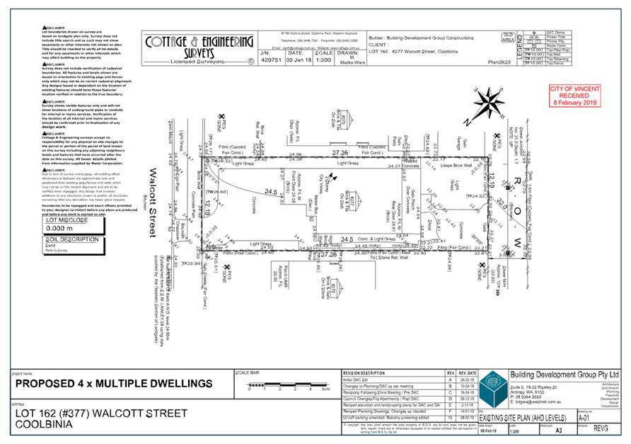
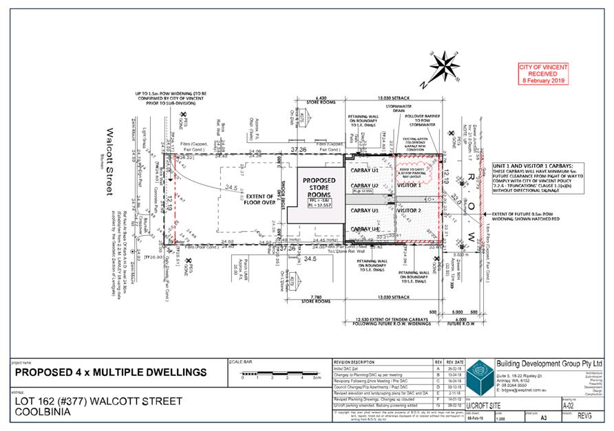
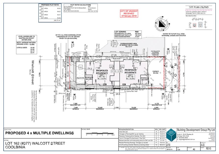
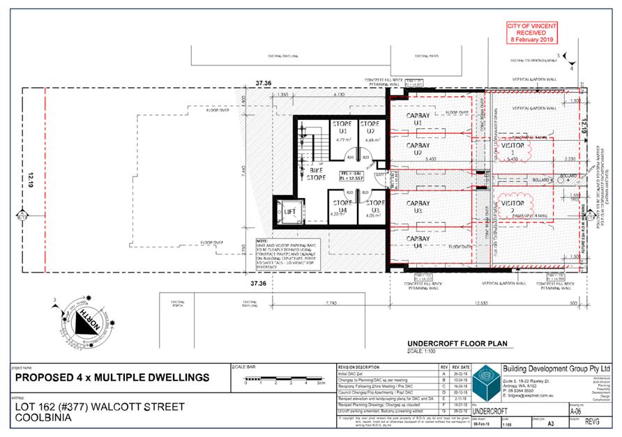
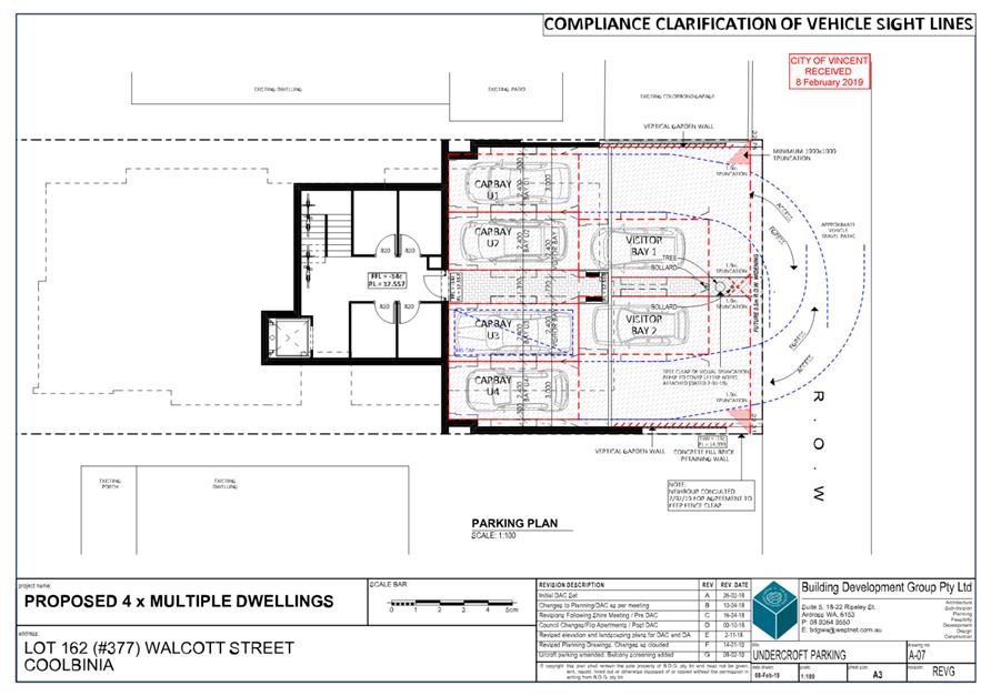
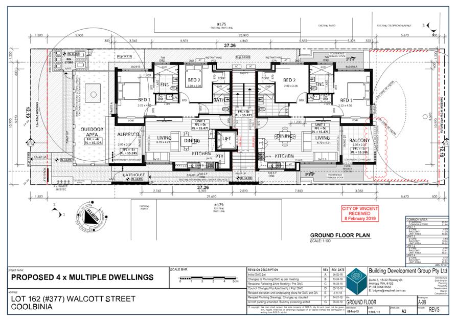
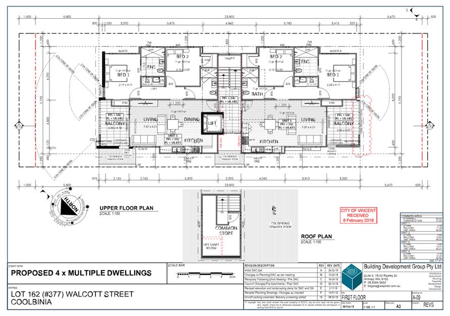
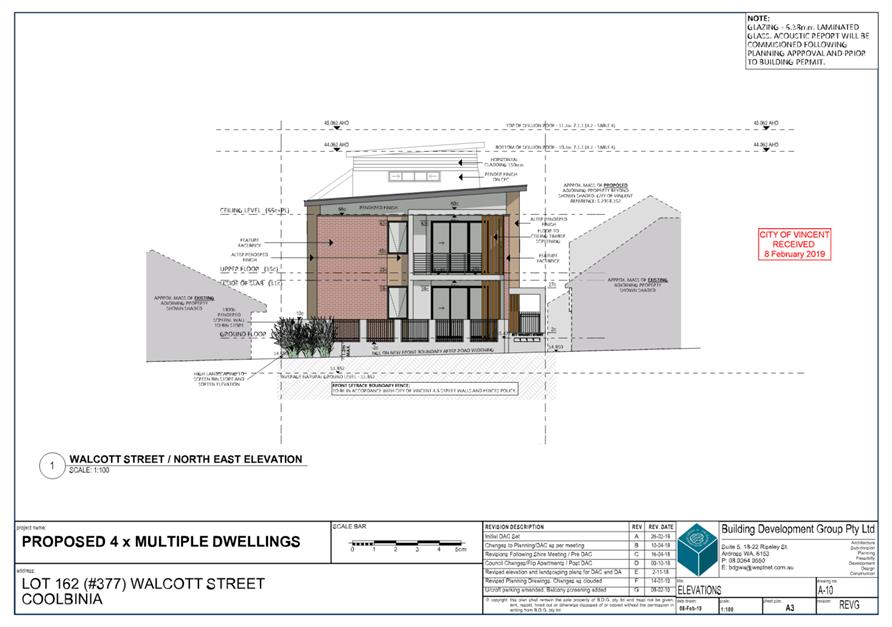
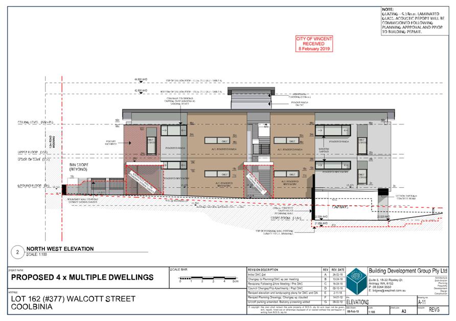
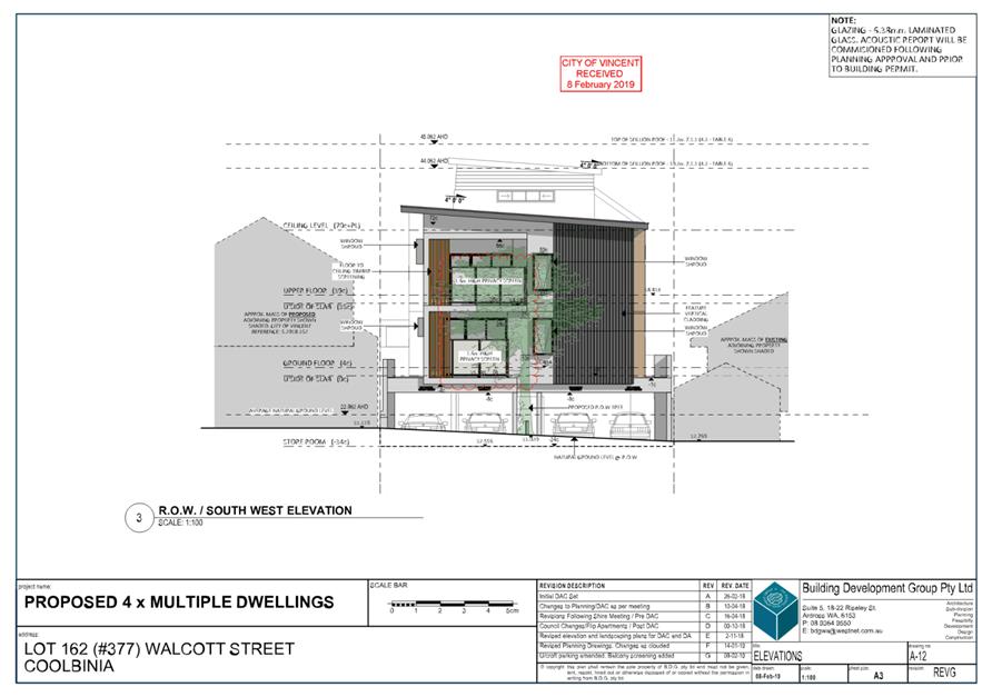
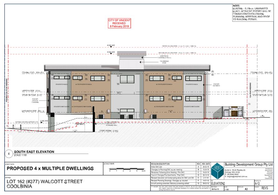
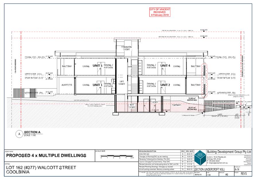
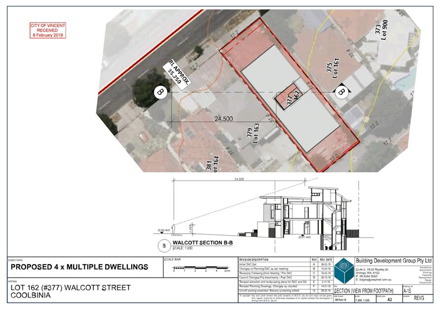
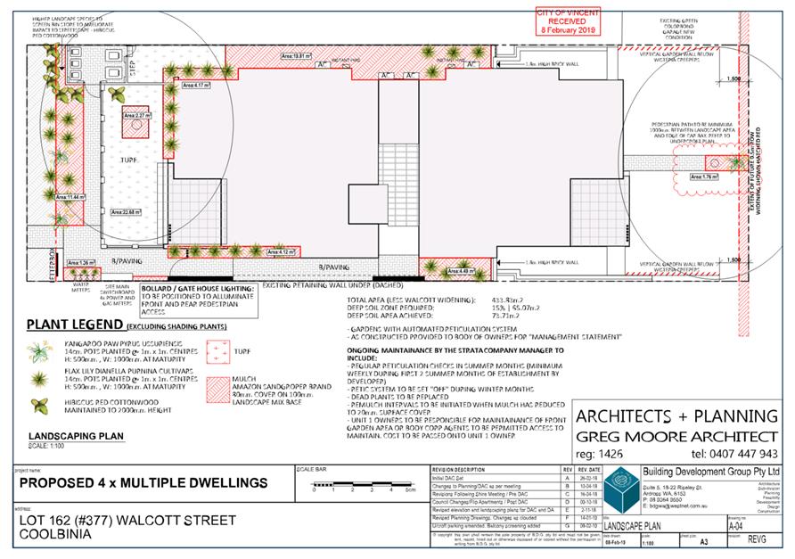
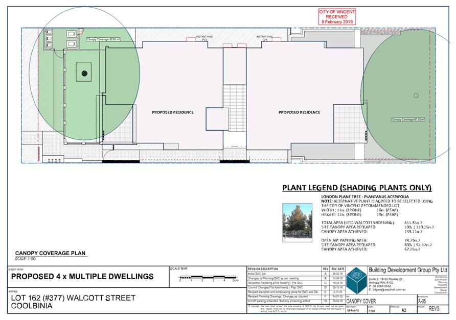
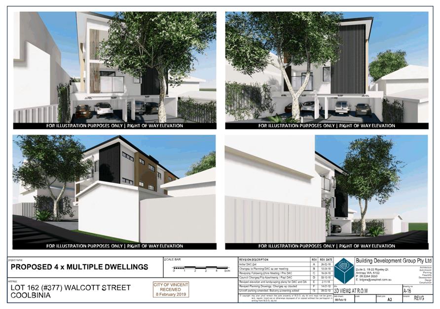
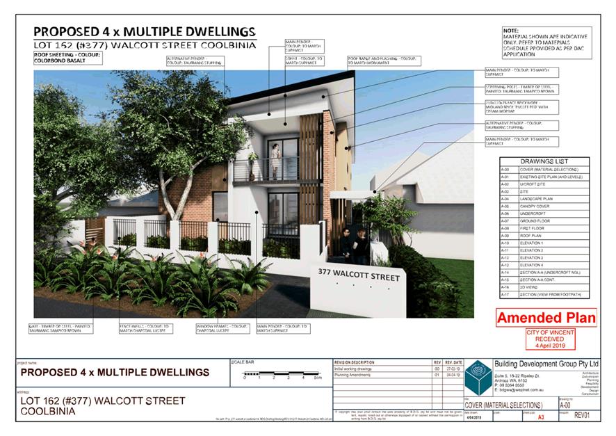
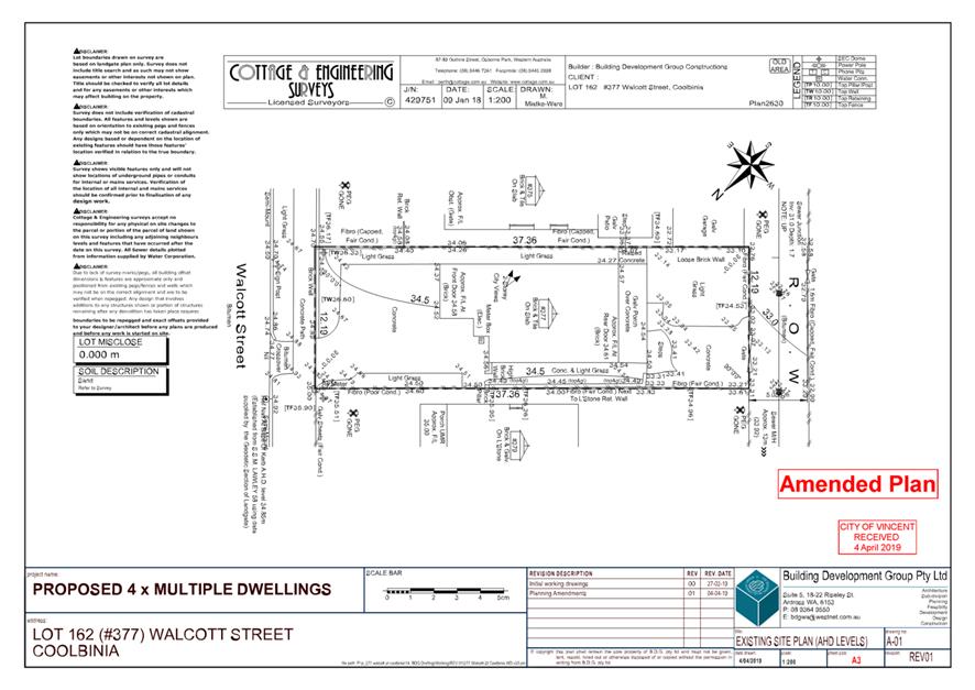
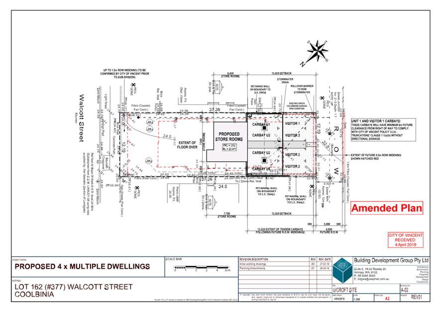
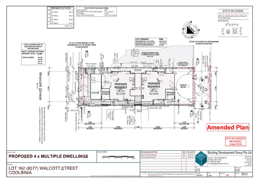
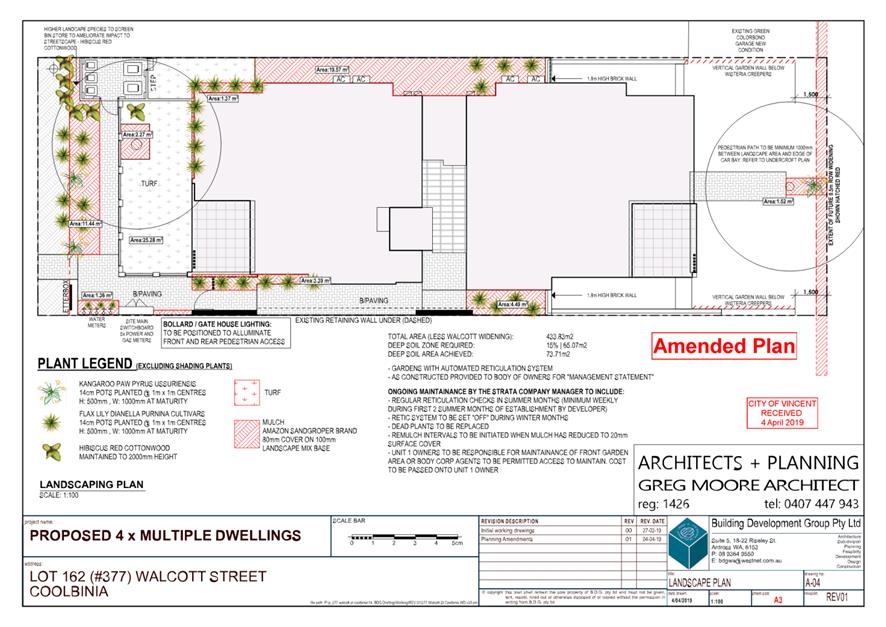
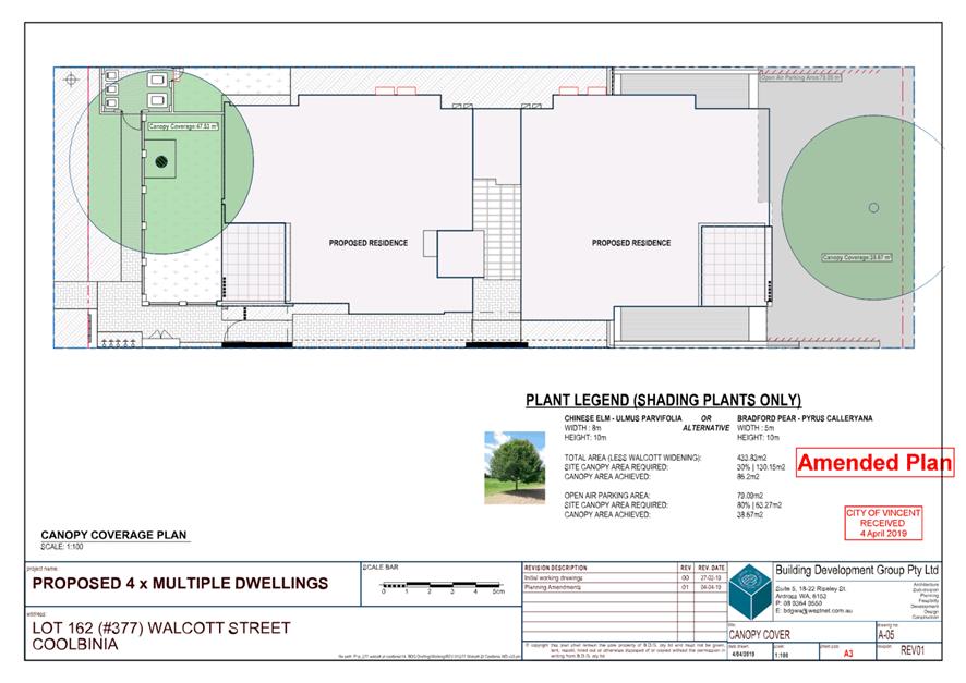
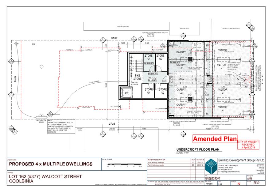
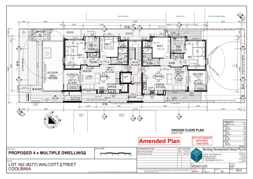
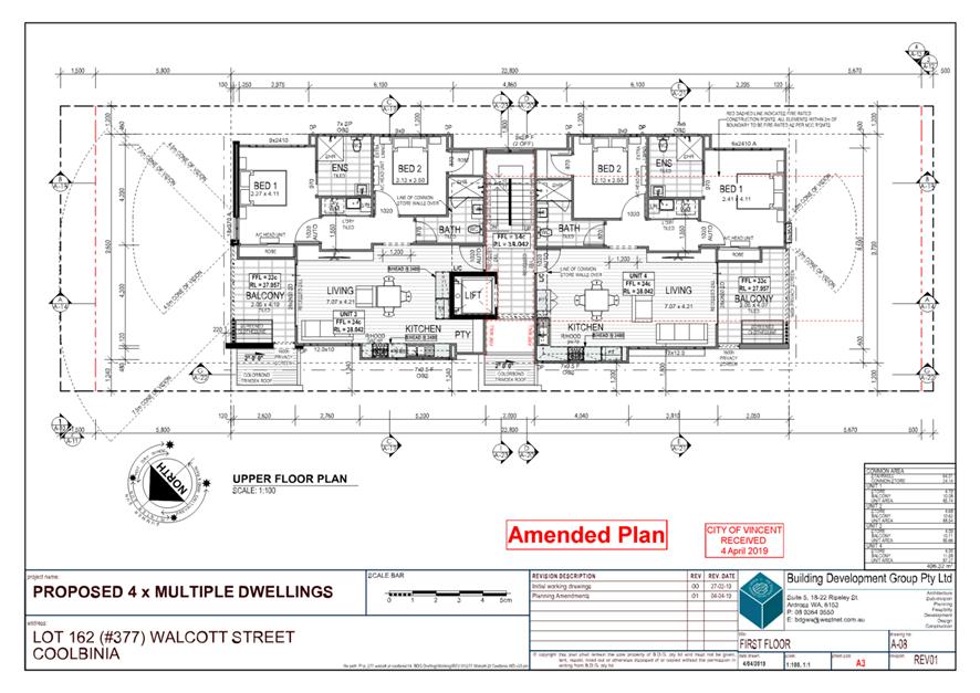
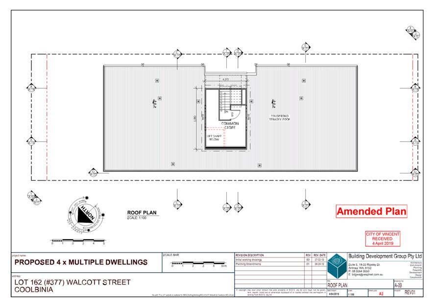
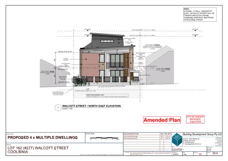
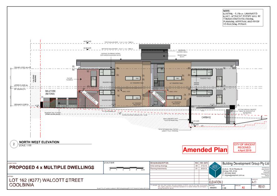
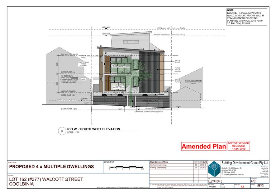
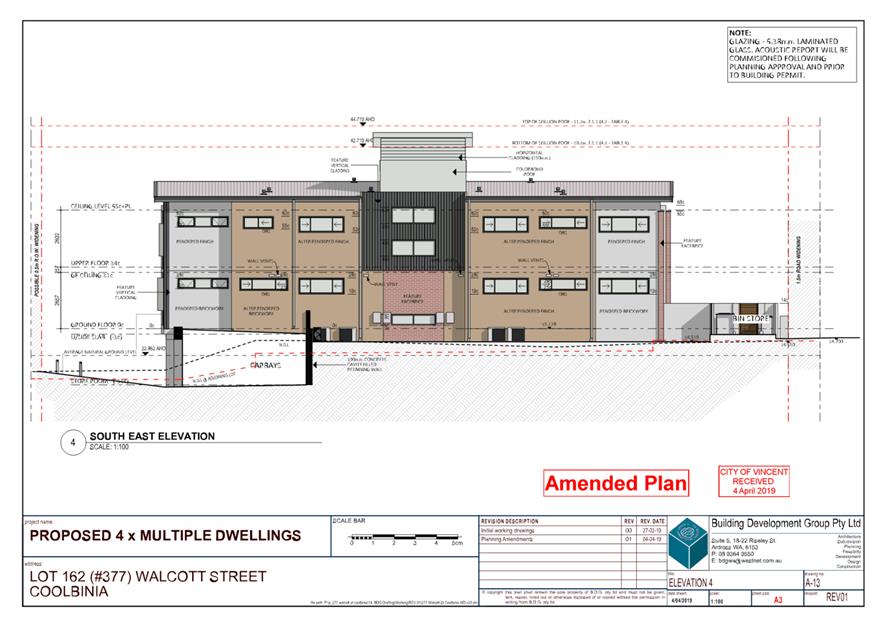
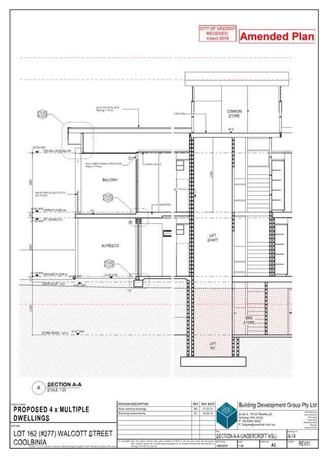
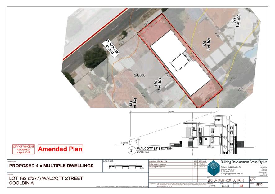
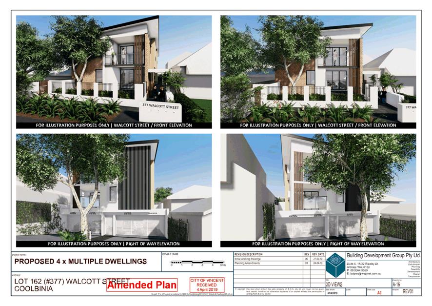
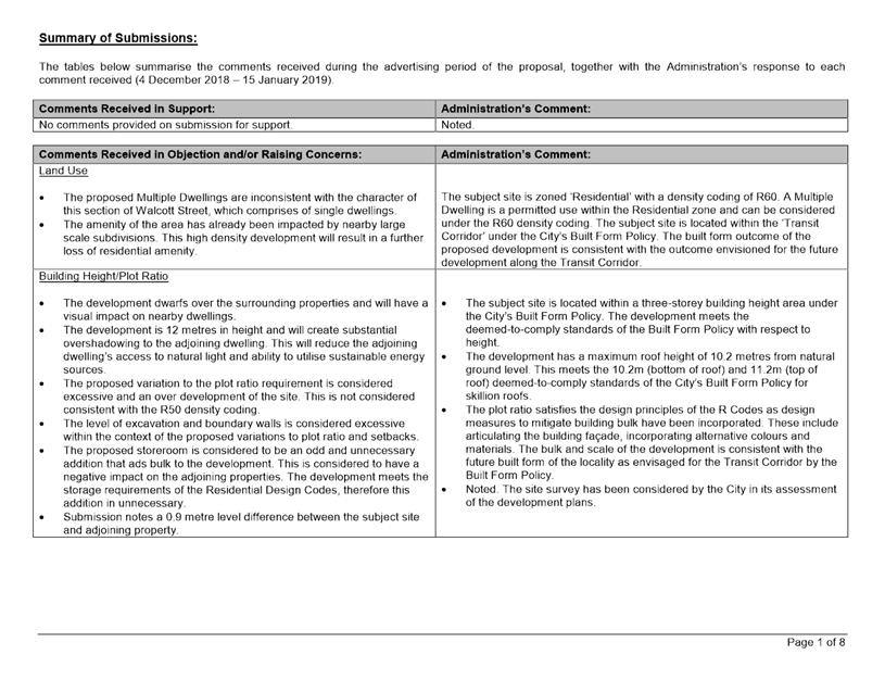
9.4 No. 377 (Lot: 162; D/P: 2630) Walcott Street, Coolbinia - Four Multiple Dwellings
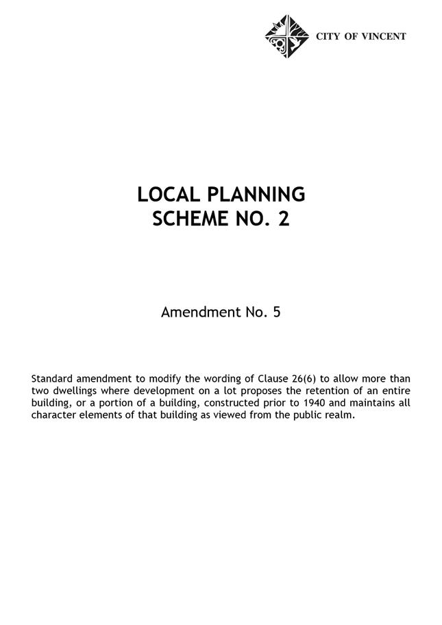
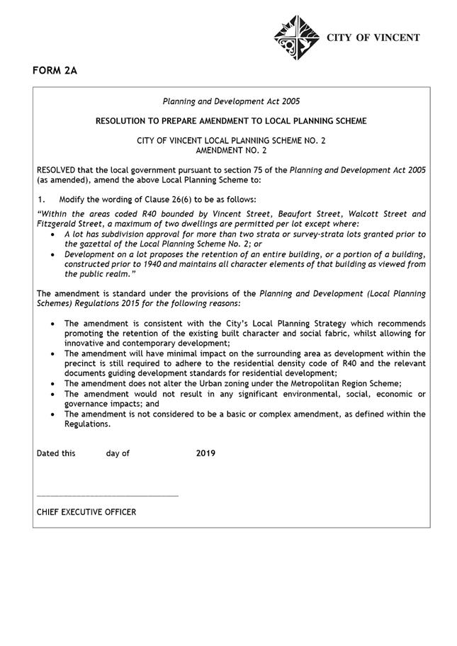
9.7 Character Retention and Amendment No. 5 to Local Planning Scheme No. 2
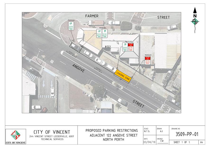
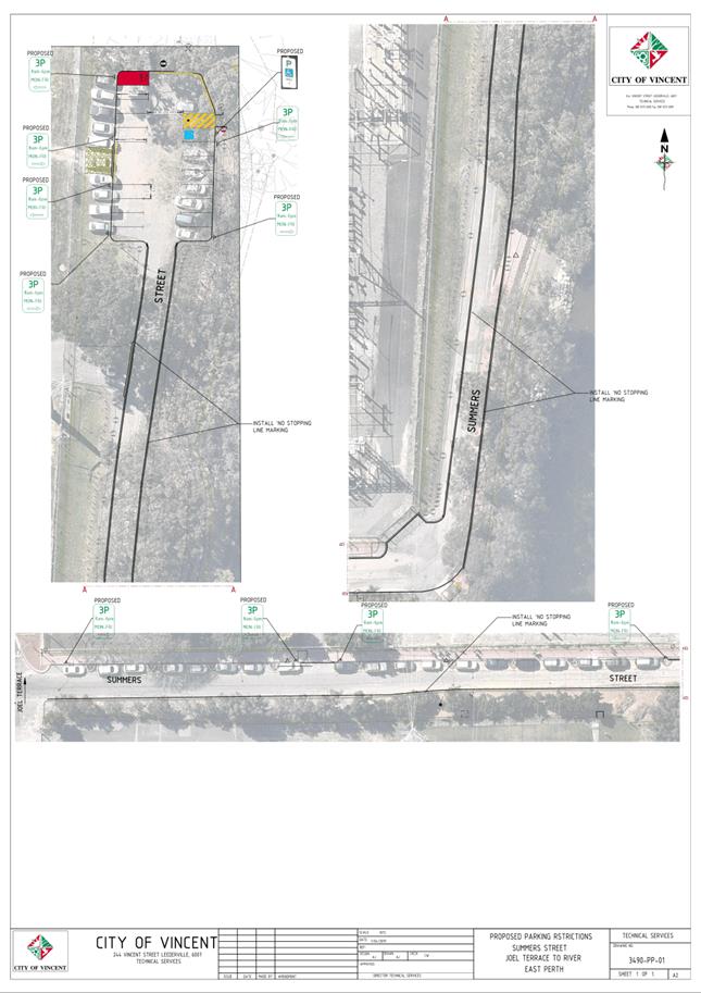
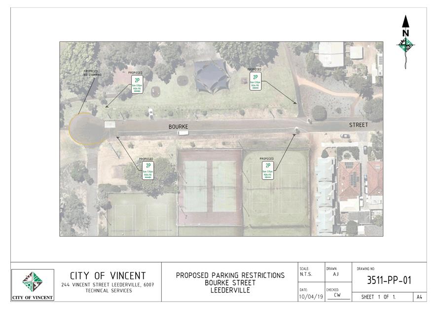
10.1 Minor Parking Restriction Improvements/Amendments
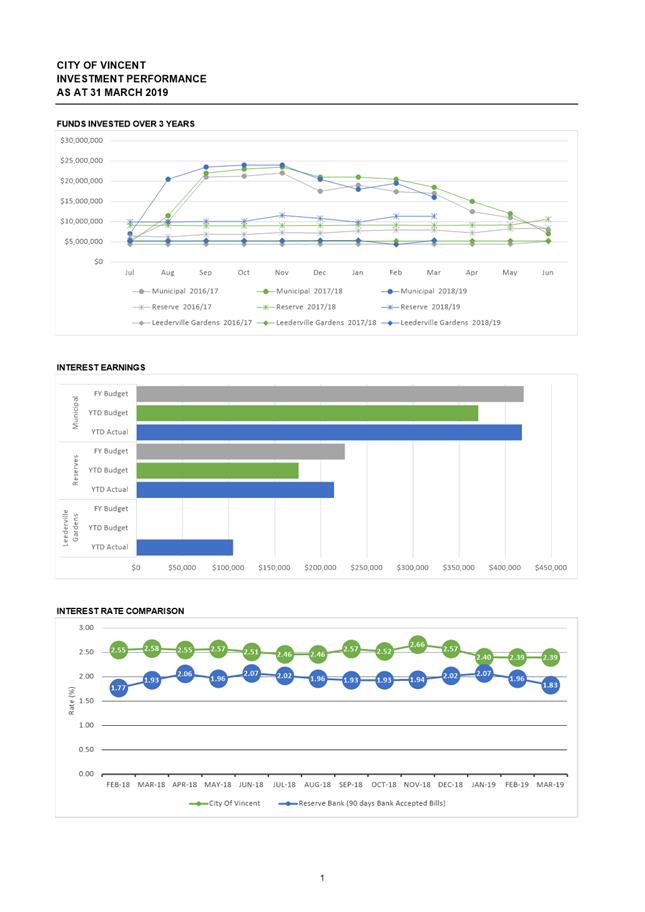
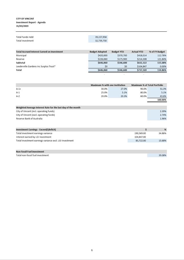
11.1 Investment Report as at 31 March 2019
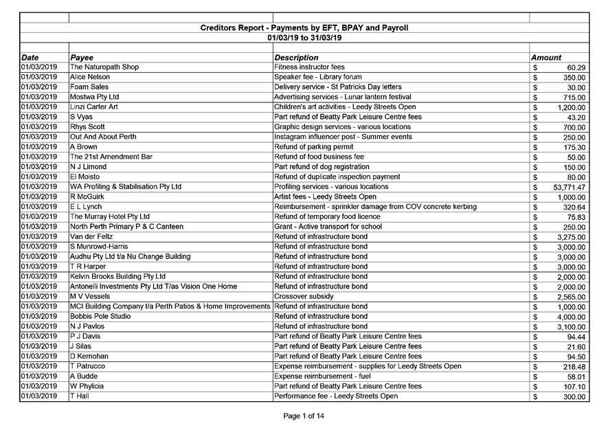
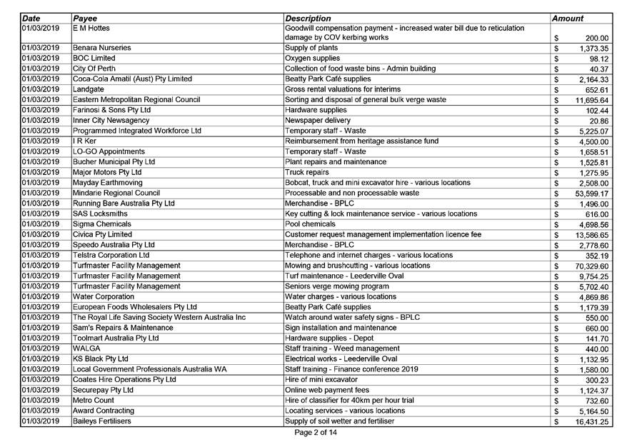
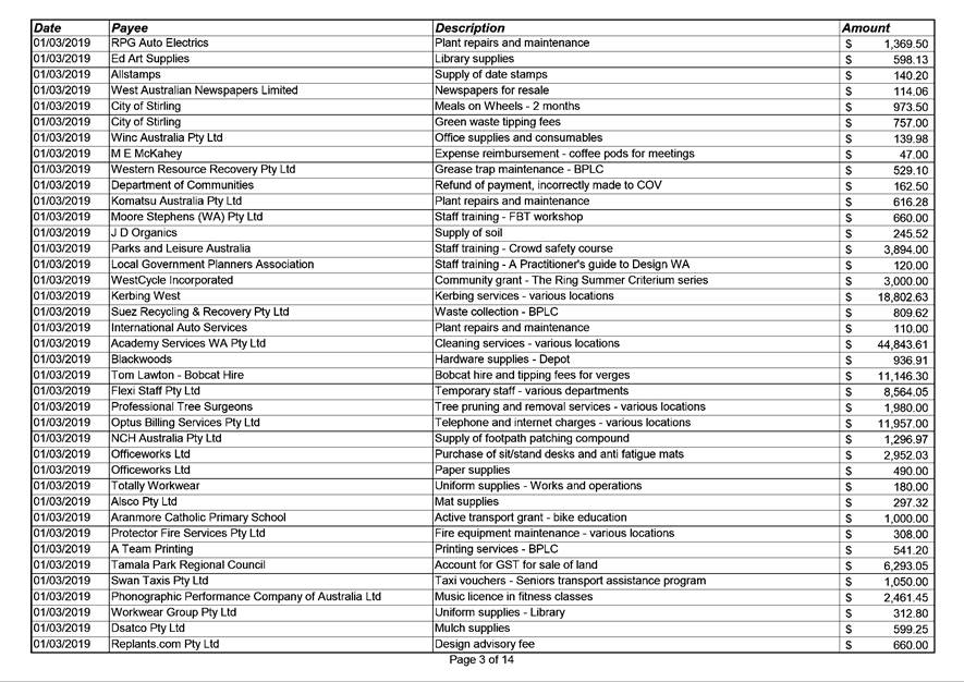
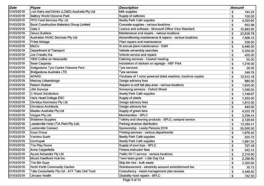
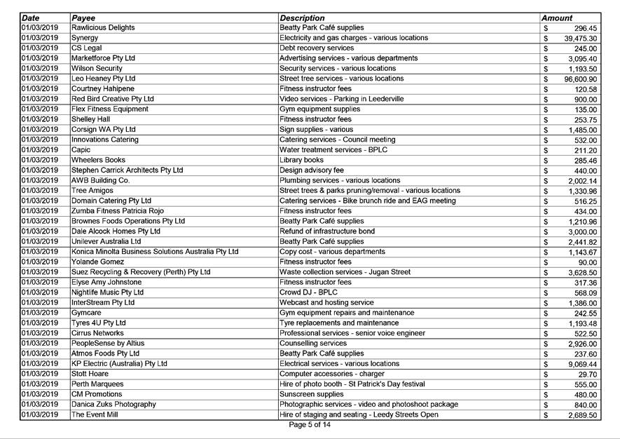
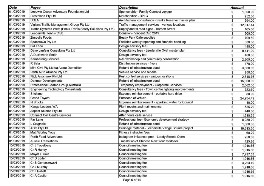
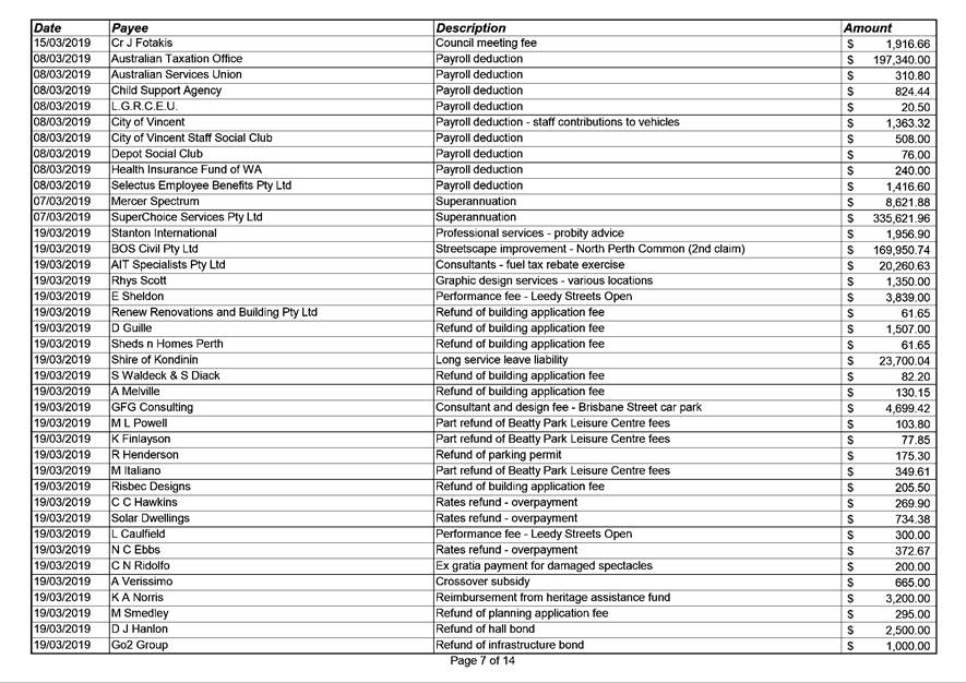
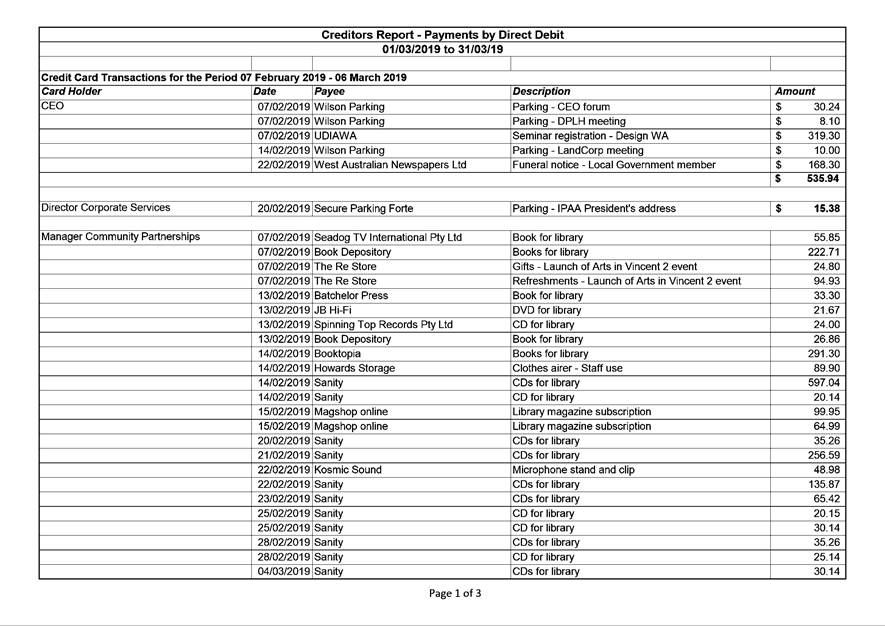
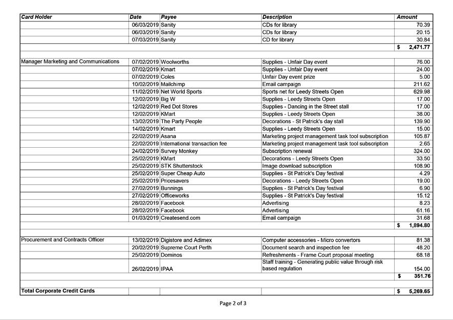
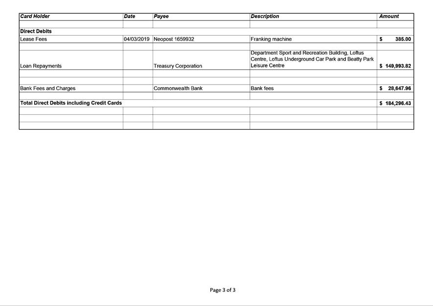
11.2 Authorisation of Expenditure for the Period 1 March 2019 to 31 March 2019
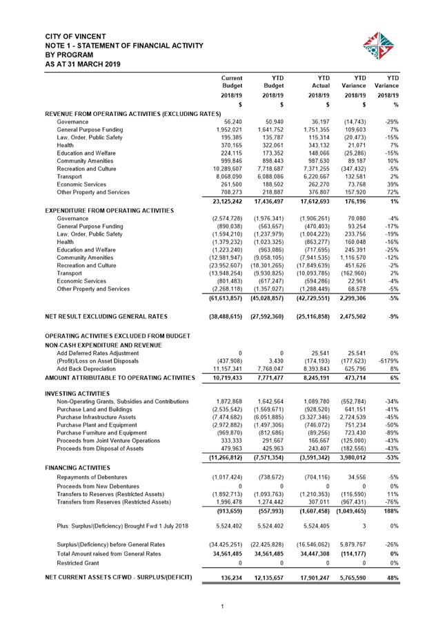
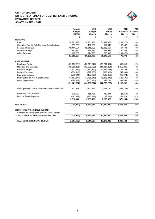
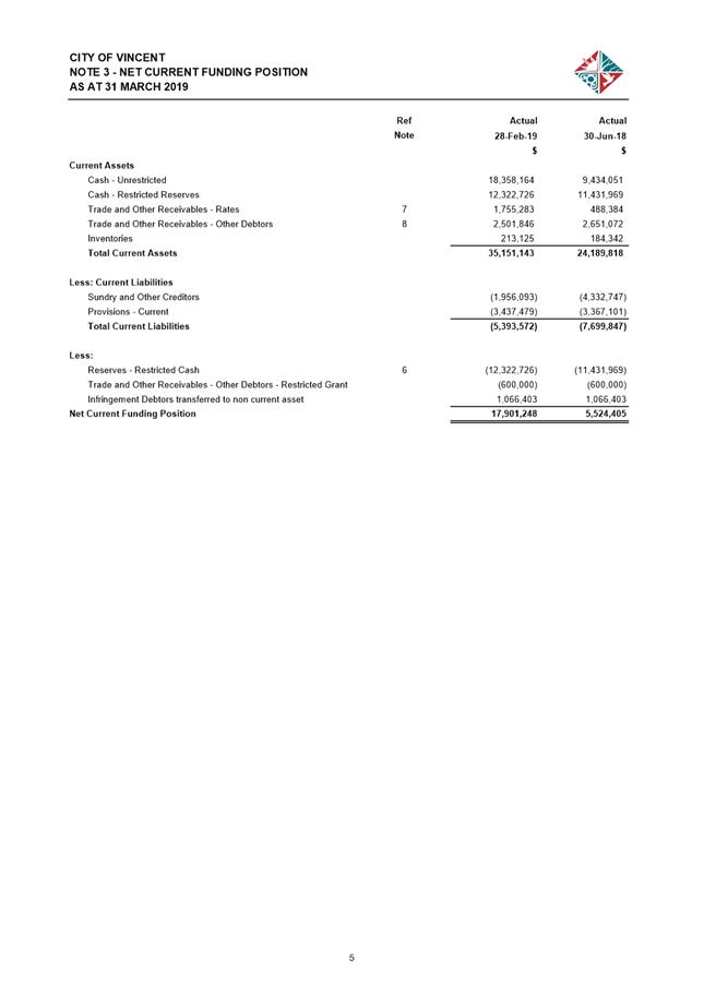
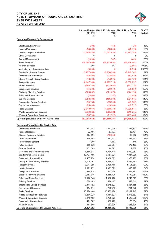
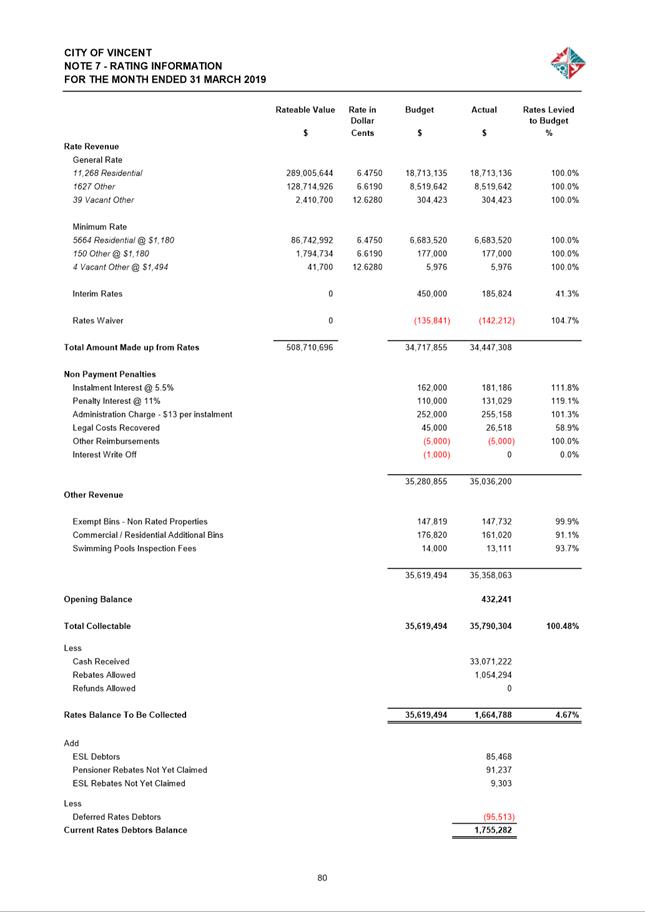
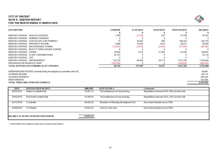
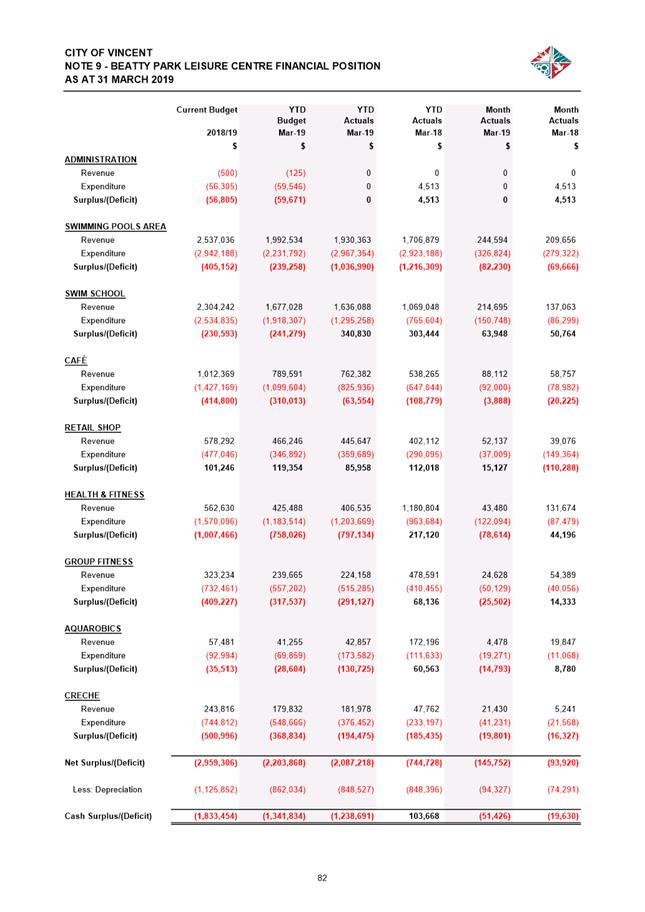
11.3 Financial Statements as at 31 March 2019
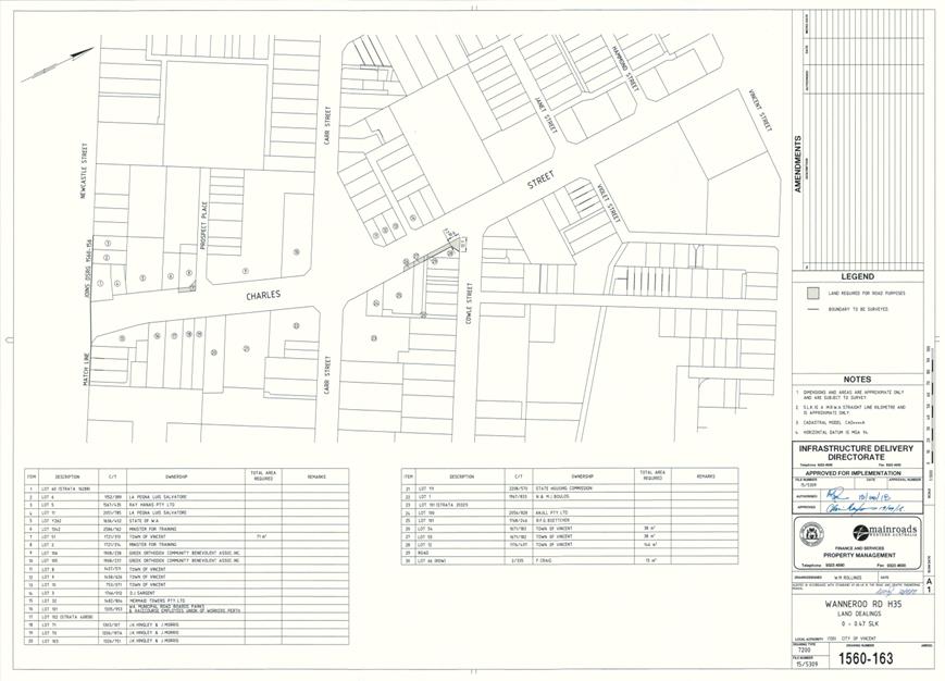
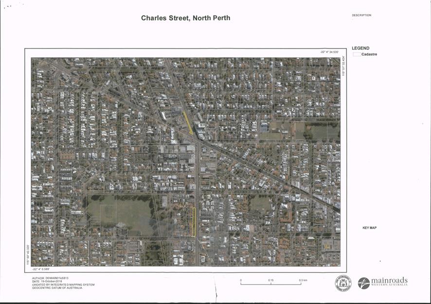
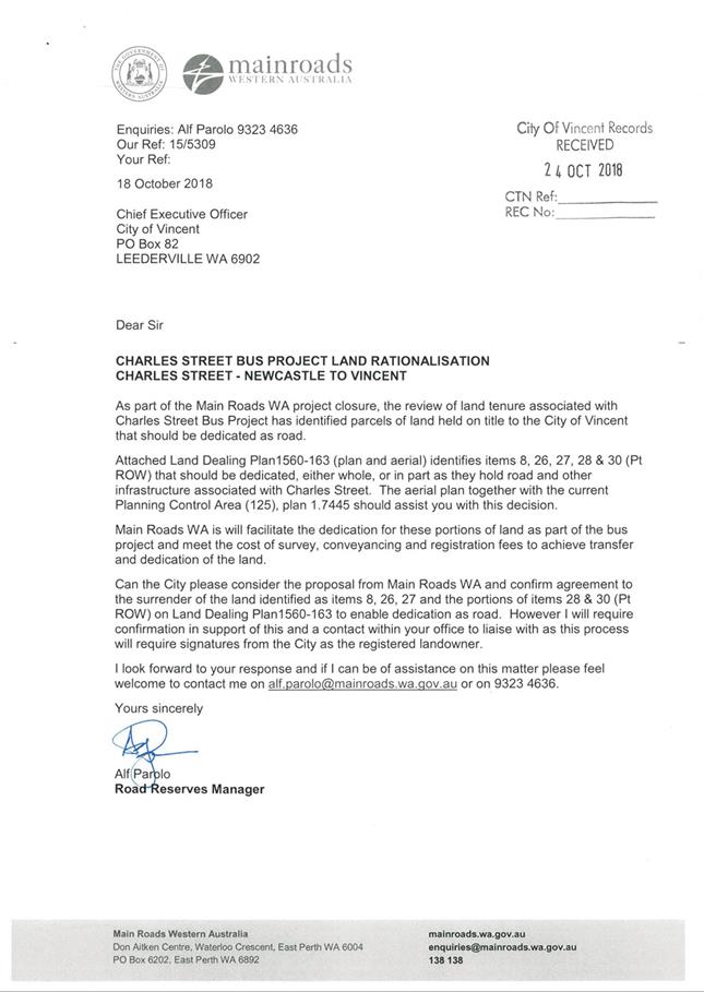
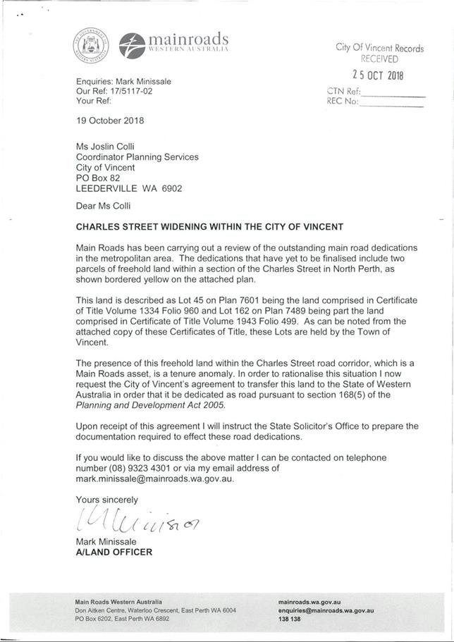
11.4 Transfer and dedication of lots as road - Charles Street, North Perth
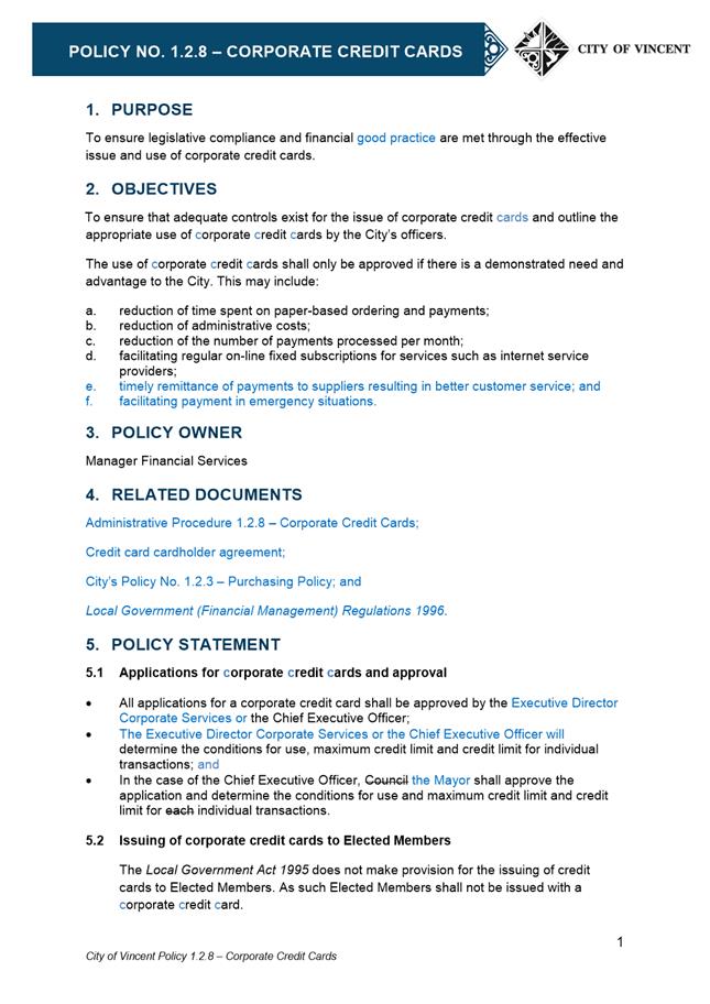
11.5 Amendment to Policy No. 1.2.8 - Corporate Credit Cards
12.1 Draft City of Vincent Innovate Reconciliation Action Plan 2019 - 2021
14 Motions of Which Previous Notice Has Been Given
15 Questions by Members of Which Due Notice Has Been Given (Without Discussion)
16 Representation on Committees and Public Bodies
18 Confidential Items/Matters For Which The Meeting May Be Closed
18.1 Write-off of debts over the limitation period
18.2 Declaration of Chief Executive Officer's appointment to the Open House Perth Board
1 Declaration of Opening / Acknowledgement of Country
“The City of Vincent would like to acknowledge the Traditional Owners of the land, the Whadjuk people of the Noongar nation and pay our respects to Elders past, present and emerging”.
2 Apologies / Members on Leave of Absence
Nil
3 (A) Public Question Time and Receiving of Public Statements
(B) Response to Previous Public Questions Taken On Notice
4 Applications for Leave of Absence
5 The Receiving of Petitions, Deputations and Presentations
Ordinary Meeting - 2 April 2019
7 Announcements by the Presiding Member (Without Discussion)
TRIM Ref: D19/39166
Author: Dan McCluggage, Urban Planner
Authoriser: John Corbellini, Executive Director Development Services
Ward: South
Attachments: 1. Attachment
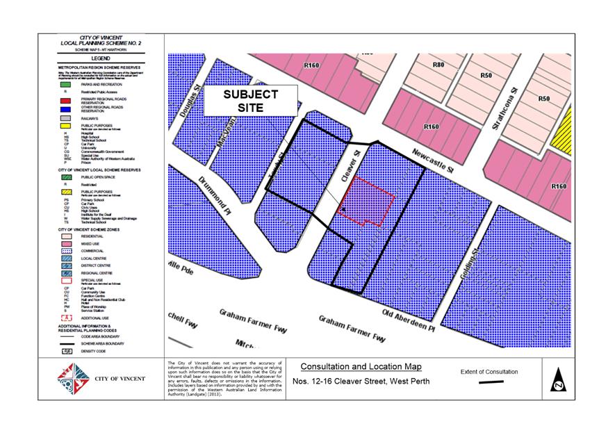
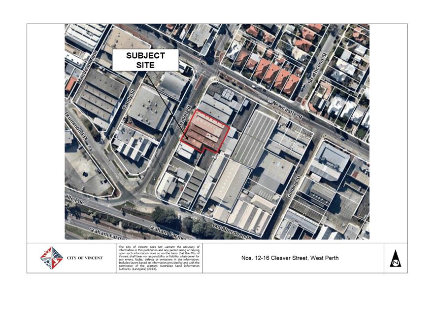
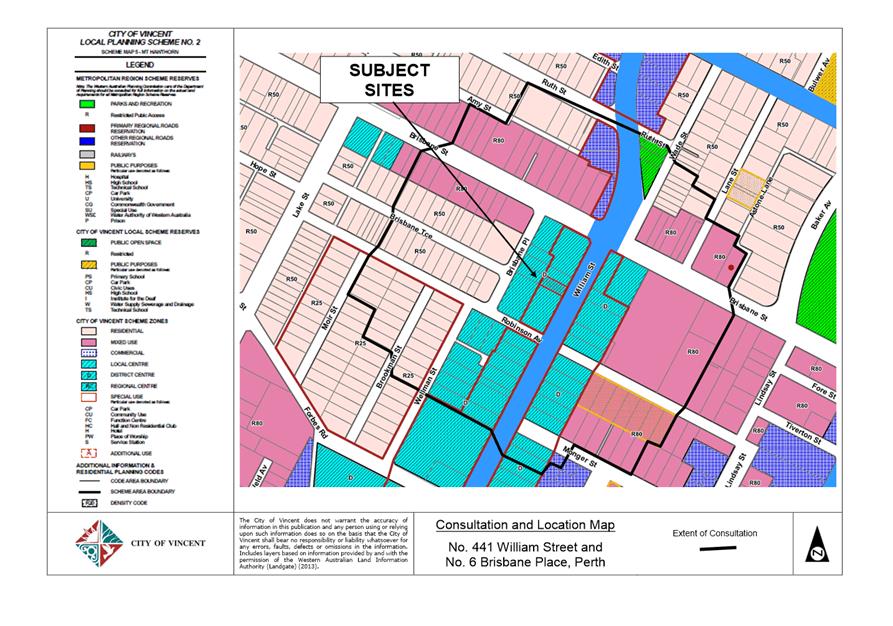
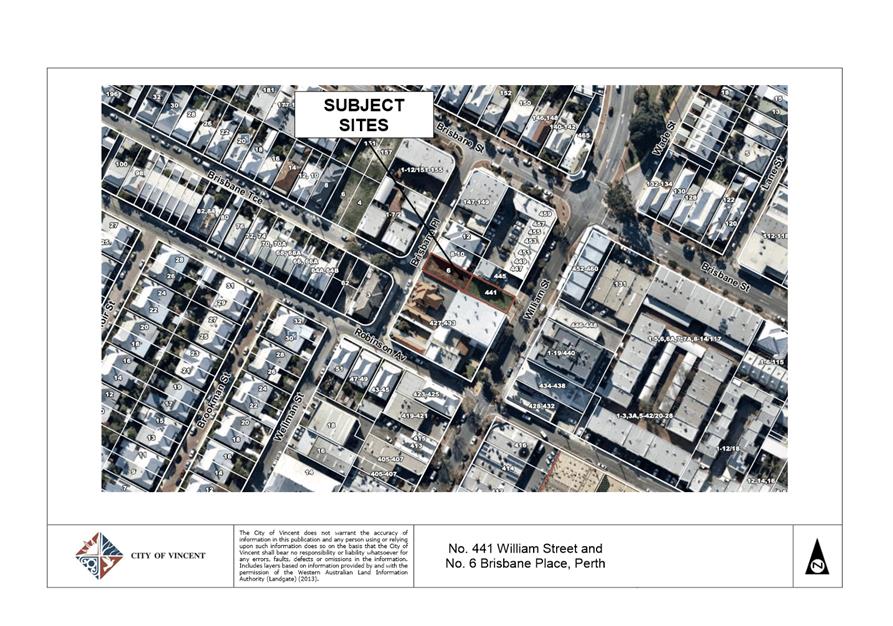
1 - Consultation and Location Map ⇩ ![]()
2. Attachment 2 -
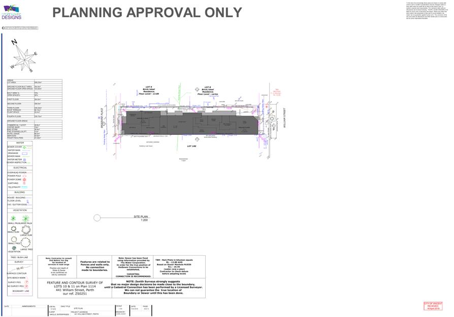
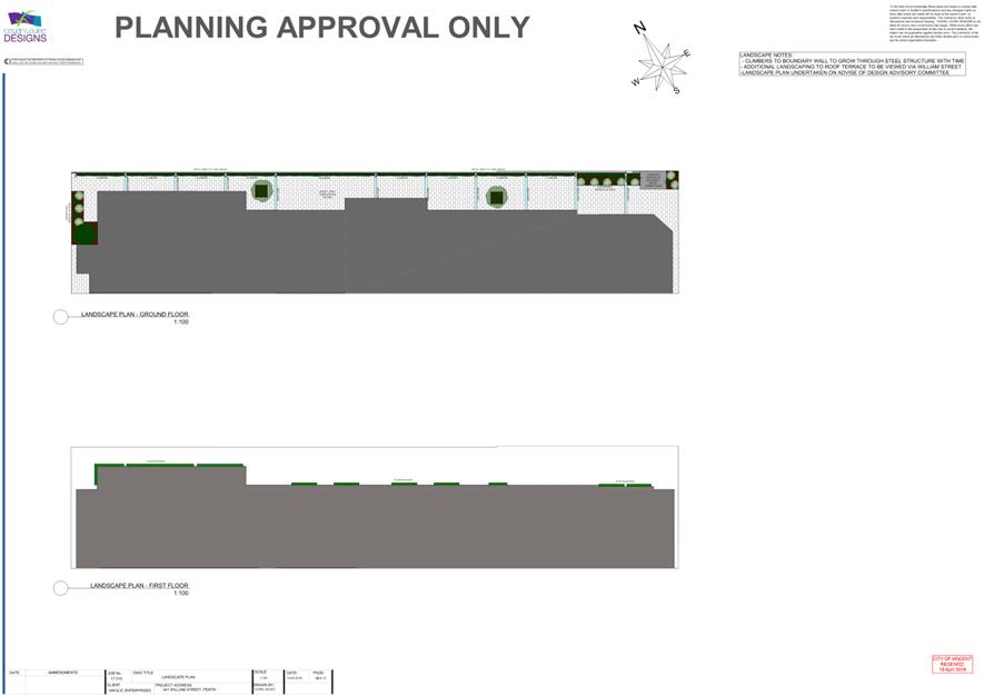
Development Plans ⇩ ![]()
3. Attachment 3 -
Summary of Submissions and Administration's Comments ⇩ ![]()
4. Attachment 4 -
Summary of Submissions and Applicant's Response ⇩ ![]()
5. Attachment 5 -
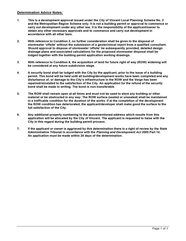
Determination Advice Notes ⇩ ![]()
|
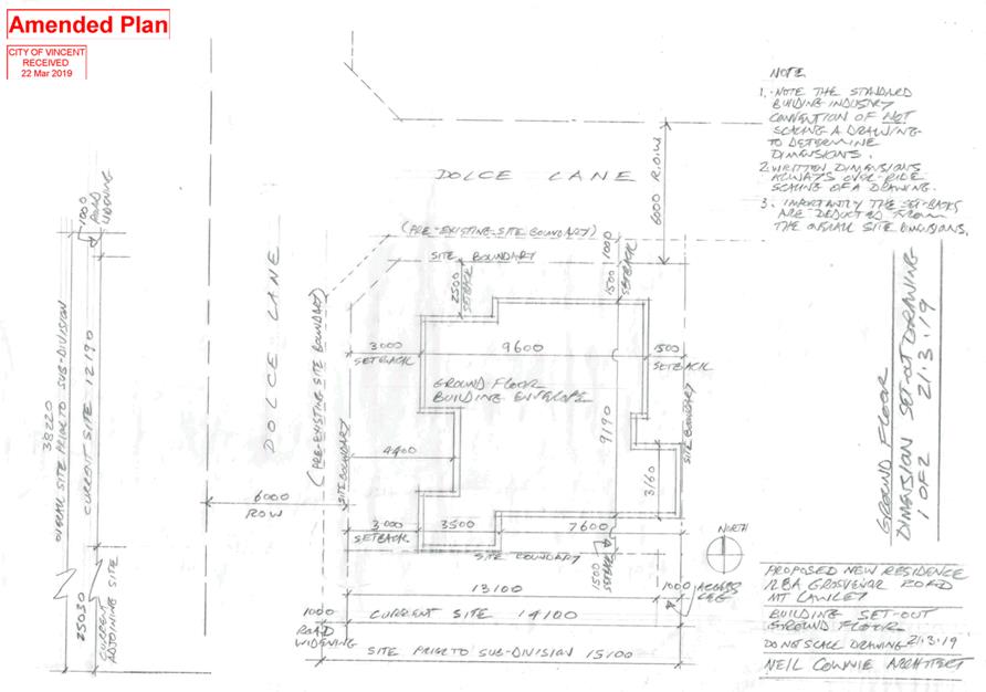
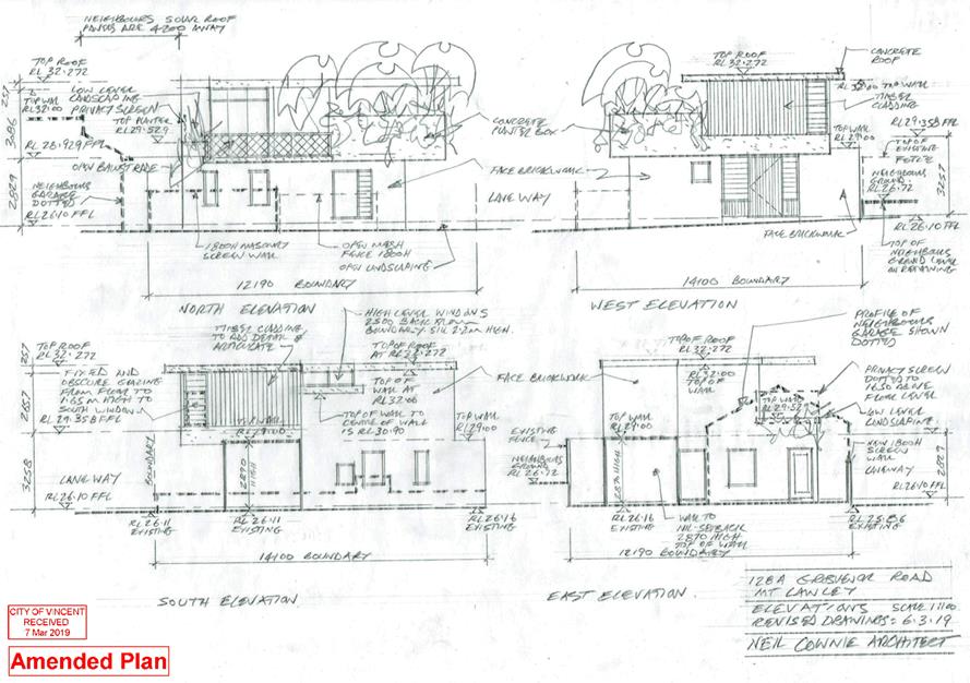
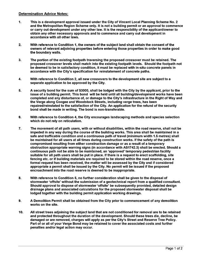
That Council, in accordance with the provisions of the City of Vincent Local Planning Scheme No. 2 and the Metropolitan Region Scheme, APPROVES the application for a Single House at No. 128A (Lot: 2; STR: 75653) Grosvenor Road, Mount Lawley, in accordance with the plans shown in Attachment 2, subject to the following conditions, with the associated determination advice notes in Attachment 5: 1. Boundary Walls The owners of the subject land shall finish and maintain the surface of the boundary wall facing No. 128 Grosvenor Road and No. 126 Grosvenor Road in a good and clean condition prior to practical completion of the development to the satisfaction of the City. The finish of the boundary walls is to be fully rendered or face brickwork to the satisfaction of the City; 2. Car Parking and Access 2.1 The car parking and access areas shall be sealed, drained and paved in accordance with the approved plans and are to comply with the requirements of AS2890.1 prior to occupancy or use of the development; 2.2 Vehicle access points are required to match into existing right of way levels; and 2.3 All new crossovers shall be constructed in accordance with the City’s Standard Crossover Specifications; 3. External Fixtures All external fixtures, such as television antennas (of a non-standard type), radio and other antennaes, satellite dishes, solar panels, external hot water heaters, air conditioners, meter boxes and the like, shall not be visible from the street or are to be integrated with the design of the building, to the satisfaction of the City; 4. Landscaping Plan 4.1 A detailed landscape and reticulation plan for the development site and adjoining road verge, to the satisfaction of the City, shall be lodged with and approved by the City prior to commencement of the development. The plan shall be drawn to a scale of 1:100 and show the following: · The location and type of existing and proposed trees and plants; · Areas to be irrigated or reticulated; · The proposed tree species in the south western corner of the site being changed from Honey Locust (Gleditsia tricanthos) to Crepe Myrtle (Lagerstroemia indica); and · The provision of 24.8 per cent of the site area as deep soil zone and 31.1 percent canopy cover at maturity; and 4.2 All works shown in the plans as identified in condition 4.1 above shall be undertaken in accordance with the approved plans to the City’s satisfaction, prior to occupation or use of the development and shall be maintained thereafter to the satisfaction of the City at the expense of the owners/occupiers; 5. Stormwater All stormwater produced on the subject land shall be retained on site by suitable means to the satisfaction of the City; 6. Visual Privacy Prior to occupation or use of the development, all privacy screening shall be visually impermeable and is to comply in all respects with the requirements of Clause 5.4.1 of the Residential Design Codes (Visual Privacy) deemed to comply standards, to the satisfaction of the City; and 7. Sight Lines No walls, letterboxes or fences above 0.75 metres in height shall be constructed within 1.5 metres of where: 7.1 walls, letterboxes or fences adjoin vehicular access points to the site; or 7.2 a driveway meets a public street; or 7.3 two streets intersect; unless otherwise approved by the City of Vincent. |
Purpose of Report:
To consider an application for development approval for a single house at No. 128A Grosvenor Road, Mount Lawley (the subject site).
PROPOSAL:
The application proposes a two storey Single House on the subject site with vehicle and primary pedestrian access from Dolce Lane to the west.
Background:
|
Landowner: |
Ryan Chu and Seren Chu |
|
Applicant: |
Neil Cownie Architect |
|
Date of Application: |
5 December 2018 |
|
Zoning: |
MRS: Urban LPS2: Zone: Residential R Code: R40 |
|
Built Form Area: |
Residential |
|
Existing Land Use: |
Vacant Land |
|
Proposed Use Class: |
Dwelling (Single) |
|
Lot Area: |
195m² |
|
Right of Way (ROW): |
Yes: Dolce Lane to the west – 5.0 metres wide, drained and sealed; and ROW to the north – 6.0 metres wide, drained and sealed. |
|
Heritage List: |
No. |
The subject site is currently vacant and bound by Dolce Lane to the west, a ROW to the north, a double storey single house to the east at No. 126 Grosvenor Road and a single storey single house to the south at No. 128 Grosvenor Road. The surrounding area is generally characterised by a mixture of both single and double storey dwellings.
The subject site is zoned Residential with a density coding of R40 under the City’s Local Planning Scheme No. 2 (LPS2). The subject site and the adjoining properties are within the Residential built form area under the City’s Policy No. 7.1.1 – Built Form (Built Form Policy).
The proposed development plans are included as Attachment 2.
Details:
Summary Assessment
The table below summarises the planning assessment of the proposal against the provisions of LPS2, the Built Form Policy and the State Government’s Residential Design Codes (R Codes). In each instance where the proposal requires the discretion of Council, the relevant planning element is discussed in the Detailed Assessment section following from this table.
|
Planning Element |
Use Permissibility/ Deemed-to-Comply |
Requires the Discretion of Council |
|
Site Area |
ü |
|
|
Street Setback |
ü |
|
|
Front Fence |
ü |
|
|
Lot Boundary Setback |
|
ü |
|
Building Height |
ü |
|
|
Open Space |
|
ü |
|
Outdoor Living Areas |
|
ü |
|
Landscaping |
ü |
|
|
Privacy |
|
ü |
|
Parking & Access |
|
ü |
|
Solar Access |
ü |
|
|
Site Works/Retaining Walls |
ü |
|
|
Essential Facilities |
ü |
|
|
External Fixtures |
ü |
|
|
Surveillance |
ü |
|
Detailed Assessment
The deemed-to-comply assessment of the element that requires the discretion of Council is as follows:
|
Lot Boundary Setback |
|
|
Deemed-to-Comply Standard |
Proposal |
|
R Codes Clause 5.1.3
East Ground Floor Ensuite to Bedroom 2 setback 1.8m to eastern boundary.
South Upper Living Room to Kitchen setback 1.6m to southern boundary. |
East Ground Floor Ensuite to Bedroom 2 setback 1.5m to eastern boundary.
South Upper Floor Living Room to Kitchen setback 1.5m to southern boundary. |
|
Open Space |
|
|
Deemed-to-Comply Standard |
Proposal |
|
R Codes Clause 5.4.1
45.0% of site area |
43.2% of site area |
|
Outdoor Living Area |
|
|
Deemed-to-Comply Standard |
Proposal |
|
R Codes Clause 5.3.1
Minimum dimension of 4.0m. |
Minimum dimension of 2.8m. |
|
Privacy |
|
|
Deemed-to-Comply Standard |
Proposal |
|
R Codes Clause 5.4.1
Upper floor terrace
Setback 7.5m from No. 101A Raglan Road to the north. |
Upper floor terrace
Setback 7.1m from No. 101A Raglan Road to the north. |
|
Parking & Access |
|
|
Deemed-to-Comply Standard |
Proposal |
|
R Codes Clause 5.3.3
Two on-site parking spaces. |
One on-site parking space. |
|
R Codes Clause 5.3.5
Driveways no closer than 6.0 metres to a street corner. |
The proposed vehicle access point is not setback from the corner of Dolce Lane and the ROW. |
The above elements of the proposal do not meet the specified deemed-to-comply standards and are discussed in the comments section below.
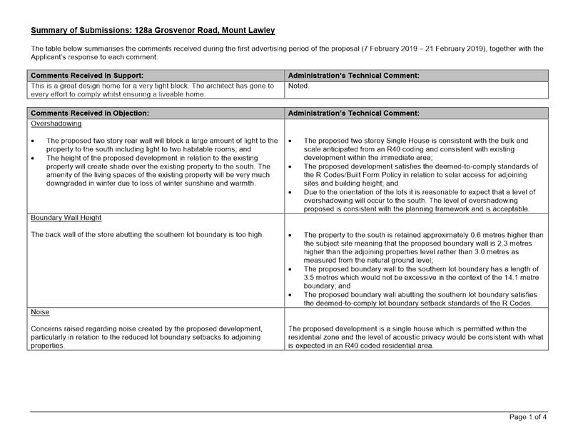
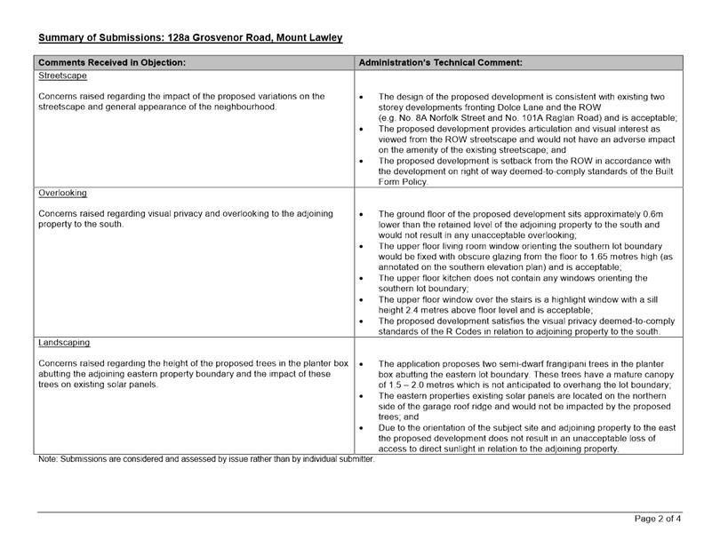
Consultation/Advertising:
Community consultation was undertaken in accordance with the Planning and Development (Local Planning Schemes) Regulations 2015, for a period of 14 days commencing on 7 February 2019 and concluding on 21 February 2019. The method of consultation being 13 letters mailed to all owners and occupiers surrounding the site (as shown in Attachment 1) and a notice on the City’s website, in accordance with the City’s Policy No. 4.1.5 – Community Consultation.
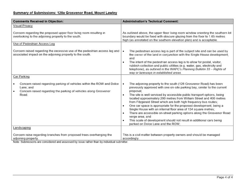
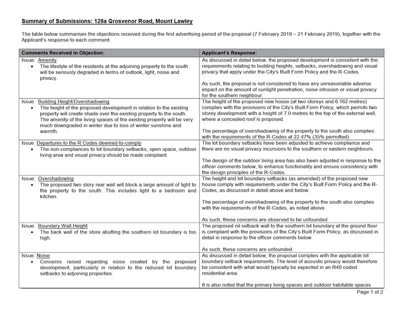
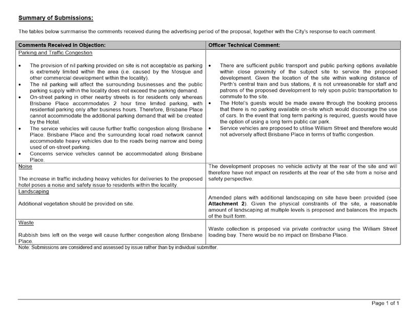
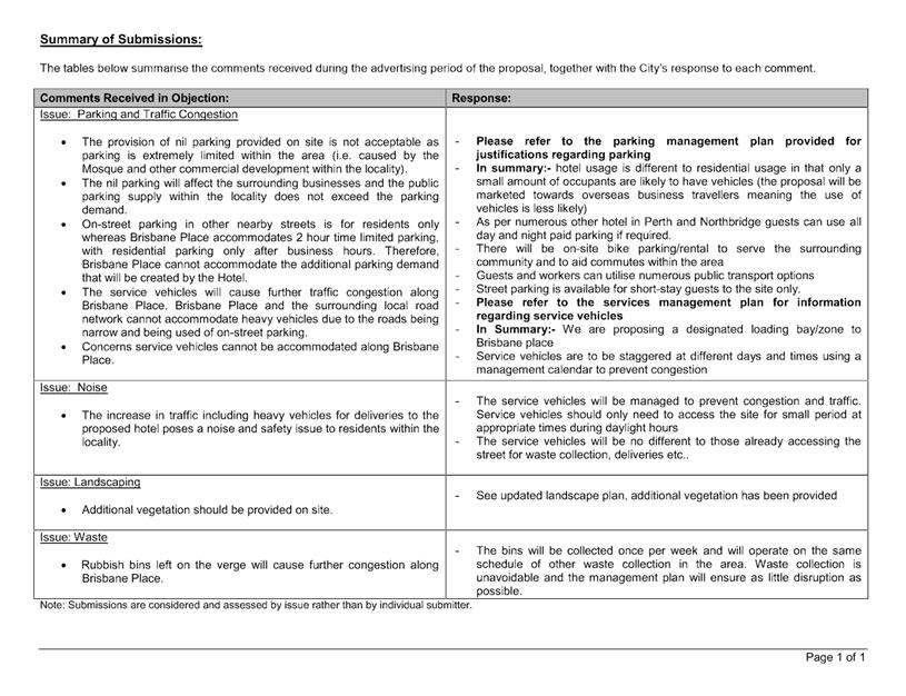
The City received eight submissions; six in objection, one expressing concern and one in support of the proposal. The main issues raised during the consultation related to:
· The impact of overshadowing on the surrounding properties access to natural sun light;
· The impact of the over height boundary wall abutting the southern lot boundary on the amenity of the adjoining property; and
· The impact of the proposed development on the surrounding streetscape.
Following advertising the applicant provided amended plans, with modifications to the plans including:
· Reducing the southern and eastern boundary wall heights which now satisfies the deemed-to-comply requirement of the R Codes;
· Increasing the setback for significant portions of the dwelling from 1.2 metres to 1.5 metres to the southern and eastern lot boundaries;
· Increasing the setback for significant portions of the dwelling from 1.2 metres to 1.5 metres to the eastern lot boundary; and
· Increasing the mature canopy coverage to exceed 30 percent;
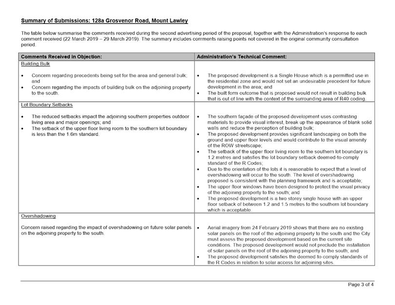
The amended plans were readvertised to the previous submitters for a period of seven days commencing on 22 March 2019 and concluding on 29 March 2019. The City received eight submissions; six in objection, one expressing concern and one in support of the proposal. The objections that were received predominantly reiterated previous concerns raised. A new concern was raised during the consultation period relating to the proposed car parking shortfall and resultant additional vehicles being parked on Dolce Lane and the ROW.
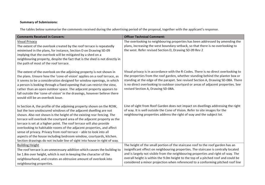
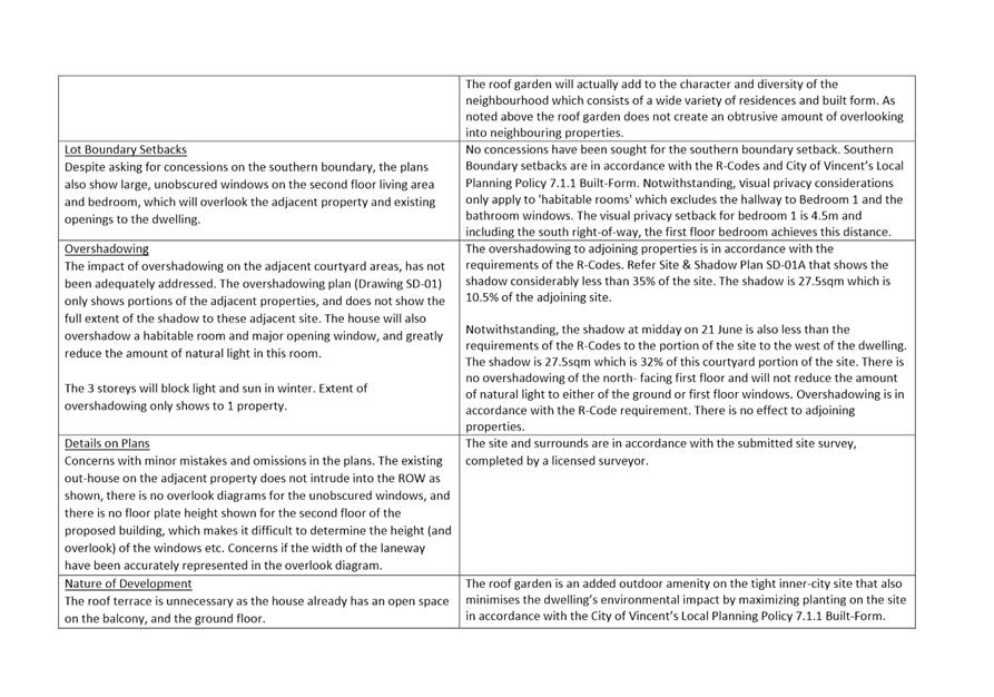
A summary of the submissions received during both rounds of advertising and Administration’s response is provided in Attachment 3. The applicant provided a response to the submissions received during the first round of advertising which is included in Attachment 4.
Design Review Panel (DRP):
Referred to DRP: No
Legal/Policy:
· Planning and Development Act 2005;
· Planning and Development (Local Planning Schemes) Regulations 2015;
· City of Vincent Local Planning Scheme No. 2;
· State Planning Policy 3.1 – Residential Design Codes;
· Policy No. 4.1.5 – Community Consultation; and
· Policy No. 7.1.1 – Built Form Policy.
Should Council refuse the application for development approval, the applicant will have the right to have the decision reviewed in accordance with Part 14 of the Planning and Development Act 2005.
City of Vincent Policy No. 7.1.1 – Built Form
The City has undertaken community consultation for amendments to the existing Built Form Policy. The community consultation period concluded on 11 December 2018.
The development has not been assessed against the proposed amendments to the Built Form Policy. The amendments to the Built Form Policy are in draft form and do not reflect the outcome of any changes stemming from the community consultation period. The amendments to the Built Form Policy are not considered to be ‘seriously entertained’ as they have not received approval from Council following community consultation and they are not certain or imminent in coming into effect in the form they were advertised in.
The amendments to the Built Form Policy are expected to be presented to Council in mid-2019 to consider its acceptability following community consultation.
Delegation to Determine Applications:
This matter is being referred to Council for determination as the proposal has received more than five objections during the City’s community consultation period.
Risk Management Implications:
There are minimal risks to Council and the City’s business function when Council exercises its discretionary power to determine a planning application.
Strategic Implications:
· This is in keeping with the City’s Strategic Community Plan 2018-2028:
Innovative and Accountable
We are open and accountable to an engaged community.
SUSTAINABILITY IMPLICATIONS:
Nil.
Financial/Budget Implications:
Nil.
Comments:
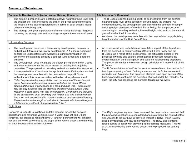
Lot Boundary Setback
Eastern boundary
The R Codes set a 1.8 metre deemed-to-comply setback for the ground floor bedroom 2 ensuite to the eastern lot boundary. A 1.5 metre setback is proposed.
The proposed lot boundary setbacks satisfy the relevant design principles for the following reasons:
· The wall primarily abuts the garage wall of the adjoining property rather than any major openings to habitable rooms or the primary outdoor living area so as to minimise any impact;
· Due to the orientation of the subject site and adjoining property the proposed setback would allow access to adequate direct sunlight to the adjoining eastern properties;
· The development is proposed to be setback sufficiently to allow adequate ventilation for the adjoining property to the east;
· The eastern façade of the proposed dwelling has varying setbacks, glazing and a deep soil area supporting three crepe myrtle’s to moderate the impact of building bulk on the adjoining property;
· The development does not result in any departures from the deemed-to-comply visual privacy requirements of the R Codes in relation to the property to the east; and
· The finished floor level of the existing dwelling to the south is approximately 1.23 metres higher than the proposed dwelling. Whilst the subject wall abuts a major opening to a habitable room on the adjoining property, the proposed development is stepped to follow the natural features of the site and would not result in undue impacts relating to bulk or loss of natural sunlight.
Southern boundary
The R Codes sets a deemed-to-comply setback of 1.6 metres for the upper floor living to kitchen to the southern lot boundary lot boundary. A 1.5 metre setback is proposed.
The proposed lot boundary setback satisfies the relevant design principles for the following reasons:
· The proposed development meets the deemed-to-comply standards of the R Codes in relation to solar access for adjoining sites. The reduced setback would not result in an undue loss of access to direct sunlight to the adjoining property, and the wall is setback from the boundary to maintain ventilation to adjacent buildings;
· The southern façade of the proposed dwelling is articulated with contrasting materials and glazing to moderate the impact of building bulk on the adjoining property; and
· The development does not result in any departures from the deemed-to-comply visual privacy requirements of the R Codes in relation to the property to the south.
Open Space
The R Codes sets a deemed-to-comply standard for open space of 45 percent of the site area for properties with an R40 density coding. A total of 43.2 percent of site is proposed to be open space.
The proposed open space satisfies the relevant design principles for the following reasons:
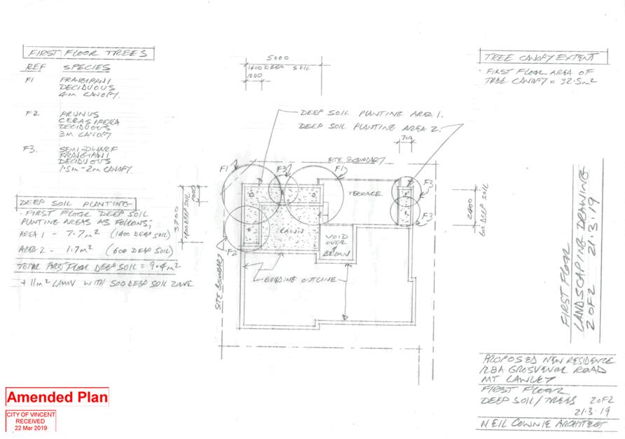
· The dwelling provides the primary outdoor living area on the upper floor abutting the northern lot boundary which incorporates significant landscaping, including a 20 square metres landscaped area, supporting three frangipani trees and a deep soil planter along the eastern side of the terrace supporting two dwarf frangipani trees. While not considered as open space for the purposes of the R Codes definition this would function as an area that can be utilised for outdoor pursuits and if counted the site would have well over 45 percent open space;
· The development is consistent with the established streetscape as the development has provided for the ROW widening and is setback appropriately from the ROW;
· The dwelling façade provides visual interest and articulation with the use of timber cladding to the upper floor, face brick walls and concrete planters;
· The built form outcome is consistent with the density outcome dictated by the R40 density coding and is not an overdevelopment of the site with regard to bulk and scale;
· The proposed dwelling exceeds the R Codes requirements for covered and uncovered outdoor living areas and provides ample opportunity for occupants of the dwelling to undertake outdoor pursuits; and
· The development complies with the Built Form Policy requirements for landscaping through the provision of deep soil zones and mature tree canopy areas.
Outdoor Living Area
The R Codes sets a deemed-to-comply minimum dimension for outdoor living areas of 4.0 metres. A minimum dimension of 2.8 metres is proposed.
The proposed outdoor living area satisfies the relevant design principles for the following reasons:
· The outdoor living area is open to the northern aspect and provides adequate access to winter sun;
· The outdoor living area is capable of use in conjunction with the upper floor living and dining rooms of the dwelling; and
· The 25.7 square metre total outdoor living area size exceeds the 20 square metre deemed-to-comply standard and provides a functional space for outdoor pursuits.
Landscaping
In addition to the deemed-to-comply requirements of the R Codes, the application has also been assessed against the landscaping provisions of Clause 5.14 of the Built Form Policy that proposes replacement deemed-to-comply standards to those included in the R Codes. The deemed-to-comply landscaping standards set out in the Built Form Policy have not yet been approved by the WAPC and as such, these provisions are given due regard in the assessment of the application.
The Built Form Policy sets a deemed-to-comply standard of 15 percent of the site area as deep soil zone and 30 percent of the site area as canopy coverage at maturity. The application proposes 24.8 percent of the site area as deep soil zone and 31.1 percent canopy coverage at maturity. The application proposes trees within the lot boundary and ROW setback areas which would create the sense of open space between buildings and present an appropriate landscaping outcome to the streetscape and for residents. The application proposes trees within the upper floor outdoor living area which would provide depth and visual interest as viewed from the streetscape and adjoining properties. The proposal results in an overall increase in canopy across the site from what currently exists and positively contributes to the use and activation of the ROW.
Privacy
The R Codes sets a deemed-to-comply setback of 7.5 metres from upper floor terraces and balconies to site boundaries. The application proposes a setback of 7.1 metres from the upper floor terrace to the northern lot boundary across the right of way.
The proposed overlooking is consistent with the design principles for the following reasons:
· The upper floor terrace looks in the direction of the parking area and minor openings on the ground and upper floors of the adjoining property at No. 101A Raglan Road. The departure from the deemed-to-comply standard does not have an adverse impact on any major openings to habitable rooms or the primary outdoor living area;
· Whilst the upper floor terrace does look in the direction of the adjoining properties upper floor roof deck, there is approximately a 10.7 metre separation between the two and the angle of view is oblique rather than direct; and
· The proposed visual privacy variation was advertised to the adjoining property owner to the north at No.101A Raglan Road and no objection was received.
Parking & Access
The R Codes deemed-to-comply standard is for the development to provide two on-site car parking spaces. One on-site car parking space is proposed.
The parking proposed is consistent with the design principles for the following reasons:
· Although the site is not located within 250 metres of a “high frequency bus route” as defined in the R Codes, it is well serviced by accessible public transport options. The site is located approximately 290 metres from William Street and approximately 400 metres from Fitzgerald Street which are both ‘high frequency bus routes’ in accordance with the R Codes. If the site was located within 250 metres of one of these routes the development would meet the deemed-to-comply standard under the R Codes as the number of bays necessary reduces to one bay;
· There are accessible on-street parking options along the Grosvenor Road verge area between Fitzgerald Street and Beaufort Street which are able to be utilised by occupants and visitors of the subject site. The City’s parking survey data identifies that the usage of the on-street parking along Grosvenor Street between Fitzgerald Street and Beaufort Street did not exceed 38% of capacity during the study times; and
· One car space is appropriate for the proposed development, being a Single House with an internal floor area of only 134 square metres.
The R Codes deemed-to-comply standard is for driveways to be no closer than 6.0 metres to the street corner. The proposed vehicle access point is not setback from the corner of Dolce Lane and the ROW.
The proposed vehicle access configuration is consistent with the design principles for the following reasons:
· The development proposes an unenclosed parking space parallel to Dolce Lane which is a similar design to the approved dwelling to the north at No.101A Raglan Road;
· Dolce Lane and the ROW are low speed carriageways and the proposal would not result in an unsafe vehicle access point;
· The proposed parking area is unenclosed on the Dolce Lane boundary and the development proposes high quality landscaping, both of these design features would reduce the impact of the vehicle access point on the streetscape;
· The development proposes one vehicle access point to the site only; and
· The application has been assessed by the City’s development engineers and it has been confirmed that one parallel parking space with a length of 6.6 metres is acceptable in the proposed location.
TRIM Ref: D19/23504
Author: Natasha Trefry, Urban Planning Advisor
Authoriser: John Corbellini, Executive Director Development Services
Ward: South
Attachments: 1. Attachment
1 - Consultation and Location Plan ⇩ ![]()
2. Attachment 2 -
Development Plans ⇩ ![]()
3. Attachment 3 -
Summary of Submissions and Administrations Comment ⇩ ![]()
4. Attachment 4 - Summary
of Submissions and Applicant Comments ⇩ ![]()
5. Attachment 5 -
Additional Justification from Applicant ⇩ ![]()
6. Attachment 6 -
Determination Advice Notes ⇩ ![]()
7. Attachment 7 -
Justification from Applicant Regarding Right of Way (ROW) Widening Areas ⇩ ![]()
|
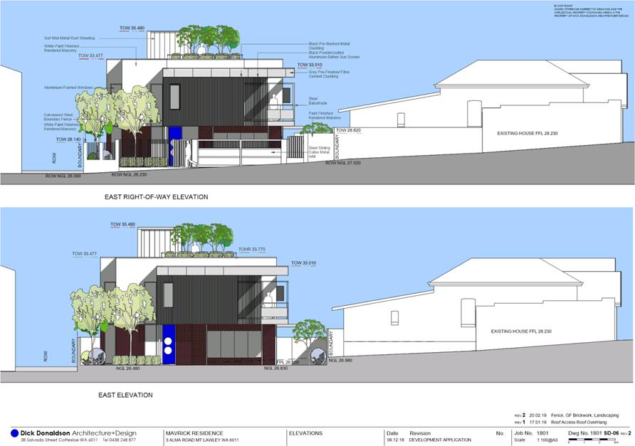
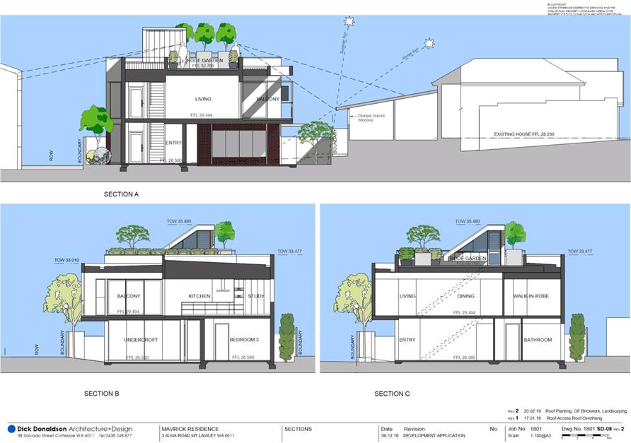
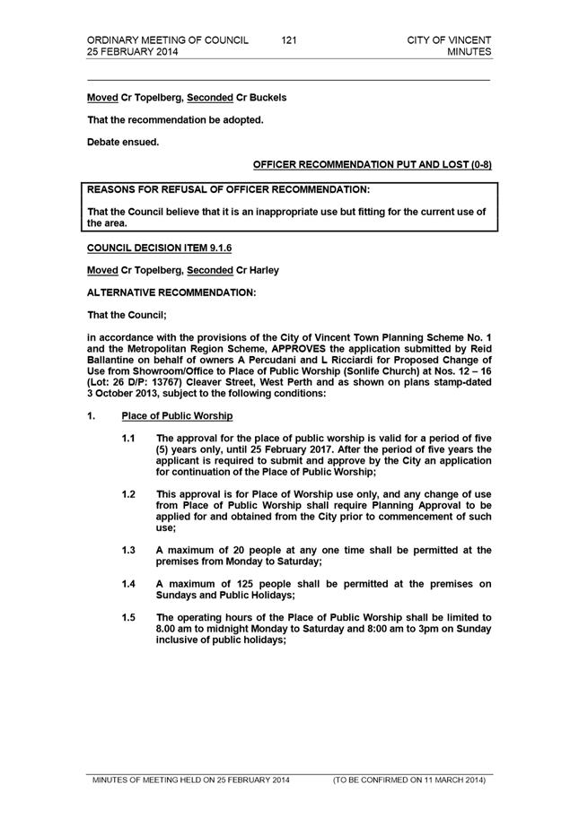
That Council, in accordance with the provisions of the City of Vincent Local Planning Scheme No.2 and the Metropolitan Region Scheme, APPROVES, the development application for a Grouped Dwelling at No. 3 (Lot: 43; D/P: 1237) Alma Road, Mount Lawley in accordance with the plans in Attachment 2, subject to the following conditions, with the associated advice notes in Attachment 6: 1. External Fixtures All external fixtures and building plant, including air conditioning units, piping, ducting and water tanks, shall be located so as to minimise any visual and noise impact on surrounding landowners, and screened from view from the street, and surrounding properties to the satisfaction of the City; 2. Stormwater All stormwater produced on the subject land shall be retained on site, by suitable means to the full satisfaction of the City; 3. Schedule of External Finishes Prior to the commencement of development a detailed schedule of external finishes (including materials and colour schemes and details) shall be submitted to and approved by the City. The development shall be finished in accordance with the approved schedule prior to the use or occupation of the development; 4. Landscape Plan 4.1 A detailed landscape and reticulation plan for the development site and adjoining road verge, to the satisfaction of the City, shall be lodged with and approved by the City prior to commencement of the development. The plan shall be drawn to a scale of 1:100 and show the following: · The location and type of existing and proposed trees and plants; · Areas to be irrigated or reticulated; and · The provision of 15 per cent of the site area as deep soil zone and 30 per cent canopy cover at maturity; and 4.2 All works shown in the plans as identified in condition 4.1 above shall be undertaken in accordance with the approved plans to the City’s satisfaction, prior to occupation or use of the development and shall be maintained thereafter to the satisfaction of the City at the expense of the owners/occupiers; 5. Street Walls and Fences The infill panels of the front fencing shall be ‘visually permeable’, as defined by State Planning policy 3.1; Residential Design Codes, to the satisfaction of the City; 6. Screening 6.1 The ‘Black Powdercoated Aluminium Batten Sun Screen’ shown for a portion of the eastern side of the ‘Balcony’ shall meet the definition of ‘screening’ as defined by State Planning Policy 3.1: Residential Design Codes to the satisfaction of the City. The screening shall be a minimum height of 1.6 metres from the finished floor level, permanently affixed and a minimum of 75 percent obscure to the satisfaction of the City; 6.2 Screening shall be provided to the western side of the ‘Balcony’ and shall meet the definition of ‘screening’ as defined by State Planning Policy 3.1: Residential Design Codes to the satisfaction of the City. The screening shall be a minimum height of 1.6 metres from the finished floor level, permanently affixed and a minimum of 75 percent obscure to the satisfaction of the City; 6.3 The major opening from the kitchen shall be permanently fixed to at least 1.6 metres in height measured from the finished floor level, or shall be modified to be a non-major opening, to comply with the deemed-to-comply Visual Privacy standards of Clause 5.4.1 of State Planning Policy 3.1: Residential Design Codes to the satisfaction of the City; and 6.4 Fixed planter boxes no less than 500 millimetres wide and 800 millimetres deep shall be provided on the roof terrace along the whole extent of the western length to the satisfaction of the City. Plantings within the planter boxes are to be no less than 800 millimetres high at maturity and provide a continuous screen of foliage across the length of the terrace; and 7. Right Of Way (ROW) Widening 7.1 Prior to the commencement of development, the applicant shall lodge a modified plan with the City providing a 0.5 metre setback to the southern ROW, a 1.0 metre setback to the eastern ROW and a 2.0 metre by 2.0 metre truncation setback between the southern and eastern ROW setback areas from any building or structure to enable future ROW widening, to the satisfaction of the City. The modified plan shall show the proposed Galvanised Steel and Rendered Masonry Boundary Fence relocated outside of the setback area, to the satisfaction of the City; 7.2 The 0.5 metre setback to the southern ROW, 1.0 metre setback to the eastern ROW and 2.0 metre by 2.0 metre truncation setback between the southern and eastern ROW setback areas referred to in condition 7.1 above shall be sealed, drained and graded to match into the level of the existing ROW to the satisfaction of the City, prior to the occupation or use of the development; and 7.3 The 0.5 metre setback to the southern ROW, 1.0 metre setback to the eastern ROW and 2.0 metre by 2.0 metre truncation setback between the southern and eastern ROW setback areas referred to in condition 7.1 above, shall be ceded free of cost to the City on subdivision or amalgamation of the land, including Built Strata subdivision. |
Purpose of Report:
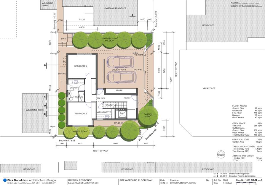
To consider an application for development approval for a grouped dwelling at No. 3 Alma Road, Mount Lawley (subject site).
PROPOSAL:
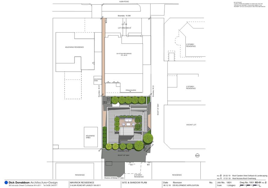
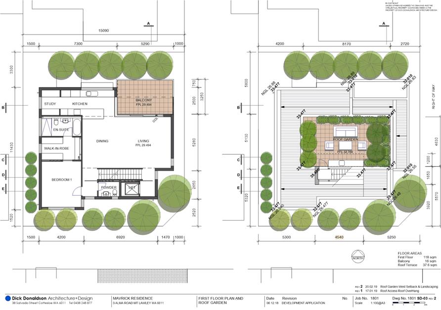
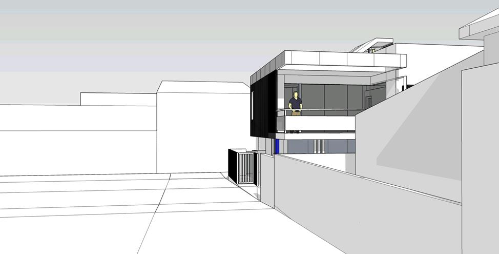
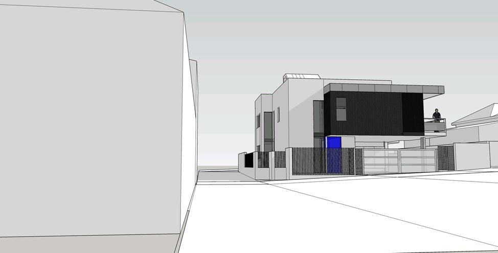
The application proposes a three storey grouped dwelling to the rear of an existing single house that is proposed to be retained as a grouped dwelling. The third storey element of the dwelling comprises a central covered stairwell to an uncovered roof terrace only.
Background:
|
Landowner: |
Milton Mavrick, Lynne Mavrick, Jack Hobbs and Ella Hobbs |
|
Applicant: |
Dick Donaldson Architecture and Design |
|
Date of Application: |
06 December 2018 |
|
Zoning: |
MRS: Urban LPS2: Residential R Code: R30 |
|
Built Form Area: |
Residential |
|
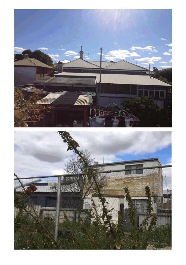
Existing Land Use: |
Single House |
|
Proposed Use Class: |
Grouped Dwelling |
|
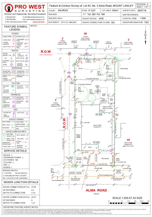
Lot Area: |
Total – 604m² Subject Lot – 266m² |
|
Right of Way (ROW): |
Yes Southern 3.82m wide, sealed and owned by City Eastern 4.02m to 5.0m wide, sealed and owned by City |
|
Heritage List: |
No |
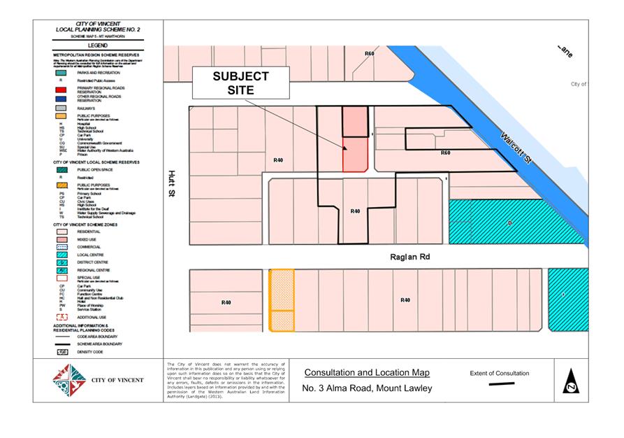
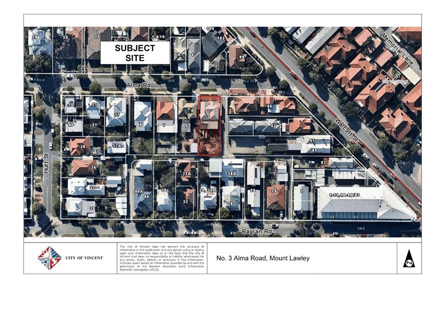
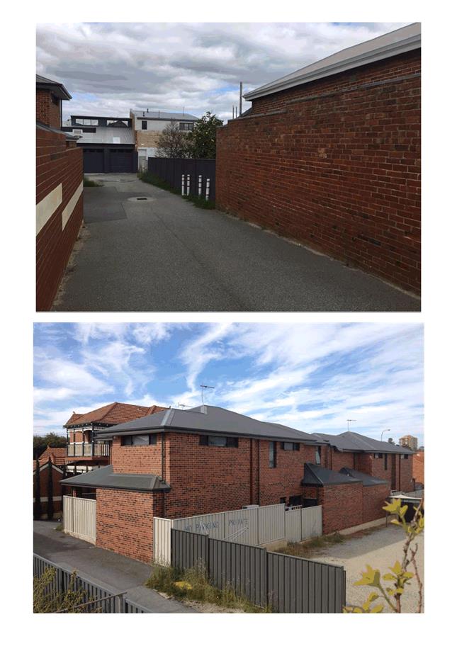
The subject site is bound by Alma Road to the north, a single storey single house to the west and a ROW to the east and south. A location plan is included as Attachment 1.
The surrounding residential developments to Alma Road and the adjacent ROW are single-storey and two-storey single houses. The subject site and adjoining properties are zoned Residential, with the subject properties and area to the south and east being coded R40 and the area to the north and west being coded R60. The area forms part of the Residential Built Form area in accordance with the City’s Policy No. 7.7.1 – Built Form. The site currently accommodates a single storey single house with a street interface to Alma Road.
The application proposes an additional dwelling be located at the rear of the existing property, which is accessible via two existing ROWs which border the southern and eastern boundaries of the site. The development plans have been included as Attachment 2.
Details:
Summary Assessment
The table below summarises the planning assessment of the proposal against the provisions of the City of Vincent Local Planning Scheme No. 2 (LPS2), the City’s Policy No. 7.1.1 – Built Form and the State Government’s Residential Design Codes. In each instance where the proposal requires the discretion of Council, the relevant planning element is discussed in the Detailed Assessment section following from this table.
|
Planning Element |
Use Permissibility/ Deemed-to-Comply |
Requires the Discretion of Council |
|
Street Setback |
ü |
|
|
Front Fence |
|
ü |
|
Building Setbacks/Boundary Wall |
|
ü |
|
Building Height/Storeys |
|
ü |
|
Open Space |
ü |
|
|
Outdoor Living Areas |
ü |
|
|
Landscaping |
ü |
|
|
Privacy |
|
ü |
|
Parking & Access |
ü |
|
|
Solar Access |
ü |
|
|
Site Works/Retaining Walls |
ü |
|
|
Essential Facilities |
|
ü |
|
External Fixtures |
ü |
|
|
Surveillance |
ü |
|
|
Pedestrian Access Way |
|
ü |
|
Outbuildings |
ü |
|
|
Development on Rights of Way |
|
ü |
Detailed Assessment
The deemed-to-comply assessment of the element that requires the discretion of Council is as follows:
|
Lot Boundary Setbacks |
|
|
Deemed-to-Comply Standard |
Proposal |
|
Clause 5.1.3 of the R Codes
North Boundary: Upper Floor: Balcony – 3.0m
Western Boundary: Upper Floor: Bedroom 1 to Study – 1.6m |
North Boundary: Upper Floor: Balcony – 2.5m
Western Boundary: Upper Floor: Bedroom 1 to Study – 1.5m |
|
Street Walls and Fences |
|
|
Deemed-to-Comply Standard |
Proposal |
|
Clause 5.10 of Built Form Policy
Eastern Boundary Maximum pier height – 1.8m or 2.0m with capping detail Maximum height of solid portion of wall – 1.2m
Southern Boundary Maximum height of solid wall – 1.8m |
2.1m pier height with no capping
Solid portion of wall – 1.9m
Solid wall to 2.1m |
|
Visual Privacy |
|
|
Deemed-to-Comply Standard |
Proposal |
|
Clause 5.4.1 of the R Codes
Minimum setback of major openings to habitable rooms other than bedrooms and studies from property boundary – 6.0m
Minimum setback of unenclosed outdoor active habitable spaces from property boundary – 7.5 |
Kitchen Setback from northern property boundary: 3.3m
Balcony Setback from northern property boundary: 2.5m Setback from eastern property boundary: 1.0m
Terrace Setback from northern property boundary: 6.1m Setback from eastern property boundary: 6.7m Setback from western property boundary: 4.2m |
|
Building Height |
|
|
Deemed-to-Comply Standard |
Proposal |
|
Clause 5.6 of Built Form Policy
2 storey building height
Maximum Height of Concealed Roof – 7.0m |
3 storey building height (third storey consists of enclosed staircase to terrace only)
Height of Concealed Roof – 8.8m |
|
Essential Facilities |
|
|
Deemed to Comply |
Proposal |
|
Clause 5.4.1 of the R Codes
An enclosed lockable storage area, constructed in a design and material matching the dwelling where visible from the street, accessible from outside the dwelling, with a minimum dimension of 1.5m where provided external to the garage and 1m where provided within a garage and an internal area of at least 4 square metres, for each grouped dwelling. |
Store 1 (external) : 3.3 square metres
Store 2 (internal): 3.5 square metres |
|
Pedestrian Access Way |
|
|
Deemed-to-Comply Standard |
Proposal |
|
Clause 5.31 of Built Form Policy
Minimum 1.5m wide pedestrian access way |
0.9 metre wide pedestrian access way |
|
Development on Rights of Way |
|
|
Deemed-to-Comply Standard |
Proposal |
|
Clause 5.31 of Built Form Policy
Development setback 1.0m from a ROW or future right-of-way widening. |
Eastern Boundary Ground Floor: 1.47m Upper Floor: 0m
Southern Boundary Ground Floor: 0.43m Upper Floor: 0.43m |
|
Right of Way Widening |
|
|
Deemed-to-Comply Standard |
Proposal |
|
Western Australian Planning Commission: Planning Bulletin 33: Rights of Ways or Laneways in Established Areas
ROW Widening to provide a ROW width of 6.0 metres Eastern Boundary: 1.0m widening Southern Boundary: 1.09m widening |
No ROW widening proposed. |
The above elements of the proposal do not meet the specified deemed-to-comply standards and are discussed in the comments section below.
Consultation/Advertising:
Community Consultation was undertaken in accordance with the Planning and Development (Local Planning Scheme) Regulations 2015, for a period of 14 days commencing on 1 February 2019 to 14 February 2019. Community consultation was undertaken by means of written notifications being sent to surrounding landowners, as shown in Attachment 1 and a notice on the City’s website. At the conclusion of the community consultation period, three submissions, including two objections and one support were received by the City. The main issues raised as part of the consultation relate to the following:
· Visual privacy from the roof terrace to adjoining properties;
· Overshadowing from the dwelling and corresponding roof terrace to adjoining properties;
· Height of dwelling impacting access to light and sun for neighbouring properties; and
· Roof terrace proposes unnecessary scale of development and development that is out of character with the area.
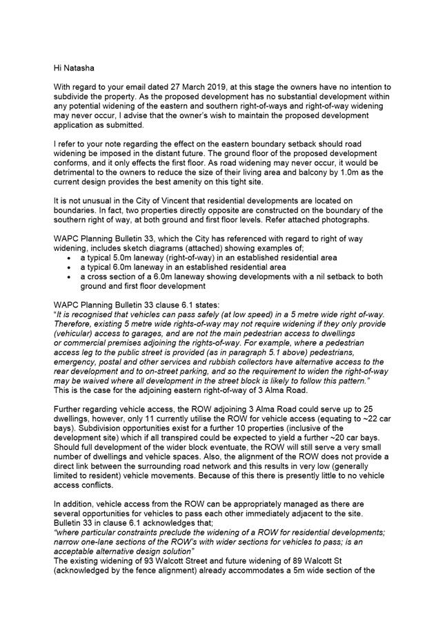
A summary of the submissions and Administration’s comments on each issue is included as Attachment 3, with the applicants response to submissions included as Attachment 4. Following the advertising period, the applicant amended the development proposal by modifying the design and materials of the façade, reducing the size of the roof terrace and providing additional landscaping. The additional justification provided with the amended plans in regards to the visual privacy from the roof terrace are noted in Attachment 5. The applicants have also provided justification in regards to the 0.5 metre and 1.0 metre ROW widening areas requested by the City to the eastern and southern elevations, comments and justification from the applicants is provided as Attachment 7.
Design Review Panel (DRP):
Referred to DRP: No
Legal/Policy:
· Planning and Development Act 2005;
· Planning and Development (Local Planning Schemes) Regulations 2015;
· City of Vincent Local Planning Scheme No. 2;
· State Planning Policy 3.1 – Residential Design Codes;
· Policy No. 4.1.5 – Community Consultation; and
· Policy No. 7.1.1 – Built Form Policy.
The deemed-to-comply landscaping standards set out in the Built Form Policy have not yet been approved by the Western Australian Planning Commission (WAPC), who have instead issued approval for a modified set of deemed-to-comply landscaping standards that are similar to those set out in Design WA but which have not yet been approved by Council. As a result the assessment shall only have due regard to those deemed-to-comply landscaping standards approved by Council in the Built Form Policy.
Delegation to Determine Applications:
The matter being referred to Council as the application proposes a height of three storeys or more.
Risk Management Implications:
There are minimal risks to Council and the City’s business functions when Council exercises its discretionary power to determine a planning application.
Strategic Implications:
The City’s Strategic Plan 2013-2023 states:
Innovative and Accountable
“We are open and accountable to an engaged community.”
SUSTAINABILITY IMPLICATIONS:
Nil.
Financial/Budget Implications:
Nil.
Comments:
Lot Boundary Setbacks
Northern Boundary
The application involves an upper floor setback of 2.5 metres from the balcony (located to the front of the property) to the northern boundary in lieu of 3.0 metre deemed-to-comply setback set by the R Codes. The proposed setback meets the relevant design principles for the following reasons:
· The majority of the northern façade is open, with an open carport on the ground floor and an open cantilevered balcony above. This articulates the north façade and reduces the bulk of the development on the existing dwelling to the north.
· The third storey is located centrally to the building and 6.1 metres from the northern site boundary, largely screening this element of the development from the existing dwelling to the north.
· The balcony wraps around the north western corner of the building, providing an articulated and open facade when viewed from the street and dwelling facing Alma Road.
· The proposal incorporates landscaping along the lot boundary of the site to further soften the building edge.
Western Boundary
The application involves an upper floor setback of 1.5 metres from the western façade to the western boundary in lieu of the 1.6 metre deemed-to-comply setback set under the R Codes. The proposed setback meets the relevant design principles for the following reasons:
· The proposed dwelling is adjacent to a shed and clothes drying area of the adjoining property to the west.
· The dwelling only extends for 11.43 metres adjacent to the extended rear yard of the adjoining property and the 1.5 metre setback proposed provides an adequate separation for this upper floor from the property boundary.
· The application proposes a tall hedge along the southern half of the western boundary, which would mitigate the bulk and scale of the development.
· Major openings to the western boundary meet the deemed to comply requirements in regards to visual privacy, and the reduced lot boundary setback does not exacerbate impacts of visual privacy on the adjacent property. The proposed setback does not result in an adverse impact on the neighbouring property in terms of privacy.
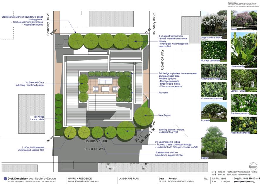
Landscaping
The landscaping proposed satisfies the existing deemed-to-comply landscaping standards set by the R Codes. The application proposes 19.5 percent of the site area as deep soil zones and a canopy coverage of 59.5 percent of the site area at maturity, satisfying the deemed-to-comply landscaping standards set in the City’s Built Form Policy.
Building Height
The application proposes three storeys and a maximum height of 8.8 metres to the top of the concealed roof in lieu of the two storey and maximum concealed roof height of 7.0 metres set as a deemed-to-comply standard in the City’s Built Form Policy. The building height proposed satisfies the relevant design principles and local housing objectives of the R Codes and Built Form Policy and is acceptable for the following reasons:
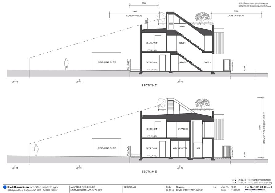
· The third storey and maximum height applies only to the centrally located stairwell roof, which provides access to the roof terrace.
· The central location of the stairwell means that the portion of the stairwell roof is largely not visible from neighbouring properties or adjacent ROW and does not add bulk and scale to the development.
· The slope of the lot from north to south (front to rear) means the proposed dwelling to the rear sits lower than the retained dwelling and does not impact on the established Alma Road streetscape character.
· The maximum wall height of the proposed development complies with the deemed-to-comply standards and does not exceed a height of 7.0 metres.
· The central location of the stairwell means that this third storey does not add to overshadowing of adjoining properties. The overshadowing proposed meets the deemed-to-comply standards of the R Codes.
· The finished floor levels proposed have been stepped in line with the natural ground levels of the site, to ensure a reduced overall height for the building. The development considers and responds to the natural slope with minimal fill and excavation required.
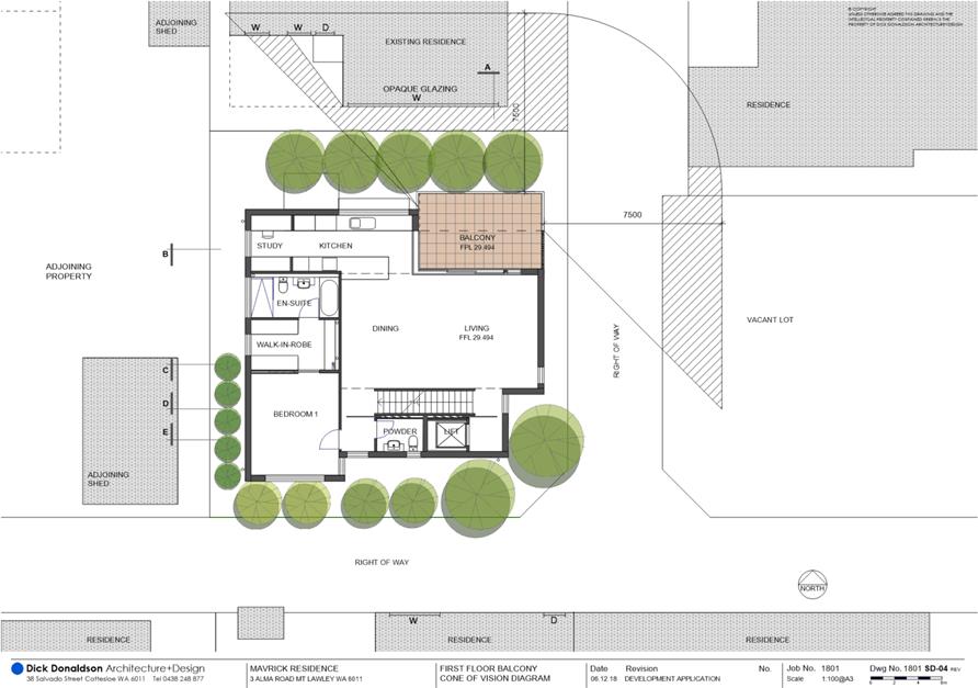
Visual Privacy
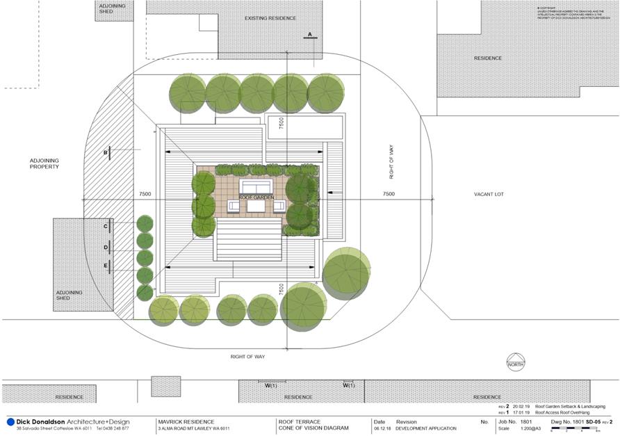
Roof Terrace to Western Boundary
The setback of the roof terrace to the western property boundary is 4.2 metres in lieu of the minimum setback of 7.5 metres set as a deemed-to-comply standard in the R Codes. The visual privacy from the roof terrace to the adjacent western property satisfies the relevant design principles and local housing objectives of the R Codes and Built Form Policy and is acceptable for the following reasons:
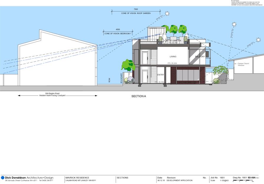
· While the horizontal cone of vision falls over the adjacent property’s shed and clothes drying area, the vertical cone of vision does not fall over any part of this property given the planters shown on the roof terrace would screen the view below (see sections D and E included in Attachment 5). It is recommended that any approval be conditioned to require these planters to be fixed so that there is no overlooking to No. 5 Alma Road from usable space on the roof terrace.
· The overlooking to No. 7 Alma Road falls well outside of the 7.5 metre cone of vision.
Roof Terrace to Northern Boundary
The setback of the roof terrace to the northern property boundary is 6.1 metres in lieu of the minimum setback of 7.5 metres set as a deemed-to-comply standard in the R Codes. The visual privacy from the roof terrace to the adjacent northern site satisfies the relevant design principles and local housing objectives of the R Codes and Built Form Policy and is acceptable for the following reasons:
· The cone of vision falls over the southern wall of the existing dwelling to the north, which includes opaque windows only.
· The owner of the northern dwelling has consented to the proposed overlooking.
· While the vertical cone of vision falls over the northern dwelling’s outdoor living area, the horizontal cone of vision does not fall over this area given the roof terrace is setback from the second storey roof, which would screen any view down to the northern property (see Section A included in Attachment 5). Any overlooking from the northern elevation falls to the roofline of the existing dwelling, as noted in Attachment 5, Section A. The cone of vision does not look to areas of open space or active habitable spaces of the adjacent property, and as such the visual privacy from the northern elevation is supported.
Roof Terrace to Eastern Boundary
The setback of the roof terrace to the eastern property boundary is 6.7 metres in lieu of the minimum setback of 7.5 metres set as a deemed-to-comply standard in the R Codes. The visual privacy from the roof terrace to the adjacent eastern properties satisfies the relevant design principles and local housing objectives of the R Codes and Built Form Policy and is acceptable for the following reasons:
· The cone of vision to the east is to the ROW and portion of a vacant lot.
· Any development of this vacant lot would likely require a setback to accommodate the ROW widening. The cone of vision would then fall entirely within the ROW.
Kitchen to Northern Boundary
The setback of the kitchen window to the eastern property boundary is 3.3 metres in lieu of the minimum setback of 6.0 metres set as a deemed-to-comply standard in the R Codes. The visual privacy from the kitchen window to the adjacent property does not satisfy the relevant design principles of the R Codes for the following reasons:
· While the owner of the northern dwelling has consented to the proposed overlooking, the cone of vision from the kitchen window fall over the only outdoor living area of the adjacent property.
· The overlooking into the northern dwelling’s outdoor living area is not screened or obscured by the existing dwelling.
Administration recommends the imposition of a condition to modify the proposed kitchen window so that it is either a highlight window or full obscured, such that the window meets the deemed-to-comply visual privacy standards of the R Codes.
Balcony to Northern Boundary
The setback of the balcony to the northern property boundary is 2.5 metres in lieu of the minimum setback of 6.0 metres set as a deemed-to-comply standard in the R Codes. The visual privacy from the balcony to the adjacent property satisfies the relevant design principles and local housing objectives of the R Codes and Built Form Policy and is acceptable for the following reasons:
· The cone of vision falls over the southern wall of the existing dwelling to the north, which includes only opaque windows.
· The owner of the northern dwelling has consented to the proposed overlooking.
· Screening is provided to the balcony via five Lagerstroemia Indicus trees. Providing a canopy of approximately 93 square metres at maturity, the trees at maturity would block some vision to the adjacent property. In addition, the applicant proposes stainless steel wiring to assist in trailing plants, to enhance the natural screen along the boundary.
· The cone of vision from the balcony partially falls over the only outdoor living area to the existing dwelling at 3 Alma Road. It is recommended that a condition be imposed requiring the balcony be screened along the short section of the western edge so that no part of the cone of vision falls over this outdoor living area.
Balcony to Eastern Boundary
The 6.0 metre cone of vision from the proposed balcony projects 1 metre into the adjoining properties located on the opposite side of the ROW to the east. The deemed-to-comply standard of the R Codes requires the 6.0 metre cone of vision not to project into any part of any other residential property. The visual privacy from the balcony to the adjacent property satisfies the relevant design principles and local housing objectives of the R Codes and Built Form Policy and is acceptable for the following reasons:
· A sun screen to the eastern balcony elevation provides a perceived barrier and screening for the cone of vision which extends into the ROW.
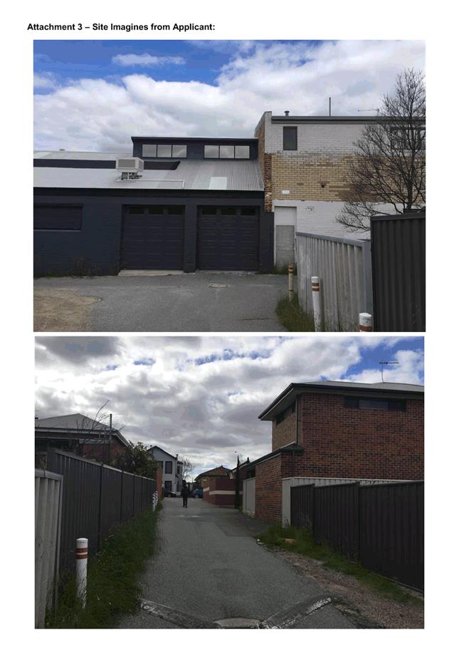
· The cone of vision to the east falls into the vacant lot area at the rear of Nos. 89-91 Walcott Street, and as a non-active habitable space or outdoor living area for the subject dwelling, is not subject to the deemed to comply requirements, and is not noted to be out of line with the deemed to comply requirements. The boundary wall to No. 93 Walcott Street is blank and does not include any major openings which could be viewed from the cone of vision from the balcony.
· The balcony provides street surveillance to the ROW as well as a line of sight to Alma Road. The balcony aids in the proposed dwelling maintaining an active and interactive frontage.
Street Walls & Fences
The application proposes front fencing along the eastern and southern boundaries with the ROW. The fencing to the eastern ROW incorporates a maximum pier height of 2.1 metres in lieu of 1.8 metres set as a deemed-to-comply standard in the City’s Built Form Policy. The fence is also solid for a section along both the eastern and southern boundaries to a maximum height 2.1 metres in height rather than being visually permeable above 1.2 metres in height, which is the deemed-to-comply standard in the Built Form Policy. The front fences proposed satisfy the relevant design principles and local housing objectives of the R Codes and Built Form Policy and are acceptable for the following reasons:
· The pier height above 1.8 metres is proposed as a result of the natural slope of the site.
· The height of the piers is not visually dominant on the streetscape, particularly given all other aspects of the fence comply and is generally consistent with a 1.8 metre pier height and ensure a consistent fence height along the eastern boundary.
· The street fence, which includes a vehicle access gate and pedestrian gate, meets all other requirements of the City’s Built Form Policy, with the fence being solid to 0.9 metres above the footpath level and the vehicle gate being visually permeable above 1.2 metres.
· The proposed development fronts the ROW, consistent with the design intent to enhance the visual character of the ROW and consider the relationship between the private and public domain.
· The 1.9 metre solid portion of wall on the eastern elevation provides visual privacy to the primary outdoor living area on the ground floor. The wall does not impact sight lines or street surveillance to the property and is considered appropriate for the lot.
· The solid portion of fence along the southern boundary occurs for approximately half the length of the boundary, with the remaining portion of fence being visually permeable above 1.2 metres. The solid portion of wall provides privacy to the ground floor bedroom 2.
· The fences are compliant with the visual truncations and sight lines requirements of the R Codes and is safe for both pedestrians and users of the ROW.
· The permeability of the fence allows for surveillance of the ROW. The dwelling also maintains street surveillance via its entry and major openings on the ground and upper storeys.
Essential Facilities
The development proposes two store room areas, internal and external to the dwelling. The external store does not meet the minimum four square metre requirements. External to the dwelling, contained within the vehicle access area the store is 3.3 square metres, and unenclosed. The internal store area, integrated with the staircase in the entry, is a 3.5 square metre area. The proposed store area satisfies the relevant design principles and local housing objectives of the R Codes and Built Form Policy and is acceptable for the following reasons:
· The store room in integrated into the dwelling, constructed of the same brick and render finish as the dwelling.
· The storage area enclosed behind a vehicle access gate which provides additional security and serves as a lockable measure for the store.
· The external store is easily accessible from the open space of the dwelling and is considered to be in a location that is convenient for the residents.
· The external store area is not visible from the street, and does not detract from the dwelling or the ROW built form.
Pedestrian Access Way Width
The proposed development includes a pedestrian access way along the western boundary with a minimum width of 0.9 metres in lieu of 1.5 metre minimum width set by the R Codes. The proposed pedestrian access way satisfies the relevant design principles and local housing objectives of the R Codes and Built Form Policy and is acceptable for the following reasons:
· The 0.9 metre width is sufficient for pedestrian and rubbish bin access.
· Pedestrian access to the new dwelling would predominantly be via the eastern ROW.
· The pedestrian access way width is 1.5 metres at the Alma Road end and reduces to a 0.9 metres along the boundary of the existing dwelling. The 1.5 metres provided at the Alma Road interface provides sufficient space to manoeuvre and manage waste, as well as providing suitable spaces for services.
· The proposed pedestrian access way width of 0.9 metres allow for the retention of the existing character dwelling.
· The Department of Planning, Lands and Heritage (DPLH) has indicated its general support for the proposal and cited other situations where a 0.9 metre setback has been supported, where the site is constrained and an existing dwelling is retained.
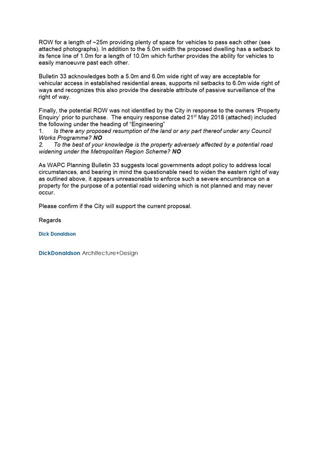
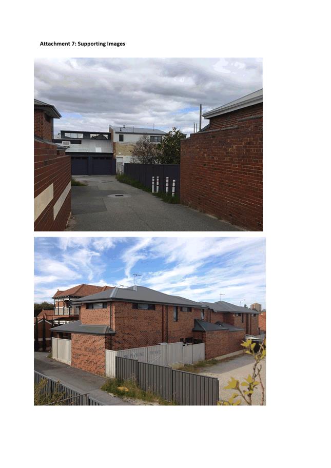
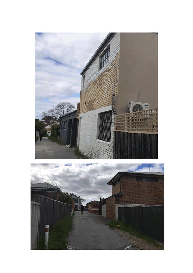
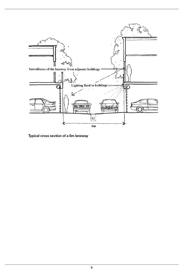
Developments on Rights of Way
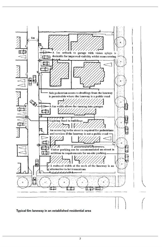
The proposed development is subject to two ROW widenings in accordance with the Built Form Policy and the Western Australian Planning Commission’s Planning Bulletin 33: Rights of way or laneways in established areas (PB33). The current ROWs that border the site to the south and east are 3.82 metres and 4.02 to 5.0 metres in width, respectively. The 6.0 metre ROW width standard included in PB33 would require a widening of 1.0 metres to be provided along the eastern boundary and 1.09 metres along the southern boundary. The development has been set back outside of the ROW widening area, but the application has not indicated any ROW widening and the applicant has not proposed to provide such widening.
Eastern ROW
PB33 sets a deemed-to-comply ROW width of 6.0 metre for all ROWs to ensure appropriate space is available to manoeuvre a car in or out of a garage, carport or parking space at right angles to the ROW. Car parking on the subject lot is accessed from the eastern boundary, and the 1.0 metre widening on the eastern side of the lot is considered necessary to provide adequate manoeuvring for vehicles to and from this car parking area. The provision of a 1.0 metre widening on the eastern side is consistent with the widening that has been required directly opposite the subject site on the eastern side of this ROW and would ultimately facilitate the delivery of a 6.0 metre wide laneway adjoining the subject site.
The widening does not impact on any active open space and can be accommodated within the currently proposed development design by pushing the minor section of front fencing proposed either side of the driveway back to the ROW widening alignment. It is recommended that a condition be imposed on any approval requiring the front fencing to be set back outside of the widening area and that this widening be ceded as road reserve at the time of subdivision in accordance with the Western Australian Planning Commission’s PB33.
Southern ROW
PB33 states that 5.0 metre wide ROWs may be appropriate where:
· The ROW does not provide for the sole direct pedestrian access from development;
· Pedestrian access, emergency, postal and other services and rubbish collectors have alternative access to the rear development and to on-street parking; and
· All development in the street block is likely to follow this pattern.
The application does not propose any access directly onto the southern ROW. None of the existing developments in the street block adjoining this ROW have direct pedestrian access onto the ROW and all are serviced from a public road, either Raglan or Alma road. A widening aligned with a 5.0 metre wide ROW, rather than 6.0 metres, is appropriate in this context.
The applicant has not proposed any widening to the southern ROW. This ROW is currently only 3.82 metres wide and does not provide adequate space for the additional vehicle traffic associated with redevelopment in this area. As explained in PB33, the current narrowness of the ROW outside of the subject site could lead to property damage and accidents due to the insufficient space for the manoeuvring of vehicles around the corner with the eastern ROW and into and out of the garages of the opposite properties. Review of the City’s records has noted that the recent subdivision of 32 Raglan Road provided a 0.5 metre ROW widening. It is recommended that a 0.5 metre widening be provided to the southern ROW consistent with the widening required opposite the site at No. 32 Raglan Road.
ROW setback
Under clause 5.3.1 of the Built Form Policy, the deemed to comply setback provision for development on ROW’s is 1.0 metres, after road widening has been applied. The first floor is proposed to be setback nil from a 6.0 metre wide ROW to the east. A portion of the first floor is proposed to be setback 0.59 metres from a 6.0 metre wide ROW to the south. The proposed ROW setbacks satisfy the relevant design principles of the Built Form Policy and are acceptable for the following reasons:
· Vehicle access to the dwelling is achieved via the eastern ROW which is 4.02 metres in width, and also increases to 5.0 metres at points. The ground floor of the dwelling is setback 2.5 metres from the existing eastern ROW and maintains a 1.5 metre setback once future widening is considered, which meets the 1.0 metre deemed-to-comply setback.
· The nil setback to the balcony to the eastern ROW widening area has been assessed by the City’s engineers and is appropriate.
· The dwelling would be setback 1.02 metres from the southern ROW if it is widened by 0.5 metres as recommended, which meets the deemed-to-comply setback standard.
· The major openings from Bedroom 1, and Bedroom 2 on the ground floor break up the bulk of the wall and provide passive surveillance to the ROWs.
· The proposed ROW setbacks are consistent with the existing built form on adjacent properties that are built up to the ROW boundary.
· The ground and upper floors of the dwelling include articulated walls to the primary and secondary (ROW) streets. The balcony, highlight windows and major openings also create an interactive street frontage.
· The development provides appropriate pedestrian access to the public street (Alma Road) for postal, rubbish collection and public utilities. Suitable space is available for service areas and waste management. The proposed ROW setbacks do not impact pedestrian access to the site.
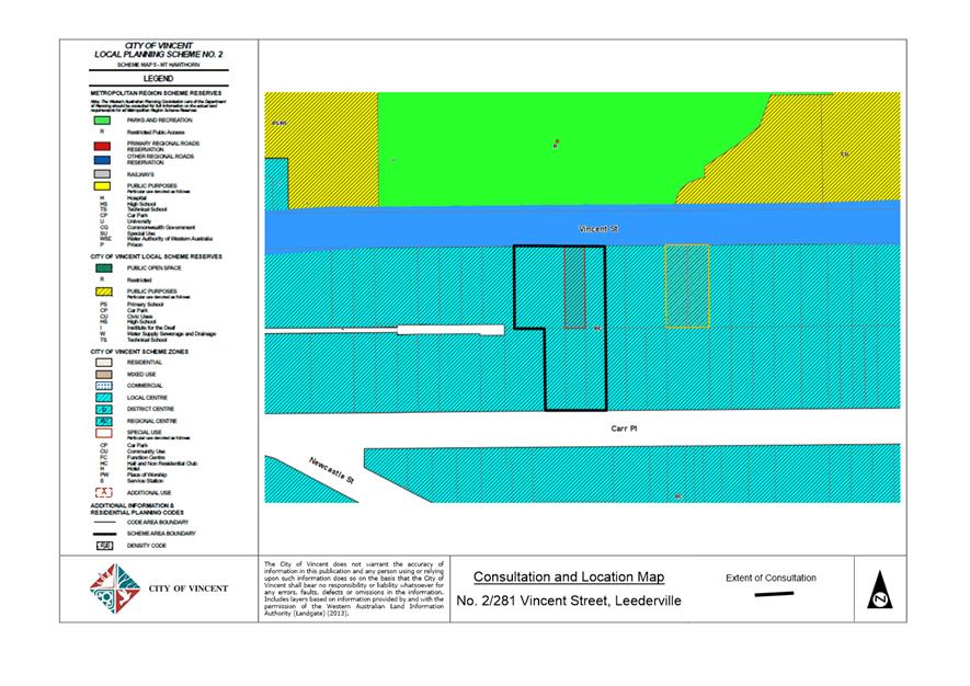
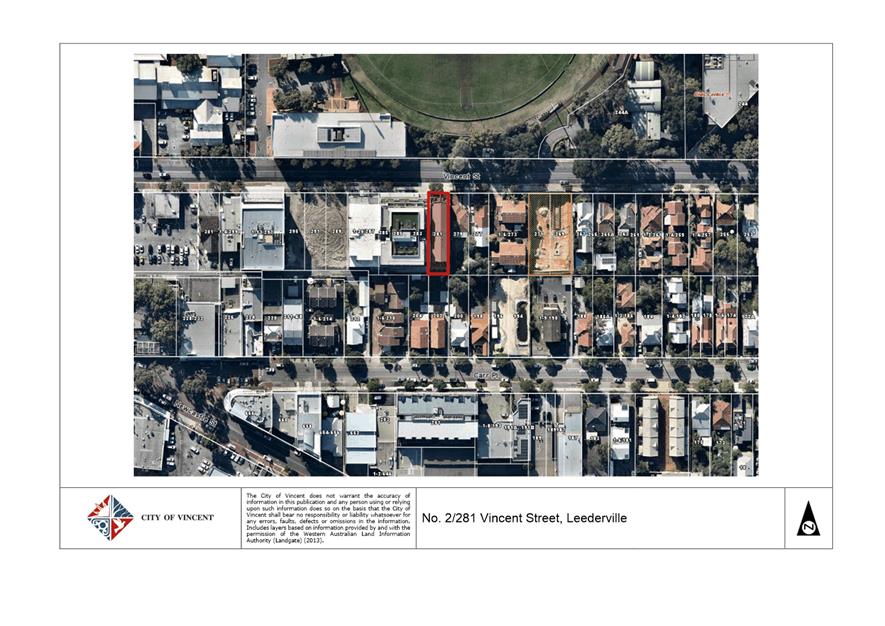
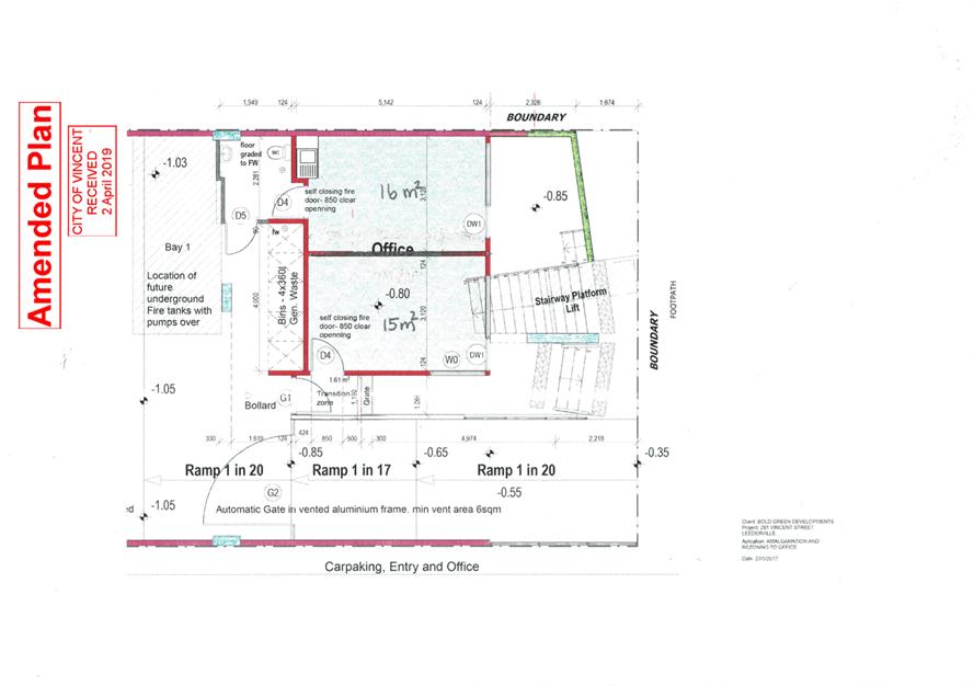
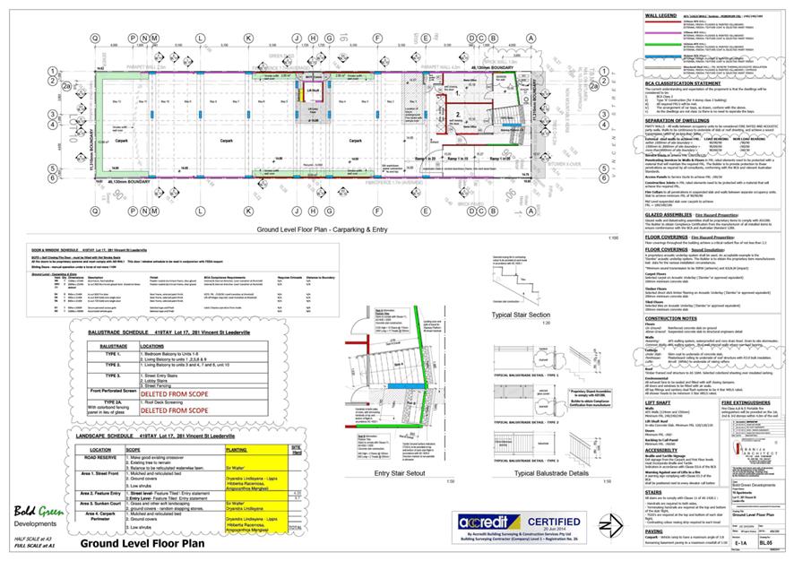
9.3 No. 1/281 (Lot: 1; STR: 73298) and No. 2/281 (Lot: 2; STR: 73298) Vincent Street, Leederville - Proposed Change of Use from Home Office to Office
TRIM Ref: D19/57719
Author: Clair Morrison, Urban Planner
Authoriser: John Corbellini, Executive Director Development Services
Ward: South
Attachments: 1. Attachment
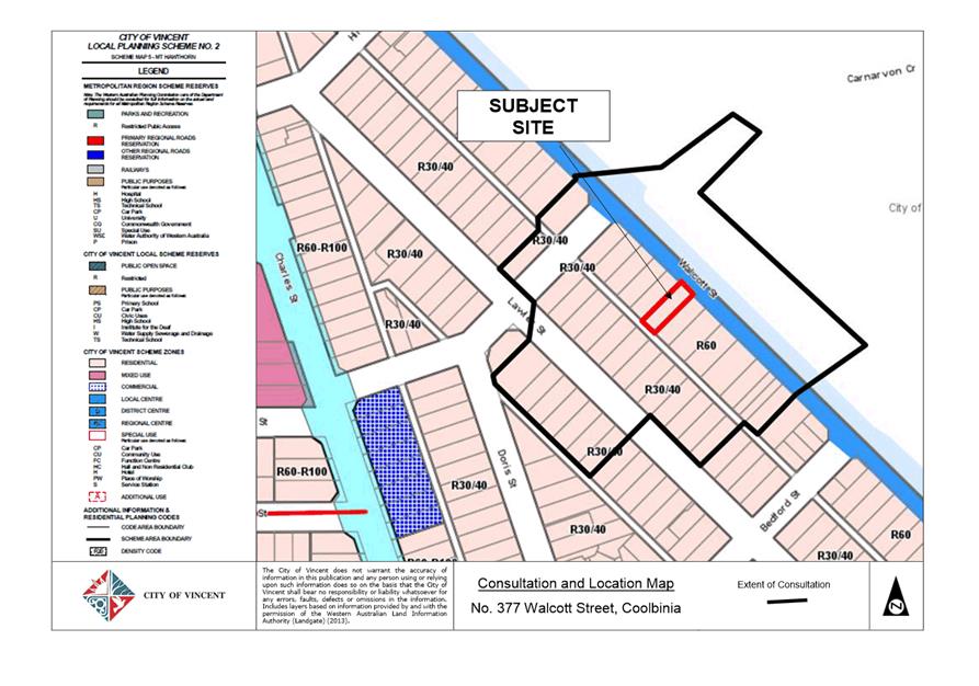
1 - Consultation and Location Map ⇩ ![]()
2. Attachment 2 -
Development Plans ⇩ ![]()
3. Attachment 3 -
Summary of Submissions and Administrations Response ⇩ ![]()
4. Attachment 4 -
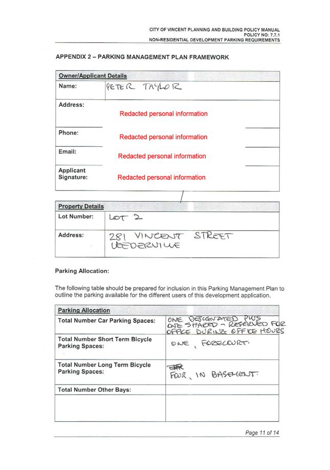
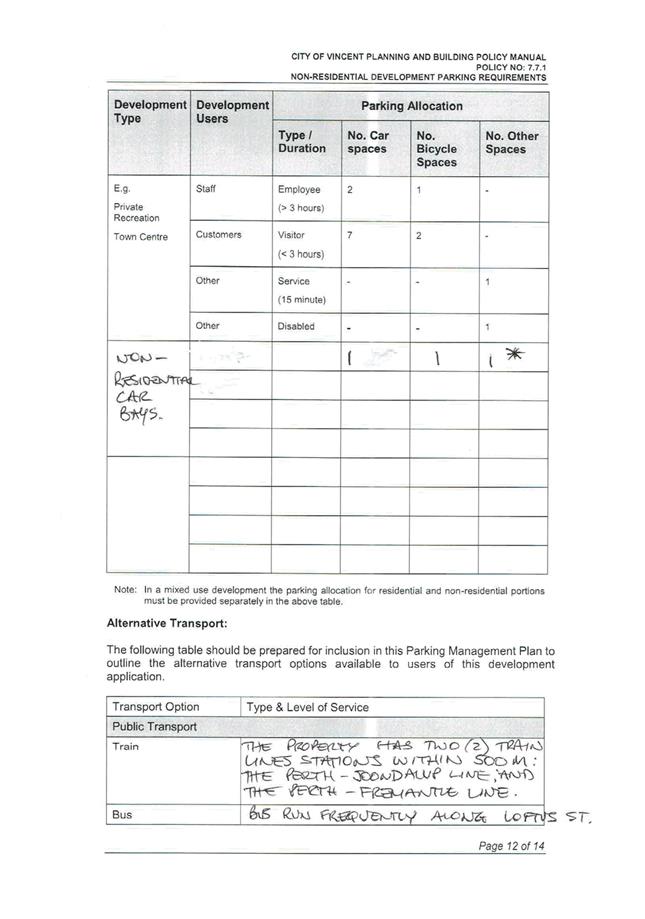
Parking Management Plan ⇩ ![]()
5. Attachment 5 -
Minutes of the Ordinary Meeting of Council held on 18 December 2012 (Previous
Council Decision) ⇩ ![]()
6. Attachment 6 -
Determination Advice Notes ⇩ ![]()
|
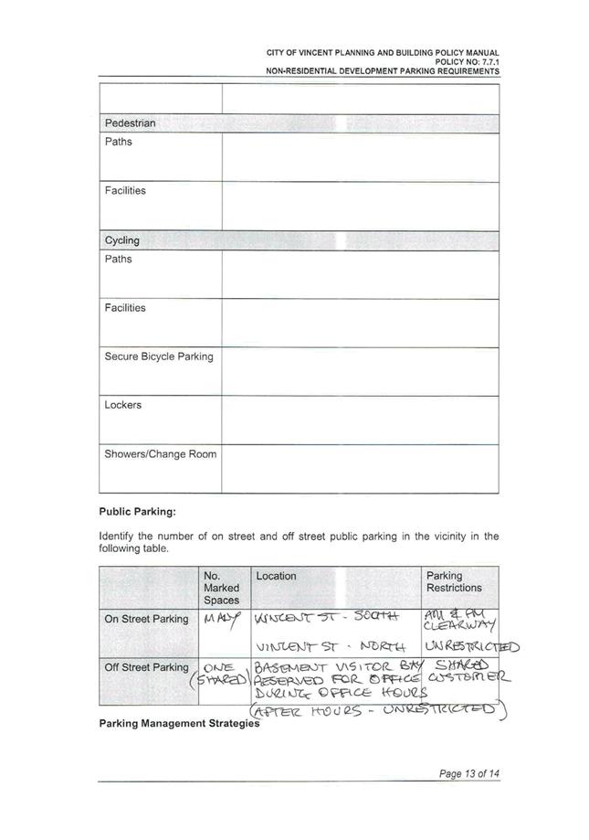
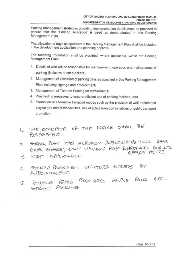
That Council, in accordance with the provisions of the City of Vincent Local Planning Scheme No. 2 and the Metropolitan Region Scheme, APPROVES the application for development approval for a Change of Use from Home Office to Office at No. 1 (Lot: 1; STR: 73298) and No. 2/281 (Lot: 2; STR: 73298) Vincent Street, Leederville in accordance with the plans shown in Attachment 2, subject to the following conditions, with the associated determination advice notes in Attachment 6: 1. Use of Premises 1.1 This approval is for a change of use to ‘Office’ as shown on the plans dated 6 March 2019. It does not relate to any other development on the site; 1.2 The area shown as ‘Office’ on the approved plans shall be used in accordance with the definition of ‘Office’ as defined by the City’s Local Planning Scheme No. 2; 1.3 A maximum of four staff are permitted to be on-site at any given time; and 1.4 The Office shall not operate outside of the following times without further approval from the City of Vincent: · 8:00am – 6:00pm Monday – Friday; · 8:00am – 1:00pm Saturday; · CLOSED Sunday and Public Holidays; 2. Interactive Frontage The development shall maintain an active and interactive relationship and uninterrupted views between the use of the development and Vincent Street during the hours of the development’s operation to the satisfaction of the City. Darkened, obscured, mirror or tinted glass or the like is prohibited. Curtains, blinds and other internal or external treatments that obscure the view of the internal area from Vincent Street are not permitted to be used during the hours of the developments operation; 3. Parking Management Plan The Parking Management Plan approved as part of this application shall be implemented to the satisfaction of the City prior to the use or occupation of the development;
4. Bicycle Parking A minimum of one class 3 bicycle facility for the Office shall be provided on-site and be designed and installed in accordance with AS2890.3, to the satisfaction of the City, prior to the occupation or use of the development; and 5. Signage Any new signage shall be in strict accordance with the requirements of the City’s Policy No. 7.5.2 – Signs and Advertising, unless further planning approval is granted by the City. |
Purpose of Report:
To consider an application for development approval for a Change of Use from Home Office to Office at No. 1/281 Vincent Street and No. 2/281 Vincent Street, Leederville (the subject site).
PROPOSAL:
The application proposes to change the use of the subject site from Home Office to Office. Details of the proposal include:
· Changing the use of Unit 1 and Unit 2 from Home Office to Office. According to the applicant the existing home offices are currently untenanted and changing the use to Office would allow for leasing to a third party;
· A total of four to six persons would be employed by the business, with three to four persons working on-site at any given time. The hours of operation are recommended to be conditioned to limit the operation of the office land use from between 8:00am and 6:00pm Monday to Friday and 8:00am – 1:00pm Saturday (closed on Sundays and Public Holidays); and
· The application does not propose any internal or external works to the existing building.
The proposed development plans are included as Attachment 2.
Background:
|
Landowner: |
Andrew Young (Unit 1) Peter Taylor (Unit 2) |
|
Applicant: |
Peter Taylor |
|
Date of Application: |
26 November 2018 |
|
Zoning: |
MRS: Urban LPS2: Zone: Regional Centre R Code: N/A |
|
Built Form Area: |
Town Centre |
|
Existing Land Use: |
Home Office |
|
Proposed Use Class: |
Office ‘D’ |
|
Lot Area: |
521m2 |
|
Right of Way (ROW): |
No |
|
Heritage List: |
No |
At the Ordinary Council Meeting on 18 December 2012, Council approved a development application for a four storey building on the subject site, consisting of ten multiple dwellings and two home offices.
The subject site is bounded by Vincent Street to the north, a single storey single house to the east at No. 279 Vincent Street, a single storey single house to the south at No. 200 Carr Place and a six storey multiple dwelling development to the west at No. 285 Vincent Street.
The subject site is zoned Regional Centre under Local Planning Scheme No. 2 (LPS2) and the subject site and adjoining properties are within the Town Centre built form area under the City’s Policy No. 7.1.1 – Built Form.
The subject site is affected by Clause 32(1) of LPS2, which states that an Office land use is not permitted on the ground floor or at grade level with the street within the Regional Centre zone unless the application has been assessed and advertised to adjoining residents in accordance with Clause 34 of LPS2.
Details:
Summary Assessment
The table below summarises the planning assessment of the proposal against the provisions of the City of Vincent LPS2 and the City’s Policy No. 7.7.1 – Non-Residential Development Parking Requirements (Parking Policy). In each instance where the proposal requires the discretion of Council, the relevant planning element is discussed in the Detailed Assessment section following from this table.
|
Planning Element |
Use Permissibility/ Deemed-to-Comply |
Requires the Discretion of Council |
|
Land Use |
|
ü |
|
Car Parking |
|
ü |
|
Bicycle Facilities |
ü |
|
Detailed Assessment
The deemed-to-comply assessment of the elements that require the discretion of Council are as follows:
|
Land Use |
|
|
Deemed-to-Comply Standard |
Proposal |
|
Local Planning Scheme No. 2
Clause 32(1) of LPS2 states that an Office land use is not permitted on the ground floor or at grade level with the street within the Regional Centre zone. |
The application proposes two Office land uses on the ground floor within the Regional Centre zone. |
|
Car Parking |
|
|
Deemed-to-Comply Standard |
Proposal |
|
Policy No. 7.7.1
Office: 1.5 bays per 100sqm NLA
1.5 x 0.31 = 0.465 bays
1 car parking bay |
Nil |
The above elements of the proposal do not meet the specified deemed-to-comply standards and are discussed in the comments section below.
Consultation/Advertising:
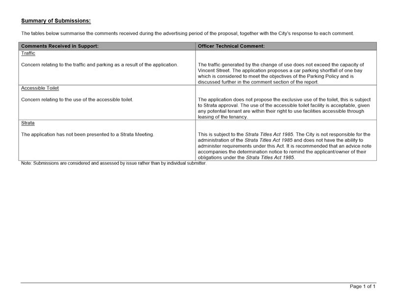
Community consultation was undertaken in accordance with the Planning and Development (Local Planning Schemes) Regulations 2015, for a period of 21 days commencing on 9 January 2019 and concluding on 30 January 2019. Community consultation was undertaken by means of a sign on site, a newspaper advert and 69 letters being sent to surrounding owners and occupiers, as shown in Attachment 1. The City received four submissions, all objecting to the proposal. A summary of the submissions received and Administration’s response is provided in Attachment 3.
The objections received predominately raised concerns in relation to the requirement for strata approval under the Strata Titles Act 1985. The City is not responsible for the administration of this Act and an advice note is recommended to be included on the determination notice to remind the applicant/owner of their obligations under this Act.
Design Review Panel (DRP):
Referred to DRP: No
Legal/Policy:
· Planning and Development Act 2005;
· Planning and Development (Local Planning Schemes) Regulations 2015;
· City of Vincent Local Planning Scheme No. 2;
· Policy No. 4.1.5 – Community Consultation; and
· Policy No. 7.7.1 – Non-Residential Development Parking Requirements.
Should Council refuse the application for development approval, the applicant will have the right to have the decision reviewed in accordance with Part 14 of the Planning and Development Act 2005.
Delegation to Determine Applications:
This matter is being referred to Council for determination as the Applicant has requested that the requirement to pay cash-in-lieu in accordance with the Parking Policy be waived.
Risk Management Implications:
There are minimal risks to Council and the City’s business function when Council exercises its discretionary power to determine a planning application.
Strategic Implications:
This is in keeping with the City’s Strategic Community Plan 2018-2028:
Innovative and Accountable
We are open and accountable to an engaged community.
SUSTAINABILITY IMPLICATIONS:
Nil.
Financial/Budget Implications:
Should the Council waive the cash-in-lieu requirement, the City would not receive the $2,511 payment that is required under the Parking Policy.
Comments:
Land Use
Clause 32(1) of LPS2 states that an Office land use is not permitted on the ground floor or at grade level with the street within the Regional Centre zone. Notwithstanding this, an Office use is capable of being approved in accordance with Clause 34(2) of LPS2 provided that the City is satisfied that the proposal satisfies the following criteria of Clause 34(5):
(a) approval of the proposed development would be appropriate having regard to the matters that the local government is to have regard to in considering an application for development approval as set out in clause 67 of the deemed provisions; and
(b) the non-compliance with the additional site and development requirement will not have a significant adverse effect on the occupiers or users of the development, the inhabitants of the locality or the likely future development of the locality.
With regard to a) above, the proposed Office use is appropriate having regard to the matters to be considered by local government set out in Clause 67 of the Planning and Development (Local Planning Schemes) Regulations 2015 deemed provisions for the following reasons:
· The office land use is consistent with the objectives of the Regional Centre zone under LPS2, specifically:
o Increasing the range of services and uses to cater for the local community; and
o Broadening the range of employment opportunities within the area;
· The existing courtyards between the proposed office tenancy and the street provide adequate opportunity for interaction between the development and the public realm as well as passive street surveillance. A condition is recommended to ensure that an interactive frontage is maintained;
· The proposal provides increased employment opportunities within the Leederville Town Centre, noting that the subject site is currently vacant. This reflects the intent of the planning framework for the locality including the Leederville Masterplan;
· Vincent Street is characterised by single, grouped and multiple dwellings, retail, café and office land uses. The western adjoining lots include multiple dwellings with commercial and office land uses at ground level. The eastern adjoining lots include single dwellings. The northern adjoining lots include public office buildings. Given this, the application is in line with and reflective of the existing character and land uses of the locality;
· The proposal meets the objectives of the City’s Parking Policy and is unlikely to generate traffic that exceeds the capacity of the existing road system in the locality, as discussed in further detail below.
With regard to b) above, the consultation process undertaken in relation to the proposal has identified that the office land use would not significantly adversely impact on the occupiers or users of the development, the inhabitants of the locality or the likely future development of the locality.
It is unlikely that the proposed low scale office with a total NLA of 31 square metres for the two proposed Offices would result in a land use with a greater intensity or amenity impact than that of other land uses that are permitted within the Regional Centre zone under LPS2 including shop, restaurant/café, liquor store – small, lunch bar and convenience store.
As outlined in the Consultation/Advertising section of this report, the four objections received during the consultation period raised concerns in relation to the requirement for strata approval under the Strata Titles Act 1985 as opposed to concerns relating to planning matters. A summary of the submissions received and the Administration’s response is provided in Attachment 3.
Car Parking
In accordance with the City’s Parking Policy, an office at the subject site is required to provide 1.5 spaces per 100 square metres of net leasable area (NLA) on-site. The proposal requires one (rounded up from 0.465) parking space based on 31 square metres of NLA.
The existing development on site provides compliant resident parking and a one bay visitor parking shortfall in accordance with the approval granted by Council at its meeting on 18 December 2012. Whilst there are twelve parking spaces within the existing development to service the ten multiple dwellings, there are no parking spaces allocated to the two home offices. This results in a car parking shortfall of one space when considering the current proposal.
In considering the proposed car parking shortfall, the following is relevant:
· The proposed office with a net leasable area of 31 square metres is relatively small in comparison to other office space located along Vincent Street and is likely to have minimal visitors and associated vehicle movements during operating hours in comparison to other uses, such as medical centre, consulting rooms, café or retail land uses;
· The development is proposed to be conditioned for a maximum of four staff at any one time;
· The proposal is located within a well-serviced area, in relation to access, public transport and sustainable modes of transport;
o The subject site is located approximately 580 metres from the Leederville Train Station by constructed footpaths;
o The subject site is located approximately 200 metres from an existing high frequency bus route, as defined in the Residential Design Codes, running along Oxford Street;
· Ticketed on-street car parking is available directly adjacent to the subject site along Vincent Street. These on-street car bays are subject to a clearway parking restrictions from 7:30am to 9:00am and 4:15pm to 6:00pm Monday to Friday but are otherwise unrestricted. These bays are generally used by residents and visitors to the businesses and dwellings along this section of Vincent Street;
· The existing development on site provides compliant bicycle parking in accordance with the approval granted by Council at its meeting on 18 December 2012. Whilst the proposal does not require any additional bicycle parking facilities to be provided on site in accordance with the City’s Parking Policy, the applicant has agreed to provide one class 3 bicycle facility on-site. A condition of approval is recommended to ensure that this facility is provided accordingly; and
· The car parking provided satisfies the objectives of the City’s Parking Policy and is acceptable to service the development without the provision of a cash-in-lieu contribution.
TRIM Ref: D19/40444
Author: Stephanie Norgaard, Urban Planner
Authoriser: John Corbellini, Executive Director Development Services
Ward: North
Attachments: 1. Attachment
1 - Location and Consultation Plan ⇩ ![]()
2. Attachment 2 -
Development Plans 5 March OCM ⇩ ![]()
3. Attachment 3 -
Revised Development Plans ⇩ ![]()
4. Attachment 4 -
Administration's Response to Summary of Submissions ⇩ ![]()
5. Attachment 5 -
Applicant's Response to Summary of Submissions ⇩ ![]()
6. Attachment 6 -
Applicant's Response to Design Review Minutes ⇩ ![]()
7. Attachment 7 -
Determination Advice Notes ⇩ ![]()
|
That Council in accordance with Section 31 of the State Administrative Tribunal Act 2004, the provisions of the City of Vincent Local Planning Scheme No. 2 and the Metropolitan Region Scheme, SETS ASIDE its deemed refusal and APPROVES the application for development approval for four Multiple Dwellings at No. 377 (Lot: 162; D/P: 2630) Walcott Street, Coolbinia in accordance with the plans shown in Attachment 3, subject to the following conditions, with the associated determination advice notes in Attachment 7: 1. Development Plans The screening provided to the balcony of Unit 1 and Unit 3 shall restrict views into the adjoining property within the 7.5 metre cone of vision in accordance with State Planning Policy 3.1: Residential Design Codes. Screening shall be a minimum height of 1.6 metres from the finished floor level, permanently affixed and a minimum of 75 percent obscure; 2. Landscaping 2.1 A detailed landscape and reticulation plan for the development site and adjoining road verge to the City’s satisfaction shall be lodged with and approved by the City prior to commencement of the development. The plan shall be drawn to a scale of 1:100 and show the following: · The location and type of existing and proposed trees and plants; · Areas to be irrigated or reticulated; · A total of 16 percent of the site area as deep soil zone; and · The location of canopy cover at maturity equating to no less than 30 percent of the site and no less than two medium trees; 2.2 All works shown in the plans as identified in Condition 2.1 above shall be undertaken in accordance with the approved plans to the City’s satisfaction, prior to occupation or use of the development and shall be maintained thereafter to the satisfaction of the City at the expense of the owners/occupiers; 3. Boundary Walls The owners of the subject land shall finish and maintain the surface of the boundary walls in a good and clean condition prior to the occupation or use of the development and thereafter to the satisfaction of the City;
4. Schedule of External Finishes Prior to the commencement of development a detailed schedule of external finishes (including materials and colour schemes and details) shall be submitted to and approved by the City. The development shall be finished in accordance with the approved schedule prior to the use or occupation of the development; 5. Stormwater All stormwater produced on the subject land shall be retained on site, by suitable means to the full satisfaction of the City; 6. Clothes Drying Facility All external clothes drying areas shall be adequately screened in accordance with State Planning Policy 3.1: Residential Design Codes prior to the use or occupation of the development and shall be completed to the satisfaction of the City; 7. External Fixtures All external fixtures and building plant, including air conditioning units, piping, ducting and water tanks, shall be located so as to minimise any visual and noise impact on surrounding landowners, and shall be screened from view from the street, and surrounding properties to the satisfaction of the City; 8. Waste Management Plan 8.1 A waste management plan to the satisfaction of the City shall be submitted to, and approved by the City prior to the commencement of development; 8.2 The bin storage area shall be provided as set out in the approved waste management plan; and 8.3 Waste Management for the development shall be undertaken in accordance with the approved waste management plan for the duration of the development; 9. Car Parking and Vehicle Access The car parking and access areas (including ramp grading) shall comply with the requirements of AS2890.1; 10. Bicycle Parking A minimum of two bicycle bays are to be provided and installed to the satisfaction of the City in accordance with AS2890.3; 11. Construction Management Plan A Construction Management Plan that details how the construction of the development will be managed to minimise the impact on the surrounding area, to the satisfaction of the City, shall be lodged with and approved by the City prior to the commencement of the development. The Construction Management Plan shall be prepared in accordance with the requirements of the City’s Policy No. 7.5.23 – Construction Management Plans and include traffic and parking management requirements during construction. Construction on and management of the site shall thereafter comply with the approved Construction Management Plan; 12. Right of Way Widening A 0.5 metre section of land shall be provided for right-of-way widening at the time of subdivision, in accordance with the approved development plan. The land required for right of way widening shall be transferred from the land owner to the Crown free of cost for the purpose of widening; and 13. Road Widening (Walcott Street) 13.1 The landowner agrees to remove any landscaping, development or other works at the time when the reserved land is required for the upgrading of Walcott Street at their own expense, if required; and 13.2 The landowner agrees that any improvements made to or loss of amenity will not be taken into consideration in determining any land acquisition cost or compensation which may be payable by Council or the Western Australian Planning Commission at such time as the land is required. |
Purpose of Report:
To consider an application for development approval for four Multiple Dwellings at No. 377 Walcott Street, Coolbinia (subject site).
PROPOSAL:
The application proposes the development of four two-bedroom Multiple Dwellings on the subject site. The proposed Multiple Dwellings have a three-storey building height above the existing natural ground level. The application proposes excavation for a portion of the site to facilitate undercroft car parking.
Background:
|
Landowner: |
Building Development Group Pty Ltd |
|
Applicant: |
Building Development Group Pty Ltd |
|
Date of Application: |
7 November 2018 |
|
Zoning: |
MRS: Urban/Other Regional Roads LPS2: Zone: Residential R Code: R60 |
|
Built Form Area: |
Transit Corridor |
|
Existing Land Use: |
Single House |
|
Proposed Use Class: |
Multiple Dwelling |
|
Lot Area: |
455 square metres |
|
Right of Way (ROW): |
Yes, 5.0 metres wide, drained and sealed |
|
Heritage List: |
No |
The subject site is located at No. 377 Walcott Street, Coolbinia, as shown on the location plan included as Attachment 1. There is an existing Single House on the subject site.
The subject site has frontages to Walcott Street to the north-east and a right of way (ROW) to the south-west. The site is adjoining a Single House to the south-east and a Single House to the north-west. The property to the north-west has a current development approval for the construction of a two-storey Grouped Dwelling. The broader area is generally characterised by single storey Single Dwellings.
The subject site is zoned Residential with a density coding of R60 under the City’s Local Planning Scheme No. 2 (LPS2). The subject site and adjoining properties along Walcott Street are within the Transit Corridor built form area under the City’s Policy No. 7.1.1 – Built Form (Built Form Policy). Walcott Street is reserved as an Other Regional Road (ORR) under the Metropolitan Region Scheme (MRS). The subject site is affected by 1.5 metres of road widening to Walcott Street as per the Department of Planning, Lands and Heritage (DPLH) Land Requirement Plan. The subject site is also subject to the City’s requirement for 0.5 metres of ROW widening.
The development application was presented to Council at its Ordinary Council meeting on 5 March 2019. The development plans from the March 5 2019 Ordinary Council meeting are included as Attachment 2. The application was deferred by Council to enable the applicant time to address following matters:
· Parking configuration;
· Visitor car parking arrangements;
· Articulation of the south east façade;
· Landscaping; and
· Storage solutions in addition to the lift return on the roof.
Administration received notification that the applicant had lodged an appeal with the State Administrative Tribunal on 6 March 2019. Administration, with the consent of the applicant, requested the Directions Hearing be postponed to the 10 May 2019 to allow the applicant time to submit amended plans for Council’s consideration. The SAT issued Orders requiring the applicant to lodge revised plans with the City and invited Council to consider these revised plans pursuant to section 31(1) of the State Administrative Tribunal Act 2004 (WA) on or before 30 April 2019.
The applicant has submitted revised plans for reconsideration. The main changes between the deferred plans and the revised plans are summarised as follows:
· Removal of sections of feature render on the south-east elevation and introduction of face brick cladding and feature vertical cladding;
· Introduction of a central break within the roof line on the south-east façade;
· Removal of the London Plane tree species and instruction of Chinese Elm and Bradford Pear tree species;
· Reduction in tree canopy cover from 27 percent to 19.94 percent;
· Increase setback of Unit 3 from the south east boundary from 1.8 metres to 1.9 metres (living) and 1.2 metres to 1.3 metres (kitchen);
· Introduction of additional section of excavation to accommodate the lift pit;
· Orientation of skillion roof flipped;
· Reduction of overall building height by 0.1 metres;
· Introduction of two additional visitor bays so that each unit has one visitor bay each; and
· Introduction of screen gates across the resident car bays.
A copy of the revised development plans is included as Attachment 3.
Details:
Summary Assessment
The table below summarises the planning assessment of the proposal against the provisions of LPS2, the Built Form Policy and the State Government’s Residential Design Codes (R Codes). In each instance where the proposal requires the discretion of Council, the relevant planning element is discussed in the Detailed Assessment section following from this table:
|
Planning Element |
Use Permissibility/ Deemed-to-Comply |
Requires the Discretion of Council |
|
Plot Ratio |
|
ü |
|
Street Setback |
ü |
|
|
Front Fence |
ü |
|
|
Building Setbacks/Boundary Wall |
|
ü |
|
Building Height |
ü |
|
|
Open Space |
ü |
|
|
Outdoor Living Areas |
ü |
|
|
Landscaping (R Codes) |
ü |
|
|
Privacy |
ü |
|
|
Parking & Access |
ü |
|
|
Sight Lines |
|
ü |
|
Bicycle Facilities |
ü |
|
|
Solar Access |
ü |
|
|
Site Works/Retaining Walls |
ü |
|
|
Essential Facilities |
ü |
|
|
External Fixtures |
ü |
|
|
Surveillance |
ü |
|
Detailed Assessment
The deemed-to-comply assessment of the elements that require the discretion of Council is as follows:
|
Plot Ratio |
|
|
Deemed-to-Comply Standard |
Proposal |
|
R Codes Clause 6.1.1
Plot Ratio: 0.70 (318.5 square metres) |
Plot Ratio: 0.76 (344.4 square metres) |
|
Lot Boundary Setbacks |
|
|
Deemed-to-Comply Standard |
Proposal |
|
R Codes Clause 6.1.4
North-West
Unit 1: 1.5 metres Unit 2: 1.5 metres Unit 3: 1.7 metres Unit 4: 1.8 metres
|
North-West
Unit 1: 1.2 metres (kitchen) Unit 2: 1.2 metres (kitchen) Unit 3: 1.2 metres (kitchen) Unit 4: 1.2 metres (kitchen) |
|
South-East
Unit 1 and Unit 2 (bedroom 1, stairwell, bedroom 1): 2.4 metres Unit 3 (bathroom, bedroom 2): 1.4 metres Unit 4 (bathroom, bedroom 2): 1.3 metres Unit 3 and Unit 4 (bedroom 1, stairwell, bedroom 1): 3.8 metres |
South-East
Unit 1 and Unit 2 (bedroom 1, stairwell, bedroom 1): 1.8 metres Unit 3 (bathrooms, robe): 1.3 metres Unit 3 and Unit 4 (bedroom 1, stairwell, bedroom 1): 1.9 metres |
|
Sight Lines |
|
|
Deemed-to-Comply Standard |
Proposal |
|
R Codes Clause 6.2.3
Walls, fences and other structures truncated or reduced to a height of 0.75 metres within the 1.5 metres visual truncation area. |
Existing boundary fencing located within visual truncation area. |
The above elements of the proposal do not meet the specified deemed-to-comply standards and are discussed in the Comments section below.
Consultation/Advertising:
Community consultation was undertaken in accordance with the Planning and Development (Local Planning Scheme) Regulations 2015, for a period of 41 days commencing on 4 December 2018 and concluding on 15 January 2019. The community consultation period was extended to account for the holiday period affecting December and January. The method of consultation included 64 letters being sent to surrounding landowners within a 100 metre radius of the subject property, as shown in Attachment 1.
During the community consultation period, the City received one submission in support of the proposal, seven submissions in objection to the proposal and four submissions neither objecting nor supporting to the proposal. The submission received in support of the proposal did not provide specific comments or reasons for the support. The submissions received objecting to the proposal raised the following key concerns:
· Non-compliance with the deemed-to-comply standards of the R Codes;
· Visual impact of the proposal on the nearby properties in terms of bulk and scale;
· Inconsistency of the proposal with the existing single house residential character of the area;
· Impact of the proposal on the usability of the ROW in terms of increased traffic, noise and safety; and
· Impact of the proposal on the adjoining properties in terms of overshadowing and visual privacy.
Following community consultation, the applicant provided revised plans that included an elevator within the development and other minor amendments to the building facades. The revised plans were re-advertised between 4 February and 11 February 2019. The method of community consultation was in the form of written notification to the submitters of the proposal. Following the conclusion of community consultation, the City received two submissions neither objecting nor supporting to the proposal and 15 submissions objecting to the proposal.
The key areas of concern received in objection were the same as those raised in the original submissions.
A summary of the submissions received and Administration’s comment is provided in Attachment 4. The applicant’s response to the summary of submissions is provided in Attachment 5.
Department of Planning Lands and Heritage (DPLH)
The development application was referred to the DPLH for comments due to the site being affected by a 1.5 metre wide ORR reserve along the Walcott Street frontage. DPLH recommended a condition be included on the development approval requiring the landowner to remove the landscaping and associated minor works located within the road widening area at the time Walcott Street is upgraded.
City of Stirling
The development application was referred to the City of Stirling as the subject site is located on the boundary of the City of Vincent and City of Stirling local government areas. The City of Stirling advised that it had no specific comments to provide on the proposal.
Design Review Panel (DRP):
Referred to DRP: Yes
The proposal was referred to the DRP prior to formal lodgement. The applicant provided a response to the comments provided by the DRP, which is included in Attachment 5. Administration also referred the development plans previously considered by Council at its meeting held on 5 March 2019 to the Chair of the DRP. The Chair of the DRP noted the following matters:
· The roof scape and in particular the impact of the storage structure on neighbouring lots. Consider a roof scape that responds to the neighbouring building and a roof scale that encapsulates the storage structure;
· The location of the bin storage being outside of the front setback area; and
· Increasing the sun shading to the north, east and west facing windows.
The development plans subject to this reconsideration have not been presenting to the DRP.
Legal/Policy:
· Planning and Development Act 2005;
· Planning and Development (Local Planning Schemes) Regulations 2015;
· State Administrative Tribunal Act (WA) 2004;
· City of Vincent Local Planning Scheme No. 2;
· State Planning Policy 3.1 – Residential Design Codes;
· Policy No. 4.1.5 – Community Consultation;
· Policy No. 7.1.1 – Built Form Policy; and
· Policy No. 7.5.23 – Construction Management Plans.
In accordance with Schedule 2 Clause 76(2) of the Planning and Development (Local Planning Schemes) Regulations 2015 and Part 14 of the Planning and Development Act 2005, the applicant would have the right to apply to the State Administrative Tribunal for a review of Council’s determination.
City of Vincent Policy No. 7.1.1 – Built Form
The City has undertaken community consultation for amendments to the existing Built Form Policy. The community consultation period concluded on 11 December 2018.
The development has not been assessed against the proposed amendments to the Built Form Policy. The amendments to the Built Form Policy are in draft form and do not reflect the outcome of any changes stemming from the community consultation period and are not reflective of Design WA. The amendments to the Built Form Policy are not considered to be ‘seriously entertained’ as they have not received approval from Council following community consultation and they are not certain or imminent in coming into effect in the form they were advertised in.
The amendments to the Built Form Policy are expected to be presented to Council in the first half of 2019 to consider its acceptability following community consultation.
WAPC’s State Planning Policy 7.3 Residential Design Codes – Volume 2 Apartments
On 18 February 2019, the WAPC released the documentation for Design WA, which includes State Planning Policy 7.3 Residential Design Codes – Volume 2 Apartments and Design Review Guide. The Minister for Planning has announced this would become operational on 24 May 2019. An objective assessment has been completed against the policy.
Delegation to Determine Applications:
This matter is being referred to Council in accordance with the City’s Delegated Authority Register as the proposed development incorporates more than three dwellings and the application received more than five objections during the community consultation period.
Risk Management Implications:
There are minimal risks to Council and the City’s business function when Council exercises its discretionary power to determine a planning application.
Strategic Implications:
This is in keeping with the City’s Strategic Community Plan 2018-2028:
“Innovative and Accountable
We are open and accountable to an engaged community”.
SUSTAINABILITY IMPLICATIONS:
Nil.
Financial/Budget Implications:
Nil.
Comments:
Building Size
The development proposes a plot ratio of 0.76 (344.4 square metres) in lieu of the 0.7 (318.5 square metres) deemed-to-comply standard of the R Codes. The Acceptable Standards of Design WA Clause 2.4 allows a plot ratio of 0.8. In considering the acceptability of the plot ratio, the following is noted:
· The development incorporates design measures to mitigate the impact of building bulk on the streetscape and adjoining properties. This includes the stepping in of the development, setting back the upper level and incorporating varying colours and materials into the building facade;
· The development provides deep soil areas in the front setback and at the rear of the subject site which could accommodate mature tree planting that would provide screening to the development from Walcott Street and the ROW; and
· The bulk and scale of the development is considered to be consistent with the future desired built form outcome of the locality as envisaged by the Transit Corridor built form area of the Built Form Policy. The Transit Corridor built form area permits three-storey building height to facilitate higher density development along major transport routes. The development does not contribute additional bulk due to the design measures discussed above, and is consistent with the intended built form of the area.
The proposal meets the design principles of the R Codes and is supported.
Lot Boundary Setbacks
The development does not meet the deemed-to-comply lot boundary setbacks of the R Codes for sections of the building façade on the north-west and south-east elevations. The Acceptable Standards of Design WA Clause 2.4 Side and rear setbacks require the same side and rear setbacks (3.0 metres). In considering the acceptability of the lot boundary setbacks, the following is noted:
· The development provides articulation in the building façade through stepping in sections of the building which reduces the overall bulk of the development to adjoining properties and as viewed from the street;
· The development has incorporated alternating colours and materials on the facades, which include feature brick, two shades of render, feature cladding and glazing. The inclusion of alternative finishes assists in breaking up the bulk of the building façade to the adjoining properties;
· The sections of wall subject to the reduced lot boundary setbacks do not contain any major openings, meaning the proposed lot boundary setbacks do not result in any departures to the deemed-to-comply standards for visual privacy; and
· The development meets the deemed-to-comply standards of the R Codes with respect to overshadowing. The setbacks provided are sufficient to allow for ventilation between the existing and proposed buildings.
The proposal meets the design principles of the Built Form Policy and the R Codes with regards to lot boundary setbacks and is supported.
Landscaping
The City’s Built Form Policy requires 15 percent of the site to be provided as deep soil zone and 30 percent of the site to be provided as canopy coverage. The Acceptable Outcomes of Design WA Clause 3.3 Tree canopy and deep soil areas requires 10 percent minimum deep soil area and one medium tree and small trees to suit the area. The development provides 16 percent deep soil and 19.94 percent canopy coverage, with one small tree and one medium tree proposed. The landscape plan indicates two alternative tree species to be installed, being either a Chinese Elm or a Bradford Pear. In accordance with Design WA, the Bradford Pear is considered to be a small tree and the Chinese Elm is considered to be a medium tree.
The open air car parking area is required to provide one shade tree, a minimum of 80 percent canopy coverage and a 1.5 metre landscaping strip along the perimeter. The development provides 50 percent canopy coverage, one shade tree and no 1.5 metre landscaping strip.
· The proposed tree species are consistent with the City’s recommended tree species list; and
· The development provides a sufficient deep soil area to achieve 30 percent canopy cover with additional tree planting within the front setback area.
The City recommends a condition be imposed requiring a revised landscape and reticulation plan to be submitted and approved by the City prior to the commencement of development. This revised landscape plan is to demonstrate a minimum of 30 percent canopy coverage and a minimum of two medium sized trees.
Sight Lines
The revised development plans have introduced an additional two visitor bays at the rear of the development. The proposed car parking arrangement does not satisfy the deemed-to-comply standards of the R Codes, which requires a 1.5 metre visual truncation.
The City’s engineering team have reviewed the proposal and deemed that although the dividing fence is not truncated in accordance with the deemed-to-comply standards, the proposed sight lines are considered adequate within the context of the site. Access to the car bays is provided through a ROW, which is a low speed environment with low traffic volumes. The ROW also contains speed bumps to assist with providing traffic calming measures. The proposed sight lines provide safe vehicle access to the proposed car parking bays and are supported.
Design Review Panel Comments
The DRP provided comments in regards to the proposed roof form of the upper level, the location of the bin area within the front setback area and the shading of external windows.
· The storage structure protruding from the roof is setback from the building boundaries to minimise the impact of building bulk as viewed from adjoining properties and the street. The development complies with deemed-to-comply building height and overshadowing standards;
· The proposed bin store complies with the R Codes’ deemed-to-comply standards relating to the design and location of bin store areas. Specifically, the bin store area is provided in a convenient location for residents that is enclosed and bins would be screened from view, and has been designed to integrate with the building design by incorporating materials and colours consistent with the development; and Landscaping is proposed to be installed in front of the bin store area to provide screening.
· The applicant has incorporated window shrouds to serve as a shading device.
The proposal has satisfactorily addressed the DRP’s comments.
Reasons for Deferral
Parking configuration and visitor car parking arrangements
The development plans presented to the 5 March 2019 Ordinary Meeting of Council proposed four basement car bays for residents that were open to the laneway and two visitor parking bays directly behind two of the resident parking bays. The revised development plans provide a tubular steel screening gate to the four resident bays, screening these bays from the ROW. The revised plans also propose four visitor car bays in a tandem car parking arrangement, with one directly behind each of the resident parking bays. This allows each dwelling to have a visitor car bay available for the exclusive use of their visitors.
Articulation of the south east façade
The amended development plans have removed sections of the feature render on the south-east elevation and introduced sections of face brick cladding and feature vertical cladding. A central break has been added to the roof line through removal of a section of the eaves. The modifications to the south-east façade further assists in breaking up the solid nature of the building façade and reducing the perception of building bulk.
Landscaping
The amended landscape plan indicates two alternative tree species from the City’s preferred tree species list. As discussed above, the proposed canopy cover from the alternative tree species does not satisfy the 30 percent canopy cover standard of the City’s Built Form Policy. A condition of approval has been recommended to ensure additional tree plantings is provided to ensure a minimum of 30 percent canopy cover for the site, at maturity.
Storage solutions in addition to the lift return on the roof
The development provides four storage rooms in the basement area. Each storage room has a minimum area of four square metres. In addition to the individual storage rooms, the development provides 12 square metres of common storage in the upper level of the development. The revised development plans have reduced the height of the common storage area on the upper level by 0.1 metres. The angle of the skillion roof on top of the common store has been flipped so the higher side is now on the south-east side of the subject site. Both sides of the skillion roof now have a height of 10 metres from the existing natural ground level and with the slope of the skillion roof now matching the natural slope of the subject site. The exterior finish of the common store has also been changed from light grey render and cladding to a darker grey render and cladding.
The common store satisfies the deemed-to-comply standards of the R Codes and is largely not visible from the adjoining properties, rear ROW or Walcott Street due to its central location above the second storey.
9.5 Nos. 12-16 (Lot: 26; D/P: 13767) Cleaver Street, West Perth - Proposed Amendment to Development Approval: Change of Use from Showroom/Warehouse to Place of Worship
TRIM Ref: D19/45558
Authors: Stephanie Norgaard, Urban Planner
Mitchell Hoad, Senior Urban Planner
Authoriser: John Corbellini, Executive Director Development Services
Ward: South
Attachments: 1. Attachment
1 - Consultation and Location Map ⇩ ![]()
2. Attachment 2 -
Minutes of 25 February 2014 Council Meeting ⇩ ![]()
3. Attachment 3 -
Statement of Use ⇩ ![]()
4. Attachment 4 -
Acoustic Report ⇩ ![]()
|
That Council in accordance with the provisions of the City of Vincent Local Planning Scheme No. 2 and the Metropolitan Region Scheme, APPROVES the application to amend planning approval for a Change of Use from Showroom/Office to Place of Worship at Nos. 12-16 Cleaver Street (Lot: 26; D/P: 13767) Cleaver Street, West Perth, granted on 25 February 2014, subject to the following conditions: 1. All conditions, requirements and advice notes detailed on development approval 5.2013.439.1 granted on 25 February 2014 continue to apply to this approval, with the exception of Condition 1.1 which is deleted. |
Purpose of Report:
To consider an application for development approval to amend Condition 1.1 of the development approval issued by Council at its Ordinary Council Meeting held on 25 February 2014. Condition 1.1 of the development approval restricts the approval period to a period of five years, which expired on 25 February 2019 (see Attachment 2).
PROPOSAL:
Council at its Ordinary Council Meeting held on 25 February 2014 granted conditional approval for a change of use on the subject site from Showroom/Warehouse to Place of Worship (previously Sonlife Church). Condition 1.1 of the development approval limited the approval period to five years. Sonlife Church ceased operations at the subject site in October 2018. The applicant, Heart of the City Church started operations from the subject site in December 2018. The application proposes to remove Condition 1.1 of the development approval to allow the Place of Worship (now Heart of the City Church) to operate in perpetuity. A summary of the operating hours of the Place of Public Worship and expected number of attendees is as follows:
Office Operations
· 8:30am – 5:00pm Tuesday – Friday
· Maximum three persons
Church Services
· 10:00am – 11:15am Sundays
· Maximum 80 persons
Music Practice
· 7:00pm – 8:30pm Wednesdays
· Maximum 15 persons
The application does not propose any physical changes to the external appearance of the existing building. The statement of use is included as Attachment 3. The proposed hours of operation and maximum occupancy remains consistent with the conditions of approval issued by Council on 25 February 2014. The operations of Heart of the City Church remain generally consistent with the operations of the previously approved Sonlife Life Church, with the exception of the music practice, which is a new service offered by Heart of the City Church, but which can operate in accordance with the conditions of the previous approval.
Condition 1.1 of the Council minutes identifies that there is an error in the wording of Condition 1.1 which states that the approval is valid for five years, until 25 February 2017, however the approval was issued on 25 February 2014. The application proposes the removal of this condition, which is discussed in further detail in the Comment section of this report.
Background:
|
Landowner: |
Anita Percudani and Loretta Ricciardi |
|
Applicant: |
Heart of the City Church |
|
Date of Application: |
11 February 2019 |
|
Zoning: |
MRS: Industrial LPS2: Zone: Commercial |
|
Built Form Area: |
Mixed Use |
|
Existing Land Use: |
Place of Worship |
|
Proposed Use Class: |
Place of Worship |
|
Lot Area: |
1,682m² (tenancy 395m²) |
|
Right of Way (ROW): |
No |
|
Heritage List: |
No |
The subject site is legally described as Nos. 12 – 16 Cleaver Street, West Perth, which comprises of four separate lots (being Lots 26, 27, 102, 103) with a combined area of 4,454 square metres. This application relates to Lot 26 only, which contains four separate premises. Of the four premises located on Lot 26, this application relates to the premises commonly known as No. 8 Cleaver Street, West Perth (the subject tenancy).
The subject tenancy is an existing Place of Worship which is built boundary to boundary, as shown on the location map included as Attachment 1. The site has a single frontage to Cleaver Street to the west and is bound to the north, south and east by warehouses. The broader locality is characterised by a mix of uses including offices/warehouses, vehicle sales and repair premises, recreation centre and a reception centre/exhibition centre.
The subject site and the surrounding area is zoned Commercial under the City’s Local Planning Scheme No. 2 (LPS2) and located within the Mixed Use built form area under the City’s Policy No. 7.1.1 – Built Form.
Details:
Summary Assessment
The table below summarises the planning assessment of the proposal against the provisions of LPS2. In each instance where the proposal requires the discretion of Council, the relevant planning element is discussed in the Detailed Assessment section following from this table.
|
Planning Element |
Use Permissibility/ Deemed-to-Comply |
Requires the Discretion of Council |
|
Land Use |
|
P |
Detailed Assessment
The deemed-to-comply assessment of the element that requires the discretion of Council is as follows:
|
Land Use |
|
|
Deemed-to-Comply Standard |
Proposal |
|
Local Planning Scheme No. 2
“P” permitted use |
“D” discretionary use |
The above element of the proposal does not meet the specified deemed-to-comply standards and is discussed in the comments section below.
Consultation/Advertising:
Community consultation was undertaken in accordance with the Planning and Development (Local Planning Scheme) Regulations 2015, for a period of 14 days commencing on 18 March 2019 and concluding on 1 April 2019. Community consultation was undertaken by means of written notification being sent to all surrounding landowners, as shown in Attachment 1 and a notice on the City’s website. No submissions were received at the conclusion of community consultation.
Design Review Panel (DRP):
Referred to DRP: No
Legal/Policy:
· Planning and Development Act 2005;
· Planning and Development (Local Planning Schemes) Regulations 2015;
· City of Vincent Local Planning Scheme No. 2;
· Perth Parking Management Act 1999;
· Perth Parking Policy 2014; and
· Policy No. 4.1.5 – Community Consultation.
In accordance with Schedule 2 Clause 76(2) of the Planning and Development (Local Planning Schemes) Regulations 2015 and Part 14 of the Planning and Development Act 2005, the applicant will have the right to apply to the State Administrative Tribunal for a review of Council’s determination.
Delegation to Determine Applications:
The development application is being referred to Council as the proposal relates to a matter previously determined by Council.
Risk Management Implications:
There are minimal risks to Council and the City’s business function when Council exercises its discretionary power to determine a planning application.
Strategic Implications:
This is in keeping with the City’s Strategic Community Plan 2018-2028:
Innovative and Accountable
We are open and accountable to an engaged community.
SUSTAINABILITY IMPLICATIONS:
Nil.
Financial/Budget Implications:
Nil.
Comments:
Land Use
The subject site and surrounding area is zoned Commercial under the City’s LPS2. The proposed Place of Worship is a ‘D’ use within the Commercial zone, meaning the use is not permitted unless Council exercises its discretion.
The original development approval for the subject site was issued under the Town Planning Scheme No. 1 (TPS1). Under TPS1, the subject site was also zoned Commercial and the land use permissibility for a Place of Worship was ‘AA’, which is equivalent to a ‘D’ use under LPS2.
The Place of Worship is consistent with the objectives of the Commercial zone under LPS2 and is supported for the following reasons:
· The development re-uses an existing building on-site with minor modifications and upgrades proposed to the interior of the building. The adaptive re-use of an existing building is considered to be consistent with sustainability principles;
· The application proposes no alterations to the existing façade of the building, ensuring that the development would maintain the existing streetscape character and amenity of Cleaver Street;
· The subject site is located approximate 80 metres south of the closest residential dwellings, which are located on the northern side of Newcastle Street. The separation distance between the subject site and the nearby residential properties is considered sufficient to mitigate the occurrence of any conflicts between the commercial and residential land uses. The Acoustic Report provided by the applicant confirms the operations of the Place of Worship complies with the requirements of the Environmental Noise Regulations 1997;
· The Place of Worship is compatible with existing commercial uses along Cleaver Street, which includes a Reception Centre/Exhibition Centre, Warehouses and Recreational Facility; and
· Since approval in 2014, the City has no records of receiving any complaints relating to the operations of the Place of Worship.
Perth Parking Management Act 1999
The subject lot is located within the area subject to the Perth Parking Management Act 1999, which establishes the Perth Parking Management Plan Area and the Perth Parking Policy 2014. The Perth Parking Policy 2014 introduces maximum parking limits to all land located within the Perth Parking Management Plan Area. The City’s Policy No. 7.7.1 – Non-Residential Development Parking Requirements does not apply to land located within the Perth Parking Management Plan Area.
The subject lot is located within a ‘Category 4’ area under the Perth Parking Policy 2014, which requires a maximum of 200 car bays per 10,000 square metres of lot area. The subject lot is permitted to provide a maximum of 34 car bays for the four tenancies. The subject lot contains nil on-site car bays, which meets the requirements of the Perth Parking Policy 2014.
Signage
The development application cover letter submitted by the applicant has indicated their intention to install a wall sign on the Cleaver Street facade. The applicant has provided an indicative image of the wall sign and confirmed the wall sign would not occupy more than 10 percent of the total area of the wall. This satisfies the requirements of the City’s Policy No. 7.5.2 – Signs and Advertising, meaning the sign would be exempt from development approval in accordance with the Planning and Development (Local Planning Scheme) Regulations 2015.
Other Conditions of Development Approval
Condition 2.1 of the development approval issued by Council requires the submission of an acoustic report prior to the occupancy of the building. An acoustic report was prepared by the Sonlife Church in 2014 and approved by Administration. The applicant has re-submitted the previously approved acoustic report. Administration has reviewed the acoustic report and deemed it acceptable for the operations of the Place of Worship, including the proposed music practice. The acoustic report is included as Attachment 4.
Condition 3.1 of the development approval required the installation of two class 1 or class 2 bicycle facilities (long-term storage) and five class three facilities (bicycle racks). Liaison with the applicant confirms these facilities had not been provided on site by Sonlife Church, which was the previous tenant. The applicant is agreeable to providing the required bicycle facilities to satisfy Condition 3.1 of the development approval. The applicant is agreeable to either providing the class three facilities within the subject site or on the adjoining paved road verge.
Condition 4 of the development approval required the development to comply with all the Building, Health and Engineering requirements to the satisfaction of the City. A review of the City’s records indicates that Sonlife Church had not submitted a public building application, in accordance with the Health (Public Buildings) Regulations 1992. The applicant has been notified of the outstanding matter and is agreeable to lodging the required public building application with the City.
If the application is approved by Council the City’s Compliance Services team will follow up compliance with these conditions to ensure they are met within a reasonable period.
9.6 No. 441 (Lot: 11; D/P: 1114) William Street and No. 6 (Lot: 10; D/P: 1114) Brisbane Place, Perth - Hotel, Restaurant and Office Development
TRIM Ref: D19/54680
Author: Darius Ardeshirian, Senior Urban Planner
Authoriser: John Corbellini, Executive Director Development Services
Ward: South
Attachments: 1. Attachment
1 - Consultation and Location Plan ⇩ ![]()
2. Attachment 2 -
Development Plans ⇩ ![]()
3. Attachment 3 -
Applicant's Report ⇩ ![]()
4. Attachment 4 -
Waste Management Plan ⇩ ![]()
5. Attachment 5 -
Traffic and Parking Demand Assessment ⇩ ![]()
6. Attachment 6 -
Acoustic Report ⇩ ![]()
7. Attachment 7 -
Environmentally Sustainable Design Report ⇩ ![]()
8. Attachment 8 -
Administration's Response to Summary of Submissions ⇩ ![]()
9. Attachment 9 -
Applicant's Response to Submissions ⇩ ![]()
10. Attachment 10 - Design
Review Panel Minutes ⇩ ![]()
11. Attachment 11 - Loading Bay
Plan ⇩ ![]()
12. Attachment 12 - Parking
Management Plan ⇩ ![]()
13. Attachment 13 -
Determination Advice Notes ⇩ ![]()
|
That Council in accordance with the provisions of the City of Vincent Local Planning Scheme No. 2 and the Metropolitan Region Scheme, APPROVES the development application for a Hotel comprising 30 guest rooms, a Restaurant/Café and an Office at No. 441 William Street (Lot: 11; D/P: 1114) Perth in accordance with the plans shown in Attachment 2, subject to the following conditions, with the associated determination advice notes in Attachment 13: 1. This approval is for the Hotel, Restaurant/Café and Office as shown on the approved plans dated 16 April 2019 only and no other development forms part of this approval; 2. Use of the premises: 2.1 The tenancy shown as ‘Coffee Shop’ on the approved plans dated 16 April 2019 is approved for the use of Restaurant/Café as defined in the City of Vincent Local Planning Scheme No.2 and the subject tenancy may not be used for any other use without the prior approval of the City; 2.2 The proposed restaurant/café is limited to a maximum number of 40 customers and 10 staff members at any one time; and 2.3 The tenancy shown as ‘Commercial unit 1’ on the approved plans dated 16 April 2019 is approved for the use of Office as defined in the City of Vincent Local Planning Scheme No.2 and the subject tenancy may not be used for any other use without the prior approval of the City; 3. Cash-in-lieu of parking contributions 3.1 A cash-in-lieu contribution shall be paid to the City for the shortfall of car parking bays of $51,300 prior to the commencement of development or by entering into a written agreement with the City to pay the cash-in-lieu over an agreed period up to five years; and 3.2 Prior to the Occupation of the development the owner(s) or the applicant on behalf of the owner(s) shall comply with the following requirements: 3.2.1 pay a cash-in-lieu contribution of $51,300; OR 3.2.2 lodge an appropriate assurance bond/ bank guarantee of a value of $51,300 to the satisfaction of the City. This assurance bond/bank guarantee would only be released in the following circumstances: 3.2.2.1. to the owner(s)/applicant where the subject ‘Approval to Commence Development’ did not commence and subsequently expired; 4. Loading Bay 4.1 The two existing on-street car bays adjacent to the subject site on William Street are to be used as the Loading Bay and Drop Off/Pick Up Bay for the proposed development; 4.2 Detailed drawings in compliance with the relevant Australian Standards, including swept path analysis of the largest vehicle expected to use the bay, is to be provided to and approved by the City prior to submission of a Building Permit; and 4.3 All costs associated with the establishment of the bay, including line marking and modifications to the public infrastructure, are the responsibility of the Applicant; 5. Parking Management Plan 5.1 Prior to the occupation of the development a Parking Management Plan shall be submitted to and approved by the City. The Parking Management Plan is to include, but not limited to, addressing the following: · Detailed management measures for the use and operation of the loading bay/drop off and pick up bay, to ensure access is readily available for service vehicles and guests of the hotel at all times; and · Detailed management measures for Hotel staff and guests relating to availability of parking within the area; · Details of a long term staff car parking permit arrangement within an existing car park within the vicinity of the site; 5.2 The Parking Management Plan as identified in Condition 5.1 above shall be implemented, and the development shall be carried out in accordance with the approved Parking Management Plan and approved plans, to the satisfaction of the City at the expense of the owners/occupiers; 6. Service Management Plan 6.1 A detailed loading bay management plan, to the satisfaction of the City, shall be lodged with and approved by the City prior to the commencement of development; and 6.2 The approved loading bay management plan shall be implemented and maintained to the satisfaction of the City of Vincent; 7. Boundary Walls The owners of the subject land shall finish and maintain the surface of the boundary walls in a good and clean condition prior to the occupation or use of the development and thereafter to the satisfaction of the City; 8. Schedule of External Finishes Prior to the commencement of development a detailed schedule of external finishes (including materials and colour schemes and details) shall be submitted to and approved by the City. The development shall be finished in accordance with the approved schedule prior to the use or occupation of the development; 9. Stormwater All stormwater produced on the subject land shall be retained on site, by suitable means to the full satisfaction of the City; 10. Waste Management Plan 10.1 A Waste Management Plan must be submitted to and approved by the Local Government prior to lodging an application for a building permit. The plan must include the following details to the satisfaction and specification of the Local Government: 10.1.1 the location of bin storage areas and bin collection areas; 10.1.2 the number, volume and type of bins, and the type of waste to be placed in the bins; 10.1.3 details on the future ongoing management of the bins and the bin storage areas, including cleaning, rotation and moving bins to and from the bin collection areas; and 10.1.4 frequency of bin collections; and 10.2 The approved Waste Management Plan must be implemented at all times to the satisfaction of the Local Government unless otherwise approved; 11. Bicycle Parking A minimum of 10 bicycle bays are to be provided and installed in accordance with AS2890.3 prior to the occupation or use of the development; 12. Construction Management Plan A Construction Management Plan that details how the construction of the development would be managed to minimise the impact on the surrounding area shall be lodged with and approved by the City prior to the commencement of the development. The Construction Management Plan is required to address the following concerns that relate to any works to take place on the site: · Public safety, amenity and site security; · Contact details of essential site personnel; · Construction operating hours; · Noise control and vibration management; · Dilapidation Reports of nearby properties; · Air, sand and dust management; · Stormwater and sediment control; · Soil excavation method; · Waste management and materials re-use; · Traffic and access management; · Parking arrangements for contractors and subcontractors; · Consultation plan with nearby properties; and · Compliance with AS4970-2009 relating to the protection of trees on the development site; 13. Environmentally Sustainable Design The building is to be constructed in accordance with the requirements of the ESD report prepared by Cundall dated 13 December 2018 to satisfy the design principles of Clause 1.8 Policy No. 7.1.1 – Built Form Policy; 14. Public Art 14.1 Percent for public art contribution of $45,000 being one percent of the total $4.5 million value of the development shall be allocated towards public art prior to the commencement of the development; 14.2 Confirmation in writing outlining how the proposed development would comply with the City of Vincent Policy No. 7.5.13 – Percent for Art shall be submitted prior to commencement of development; and 14.3 Public art shall be approved by the City and fully installed or alternatively a cash-in-lieu payment made prior to occupation of the development; and 15. Landscape and Reticulation Plan 15.1 A detailed landscape and reticulation plan for the development site, to the satisfaction of the City, shall be lodged with and approved by the City prior to lodgement of a Building Permit. The plan shall be drawn to a scale of 1:100 and show the following: · The location and type of existing and proposed trees and plants; · Areas to be irrigated or reticulated; · The provision of a minimum of 9.5 percent deep soil area, as defined by the City’s Policy No. 7.1.1 – Built Form; and · The provision of trees contributing towards canopy coverage within deep soil areas provided and within the front setback area. The tree species are to be in accordance with the City’s recommended tree species list; and 15.2 All works shown in the plans as identified in the condition above shall be undertaken in accordance with the approved plans to the City’s satisfaction, prior to occupancy or use of the development and maintained thereafter to the satisfaction of the City at the expense of the owners/occupiers; 16. Amalgamation Prior to the commencement of development, Lot 10 and Lot 11 (‘The lots’) shall be amalgamated into a single lot on a Certificate of Title or alternatively, the owner shall enter into a legal agreement with the City and secure by an absolute caveat lodged over the certificates of title to the Lots requiring the amalgamation to be completed within twelve months of development commencing. The owner shall be responsible to pay all costs associated with the City’s solicitor’s costs incidental to the preparation of (including all drafts) and stamping of the agreement and lodgement of the absolute caveat; and 17. External fixtures to be screened All external fixtures, such as television antennas (of a non-standard type), radio and other antennaes, satellite dishes, solar panels, external hot water heaters, air conditioners, and the like, shall not be visible from the street(s), are designed integrally with the building, and be located so as not to be visually obtrusive. |
Purpose of Report:
To consider an application for development approval for a Five Storey Mixed Use Development comprising a Hotel with 30 guest rooms, a Restaurant/Café and an Office at No. 441 William Street and No. 6 Brisbane Place, Perth (the subject site).
The application was considered at the 2 April 2019 Ordinary Council Meeting where Council resolved to defer the application to allow the applicant to reconsider the design of the ground floor to improve services access and the operation of the bike rental facility, and to address staff car parking in a Parking Management Plan. Amended plans and a Parking Management Plan have been provided and the application is presented to Council for its consideration.
Background:
|
Landowner: |
Xiuyi Guo and Shuya Duan |
|
Applicant: |
Architectural Online |
|
Date of Application: |
22 August 2018 (amended plans submitted 14/12/18 and 23/1/19) |
|
Zoning: |
MRS: Urban LPS2: Zone: District Centre R Code: N/A |
|
Built Form Area: |
Town Centre |
|
Existing Land Use: |
Vacant Site |
|
Proposed Use Class: |
Mixed Use Development (Hotel, Restaurant/Café and Office) |
|
Lot Area: |
506m² |
|
Right of Way (ROW): |
N/A |
|
Heritage List: |
N/A |
The subject site is zoned District Centre under the City’s Local Planning Scheme No. 2 (LPS2). No. 6 Brisbane Place is located within the Town Centre Area in Policy No. 7.1.1. – Built Form (Built Form Policy) and No. 441 William Street is located within the Design Guidelines for William Street Design, Between Bulwer and Newcastle Streets, Perth (William Street Design Guidelines).
The site is currently vacant and is bound by William Street to the east, Brisbane Place to the west, grouped dwellings and a commercial premises to the north and grouped dwellings and a place of worship to the south. The opposite side of William Street comprises commercial development. This area is zoned District Centre under the City’s LPS2 and forms part of the Town Centre Built Form area. The opposite side of Brisbane Place comprises grouped and multiple dwellings, is zoned Residential R50 under the City’s LPS2 and forms part of the Residential Built Form area. A location plan is included as Attachment 1.
Details:
The application proposes a Five Storey Mixed Use Development comprising a Hotel with 30 guest rooms, a Restaurant/Café and a bicycle rental shop, which is ancillary to the Hotel. An Office tenancy is also proposed. No vehicle parking is proposed on site. A pedestrian laneway is proposed along the northern boundary of the site to facilitate access to the different uses and for outdoor café seating.
Council at its 2 April 2019 Ordinary Meeting resolved to defer the application to allow the applicant to address Council’s concerns regarding the configuration of the ground floor of the development and staff car parking arrangements. The applicant submitted amended plans that reconfigured the layout of the ground floor as included as Attachment 2 and a revised Parking Management Plan included as Attachment 12. The building footprint remains largely unchanged. In summary, the applicant has made the following changes to the proposed plans:
· Relocated the Hotel reception from the centre of the site to the William Street frontage of the site;
· Relocated the Café from the William Street frontage of the site to the centre of the site;
· Relocated the bike rental facility from the centre of the site to the Brisbane Place frontage of the site;
· Relocated the bin store and interim store room closer to the William Street frontage of the site for ease of access for pick-ups, deliveries and waste collection from the proposed William Street loading bay; and
· Added two end-of-trip facilities and staff lockers.
The applicant provided a Parking Management Plan (refer to Attachment 12) that proposes to purchase five staff parking permits in an existing parking facility within walking distance of the site. It also considers acquiring two commercial passes for non-paid parking for hotel managers and providing staff with smart riders as part of their employment contracts.
The Hotel proposes to accommodate a maximum of 60 guests, who would be serviced 24 hours a day, 7 days a week by a maximum of 15 staff at any one time. The Office is proposed to operate from 9:00am to 5:00pm, Monday to Friday and would accommodate a maximum of three staff at any one time. The café is proposed accommodate a maximum of 40 customers and 10 staff, and operate between 7:00am and 10:00pm 7 days a week. The laneway proposes gates that would be closed at night time for security purposes.
Summary Assessment
The table below summarises the planning assessment of the proposal against the provisions of the City of Vincent Local Planning Scheme No. 2 (LPS2), the City’s Policy No. 7.1.1 – Built Form, the William Street Design Guidelines and the City’s Policy No. 7.7.1 – Non-Residential Parking. In each instance where the proposal requires the discretion of Council, the relevant planning element is discussed in the Detailed Assessment section following from this table.
|
Planning Element |
Use Permissibility/ Deemed-to-Comply |
Requires the Discretion of Council |
|
Land Use |
|
ü |
|
Street Setback |
ü |
|
|
Building Setbacks/Boundary Wall |
|
ü |
|
Building Height/Storeys |
|
ü |
|
Landscaping |
|
ü |
|
Parking & Access |
|
ü |
|
Bicycle Facilities |
ü |
|
|
Essential Facilities |
ü |
|
|
External Fixtures |
ü |
|
|
Surveillance |
ü |
|
|
Outbuildings |
ü |
|
|
Ground Floor Design |
ü |
|
|
Awnings, Verandahs and Collonades |
|
ü |
|
Building Design |
ü |
|
|
Environmentally Sustainable Design |
ü |
|
Detailed Assessment
The deemed-to-comply assessment of the elements that requires the discretion of Council are as follows:
|
Land Use |
|
|
Deemed-to-Comply Standard |
Proposal |
|
Local Planning Scheme No. 2
‘P’ use
Clause 32(1) of LPS2 states that an Office land use is not permitted on the ground floor or at grade level with the street within the Regional Centre zone. |
Hotel: ‘A’ Office: ‘D’ |
|
Building Height |
|
|
Deemed-to-Comply Standard |
Proposal |
|
William Street Design Guidelines – Height and Massing
Three storeys adjacent to the Primary Street
Built Form Policy Clause 1.1 – Building Height
Maximum six storeys |
The proposed development is five storeys. |
|
Lot Boundary Setbacks |
|
|
Deemed-to-Comply Standard |
Proposal |
|
William Street Design Guidelines – Height and Massing
Buildings are to have nil setbacks to the front, side and rear boundaries, with interfaces and facades to William Street being interconnected with the streetscape. |
Northern Boundary First storey: Nil to 3.1 metres Second storey: Nil to 3.1 metres Third storey: Nil to 1.5 metres Fourth storey: Nil to 1.5 metres Fifth storey: 1.5 metres
|
|
Built Form Policy Clause 1.2 – Setbacks
Minimum side boundary setbacks for the first two storeys is nil.
The Third storey and above requires a minimum setback of 4 metres. |
Southern Boundary Third storey: Nil to 1.9 metres Fourth storey: 1.9 metres Fifth storey: 1.8 metres |
|
Awnings |
|
|
Deemed-to-Comply Standard |
Proposal |
|
William Street Design Guidelines – Awnings
Awnings are to be provided over the footpath for the entire length of William Street to provide pedestrians with weather protection. |
An awning is provided for 83 percent of the lot frontage. |
|
Tenancy Size |
|
|
Deemed-to-Comply Standard |
Proposal |
|
Built Form Policy Clause 1.4 Tenancy Size
Ground floor spaces with a width between 7.5m to 9m |
Restaurant/Café: 6.5 metres Office: 4.4 metres |
|
Vehicle Parking |
|
|
Deemed-to-Comply Standard |
Proposal |
|
Non-Residential Development Parking Requirements Policy
Hotel: 15 vehicle bays Restaurant/ Café: 7.5 vehicle bays Office: 0.39 vehicle bays
Total vehicle bays required: 22.89 bays (rounds to 23)
Motorcycle /Scooter Bays: 1.6 bays (rounds to 2) |
Nil vehicle bays would be provided on site
Nil motorcycle/scooter bays would be provided on site |
|
Landscaping |
|
|
Deemed-to-Comply Standard |
Proposal |
|
Built Form Policy Clause 1.7 Landscaping
15 percent of the site is to be provided as deep soil zones, being a minimum space of 1 metre.
80 percent of the rear or side setback area is to be provided as canopy coverage at maturity |
9.5 percent of the site area is provided as deep soil zones
Nil percent of the rear or side setback area is provided as canopy coverage at maturity |
The above element of the proposal do not meet the specified deemed-to-comply standards and are discussed in the comments section below.
Consultation/Advertising:
Public Consultation
Community consultation was undertaken for a period of 21 days in accordance with the Planning and Development (Local Planning Scheme) Regulations 2015, from 7 November 2018 to 27 November 2018. The method of advertising included 453 letters being mailed to all owners and occupiers within 150 metres of the site, a sign being erected on-site, a newspaper advertisement and a notice on the City’s website in accordance with the City’s Policy No. 4.1.5 – Community Consultation.
During the consultation period, a total of 12 submissions were received, being three supporting the proposal, three objecting to the proposal and six neither supporting nor objecting to the proposal. The main concern raised within the submissions received related to the following matters:
· Lack of parking;
· Congestion caused by service vehicles;
· Noise;
· Lack of landscaping; and
· Waste.
A summary of the submissions with Administration’s and the applicant’s response is provided within Attachment 8 and Attachment 9, respectively.
Design Review Panel (DRP):
Referred to DRP: Yes
The proposed development was presented to the DRP on 17 January 2018, 7 March 2018, and 14 November 2018. The comments made by the DRP is summarised as follows:
· The DRP supported the concept of the laneway and suggested amendments to ensure activation is achieved and landscaping and lighting is incorporated to create the appropriate ambiance (atmosphere) as well as providing a safe environment (night light);
· Consider activation by protruding the bar/café into the laneway to provide surveillance of the spaces, or locate the café/bar fronting William Street and the Reception in the middle of the plan;
· Consider planting significant trees within the laneway and landscaping on the Juliet balconies;
· Levels 3, 4 and 5 setback needs more consideration. Look into additional landscaping and openings to break up the mass and built form on these levels or possibly a roof top deck. This would provide greater light and cross-ventilation through the site;
· Look at the possibility of a service lift as the traffic may be too great. Obtaining advice and input from a boutique hotel operator would help in this regard;
· Functional aspects need to be worked on and finalised (i.e. bins, patron drop off, laundry); and
· The project has significant potential but requires further development. An integrated and considered combination of high quality soft landscaping, public art, lighting and streetscape activation strategies need to be applied to the laneway area to ensure the success of this area.
The DRP’s comments on the proposal is included within Attachment 10.
Legal/Policy:
· Planning and Development Act 2005;
· Planning and Development (Local Planning Schemes) Regulations 2015;
· City of Vincent Local Planning Scheme No. 2;
· Policy No. 4.1.5 – Community Consultation;
· Policy No. 7.1.1 – Built Form Policy;
· Policy No. 7.5.13 – Percent for Public Art;
· Policy No. 7.5.21 – Sound Attenuation;
· Policy No. 7.5.23 – Construction Management Plans;
· Policy No. 7.7.1 – Non-Residential Development Parking Requirements; and
· Appendix No. 18 – Design Guidelines for William Street, Between Bulwer and Newcastle Streets, Perth.
Risk Management Implications:
There is minimal risks to Council and the City’s business function when Council exercises its discretionary power to determine a planning application.
Strategic Implications:
This is in keeping with the City’s Strategic Community Plan 2018-2028:
“Innovative and Accountable
We are open and accountable to an engaged community”.
SUSTAINABILITY IMPLICATIONS:
Nil.
Financial/Budget Implications:
Nil.
Comments:
Local Planning Scheme No. 2
Clause 32(1) of LPS2 states that an Office land use is not permitted on the ground floor or at grade level with the street within the District Centre zone. Notwithstanding this, an Office use is capable of being approved in accordance with Clause 34(2) of LPS2 provided that the City is satisfied that the proposal satisfies the following criteria of Clause 34(5):
(a) approval of the proposed development would be appropriate having regard to the matters that the local government is to have regard to in considering an application for development approval as set out in clause 67 of the deemed provisions; and
(b) the non-compliance with the additional site and development requirement will not have a significant adverse effect on the occupiers or users of the development, the inhabitants of the locality or the likely future development of the locality.
With regard to a) above, the proposed Office use is appropriate having regard to the matters to be considered by local government set out in Clause 67 of the Planning and Development (Local Planning Schemes) Regulations 2015 deemed provisions for the following reasons:
· The subject site and surrounding properties along William Street are zoned District Centre under the City’s LPS2 and comprise commercial development. The proposed development satisfies the objectives of the District Centre Zone as the land uses would be compatible and consistent with the surrounding context. The land uses add an additional service to the locality and provide additional opportunities for employment. The surrounding businesses may also benefit from the increase in density created by the hotel occupants.
· The Office proposes its primary access from Brisbane Place and pedestrian access via William Street. Office land uses are less intensive then other land uses capable of consideration in this location and the office is appropriately located opposite the residential development on the opposite side of Brisbane Place.
· The proposal meets the objectives of the City’s Parking Policy and is unlikely to generate traffic that exceeds the capacity of the existing road system in the locality, as discussed in further detail below.
Land Use
The applicant seeks approval for a Hotel which is an ‘A’ use, a Restaurant/Café which is a ‘P’ use and an Office which is a ‘D’ use within the District Centre Zone, as prescribed by LPS2.
The objectives of the District Centre zone are as follows:
· To provide a community focus point for people, services, employment and leisure that are highly accessible and do not expand into or adversely impact on adjoining residential areas;
· To encourage high quality, pedestrian-friendly, street-orientated development that responds to and enhances the key elements of each District Centre, and to develop areas for public interaction.
· To ensure levels of activity, accessibility and diversity of uses and density is sufficient to sustain public transport and enable casual surveillance of public spaces;
· To ensure development design incorporates sustainability principles, with particular regard to waste management and recycling and including but not limited to solar passive design, energy efficiency and water conservation;
· To ensure the provision of a wide range of different types of residential accommodation, including affordable, social and special needs, high density residential and tourist accommodation, to meet the diverse needs of the community;
· To provide a broad range of employment opportunities to encourage diversity and self-sufficiency within the Centre;
· To encourage the retention and promotion of uses including but not limited to specialty shopping, restaurants, cafes and entertainment; and
· To ensure that the City’s District Centres are developed with due regard to State Planning Policy 4.2 – Activity Centres for Perth and Peel.
The application proposes a boutique-sized hotel, which adds diversity to the existing land uses within the locality. The hotel would be compatible with the existing food and beverage premises along William Street. The area benefits from close proximity to public transport, food and beverage options and late night bars and restaurants. The added inclusion of bikes for hotel guests would increase the accessibility to these offerings.
The Restaurant/Café is intended to service the Hotel guests whilst also benefiting the wider community. The design of the development also incorporates a pedestrian access way and additional seating area, which may provide opportunity for further activation of the street.
The land uses would satisfy the objectives of the zone and is acceptable.
Building Height
The William Street Design Guidelines prescribes a maximum building height of three storeys when development is adjacent to the primary street and up to four storeys within the site. The Built Form Policy permits a maximum of six storeys.
The application proposes a maximum of five storeys over both sites. The first three storeys propose a nil setback to the William Street boundary. The fourth and the fifth storey propose a 7.5 metre setback from the William Street boundary.
The William Street Design Guidelines stipulate the fourth storey of all development is to be setback a minimum of 5 metres from the William Street boundary. The William Street Design Guidelines require consideration of the maximum building height along William Street in view of the unique topography and uninterrupted vista to the Perth Central Business District (CBD).
In considering the above, the following is relevant:
· The development situated on No. 6 Brisbane Place satisfies the deemed to comply height requirements prescribed by the Built Form Policy;
· The application proposes a large setback from the William Street boundary, which moderates the impacts of building bulk and mass on the streetscape. The setbacks also ensure views along William Street, towards Perth CBD would be maintained;
· The northern property adjacent to No. 441 William Street comprises a two storey building with a large setback from William Street to allow for vehicle access and parking. As this building is not consistent with the intent of the William Street Design Guidelines, redevelopment is encouraged. The subject application proposes the building to be setback from the northern boundary, which would ameliorate impacts of building bulk and mass as viewed from the adjoining property and the street;
· The southern property adjacent to No. 441 William Street comprises a two storey building built up to the boundary. The proposed development would have no impact on the amenity of the adjoining occupants; and
· Amendments to the William Street Design Guidelines were recently advertised in accordance with the City’s Consultation Policy. The amendments propose to increase the maximum heights from three storeys to four storeys where adjacent to William Street and four storeys to five storeys where the development is setback from the William Street boundary. In accordance with Clause 67 of the deemed provisions of the Planning and Development (Local Planning Schemes) Regulations 2015, this amendment is considered seriously entertained and the decision maker is required to have Due Regards when considering the application. The proposed development is consistent with the proposed amendment, which is to be presented to Council at an upcoming Ordinary Council Meeting.
For the above reasons, the proposed building height is acceptable.
Lot Boundary Setbacks
The William Street Design Guidelines require buildings to have a nil setback to the side lot boundaries. The Built Form Policy permits nil setbacks for the first two storeys. A three metre setback is required thereafter.
The proposed development was advertised to adjoining properties in accordance with the City’s Consultation Policy. No submissions raised any concerns in relation to lot boundary setbacks.
Northern boundary
The development proposes 13 evenly spaces beams on the first four levels with a nil setback to the northern lot boundary. The remainder of the building is setback between 1.4 metres to 3.5 metres on all levels.
The proposed setbacks from the northern boundary ensures the pedestrian access way and guest rooms would be provided with access to natural sunlight and ventilation. The beams would not be imposing on the streetscape or adjoining properties or cause impacts of building bulk or mass. The bulk and scale of the building is further moderated by the setback of the first two storeys, which creates a pedestrian access way. This setback provides opportunity for landscaping and activation on the site.
The northern boundary setbacks are acceptable.
Southern boundary
The southern elevation of the development proposes nil setback to the first three storeys, and a 1.9 metre and 1.8 metre setback to the fourth and fifth storeys, respectively.
The adjoining property comprises a place of worship adjacent to William Street and grouped dwellings adjacent to Brisbane Place. The place of worship is a two storey building built up to the shared lot boundary. The grouped dwellings are two storey development which are setback 4.8 metres from the shared lot boundary to allow for vehicle access. A car parking area separates the place of worship from the grouped dwellings.
The application proposes the fourth and fifth storeys of the building to be setback 7.5 metres from William Street and 7 metres from Brisbane Place which would assist in moderating the impacts of building bulk and mass on adjoining properties and the streetscapes. The southern elevation of the fourth and fifth storeys also contain large openings to increase the glazing aspect of the development and reduce portions of blank solid walls. The application incorporates design elements such as contrasting colours and materials and landscaping on the upper floors to assist in further moderating the impact of building bulk.
The southern boundary setbacks are acceptable.
Awnings
The William Street Design Guidelines requires continuous awnings for the entire length of William Street to provide pedestrians with weather protection.
The application proposes an awning over the entire frontage of the building, which continues within the pedestrian access way. This does not create a continuous awning along the entire William Street frontage.
Although an awning is not provided over the entire access way, the access way is a design element proposed to increase activation of the site by providing additional seating for the Restaurant/Café and Hotel guests, which is visible from the public realm.
The proposed awning would provide continuous weather protection by connecting with the existing awning on the building to the south. The adjoining property to the north does not provide an awning. The awning length would not be inconsistent with the established streetscape. The awning covers 83 percent of the William Street frontage and would provide weather protection for guests and passers-by. The proposed awning length is acceptable.
Tenancy Size
The Built Form Policy requires tenancy widths to be between 7.5 metres and 9 metres. The application proposes the Restaurant/Café to be 6.5 metres in width and the Office to be 4.9 metres in width.
The subject site is 10 metres wide. The Restaurant/Café is reduced by the pedestrian access way along the northern side of the site, which provides external seating and public amenity. The William Street elevation of the building proposes large openings and a clearly defined entrance to provide greater opportunity for activation of the site.
The Brisbane Place streetscape comprises a mix of residential and commercial development, with large areas of blank and non-active frontages. The Office, albeit a small space, proposes large openings, landscaping and articulation to create a clearly defined entrance. The activation of this space would be visible from other properties and passers-by.
The tenancy width is acceptable.
Car Parking
The City’s Policy No. 7.7.1 – Non-Residential Parking Policy (Parking Policy) requires a minimum of 23 vehicle parking bays (rounded up from 22.89), comprising 15 bays for the Hotel, 7.5 bays for the Restaurant/Café and 0.39 bays for the Office.
The Parking Policy designates car parking standards for a Hotel use based on the number of bedrooms in the Hotel and the number of persons proposed to be accommodated in the licenced area of the Hotel. The application does not propose a licence area and so the car parking requirement for the proposed Hotel use is 15 bays based on the 30 bedrooms proposed only. The car parking standard for the Hotel use referenced in the 2 April 2019 Council Report of 24 bays was calculated based on both the number of bedrooms proposed (30) and the maximum number of hotel guests (60) that were proposed to be accommodated in the Hotel. This essentially double counted the parking for those using the Hotel bedrooms.
The application does not propose any parking bays be provided on site but the applicant is agreeable to a condition for cash-in-lieu to be imposed.
The applicant considers the surrounding parking and transport options would be sufficient to serve the site. The applicant also considers that due to the site constraints (narrow width), accommodating vehicle parking on site would have an adverse impact on the public and commercial usage of the site.
The applicant provided a parking survey, detailing the following information:
· There is 53 on-street bays available along William Street (two hour ticketed parking from 8:00am to 6:00pm Monday to Friday and 8:00am to 12:00pm Saturdays);
· There is 18 on-street bays along Forbes Street (two hour ticketed parking from 8:00am to 7:00pm Monday to Friday and 8:00am to 12:00pm Saturday);
· There is 16 on-street bays along Robinson Avenue (one hour parking 8:00am to 5:30pm Monday to Friday);
· There is 68 on-street bays along Brisbane Street (clear way from 7:00am to 9:00am and two hour ticketed parking from 9:00am to 7:00pm Monday to Friday);
· Wilsons Carpark located on William Street comprises 45 parking bays;
· A total of 208 bays is available within the vicinity of the subject site;
· A parking survey was undertaken on Saturday 15 September 2018 from 8:00am to 9:00pm. The maximum occupancy was 63 percent of the parking bays at 5:00pm, whereby 77 spaces remained available. The lowest occupancy of the bays was 25 percent at 9:00pm; and
· A second parking survey was undertaken on Thursday 20 September 2018. The maximum occupancy was 60 percent of the parking bays at 5pm, whereby 83 bays remained available. The lowest occupancy of the bays was 28 percent at 9:00pm.
The applicant’s parking survey is provided within Attachment 5. The applicant also provided the following justification in support of the proposal:
· There are numerous parking facilities within the vicinity, such as the State Library and Brisbane Street carparks, to accommodate long term parking. Many of the long term parking facilities are open 24 hours and are secure;
· 48 bicycle parking/rental bicycles would be provided on site to service guests of the hotel;
· The site is highly accessible through public transport, with bus routes servicing William Street, Brisbane Street, Beaufort Street and Aberdeen Street (Blue Cat);
· The site is approximately a 15 minute walk from the Perth Bus port and the Perth Train Station;
· The applicant considers many of the hotel guests would be likely to travel from overseas and would not have a vehicle;
· The parking survey demonstrates sufficient on-street and public parking is available to satisfy parking demand of the proposed development;
· The applicant contends numerous other hotel in Perth do not provide on-site parking;
· Guests would be notified of the parking arrangements through the booking websites; and
· Employees of the commercial tenancies would be able to access the site as per the above facilities.
Administration provide the following further comments in relation to the parking arrangement proposed by the applicant:
· The CPP State Library car park contains 605 parking bays, is located approximately 700 metres from the subject site and is open 24 hours a day, seven days a week;
· There are two Wilsons car parks being No. 154 Newcastle Street which contains 58 bays and Nos. 6‑8 Errichetti Place which contains 237 bays, located approximately 600 metres from the subject site. These car parks are also open 24 hours a day, seven days a week;
· There are five bus stops within 500 metres of the subject site, noting two of those are high frequency bus routes; and
· The Blue Cat travels along Aberdeen Street, which is approximately 500 metres from the subject site.
The Parking Policy requires the decision maker to consider the objectives of the policy and the following relevant requirements when making a decision with respect to a car parking shortfall.
There are alternative short term and long term public car parking arrangements within close proximity of the site as detailed above. The proposal incorporates a 24 bicycle rental system. Two (2) end of trip facilities and staff lockers have been incorporated into the development to ensure walking or cycling to the site for staff members is convenient and functional.
The alternative transport modes available to the site includes public buses, trains, cycling and walking. Perth’s central bus and train station is located 1km from the subject site and operate for the majority of the proposed Hotel’s operating hours.
The lack of parking on-site is a deterrent for the reliance on cars for transportation, thereby encouraging alternative forms of transportation. This would assist in relieving traffic congestion and reducing greenhouse gas emissions associated with the operation of the development. From a sustainability standpoint, discouraging reliance on motor vehicles for transportation to central locations such as the subject site, that is inherently highly accessible by alternative transport modes, is a positive outcome.
The need for on-site parking should be balanced against the impacts on the aesthetic qualities of the building design and loss of laneway activation. The site has a maximum width of 10 metres and is constrained in terms of the manoeuvring space and the amount of parking that could be practically provided on site. It would be a poor urban design outcome for a vehicle access point and car parking area to consume the Brisbane Place frontage of the site. In considering the development as a whole it would be preferable to avoid having on-site car parking in order maximise activation of the laneway.
Guests would be made aware through the booking process that the hotel does not provide on-site parking. This would narrow down the Hotel’s clientele to those guests who would rely on alternative forms of transportation and do not require on-site parking or are willing to pay for long term parking in one of the surrounding car parks. The proposed café is located in the middle of the site, away from William Street and Brisbane Place and so it is expected that café customers would largely consist of hotel guests. The provision of nil on-site car parking for the Hotel guests and cafe customers is accepted due to the nature of these uses as described above.
Given the location of the site within walking distance of Perth’s central train and bus stations, it is reasonable for staff employed at the proposed development to rely upon public transportation to commute to the site to some degree. Council requested that consideration be given to staff car parking in the form of a car parking management plan in its reason for deferral from the 2 April 2019 Council Meeting. The applicant provided a Parking Management Plan as included as Attachment 12. The Parking Management Plan proposes the following:
· To acquire five staff parking permits within an existing car parking facility in the vicinity of the site;
· To provide staff with smart riders as part of their employment contracts to encourage staff to commute to the site by public transport; and
· To consider acquiring two commercial parking permits for non-paid parking in the area for hotel managers.
Given staff from the hotel, café and office would commute to the site by motor vehicle and rely on the existing short term public parking infrastructure it is appropriate for a cash-in-lieu of car parking payment to be required as a condition of approval so that changes to the parking infrastructure in the area that result from this development are funded by this development. The application proposes 10 staff for the café and 15 staff for the Hotel use. Based on the Parking Policy’s rate of 0.15 bays per person for both Cafe and Hotel the staff generate a demand of 3.75 bays. The proposed office requires 1 car bay. Cash in lieu for a total of 4.75 car parking bays is required. At the current $10,800 per car parking bay or part thereof, set in the City’s Schedule of Fees and Charges, a cash-in-lieu of car parking contribution of $51,300 is required to address the shortfall in staff car parking.
A combination of a cash-in-lieu of car parking payment and staff parking permits suitably addresses the lack of on-site staff car parking and alleviates the demand that the proposed use would potentially place on public parking infrastructure.
Service Vehicles
The proposed hotel requires services relating to waste management, laundry, deliveries and maintenance. The application proposes private waste collection once per week, laundry services twice per week, and deliveries and maintenance as required.
As there is no parking or vehicle access proposed on the site, a loading bay is proposed on the William street frontage of the site to accommodate the above services, refer to Attachment 11. The loading bay would occupy the two existing on-street parking bays and would act as a drop off/pick up bay for the Hotel when not in use by service vehicles. The commercial tenancies would be required to book services and/or deliveries within a shared calendar to ensure conflicts associated with the use of the service bay are avoided.
The proposed loading bay would be a public bay and has the potential to be used for loading or deliveries by other properties in the area. Given that many of the other properties in the vicinity of the site have existing on-site vehicle access and have operated without reliance on the proposed loading bay in the past, it is not expected that the proposed loading bay would be frequently used other properties. An existing loading bay is located opposite the subject site on William Street. A 15 minute time limit is proposed and it would be capable of use for drop off and pick up purposes for the Hotel.
Engineering drawings demonstrating compliance with the relevant Australian Standard for the loading bay are to be submitted and approved by the City prior to operation of the development. All costs associated with the use of the on-street bays would be borne by the applicant. A condition to this effect is recommended on the approval.
At the 2 April 2019 Council Meeting concerns were raised regarding the functional aspects of servicing the site and the potential for adverse impacts on the public domain. The configuration of ground floor was modified to improve the functional performance of the Hotel. The key changes include:
· The relocation of the bin store and an interim storage area within closer proximity of the proposed William Street loading bay for ease of access;
· Swapping the Hotel reception and Café in order to prevent potential conflict between the outdoor dining area and service deliveries and pick-ups using the pedestrian laneway; and
· Relocating the bike rental facility to the rear of the site for ease of access and storage, and to prevent conflict between users of the internal laneway.
The modified ground floor plan addresses the concerns raised and improves the functional aspects of servicing the site.
Landscaping
The Built Form Policy requires 15 percent of the site area to be provided as deep soil zones and 80 percent of the side or rear setback areas to be provided as canopy coverage. The application proposes 9.5 percent of the site to be provided as deep soil zones and nil percent of the Brisbane Place setback area as canopy coverage at maturity. It is noted that the William Street Design Guidelines require a nil side and rear setback and 80 percent canopy coverage cannot practically be achieved.
Given that the subject site is only 10 metres wide, the proposed development has incorporated a reasonable amount of landscaping within the internal pedestrian access way, at the rear laneway interface and on the front and rear rooftop terraces. The landscaping ‘softens’ the impact of the development on the residential land to the rear and the public domain more generally. The proposed landscaping on the rooftop terraces make a contribution to the City’s green canopy to reduce the impact of the urban heat island effect.
The proposed landscaping would assist in improving urban air quality and providing a sense of open space between buildings through the use of landscaping on all five storeys of the building and on balconies.
The landscaping at the rear laneway interface is positioned to avoid the windows of the proposed office to maintain outlook and activation of the rear laneway. Landscaping has been creatively incorporated into the fourth storey rear terrace taking into account the limited space available at ground level.
Sustainable plant species are proposed that would be capable of survival in locations receiving limited natural light such as the pedestrian access way.
As demonstrated above the proposed landscaping is consistent with the relevant Design Principles and Local Housing Objectives of the Built Form Policy.
Public Art
The development is subject to the requirements of the City’s Policy No. 7.5.13 – Percent for Public Art (Percent for Public Art Policy). Clause 1.1 of the Percent for Public Art Policy states the following:
Proposals for commercial and mixed residential/commercial developments over the Threshold Value is to set aside a minimum of one per cent (1%) of the Total Project Cost for the development of Public Art which reflects the place, locality or community.
The Threshold Value is $1,092,000 and the development which is valued at $4.5 million is required to contribute $45,000 towards public art, being one percent of the $4.5 million value of the development. The Percent for Public Art Policy allows two options for this to be provided, being either payment of cash-in-lieu to the City, or the owner/applicant coordinating the public art project, in consultation with the City.
It is recommended that a condition of approval be imposed requiring the development to comply with the City’s Percent for Public Art Policy.
Environmentally Sustainable Design
The City’s Built Form Policy requires an Environmentally Sustainable Design (ESD) Report to be submitted, demonstrating the following:
P1.8.1 It maximises passive solar heating, cooling, natural ventilation and light penetration to reduce energy consumption;
P1.8.2 It is capable of recovery and re-use of rainwater, storm water, grey water and/or black water for non-potable water applications;
P1.8.3 Climate moderation devices can be incorporated to reduce passive solar gain in summer and increase passive solar gain in winter; and
P1.8.4 The development is capable of either achieving (i) a 5 star Green Star rating or (ii) a 50% reduction in global warming potential and a 25% reduction in water use.
An ESD Report has been prepared and submitted and is included as Attachment 7.
The report demonstrates that the development is capable of achieving a 5 star Green Star rating and confirms that all Green Star requirements have been integrated into the project design documentation.
The letter accompanying the ESD Report provides a commitment to carry this 5 star performance through to the working drawing stage even though the development is subject to further review and design development.
The Report satisfies the ESD requirements in the City’s Built Form Policy and is supported. Should the application be approved, the City recommends a condition be imposed requiring the design strategies to be implemented so as to achieve a minimum 5 star Green Star rating.
TRIM Ref: D19/40529
Authors: Alice Harford, Senior Strategic Planner
Jordan Koroveshi, Coordinator Policy & Place
Authoriser: John Corbellini, Executive Director Development Services
Attachments: 1. Attachment
1 - Review of Vincent Streetscapes Map ⇩ ![]()
2. Attachment 2 -
Mount Hawthorn Character Retention Area Demonstration Precinct ⇩ ![]()
3. Attachment 3 -
Amendment No. 5 to Local Planning Scheme No. 2 ⇩ ![]()
4. Attachment 4 -
Draft Standard Character Provisions ⇩ ![]()
|
That Council: 1. ENDORSES the use of the draft Standard Character Provisions, included as Attachment 4, to support progressing the Character Retention Area nominations received from the community for The Boulevard, Kalgoorlie Street and Buxton Street, Mount Hawthorn, and inviting the community of the remainder of these streets and the surrounding streets of Matlock Street, Coogee Street and Seabrook Street, south of Scarborough Beach Road to be involved; 2. PREPARES Amendment No. 5 to Local Planning Scheme No. 2 included as Attachment 3, pursuant to Section 75 of the Planning and Development Act 2005; 3. CONSIDERS Amendment No. 5 to Local Planning Scheme No. 2 as a standard amendment under Regulation 35(2) of the Planning and Development (Local Planning Schemes) Regulations 2015 as: 3.1 The amendment is consistent with the City’s Local Planning Strategy which recommends promoting the retention of the existing built character and social fabric, whilst allowing for innovative and contemporary development; 3.2 The amendment will have minimal impact on the surrounding area as development within the precinct is still required to adhere to the residential density code of R40 and the relevant documents guiding development standards for residential development; 3.3 The amendment does not alter the Urban zoning under the Metropolitan Region Scheme; 3.4 The amendment would not result in any significant environmental, social, economic or governance impacts; and 3.5 The amendment is not considered to be a basic or complex amendment, as defined within the Regulations; 4. NOTES: 4.1 Administration will provide a report to Council on the outcome of the draft Standard Character Provisions, the Mount Hawthorn Character Retention Area nominations, and any recommended next steps; 4.2 Administration will forward Amendment No. 5 to Local Planning Scheme No. 2 to the Environmental Protection Authority pursuant to Section 81 of the Planning and Development Act 2005;
4.3 Subject to no objection being received from the Environmental Protection Authority, Administration will advertise Amendment No. 5 to Local Planning Scheme No. 2 for a period of 42 days, pursuant to section 47 of the Planning and Development (Local Planning Schemes) Regulations 2015; and 4.4 Administration will continue investigating a future amendment to Local Planning Scheme No. 2 to establish a consistent approach to character retention in the City of Vincent in consultation with the State Government, and the results of this investigation will be subject to a separate report to Council. |
Purpose of Report:
To consider:
· Preparing standard Amendment No. 5 to the City’s Local Planning Scheme No. 2 (LPS2);
· Endorsing the use of draft Standard Character Provisions for the purpose of progressing a three character retention area nominations received from three streets in Mount Hawthorn; and
· The proposed approach to consistently providing guidance or regulation around the maintenance of character in Character Retention Areas.
Background:
The City has previously protected the character and heritage of its residential areas through a number of mechanisms including Local Planning Scheme provisions, Heritage Listings, Local Planning Policy guidance, education programs and workshops for residents.
In 2015, the City introduced Local Planning Policy 7.5.15 – Character Retention and Heritage Areas. This Policy provides community members with the opportunity to nominate streets or areas worthy of retention and work collaboratively with the City to develop unique provisions for those areas that responds to the local character. In October 2015, the State Government introduced the Planning and Development (Local Planning Schemes) Regulations 2015 which allows demolition of single houses without development approval, unless they are recognised on a Heritage List or within a Heritage Area.
Since 2015, the City has introduced two Character Retention Areas and two Heritage Areas into the Policy, following nominations by the local community of that area. Given the large number of character dwellings and streets in the City of Vincent, and the extensive process required to include new Character Retention Areas and Heritage Areas in the Policy, it was identified that the City could take a more proactive role informing the community about the City’s community lead character and heritage retention approach and streamlining the process for nominations.
To address this issue Item 5.5 was included in the City’s Corporate Business Plan 2018/19 – 2021/22 (CBP) to implement a proactive approach to character retention within the City. Further to this, Council also adopted a Notice of Motion at the 24 July 2018 Council Meeting relating to the options available for the City to reinstate the requirement for a development approval to be obtained for the demolition of a single house.
As part of these investigations the City has completed:
1. A survey of all streets within the City to identify the high risk and high value character areas (updating a similar survey undertaken in 2007) as shown in Attachment 1 with results below.
|
|
2007 Survey |
2019 Survey |
|
Category 1 (Highly Intact) |
43 streets |
35 streets |
|
Category 2 (Moderately Intact) |
75 streets |
65 streets |
2. An investigation into the mechanisms that are currently in place in the City as well as those used previously by the City and other local governments with the intent of protecting character dwellings/streetscapes.
The City currently has the following mechanisms in place with the intent of protecting character:
· The City’s existing Local Planning Policy 7.5.15 – Character Retention and Heritage Area;
· Clauses 26 and 32 of LPS2, which include provisions limiting the extent/type of development that can occur on lots within specific areas;
· The City’s Policy No. 7.1.1 - Built Form (Built Form Policy), which incorporates Design Principles and Deemed to Comply requirements with the aim of maintaining the existing character of the streetscape and providing further guidance on matters to be considered at the time of Development Approval; and
· The City’s Design Review Panel, which provides comment on the design of development applications and takes into account the context of the existing streetscape.
3. An investigation into the possible mechanisms available to further protect character streets within the City, including the potential to engage and assist residents.
Overall, the investigations have demonstrated that the planning framework has not adequately protected the character of the highly or moderately intact areas. Specifically, with regard to Clause 26(6) of LPS2, issues have been identified with the way the provision is functioning, and this not being in accordance with the original intent of the provision. One of these issues, which was addressed through Amendment 2 to LPS2, was that subdivision potential was not aligned with development potential.
In addition to Amendment 2, the City has been approached by the applicant of No. 6 Burt Street and No. 51F Monmouth Street, Mount Lawley. These lots fall within the precinct covered by Clause 26(6) and the applicant has requested the City investigate a mechanism to remove the subject lots from being within the scope of Clause 26(6). The site has currently been approved for nine Serviced Apartments, two Multiple Dwellings, a Caretaker’s Residence and a Restaurant/Café. An amendment of this nature would allow the City to consider an application to change the Serviced Apartments use to Multiple Dwellings.
Details:
In order to further protect the City’s unique character, a consolidated and effective approach would provide guidance on both the protection of existing character and the sensitive design of new dwellings targeted toward the identified character streetscapes. The City proposes the following steps to achieve this goal:
|
|
Proposals |
Intended Result |
|
1 |
Streamline the process for nominating Character Retention Areas using the areas nominated by the local community in Mount Hawthorn as a demonstration project; |
New development that is in keeping with existing streetscape character. |
|
2 |
Undertake Amendment No. 5 to LPS2; |
Encourage more retention of existing character dwellings in the Norfolk Precinct of North Perth. |
|
3 |
Further investigate Scheme amendment options and State Government advocacy to address character retention and provide a more consistent approach to character and heritage across the City. |
Improved retention of character dwellings. New development that is in keeping with existing streetscape character. |
1. Streamlining Character Nomination Process using Mount Hawthorn Demonstration Precinct
A review of the City’s Character Policy has identified that a major constraint to the City receiving nominations is the complicated and extensive process that must be followed, as well as the lack of communication from the City on the options available to residents to help retain the character of their street.
To help address the complexity of the process for residents and the administrative burden on staff, the City has prepared draft Standard Character Provisions (Attachment 4) that could replace the need for separate development provisions for each street or area, as is the current process in the Character Policy. Unique elements of each street or area would still be applied on top of these standard provisions following consultation with the local community. The City also proposes to provide further administrative support, such as helping residents gain signatures, attending community meetings, and updating process information on the City’s website.
While the above review was being conducted, the City received nominations for Character Retention Areas from residents in the following sections of streets, as shown in green on Attachment 2:
The Boulevarde – Between Scarborough Beach Road and Anzac Road
Kalgoorlie St – Between Ashby Street and Anzac Road
Buxton St – Between Anzac Road and Britannia Road
Given the timing of these nominations and the close proximity of these streets, it is proposed that the City proceed with these nominations together as one precinct, using it as a demonstration project to test the draft Standard Character Provisions. This would help determine any necessary modifications, and would provide an opportunity to invite the remainder of these streets as well as the nearby streets that are still largely intact south of Scarborough Beach Road, specifically the adjoining streets of Matlock, Coogee and Seabrook, as shown by the red outline in Attachment 2, to join the precinct before proposing changes to Local Planning Policy 7.5.15 – Character Retention and Heritage Area itself.
Following this demonstration precinct, the City would consider incorporating both these areas and the Standard Character Provisions in Local Planning Policy 7.5.15 – Character Retention and Heritage Area for the purpose of public advertising. Following the final approval of these amendments, the City would determine an approach to encourage further nominations from the remaining areas of the City identified in Attachment 1.
2. Amendment No. 5 to LPS2
The intent of Amendment No. 5 to LPS2 is to better encourage the retention of dwellings constructed prior to 1940 within the area bounded by Beaufort Street, Fitzgerald Street, Vincent Street and Walcott Street, and to resolve issues identified with the approved development at No. 6 Burt Street, Mount Lawley (subject site).
The application that was originally submitted for the subject site proposed 12 Multiple Dwellings and a Restaurant/Café. This proposal was not able to be contemplated due to Clause 26(6) which only allowed a maximum of two dwellings per lot. A subsequent application for ten Serviced Apartments, two Multiple Dwellings and a Restaurant/Café was refused on this basis. Following this refusal the applicant modified their proposal to nine Serviced Apartment, two Multiple Dwellings, a Caretaker’s Dwelling and a Restaurant/Café. A subsequent reconsideration by the Metro-West Joint Development Assessment Panel (JDAP) resulted in an approval of this revised application.
Serviced Apartments on the subject site are less desirable than multiple dwellings on the basis that they introduce a more intensive use into the Residential zone and may result in amenity impacts beyond what would be expected within a low to medium density residential area. This is reinforced by the submissions received from the community on both the initial and revised proposal.
The applicant is also seeking to amend their approval to remove the short stay component and replace this with Multiple Dwellings. The applicant did lodge a scheme amendment application in order to remove the property from the scope of Clause 26(6) and allow the possibility of more than two dwellings on the site, but has subsequently withdrawn this amendment pending the City’s review of character retention.
The City has reviewed the effectiveness of the existing Clause 26(6) in LPS2 and noted that simply limiting development to a maximum of two dwelling per lot does not lead to the retention of existing character dwellings. This is demonstrated through the numerous redevelopments that have occurred in the Clause 26(6) area that have resulted in the demolition of the original character dwelling and the development of two new dwellings.
An additional provision could be added to Clause 26(6) that would encourage the retention of existing character dwellings by allowing development to the applicable R40 density where this occurs. This would both address the issues surrounding the short stay accommodation approval at 6 Burt Street, which actually retains the existing character corner store on the lot, which at the same time encouraging further character retention in the precinct. It is recommended that the following wording for Clause 26(6) would achieve this intent:
“Within the areas coded R40 bounded by Vincent Street, Beaufort Street, Walcott Street and Fitzgerald Street, a maximum of two dwellings are permitted per lot except where:
· A lot has subdivision approval for more than two strata or survey-strata lots granted prior to the gazettal of the Local Planning Scheme No. 2; or
· Development on a lot proposes the retention of an entire building, or a portion of a building, constructed prior to 1940 and maintains all character elements of that building as viewed from the public realm.”
This outcome of this provision is to greater encourage the retention of character dwellings within the precinct whilst still allowing lots to be developed to the applicable residential density code of R40. By retaining character dwellings at the front, with new development sleeved behind, the character of the streetscape as viewed from the street or public realm would be maintained. Based on the City’s investigations into the review of character streets and comparing these streets to data obtained relating to the construction dates of dwellings within the City, it has been determined that the majority of dwellings within the identified character streets were constructed prior to 1940.
It is understood that the intent of Clause 26(6) was to retain the predominately low-density, single-storey residential development pattern in the area by permitting and encouraging infill development in the form of subdivision to the rear of the existing dwelling. This intent is not being achieved through the current wording of the provision and so Amendment 5 to LPS2 is proposed in order to align the provision closer to its original intent.
The proposed amendment document is included as Attachment 3.
3. Future Scheme Amendments and State Government Advocacy
There are a number of actions that are intended to be undertaken through this report and future projects to modify the City’s planning framework. While the proposed Amendment No. 5 to LPS2 and the streamlined nominations may work in the interim to increase the protection of some character streets, the City also intends to undertake a further review of LPS2 to prepare a consistent approach to character retention within the entire City, rather than the numerous existing mechanisms in place. The City will continue to maintain discussions with the State Government in order to progress this amendment and any changes that may be required at a State level.
Consultation/Advertising:
Amendment No. 5 to LPS2
Subject to approval of the Environmental Protection Authority (EPA), the proposed amendment would be advertised for public comment for a period of 42 days. Advertising would occur in the following manner, consistent with the requirements of the City’s Policy No. 4.1.5 – Community Consultation and the Regulations:
· Advertisement in a local newspaper;
· Display notice of the proposal in Council offices;
· Referral in writing to affected persons/agencies; and
· Display on the City’s website.
Character Retention Demonstration Project
It is proposed that the City invite the communities in the remainder of Kalgoorlie Street and The Boulevard along with the communities of Coogee Street, Matlock Street and Seabrook Street, as shown on Attachment 2, to be involved in the character retention nominations, in order to promote the ability for residents to nominate their streets as Character Retention Areas. The parts of Kalgoorlie Street and The Boulevard outside of the nomination areas should be given an opportunity to participate and Coogee, Matlock and Seabrook streets are all considered moderately to highly intact. As they adjoin the three streets recently nominated it is appropriate to inform these communities of the proposed demonstration project in case they would also like to be involved. The final nomination area would form a single character retention demonstration project.
Community consultation is proposed to be undertaken through the following mechanisms:
· Targeted communication of these streets through door-knocking, mail outs and an information session(s);
· Followed by precinct group meetings with all community members in the final nomination areas to discuss key architectural elements in the area that should be included in development provisions.
Legal/Policy:
· Planning and Development Act 2005;
· Planning and Development (Local Planning Scheme) Regulations 2015;
· City of Vincent Local Planning Scheme No. 2;
· Policy No. 4.1.5 – Community Consultation; and
· Policy No. 7.5.15 – Character Retention and Heritage Areas.
Risk Management Implications:
It considered low risk to propose an amendment to the City’s LPS2 or to progress a Character Retention Area nomination for the purpose of advertising for public comment.
Strategic Implications:
· This is in keeping with the City’s Strategic Community Plan 2018-2028:
Sensitive Design
Our planning framework supports quality design, sustainable urban built form and is responsive to our community and local context.
SUSTAINABILITY IMPLICATIONS:
The retention of existing character buildings aligns with Action K of the City’s Sustainable Environment Strategy 2011-2016:
“Encourage the incorporation of sustainable design principles and features in existing and new development within the City as standard practice.”
Financial/Budget Implications:
The cost of advertising will be met through the City’s existing operational budget.
Comments:
Amendment No. 5 to LPS2 and the draft Standard Character Provisions would provide sufficient controls in the interim to improve protection of character areas within the City while a broader review of the provisions within LPS2 is undertaken.
Undertaking a demonstration project will assist in communicating the benefits of a Character Retention Area to other high-value streets, and assist the City in understanding how the provisions would provide for a more proactive approach to character retention. The City will report back to Council the outcomes of this project with its proposed next steps.
TRIM Ref: D19/52500
Author: Craig Wilson, Manager Asset & Engineering
Authoriser: Andrew Murphy, Executive Director Infrastructure and Engineering
Attachments: 1. Plan
No. 3510-PP-01 ⇩ ![]()
2. Plan
No. 3513-PP-01 ⇩ ![]()
3. Plan
No. 3512-PP-01 ⇩ ![]()
4. Plan
No. 3509-PP-01 ⇩ ![]()
5. Plan
No. 3490-PP-01 ⇩ ![]()
6. Plan
No. 3511-PP-01 ⇩ ![]()
|
That Council: 1. APPROVES the following minor parking restriction improvements and amendments: 1.1 install an on-road Loading Zone in Carr Place, Leederville adjacent No. 228 Carr Place, as shown on Plan No. 3510-PP-01-PP-01 (Attachment 1); 1.2 extend the paid period in two bays outside No. 742 Newcastle Street, Leederville to 1P ticket parking 8.00am to 7.00pm and ticket parking 7.00pm to Midnight, as shown on Plan No. 3513-PP-01 (Attachment 2); 1.3 install a 1/4 P bay outside 454 William Street, Perth, as shown on Plan No. 3512-PP-01 (Attachment 3); 1.4 install an on-road Loading Zone in Angove Street, North Perth, adjacent 122 Angove Street, and amend the time restrictions for the existing 1/4P to 1P 8.00am to 6.00pm Monday to Saturday, and the three adjacent 5P bays to 1P 8.00am to 6.00pm Monday to Saturday, as shown on Plan No. 3509-PP-01 (Attachment 4); 1.5 install a 3P 8.00am to 6.00pm Monday to Friday, as shown on Plan 3490-PP-01 (Attachment 5) parking restrictions in Summers Street, East Perth, from Joel Terrace to the Swan River Foreshore, the Banks Reserve car park, and banning parking on the service road connecting the two; and 1.6 introduce a 2P 8.00am to 5.30pm Monday to Friday parking restriction on the southern side of Bourke Street, Leederville, between Leicester Street and the cul-de-sac at the Mitchell Freeway Road Reserve, and a 2P 8.00am to 5.30pm Monday to Friday parking restriction the length of the verge abutting Britannia Reserve on the northern side of the street, as shown on Plan No. 3511-PP-01 (Attachment 6). |
Purpose of Report:
To consider improvements and amendments to parking arrangements at various locations throughout the City of Vincent as detailed in the report.
Background:
The City regularly receives requests for the introduction of, or changes to, parking restrictions in both residential and commercial areas. Administration generally undertakes a range of investigations including parking demand and traffic volume surveys to assess traffic and on-street parking conditions. That data is then used to determine whether new or amended restrictions are warranted to improve parking availability and amenity. Where changes are considered justifiable a report is then presented to Council for consideration as Administration does not have delegated authority to make such changes.
Details:
A number of parking issues have recently been identified and investigated with details provided below:
Proposed Loading Zone Adjacent No. 228 Carr Place, Leederville
No. 228 Carr Place, Leederville, is a relatively new multi storey mixed use development located near the intersection of Newcastle Street. The development, and that of the adjoining property at No.226 Carr Place, includes food premises (restaurant and cafe), commercial and retail tenancies.
The City has recently received a request for a Loading Zone to service the aforementioned properties, specifically utilising the existing ‘No Stopping Zone’, nearest Newcastle Street and the pedestrian ‘Shared Zone’. This suggestion is not supported given its proximity to the intersection and the potential safety issue it would create for vehicles entering Carr Place. The rear end of a large delivery vehicle would partially obstruct the turning movement pushing the vehicle onto the wrong side of the road in what is already a constricted space.
A compliant loading zone could be accommodated if the first 1/4P bay is moved one parking space east (currently a 1P bay). The ‘No Stopping Zone’ could then be shortened by 3.0m to the west to provide a standard 8.0m long loading zone, open ended for ease of access.
While there is an existing loading zone at No. 662 Newcastle Street, adjacent Duende Restaurant, it is not conveniently located for Carr Place and is often occupied.
It is recommended that a loading zone have operational hours to match that of the adjacent restrictions, 8.00am to 5.30pm Monday to Friday and 8.00am to 12noon Saturdays, be approved as shown on Plan No. 3510-PP-01 (Attachment 1).
Extended ‘Ticket’ Parking in the Two Existing Bays outside No. 742 Newcastle Street, Leederville Hotel / Leederville Village Square
A part of the current Leederville Village Square works a number of on-road parking spaces in Newcastle Street, including that of a Loading Zone at No. 749 Newcastle Street, have been removed albeit temporarily. At the conclusion of the works there is an opportunity to correct an anomaly on the northern side of Newcastle Street outside the hotel. Currently there is an ACROD bay, which will be reinstated, and two 1P bays, that require a ticket until 6.00pm, after which they are unrestricted.
The southern side of Newcastle Street allows 1P ticket parking until 7.00pm, and then paid ticket parking to midnight. As do the majority of the bays along Oxford Street within the Town Centre.
Currently a vehicle can be parked in either bay (outside the hotel), from 5.00pm for the cost a 1 hour tariff and stay until 8.00am the following morning.
It is recommended that the operational hours of the two aforementioned bays are changed to match that of the southern side of Newcastle Street, 1P ticket, 8.00am to 7.00pm and ticket 7.00pm to Midnight, as shown on Plan No. 3513-PP-01 (Attachment 2).
Proposed 1/4P Bay at No. 454 William Street, Perth
The above location is toward the Brisbane Street end of the William Street commercial and entertainment precinct. The City has recently received a request for a either a loading zone and/or 1/4P bay(s) to service the various food, beverage and retail premises located either side of William Street.
Given that there already is a loading zone located at No. 446/448 William Street consideration was given to the installation of a 1/4P within the immediate vicinity.
Currently the City has an on road ‘parklet’ located adjacent No. 452 William Street, which leaves a single ‘ticketed’ paid parking space outside No. 454 (William Street). The proposal is to re-assign this bay to a free 1/4P (at all times). This will ensure a consistent ‘turn-over’ of the space enabling clients of the various businesses a convenient location to park for short transactions/visits.
The majority of William Street (south of Brisbane Street) is paid ticket parking 8.00am to Midnight, Monday to Sunday.
It is therefore recommended that the existing parking space at No. 452 William Street be changed to a 1/4P, for which no fee is applicable, as shown on Plan No. 3512-PP-01 (Attachment 3).
Proposed 1P restriction and Loading Zone – No. 122 Angove Street, North Perth
No. 122 Angove Street is located on the intersection of Farmer Street and is currently being refurbished and will reopen as a cafe in the near future. Further, it is located adjacent an existing automotive workshop that has dual frontages onto both Angove and Farmer Streets.
The developer of the cafe has asked the City to consider amending the parking restrictions along the Angove Street frontage to better reflect the nature of the new tenancy and that of the existing workshop.
Currently there is a 1/4P bay closest to the Farmer Street intersection, intended to be retained, albeit with amended times. From this point east there is a 5P 8.00am to 6.00pm Monday to Friday restriction installed as part of the North Perth Town Centre Parking Review.
Having met with the applicant, and reviewing the current land use and surrounding restrictions, including that of the commercial premises on the southern side of Angove Street, the Officer recommendation is that the restrictions be amended as shown on Plan No. 3509-PP-01 (Attachment 4).
The 1/4P is retained and the restriction end time extended by half an hour to 6.00pm Monday to Saturday to match that of the surrounding restrictions. In addition the next (approximately) 20m of kerb-side parking be re-assigned to 1P 8.00am to 6.00pm Monday to Saturday replacing the current 5P restriction. The final 8m to the existing crossover (No Stopping Zone) would become a loading zone so as to better regulate the parking associated with the automotive workshop. The loading zone hours would reflect that of the proposed 1P parking. The restrictions on the southern side of Angove Street, adjacent the commercial premises, are currently 1/2P changing to 5P where the street becomes predominately residential.
Proposed 3P restriction Summers Street, Banks Reserve Car Park and Service Road, East Perth
In 2018, the City installed a footpath along the northern side of Summers Street, from Joel Terrace to the river, which coincided with the opening of the Perth Stadium, to provide a safer pedestrian link for those patrons walking from East Perth Station to the stadium via the foreshore and Windan Bridge.
In addition, the City planted a series of street trees between the bays as streetscape enhancement in keeping with the guiding principles of the ‘Greening Plan’. However, this section of Summers Street has never had parking restrictions and has always been very popular with both CBD workers, combining free parking with exercise, and those based at the adjacent Western Power office and sub-station. As a consequence it is typically at 100% occupancy Monday to Friday. The overflow is now spilling into the Banks Reserve car park that is consistently 90%+ occupancy on weekdays. More recently, motorists have started parking along the service, or slip road that links Summer Street to the car park exasperating the congestion. The net result is that there is limited parking for the casual visitors and users of Banks Reserve and the foreshore during the working week.
Further, the City is soon to embark on an upgrade of the aforementioned car park, subject to the relevant regulatory approvals, as part of the approved Banks Reserve Master Plan Implementation Program.
Therefore it is proposed to install time restrictions to coincide with the works, the recommendation being 3P 8.00am to 6.00pm Monday to Friday, as shown on Plan 3490-PP-01 (Attachment 5), in both Summers Street and the car park, as well as banning parking along the service road.
While these restrictions will not impact upon Perth Stadium patrons, as the majority of events are after hours or on weekends, they do reflect the Monday to Friday restrictions in the commercial zone west of Joel Terrace, and will draw stadium patrons away from the residential area.
Bourke Street, Leederville
As part of the Safe Active Streets Project (Bike Boulevard) Stage II in 2018 the City upgraded Bourke Street from Scott Street to the Mitchell Freeway Principal Shared Path to create a safer, low speed road environment for cyclists and pedestrians.
While the changes resulted in fewer of on-road parking spaces the majority of aforementioned section of Bourke Street, Scott Street to Leicester Street, already has 2P parking restrictions so that the impact was not significant and maintained a level of amenity for the adjacent residents.
However, it has pushed a lot of CBD / commuter parking into the unrestricted portion of Bourke Street west of Leicester Street. Consequently it is typically at 100% occupancy Monday to Friday, both on the road along the southern side (abutting Leederville Tennis Club), and the verge adjacent Britannia Reserve, on the northern side. The City has, and continues to receive, complaints, particularly from residents and visitors to the reserve. It has also resulted in increased congestion and made it potentially more hazardous for cyclists as they are susceptible to ‘dooring’ or unsighted motorists reversing out from the verge parking.
Therefore it is proposed to install time restrictions to match that of the rest of Bourke Street being 2P 8.00am to 5.30pm Monday to Friday, as shown on Plan 3511-PP-01 (Attachment 6). The same restrictions apply in Leicester Street.
Consultation/Advertising:
All affected property owners and occupiers will be notified of the parking restriction changes although it should be noted that in each instance the level of amenity for adjacent businesses, residents and visitors will improve. There is minimal impact upon the wider community.
Legal/Policy:
The City of Vincent Parking and Parking Facilities Local Law 2007 regulates the parking or standing of vehicles in all or specified thoroughfares and reserves under the care, control and management of the City and provides for the management and operation of parking facilities.
Risk Management Implications:
Low: These proposed parking restriction changes will deliver amenity improvements for residents, businesses, and visitors.
Strategic Implications:
This is in keeping with the City’s Strategic Community Plan 2018-2028:
“Accessible City
· We have better integrated all modes of transport and increased services throughout the City.”
SUSTAINABILITY IMPLICATIONS:
Nil.
Financial/Budget Implications:
Costs associated with these parking restriction changes will be completed utilising existing funding from the appropriate signage and line-marking budgets.
Comments:
Administration has investigated current parking and traffic management issues at these locations, and it considered appropriate to implement minor improvements and amendments to improve amenity and on-street parking availability. While significant changes to parking arrangements should await completion of the Integrated Transport Strategy it is necessary for Administration to continue to effectively respond to site-specific issues. It is anticipated that Administration will continue to present parking reports to Council over the coming months to deal with current parking issues.
10.2 Tender 565-19 Supply and Delivery of Two (2) Waste Collection Vehicles - Appointment of Successful Tenderer
TRIM Ref: D19/54173
Author: Yvette Plimbley, Manager Waste and Recycling
Authoriser: Andrew Murphy, Executive Director Infrastructure & Environment
Attachments: 1. Qualitative Evaluation Criteria - Confidential
|
That Council ACCEPTS the tender submitted by Truck Centre WA Pty Ltd for Tender No. 565/19 for the Supply and Delivery of Two (2) Waste Collection Vehicles. |
Purpose of Report:
To report to Council the outcome of Tender 565/19 and to recommend the acceptance of a tenderer.
Background:
Consistent with the City’s Fleet Renewal Program, there is a requirement to replace two waste collection vehicles; a rear lift and side lift vehicle. These will replace fleet numbers P3519 and P3522.
Details:
Tender Advertising
The allocated budget for the project is $860,000. As the budget exceeds $250,000, Policy No. 1.2.3 – Purchasing requires an open public tender process.
Under CEO Delegation 1.19, the Executive Director Infrastructure and Environment approved the Procurement Plan, which included the following Evaluation Criteria:
|
Qualitative Criteria |
Weighting |
|
1. Required Features
Submissions must contain the following information in attachments labelled:
a) Demonstrated Required Features (as outlined in Part 2 Specifications - Items 1-37, for Separable Portions 1 and 2) b) Environmental Performance (including CO2 emissions)
Responses to provide the following information:
(i) Product Information Sheet - List of required features as specified / indicated in Specifications. (ii) General operation procedures/plans. (iii) Safety features. |
60% |
|
2. Ease of Servicing and Repairs (as outlined in Part 2 Specifications - Items 38-42, for Separable Portions 1 and 2)
Submissions must contain the following information in an attachment labelled:
a) Ability to Maintain Equipment
Respondents to provide the following information:
(i) Ease of vehicle servicing. (ii) Availability of spare parts. (iii) Number of technical support staff available. (iv) Warranty. (v) Availability of staff during normal working hours and after hours. (vi) Expected turnaround times for servicing. (vii) Service frequency.
|
25% |
|
3. Relevant Experience
Submissions must contain the following information in an attachment labelled:
a) Relevant Experience
Respondents to provide the following information:
(i) Details of similar units supplied to similar Councils and/or organisations. (ii) Provide references in relation to the above including contact details.
|
15% |
The Request for Tender 565/19 was publicly advertised in the West Australian on Wednesday 13 February 2019 and invited submissions until Monday 11 March 2019.
As the City was advertising for two types of waste collection vehicle, i.e. a rear lift and side lift vehicles, the tender was let as a separable portion contract to potentially attract more market interest. As such the City have the option of awarding of the two portions separately.
At the close of the advertising period, 2 tender responses were received from the following companies:
· Truck Centre WA Pty Ltd. Submissions for both separable portions (including an alternate submission for separable portion 1, with the rear lift body supplied by Garwood).
· Daimler Trucks Perth. Submissions for both separable portions.
Tender Assessment
The tenders were assessed by members of the Tender Evaluation Panel (below) and each tender was assessed using the above Evaluation Criteria, with a scoring system being used as part of the assessment process.
|
Title |
Role |
|
Executive Director Infrastructure and Environment |
Chair – non-voting |
|
Manager Waste and Recycling |
Voting |
|
Depot Operations Supervisor |
Voting |
|
Procurement and Contracts Officer |
Voting |
Evaluation
A summary table for each compliant Tenderer is provided below. A full outline of the Qualitative Evaluation Criteria for each tenderer and pricing is contained within Confidential Attachment 1.
Separable Portion 1 (Rear Loader Waste Collection Vehicle)
|
Company |
Qualitative Score/100 |
Ranking |
|
· Truck Centre WA Pty Ltd |
80 |
1 |
|
· Truck Centre WA Pty Ltd – Alternate Offer |
58.5 |
2 |
|
· Daimler Trucks Perth |
37.5 |
3 |
Separable Portion 2 (Side Loader Waste Collection Vehicle)
|
Company |
Qualitative Score/100 |
Ranking |
|
· Truck Centre WA Pty Ltd |
80 |
1 |
|
· Daimler Trucks Perth |
48 |
2 |
Based on the evaluation panel discussion, the submission from Truck Centre Pty Ltd was the highest ranked submission against the Qualitative Evaluation Criteria.
Once the tenders were ranked on the Qualitative Evaluation Criteria, the evaluation panel made a value judgement as to the cost affordability, qualitative ranking and risk of each Tender, in order to determine which Tender presented the best value for money to the City.
Consultation/Advertising:
The Request for Tender No. 565/19 was advertised in the West Australian on 13 February 2019 and on both the City’s website and Tenderlink portal between 13 February and 11 March 2019.
Legal/Policy:
The RFT was prepared and advertised in accordance with the City’s Purchasing protocols: Policy No. 1.2.3 – Purchasing.
Risk Management Implications:
Medium Fleet downtime, safety considerations (due to high wear & tear), and higher C02 emissions (due to aging fleet).
Strategic Implications:
This is in keeping with the City’s Strategic Community Plan 2018-2028:
Enhanced Environment
We have improved resource efficiency and waste management.
We have minimised our impact on the environment.
Accessible City
We have embraced emerging transport technologies.
Bids for alternate power source options were introduced, but no offers were received on this occasion.
Thriving Places
Our physical assets are efficiently and effectively managed and maintained.
Innovative and Accountable
Our resources and assets are planned and managed in an efficient and sustainable manner.
SUSTAINABILITY IMPLICATIONS:
The new trucks supplied will conform to the latest Euro 6 emissions standards. This aligns with the City’s Sustainable Environment Strategy to select lower emissions options until alternative fuel options are more readily available in the future.
Financial/Budget Implications:
The costs associated with this contract would be met from the City’s 2018/2019 Annual Budget, which has an allocation of $860,000 capital for this fleet renewal. The lump sum price of the recommended contractor was within the allocated budget.
Comments:
The submission from Truck Centre Pty Ltd complies with the tender requirements. The response was well-presented and included all specified attachments. The Evaluation Panel deemed the response to be convincing and credible; demonstrating excellent capability, capacity and experience relevant to the Evaluation Criterian.
Reference checks were conducted for Truck Centre Pty Ltd by contacting three other local governments. Referees were satisfied with Truck Centre Pty Ltd.’s performance on their respective orders and subsequent aftersales support and maintenance provision.
The Evaluation Panel recommends that Truck Centre Pty Ltd be accepted for Tender No. 565/19 as they presented the best overall value for money to the City.
TRIM Ref: D19/51721
Author: Nirav Shah, Coordinator Financial Services
Authoriser: Kerryn Batten, Executive Director Corporate Services
Attachments: 1. Investment
Report March 2019 ⇩ ![]()
|
That Council NOTES the Investment Report for the month ended 31 March 2019 as detailed in Attachment 1. |
Purpose of Report:
To advise Council of the nature and value of the City’s investments as at 31 March 2019 and the interest earned year to date.
Background:
Surplus funds from day to day operational requirements are invested in bank term deposits for various terms, to facilitate maximum investment returns in accordance with good governance, legislative requirements and the City’s Investment Policy (No. 1.2.4).
Details of the investments are included in Attachment 1 and comprise:
· Investment performance and policy compliance charts;
· Investment portfolio data;
· Investment interest earnings; and
· Current investment holdings.
Details:
The City’s investment portfolio is diversified across several financial institutions in accordance with the City’s Investment Policy.
As at 31 March 2019, the total funds held in the City’s operating account (including on call) is $39,157,958, compared to $36,377,700 for the period ending 31 March 2018. This is as a result of an increase in rates revenue compared to the previous year at this time, because the 2018/2019 rates instalment notices were issued a month earlier. In addition, year to date capital expenditure is underspent relative to the year to date budget.
Total term deposit investments for the period ending 31 March 2019 are $32,739,750 compared to $36,178,794 in the previous month. The reduced balance of term deposits is to ensure cash flows are managed effectively to accommodate for operational needs as required.
The following table shows funds under management for the previous and current year:
|
Month |
2017/18 |
2018/19 |
||
|
Ended |
Total funds held |
Total term deposits |
Total funds held |
Total term deposits |
|
July |
$23,433,728 |
$21,212,649 |
$26,826,861 |
$23,990,516 |
|
August |
$30,161,860 |
$27,714,651 |
$44,327,708 |
$37,499,275 |
|
September |
$40,305,364 |
$37,944,911 |
$44,209,274 |
$40,651,147 |
|
October |
$41,087,462 |
$38,947,823 |
$44,463,021 |
$41,180,325 |
|
November |
$41,716,473 |
$39,482,047 |
$44,188,761 |
$42,678,504 |
|
December |
$38,768,084 |
$37,065,389 |
$40,977,846 |
$38,667,039 |
|
January |
$39,498,741 |
$36,147,499 |
$42,109,674 |
$35,225,189 |
|
February |
$39,217,278 |
$36,665,928 |
$44,227,308 |
$36,178,794 |
|
March |
$36,377,700 |
$34,622,001 |
$39,157,958 |
$32,739,750 |
|
April |
$33,647,074 |
$31,177,278 |
- |
- |
|
May |
$30,338,407 |
$28,712,736 |
- |
- |
|
June |
$28,409,157 |
$24,687,341 |
- |
- |
Total accrued interest earned on investments as at 31 March 2019 is:
|
|
Adopted Budget |
YTD Budget |
YTD Actual |
% of YTD Budget |
|
Municipal |
$420,000 |
$370,000 |
$418,014 |
112.76% |
|
Reserve |
$246,060 |
$175,900 |
$214,308 |
121.84% |
|
Sub-total |
$666,060 |
$546,600 |
$632,322 |
115.68% |
|
|
||||
|
Leederville Gardens Inc. Surplus Trust* |
$0 |
$0 |
$104,847 |
N/A |
*Interest estimates for Leederville Gardens Inc. Surplus Trust were not included in the 2018/19 Budget as actual interest earned is held in trust that is restricted.
The City has obtained a weighted average interest rate of 2.39% for current investments including the operating account and 2.74% excluding the operating account. The Reserve Bank 90 days accepted bill rate for March 2019 is 1.83%. As summarised in the table above, year to date actual interest earnings are tracking higher than the year to date budgeted amount.
Sustainable investments
The City’s Investment Policy states that preference “is to be given to investments with institutions that have been assessed to have no current record of funding fossil fuels, providing that doing so will secure a rate of return that is at least equal to alternatives offered by other institutions”. Administration currently uses Marketforces.org.au to assist in assessing whether a bank promotes non-investments in fossil fuel related entities.
As at 31 March 2019, 39.1% of the City’s investments were held in financial institutions considered to be investing in non-fossil fuel related activities. This is a 6% increase in this portfolio compared to last month.
An intern has been engaged to review the City’s current investment policy with a view to revising the investment policy to optimise investment returns whilst considering factors such as fossil fuels and ethical investments.
Consultation/Advertising:
Nil.
Legal/Policy:
The power to invest is governed by the Local Government Act 1995.
6.14. Power to invest
(1) Money held in the municipal fund or the trust fund of a local government that is not, for the time being, required by the local government for any other purpose may be invested as trust funds under the Trustees Act 1962 Part III.
(2A) A local government is to comply with the regulations when investing money referred to in subsection (1).
(2) Regulations in relation to investments by local governments may —
(a) make provision in respect of the investment of money referred to in subsection (1); and
[(b) deleted]
(c) prescribe circumstances in which a local government is required to invest money held by it; and
(d) provide for the application of investment earnings; and
(e) generally provide for the management of those investments.
Further controls are established through the following provisions in the Local Government (Financial Management) Regulations 1996:
19. Investments, control procedures for
(1) A local government is to establish and document internal control procedures to be followed by employees to ensure control over investments.
(2) The control procedures are to enable the identification of —
(a) the nature and location of all investments; and
(b) the transactions related to each investment.
19C. Investment of money, restrictions on (Act s. 6.14(2)(a))
(1) In this regulation —
authorised institution means —
(a) an authorised deposit‑taking institution as defined in the Banking Act 1959 (Commonwealth) section 5; or
(b) the Western Australian Treasury Corporation established by the Western Australian Treasury Corporation Act 1986;
foreign currency means a currency except the currency of Australia.
(2) When investing money under section 6.14(1), a local government may not do any of the following —
(a) deposit with an institution except an authorised institution;
(b) deposit for a fixed term of more than 3 years;
(c) invest in bonds that are not guaranteed by the Commonwealth Government, or a State or Territory government;
(d) invest in bonds with a term to maturity of more than 3 years;
(e) invest in a foreign currency.
Council has delegated the authority to invest surplus funds to the Chief Executive Officer or his delegate to facilitate prudent and responsible investment.
Administration has established guidelines for the management of the City’s investments, including maximum investment ratios as shown in the following table:
|
Short Term Rating (Standard & Poor’s) or Equivalent |
Direct Investments Maximum % with any one institution |
Managed Funds Maximum % with any one institution |
Maximum % of Total Portfolio |
|||
|
Policy |
Current position |
Policy |
Current position |
Policy |
Current position |
|
|
A1+ |
30% |
27.0% |
30% |
Nil |
90% |
51.3% |
|
A1 |
25% |
5.1% |
30% |
Nil |
80% |
5.1% |
|
A2 |
20% |
20.3%* |
n/a |
Nil |
60% |
43.6% |
* The maximum allowable position with an A2 accredited institution (ME Bank) has exceeded the threshold. The total investment closing balance at the end of the month has decreased compared to when the investments were undertaken. This fluctuation in cash flows is a normal trend at this time of the year.
Risk Management Implications:
Low: Administration has developed effective controls to ensure funds are invested in accordance with the City’s Investment Policy. This report enhances transparency and accountability for the City’s investments.
Strategic Implications:
This is in keeping with the City’s Strategic Community Plan 2018-2028:
Innovative and Accountable
Our resources and assets are planned and managed in an efficient and sustainable manner.
Our community is aware of what we are doing and how we are meeting our goals.
Our community is satisfied with the service we provide.
We are open and accountable to an engaged community.
SUSTAINABILITY IMPLICATIONS:
Nil.
Financial/Budget Implications:
The financial implications of this report are as noted in the Details section of the report. Administration is satisfied that appropriate and responsible measures are in place to protect the City’s financial assets.
TRIM Ref: D19/51212
Author: Nikki Hirrill, Accounts Payable Officer
Authoriser: Kerryn Batten, Executive Director Corporate Services
Attachments: 1. Payments by EFT, BPAY and Payroll March 19
2. Payments by Cheque March 19
3. Payments by Direct Debit March 19
|
That Council RECEIVES the list of accounts paid under delegated authority for the period 1 March 2019 to 31 March 2019 as detailed in attachments 1, 2 and 3 as summarised below:
|
Purpose of Report:
To present to Council the expenditure and list of accounts paid for the period 1 March 2019 to
31 March 2019.
Background:
Council has delegated to the Chief Executive Officer (Delegation No. 1.14) the power to make payments from the City’s Municipal and Trust funds. In accordance with Regulation 13(1) of the Local Government (Financial Management) Regulations 1996 a list of accounts paid by the Chief Executive Officer is to be provided to Council, where such delegation is made.
The list of accounts paid must be recorded in the minutes of the Council Meeting.
Details:
The Schedule of Accounts paid for the period 1 March 2019 to 31 March 2019, covers the following:
|
FUND |
CHEQUE NUMBERS/ BATCH NUMBER |
AMOUNT |
|
Municipal Account (Attachment 1, 2 and 3) |
|
|
|
EFT and BPAY Payments |
2377 - 2387 |
$5,559,602.75 |
|
Payroll by Direct Credit |
March 2019 |
$1,267 096.03 |
|
Sub Total |
|
$6,826,698.78 |
|
|
|
|
|
Cheques |
|
|
|
Cheques |
82492 - 82494 |
$124,461.36 |
|
Cancelled cheques |
81359 |
-$105.00 |
|
Sub Total |
|
$124,356.36 |
|
|
|
|
|
Direct Debits, including credit cards |
|
|
|
Lease Fees |
|
$385.00 |
|
Loan Repayments |
$149,993.82 |
|
|
Bank Charges – CBA |
|
$28,647.96 |
|
Credit Cards |
|
$5,269.65 |
|
Sub Total |
|
$184,296.43 |
|
|
|
|
|
Total Payments |
|
$7,135,351.57 |
consulting/advertising:
Not applicable.
Legal/Policy:
Regulation 12(1) and (2) of the Local Government (Financial Management) Regulations 1996 refers, i.e.-
12. Payments from municipal fund or trust fund, restrictions on making
(1) A payment may only be made from the municipal fund or the trust fund —
· if the local government has delegated to the CEO the exercise of its power to make payments from those funds — by the CEO; or
· otherwise, if the payment is authorised in advance by a resolution of Council.
(2) Council must not authorise a payment from those funds until a list prepared under regulation 13(2) containing details of the accounts to be paid has been presented to Council.
Regulation 13(1) and (3) of the Local Government (Financial Management) Regulations 1996 refers, i.e.-
13. Lists of Accounts
(1) If the local government has delegated to the CEO the exercise of its power to make payments from the municipal fund or the trust fund, a list of accounts paid by the CEO is to be prepared each month showing for each account paid since the last such list was prepared -
· the payee’s name;
· the amount of the payment;
· the date of the payment; and
· sufficient information to identify the transaction.
(3) A list prepared under sub regulation (1) is to be —
· presented to Council at the next ordinary meeting of Council after the list is prepared; and
· recorded in the minutes of that meeting.
Risk Management Implications:
Low: Management systems are in place which establish satisfactory controls, supported by the internal and external audit functions. Financial Reporting to Council increases transparency and accountability.
Strategic Implications:
This is in keeping with the City’s Strategic Community Plan 2018-2028:
Innovative and Accountable
Our resources and assets are planned and managed in an efficient and sustainable manner.
Our community is aware of what we are doing and how we are meeting our goals.
Our community is satisfied with the service we provide.
We are open and accountable to an engaged community.
SUSTAINABILITY IMPLICATIONS:
Not applicable.
Financial/Budget Implications:
All municipal fund expenditure included in the list of payments is in accordance with Council’s annual budget.
TRIM Ref: D19/60199
Author: Nirav Shah, Coordinator Financial Services
Authoriser: Kerryn Batten, Executive Director Corporate Services
Attachments: 1. Financial
statements as at 31 March 2019 ⇩ ![]()
|
That Council RECEIVES the financial statements for the month ended 31 March 2019 as shown in Attachment 1. |
Purpose of Report:
To present the statement of financial activity for the period ended 31 March 2019.
Background:
Regulation 34 (1) of the Local Government (Financial Management) Regulations 1996 requires a local government to prepare each month a statement of financial activity including the sources and applications of funds, and as compared to the budget.
Details:
The following documents, included as Attachment 1, comprise the statement of financial activity for the period ending 31 March 2019:
|
Note |
Description |
Page |
|
|
|
|
|
1. |
Statement of Financial Activity by Program Report and Graph |
1-3 |
|
2. |
Statement of Comprehensive Income by Nature or Type Report |
4 |
|
3. |
Net Current Funding Position |
5 |
|
4. |
Summary of Income and Expenditure by Service Areas |
6-64 |
|
5. |
Capital Expenditure and Funding and Capital Works Schedule |
65-77 |
|
6. |
Cash Backed Reserves |
78 |
|
7. |
Rating Information and Graph |
79-80 |
|
8. |
Debtors Report |
81 |
|
9. |
Beatty Park Leisure Centre Financial Position |
82 |
Comments on the statement of financial activity as at Attachment 1:
Operating revenue is reported separately by ‘Program’ and ‘Nature or Type’. The significant difference between the two reports is that operating revenue by ‘Program’ includes ‘Profit on sale of assets’ and the ‘Nature or Type’ report includes ‘Rates revenue’.
Revenue by Program is tracking better than the year to date budgeted revenue by $176,196 (1%). The following items materially contributed to this position:
- A budget to actual surplus in parking infringements and fines by $296,154 (Transport);
- A budget to actual surplus generated from building licenses by $69,000 (Economic Services); and
- A budget to actual deficit in revenue generated from parking ticket machines by $210,986 (Transport).
Revenue by Nature or Type is tracking slightly higher than the budgeted revenue by $70,271. The following items materially contributed to this position:
· A budget to actual surplus in operating grants, subsidies and contributions by $167,587 due to receipt of monies earlier than anticipated; and
· A budget to actual deficit in revenue generated from interim rates by $114,176.
Expenditure by Program reflects an under-spend of $2,299,306 (5%) compared to the year to date budget. All programs except ‘Transport’ reflect an under-spend due to savings realised in operating projects and works not yet having commenced. .
‘Transport’ reflects an over-spend of $479,927 largely due to depreciation expenditure relating to roads. This is due to a budget phasing variance, however, the overall impact of depreciation will be on par with the budgeted amount at the end of the financial year.
Expenditure by Nature or Type reflects an under-spend of $2,113,431 (4.7%) compared to the year to date budget. The following items materially contributed to this position:
· Materials and contracts reflects an under-spend of $1,859,296. This variance is contributed by the timing of works and timing differences relating to the receipt of invoices;
· Employee costs reflects an under-spend of $455,622 largely due to vacant positions within business units and budget phasings;
· Other expenditure reflects an under-spend of $479,078 largely contributed to operating projects not commenced as yet and some works being carried forward to 2019/20; and
· Depreciation on non-current assets reflects an over-spend of $625,796 largely due to depreciation costs relating to roads. This is due to a budget phasing variance, however, the overall impact of depreciation will be on par with the budgeted amount at the end of the financial year.
Opening surplus bought forward - 2018/19
The opening net surplus position brought forward for 2018/19 was $5,524,405 as stated in the 2017/2018 audited financial statements.
As at 31 March 2019, the surplus amount is $17,901,247 compared to the year to date budgeted amount of $12,135,657. This variance is largely comprised of a reduction in expenditure for works relating to the majority of the asset categories. The table in Note 5 provides a summarised breakdown of the expenditure activity in each asset category.
Content of statement of financial activity
An explanation of each report in the Statement of Financial Activity (Attachment 1), along with some commentary, is below:
1. Statement of Financial Activity by Program Report (Note 1 Page 1)
This statement of financial activity shows operating revenue and expenditure classified by Program.
2. Statement of Comprehensive Income by Nature or Type Report (Note 2 Page 4)
This statement of financial activity shows operating revenue and expenditure classified by Nature or Type.
3. Net Current Funding Position (Note 3 Page 5)
‘Net current assets’ is the difference between the current assets and current liabilities, less committed assets and restricted assets.
4. Summary of Income and Expenditure by Service Areas (Note 4 Page 6 – 64)
This statement shows a summary of operating revenue and expenditure by service unit including variance commentary.
5. Capital expenditure and funding summary (Note 5 Page 65 - 77)
The table below summarises the ‘2018/2019 capital expenditure budget by program’ as at 31 March 2019. The full capital works program is listed in detail in Note 5 of Attachment 1.
|
|
Current Budget |
YTD |
YTD |
Remaining Budget |
|
|
$ |
$ |
$ |
% |
|
Land and Buildings |
2,535,542 |
1,569,671 |
928,520 |
63.4% |
|
Infrastructure Assets |
7,474,682 |
5,966,895 |
3,327,346 |
55.5% |
|
Plant and Equipment |
2,972,882 |
1,582,296 |
746,072 |
74.9% |
|
Furniture and Equipment |
969,870 |
812,686 |
89,256 |
90.8% |
|
Total |
13,952,976 |
9,931,548 |
5,091,195 |
63.5% |
|
FUNDING |
Current Budget |
YTD |
YTD |
Remaining Budget |
|
|
$ |
$ |
$ |
% |
|
Own Source Funding - Municipal |
9,603,667 |
6,588,579 |
3,450,997 |
64.1% |
|
Cash Backed Reserves |
1,996,478 |
1,274,442 |
307,011 |
84.6% |
|
Capital Grant and Contribution |
1,872,868 |
1,642,564 |
1,089,780 |
41.8% |
|
Other (Disposals/Trade In) |
479,963 |
425,963 |
243,407 |
49.3% |
|
Total |
13,952,976 |
9,931,548 |
5,091,195 |
63.5% |
Note: Detailed analysis is included on page 65 - 77 of Attachment 1.
6. Cash backed reserves (Note 6 Page 78)
The cash backed reserves schedule provides a detailed summary of the movements in the reserves portfolio, including transfers to and from the reserve. The balance as at 31 March 2019 is $12,335,312.
7. Rating Information (Note 7 Page 79 – 80)
The notices for rates and charges levied for 2018/19 were issued on 26 July 2018.
The Local Government Act 1995 provides for ratepayers to pay rates by four instalments. The due dates for each instalment are:
|
First Instalment |
31 August 2018 |
|
Second Instalment |
31 October 2018 |
|
Third Instalment |
04 January 2019 |
|
Fourth Instalment |
04 March 2019 |
Total rates collected as at 31 March 2019 is $34,125,516. Furthermore, the outstanding rates debtors balance is $1,755,282 including deferred rates ($95,513).
The rates area has issued the final instalment notices to ratepayers that have defaulted on their instalment payments and any outstanding amounts hereon have been passed on to the debt recovery agency for collection.
8. Receivables (Note 8 Page 81)
Trade receivables outstanding as at 31 March 2019 is $2,501,846, of which $1,935,280 has been outstanding for over 90 days. Administration has been regularly following up all outstanding items by issuing reminders when they are overdue, subsequently initiating a formal debt collection process for when payments remain outstanding for long periods of time.
Below is a summary of the items that have been outstanding for over 90 days:
· $1,512,792 (91.8%) relates to unpaid infringements (plus costs) over 90 days. Infringements that remain unpaid for more than two months are sent to the Fines Enforcement Registry (FER), which then collects the outstanding balance on behalf of the City for a fee.
Due to the aged nature of some of the unpaid infringements, the provision for doubtful debts has been increased this year and an amount of $1,066,403 has been transferred to long term infringement debtors (non-current portion); and
· $184,224 (11.2%) relates to cash in lieu of car parking. Administration has entered into special payment arrangements for cash in lieu parking debtors that prefer to pay over a fixed term of five years.
9. Beatty Park Leisure Centre – Financial Position report (Note 9 Page 82)
As at 31 March 2019, the operating deficit for the centre is $1,238,691 compared to the year to date budgeted amount of $1,341,834.
10. Explanation of material variances (Note 4 Page 6 – 64)
The materiality thresholds used for reporting variances are 10% and/or $20,000 respectively. This means that variances will be analysed and separately reported when they are more than 10% (+/-) of the year to date budget or where that variance exceeds $20,000 (+/-). This threshold was adopted by Council as part of the budget adoption for 2018/19 and is used in the preparation of the statements of financial activity when highlighting material variance in accordance with Financial Management Regulation 34(1) (d).
In accordance to the above, all material variances as at 31 March 2019 have been detailed in the variance comments report in Attachment 1.
11. Treatment of assets less than $5,000
The following amendment has been made to s6.10 Regs.17 (A) (5) of the Local Government Act:
An asset is to be excluded from the assets of a local government if the fair value of the asset as at the date of acquisition by the local government is under $5,000.
As a result, Administration has reallocated the expenditure relating to the affected assets under this new threshold from capital to operating. The impact of this change is an increase in year to date operating expenditure by $237,277 resulting in a negative impact on the net position for the year.
Administration is currently reviewing the assets that have been acquired in the previous financial years and will perform a similar exercise to be fully compliant with the new legislative requirements.
Consultation/Advertising:
Not applicable.
Legal/Policy:
Section 6.4 of the Local Government Act 1995 requires a local government to prepare an annual financial report for the preceding year and other financial reports as prescribed.
Regulation 34 (1) of the Local Government (Financial Management) Regulations 1996 requires the local government to prepare a statement of ○financial activity each month, reporting on the source and application of funds as set out in the adopted annual budget.
A statement of financial activity and any accompanying documents are to be presented at an Ordinary Meeting of the Council within two months after the end of the month to which the statement relates.
Section 6.8 of the Local Government Act 1995, specifies that a local government is not to incur expenditure from its Municipal Fund for an additional purpose except where the expenditure is authorised in advance by an absolute majority decision of Council.
Risk Management Implications:
Low: Provision of monthly financial reports to Council fulfils relevant statutory requirements and is consistent with good financial governance.
Strategic Implications:
Reporting on the City’s financial position is aligned to with the City’s Strategic Community Plan 2018-2028:
Innovative and Accountable
Our resources and assets are planned and managed in an efficient and sustainable manner.
Our community is aware of what we are doing and how we are meeting our goals.
Our community is satisfied with the service we provide.
We are open and accountable to an engaged community.
SUSTAINABILITY IMPLICATIONS:
Not applicable.
Financial/Budget Implications:
TRIM Ref: D19/2174
Authors: Caroline Ngunjiri, Property Officer
Meluka Bancroft, Manager Governance, Property and Contracts
Authoriser: Kerryn Batten, Executive Director Corporate Services
Attachments: 1. Main
Roads WA land dealings plan ⇩ ![]()
2. Main Roads WA -
Lots 45 and 162 map ⇩ ![]()
3. Correspondence
from Main Roads WA dated 18 and 19 October 2018 ⇩ ![]()
|
That Council: 1. NOTES that Lot 50 on Diagram 25944, being the land comprised in Certificate of Title Volume 2738 Folio 413: (a) was not transferred to the City of Vincent in accordance with section 28 of the City of Perth Restructuring Act 1993 and remains in the ownership of the City of Perth; and (b) that the Western Australian Land Information Authority (Landgate) is in the process of rectifying this error and issuing a new Certificate of Title for Lot 50 with the City of Vincent as the registered proprietor; 2. APPROVES the transfer of the following lots adjoining Charles Street, North Perth at Attachments 1 and 2, to the Crown (State of Western Australia) for the purpose of dedication as road, pursuant to section 168(5) of the Planning and Development Act 2005: · Lot 50 on Diagram 25944, being the land comprised in Certificate of Title Volume 2738 Folio 413 · Lot 51 on Plan 7624, being the land comprised in Certificate of Title Volume 1721 Folio 313; · Lot 54 on Plan 7634, being the land comprised in Certificate of Title Volume 1671 Folio 183; · Lot 55 on Plan 7634, being the land comprised in Certificate of Title Volume 1671 Folio 182; · Part of Lot 12 on Plan 1151, being the land comprised in Certificate of Title Volume 1176 Folio 497; · Lot 45 on Plan 7601, being the land comprised in Certificate of Title Volume 1334 Folio 960; and · Lot 162 on Plan 7489 being part of the land comprised in Certificate of Title Volume 1943 Folio 499;
3. AUTHORISES the Mayor and Director Corporate Services to affix the common seal and execute the Transfer of Land for the lots described in 2 above; 4. REQUESTS the Minister for Lands (Minister) to acquire as Crown land the private right of way known as Lot 66 on Plan 1151(Lot 66), as shown in the plan at Attachment 1, pursuant to section 52(1)(b) of the Land Administration Act 1997 (LAA), subject to the City: 4.1 providing notice to the Lot 66 owner’s estate of the proposed acquisition; 4.2 advertising the proposed acquisition in the local paper; 4.3 advising all suppliers of public utility services to Lot 66 of the proposed acquisition; 4.4 stating in the notices sent out in 4.1-4.3 above that objections must be lodged within 31 days of the date of the notice; 4.5 considering and responding to any objections received; and 4.6 referring the proposed acquisition to the Department of Planning, Lands and Heritage (Planning Division) for comment; 5. NOTES that any objections received in relation to 4. above will be considered by Administration and incorporated into the request to the Minister; 6. REQUESTS the Minister to dedicate the 4.2m x 3.5m portion of Lot 66 that lies within Planning Control Area No. 125 as road, pursuant to section 56(1)(a)of the LAA; and 7. REQUESTS the Minister to reserve the balance of Lot 66 as a reserve for the purpose of a public right of way and place the care, control and management of the reserve in the City pursuant to sections 41 and 46(1) of the LAA. |
Purpose of Report:
For Council to consider the requests from Main Roads WA (Main Roads) dated 18 and 19 October 2018 (Attachment 3) with respect to the Charles Street widening and bus project land rationalisation.
Background:
Planning Control Area (PCA) No. 125
On 31 January 2017, the Minister for Planning declared Planning Control Area (PCA) 125 over the portion of Charles Street between Carr Street and Green Street. This land was previously subject to PCA 100, which was due to expire on 10 February 2017. The Western Australian Planning Commission considers that PCA 125 is required to continue to ensure that no development occurs on this land which may prejudice its reservation as a Primary Regional Road under the Metropolitan Region Scheme (MRS).
A number of freehold lots within PCA 125 are currently used as road.
|
Lot Number |
Volume/Folio |
Owner |
LPS2 Zoning |
MRS Zoning |
Current Usage |
Area |
PCA |
|
50 |
2738/413 |
City of Perth |
Residential R60 |
Urban |
Bus Stop |
283m2 |
125 |
|
51 |
1721/313 |
COV |
Residential R80 |
Urban |
Widening of Road |
71m2 |
N/A |
|
54 |
1671/183 |
COV |
Residential R80 |
Urban |
Footpath |
38m2 |
125 |
|
55 |
1671/182 |
COV |
Residential R80 |
Urban |
Footpath |
38m2 |
125 |
|
12 |
1176/497 |
COV |
Residential R80 |
Urban |
Vacant Land |
293m2 |
125 |
|
45 |
1334/960 |
COV |
Commercial |
Urban |
Footpath |
476m2 |
125 |
|
162 |
1943/499 |
COV |
Residential R60 |
Urban |
Reserve |
1,459m2 |
125 |
|
66 |
2/335 |
Private |
Residential R80 |
Urban |
Right of Way |
385m2 |
125 |
Charles Street bus project land rationalisation
In June 2017, Main Roads completed the Charles Street Bus Bridge and Busway Project, which resulted in the widening of Charles Street between Newcastle Street and Janet Street in West Perth to accommodate 500 metres of new bus lanes. Main Roads is also undertaking a broader land rationalisation project to ensure that no tenure anomalies exist, and that the land is zoned and dedicated as road where reserved under the MRS. As part of this project, Main Roads has requested the City’s agreement to transfer the above lots to the Crown to be dedicated as road.
The background of each lot is briefly explained below:
Lot 50 was created in 1960 as a portion of Swan Location 112. It is situated near the corner of Charles and Albert Streets, North Perth. Lot 50 is currently held in the name of the City of Perth, but pursuant to section 28 of the City of Perth Restructuring Act 1993 this lot should have been but was not transferred to the City of Vincent. The City is in the process of finalising this transfer.
Lot 51 was created as a portion of Perth Town Lot Y263 in 1986 and acquired for street realignment purposes. It is situated at the corner of Charles Street and Prospect Place, West Perth. While it is not located within PCA 125, Main Roads is requesting that the City transfers this lot to the Crown to be dedicated as road as it lies within the Charles Street road reserve and the present status of its ownership is a tenure anomaly.
Lots 54 and 55 were both created as portions of Perth Town Lot Y260 in 1984 and acquired for street extension purposes. Both lots are situated on Charles Street, West Perth, adjacent to the intersection of Ivy Street, West Perth, and are located within PCA 125.
Lot 12 was created in 1954 as a portion of Perth Town Lot Y260. It was privately owned until 1975, when it was purchased by the City of Perth for the purposes of street realignment and widening.
Lot 45 was created in 1962 as a portion of Swan Location 660. It was compulsorily acquired for street realignment purposes in 1972 by the City of Perth.
Lot 162 was created as a portion of Swan Location 112. It was acquired in 1963 by the City of Perth for recreational purposes and as part of the development of the Smith’s Lake residential subdivision.
Lot 66 is a privately owned right of way (ROW) situated between Cowle, Charles and Carr Streets in West Perth. A 4.2m x 3.5m portion of the ROW that provides access from Charles Street to all lots adjoining the ROW and exists within PCA 125 is the subject of this request from Main Roads. Administration has conducted a probate search and found that the owner, Francis Albert Craig, died on 17 July 1974 and the administration of his estate was granted to the Public Trustee.
Details:
Request to Landgate to change the registered proprietor of Lot 50
An application has been lodged at Landgate pursuant to section 242 of the Transfer of Land Act 1893 to change the registered proprietor of the land from the City of Perth to the City of Vincent.
Transfer and dedication of Lots 50, 51, 54, 12, 45, 9 and 162
In order to dedicate the lots as road pursuant to section 168(5) of the Planning and Development Act 2005, a Transfer of Land needs to be prepared and registered at Landgate. No consideration is payable and note four of the Transfer of Land will provide the following in reference to any consideration:
“No monetary consideration. In order that the above land be dedicated as road pursuant to section 168(5) of the Planning and Development Act 2005.”
As Charles Street is under the responsibility of Main Roads and Main Roads has the delegated authority to sign documents on behalf of the State of Western Australia with respect to road reserves within their care, control and management, Main Roads can sign the Transfer of Land.
Compulsory acquisition and dedication of portion of Lot 66 and reservation of the balance as a public right of way
Administration has reviewed Main Roads’ request to dedicate the portion of Lot 66 that lies within PCA 125 as road and has no issues with the proposed dedication. This land could be acquired as road through freehold subdivision under section 168(5) of the Planning and Development Act 2005. This would not be practical for Main Roads due to the scale, timing and nature of the acquisition.
While Main Roads has the delegated authority to acquire land pursuant to the LAA, it cannot request land to be dedicated as road as section 56(1) provides that the relevant local government must resolve to request that the portion of land acquired for use as road be dedicated.
Administration is proposing to request that:
1. the Minister acquires the portion of Lot 66 that lies within PCA 125 and dedicate it as road pursuant to section 56(1)(a) of the LAA. Upon dedication, the land will form part of the Charles Street road reservation and become the responsibility of Main Roads as it lies within PCA 125; and
2. the Minister acquires the balance of Lot 66 as Crown land and reserves it as a public right of way vested in the City, so that it can be accessed by the public and is the City’s responsibility to upgrade and manage.
The process for the Minister to acquire Lot 66 as Crown land is as follows:
· Council resolves that Lot 66 should be acquired by the Minister as Crown land pursuant to section 52(1)(b) of the LAA, subject to Administration advertising its intention to make the request and considering any objections;
· The City advertises its intention in the local paper and notifies the estate of Francis Albert Craig, the adjoining land owners and occupiers and the relevant utility providers, and invites submissions/ objections for a 31 day period from the date of the notice / advertisement;
· The City considers and responds to any submissions/objections received;
· The City makes a request to the Minister for Lot 66 to be acquired as Crown land, which includes the following details, as required by regulation 6 of the Land Administration Regulations 1998:
o written confirmation that the City has resolved to make this request;
o details of the reasons for the City making this request;
o plan of Lot 66;
o written confirmation that the City has taken all reasonable steps to identify and notify the owner of Lot 66, the adjoining land owners and the utility providers, as specified in section 52(3)(a) of the LAA;
o copies of any submissions / objections received in response to the public notice, and the City’s comments on these submissions / objections; and
o written confirmation that the City has complied with section 52(3) of the LAA.
· The City pays the document lodgement costs, which are estimated to be $169.
If the Minister grants the City’s request, Lot 66 will become unallocated Crown land. Unallocated Crown land is not under the local authority’s care, control and management and does not have a particular purpose. The portion of the land not dedicated as a main road would then be reserved as Crown land for the purpose of a public right of way, pursuant to section 41 of the LAA. Once the land is reserved, the Minister would place the care, control and management of the reserve with the City pursuant to section 46(1) of the LAA. This means that Lot 66 would become Crown land vested in the City for the purpose of a public right of way.
Consultation/Advertising:
Administration has reached a consensus with Main Roads and there is no requirement for the City to provide public notice of the proposed transfers as the Transferee is the Crown (State of Western Australia).
It is necessary for Administration to provide public notice of the acquisition and dedication process for Lot 66 and allow 31 days for submissions or objections to be provided. The City must also demonstrate that it has made all reasonable efforts to contact the estate of Lot 66.
Legal/Policy:
Dedication of land by transfer:
Section 168(5) of the Planning and Development Act 2005 provides the following with respect to the process for transferring lots owned in freehold to the Crown:
“(5) When a portion of land is transferred to the Crown or a local government for the purpose of extending or adding to a road, the transferred portion is to be taken –
(a) to be dedicated to the public use; and
(b) to form part of the road,
as and from the date of registration of the transfer.”
Request for the acquisition of land
Section 52 of the LAA sets out the process for requesting the Minister to acquire Lot 66 as Crown land:
“52. Local government may ask Minister to acquire as Crown land certain land in district
(1) Subject to this section, a local government may request the Minister to acquire as Crown land -
(a) any alienated land designated for a public purpose on a plan of survey or sketch plan lodged with the Registrar; or
(b) any private road; or
(c) any alienated land in a townsite which the Minister proposes to abolish under section 26, within the district of the local government (in this section called the subject land).
(2) A request made under subsection (1) is to be accompanied by —
(a) a plan of survey or sketch plan —
(i) showing the subject land; and
(ii) approved by the Planning Commission; and
(b) copies of all objections lodged with the local government during the period referred to in subsection (3)(b)(i) or (ii), as the case requires.
(3) Before making a request under subsection (1), a local government must —
(a) take all reasonable steps to give notice of that request to —
(i) the holder of the freehold in the subject land unless the local government holds that freehold; and
(ii) the holders of the freehold in land adjoining the subject land unless the local government holds that freehold; and
(iii) all suppliers of public utility services to the subject land; and
(b) in the case of —
(i) alienated land referred to in subsection (1)(a) or a private road referred to in subsection (1)(b), state in the notice a period of not less than 30 days from the day of that notice during which period persons may lodge objections with it against the making of that request; or
(ii) any land referred to in subsection (1)(c), advertise or take such steps as may be prescribed to notify interested persons of an intention to make the request and state in the notification a period of not less than 30 days from the day of that notification during which period persons may lodge objections with it against the making of that request.
(4) The Minister may, on receiving a request made under subsection (1), the accompanying plan of survey or sketch plan referred to in subsection (2)(a) and copies of all objections referred to in subsection (2)(b) —
(a) by order grant that request; or
(b) direct the local government to reconsider that request, having regard to such matters as he or she thinks fit to mention in that direction; or
(c) refuse to grant that request.
(5) On the registration of an order made under subsection (4)(a), the subject land —
(a) ceases to belong to the holder of its freehold; and
(b) is freed from all encumbrances; and
(c) becomes Crown land.”
Regulation 6 of the Land Administration Regulations 1998 sets out the requirements for a local government to make a request pursuant to section 52(1)(b) of the Act:
“(a) must give to the Minister written confirmation that the local government has resolved to make the request, details of the date when the relevant resolution was passed and any other information relating to that resolution that the Minister may require; and
(b) must give to the Minister written reasons as to why the local government proposes to request the Minister to acquire the subject land; and
(c) must give to the Minister and to the persons given notice under section 52(3)(a) of the Act a sketch plan showing the proposed future disposition of the subject land after it has been acquired; and
(d) must give to the Minister written advice that the local government has taken all reasonable steps to identify the persons who are required to be given notice under section 52(3)(a) of the Act; and
(e) must give to the Minister —
(i) copies of any submissions (other than objections given under section 52(2)(b) of the Act) relating to the proposed request to acquire the subject land that, after complying with the requirements to give notice and advertise under section 52(3) of the Act, the local government has received; and
(ii) the local government’s comments on those submissions; and
(f) must give to the Minister written confirmation that the local government has complied with section 52(3) of the Act.”
Dedication of land acquired for use as a road:
Section 56 of the LAA provides the following with respect to the process for dedicating acquired land as road and provides:
“(1) If in the district of a local government –
(a) land is reserved or acquired for use by the public, or is used by the public, as a road under the care, control and management of the local government; or
(b) in the case of land comprising a private road constructed and maintained to the satisfaction of the local government –
(i) the holder of the freehold in that land applies to the local government, requesting it to do so; or
(ii) those holders of the freehold in rateable land abutting the private road, the aggregate of the rateable value of whose land is greater than one half of the rateable value of all the rateable land abutting the private road, apply to the local government, requesting it to do so;
or
(c) land comprises a private road of which the public has had uninterrupted use for a period of not less than 10 years;
and that land is described in a plan of survey, sketch plan or document, the local government may request the Minister to dedicate that land as a road.
Reservation of Crown land as a public right of way
Section 41 of the LAA provides that the Minister may by order reserve Crown land to the Crown for one or more purposes in the public interest. Section 46(1) of the LAA provides that the Minister may vest a reserve:
“(1) The Minister may by order place with any one person or jointly with any 2 or more persons the care, control and management of a reserve for the same purpose as that for which the relevant Crown land is reserved under section 41 and for purposes ancillary or beneficial to that purpose and may in that order subject that care, control and management to such conditions as the Minister specifies.”
Signing of transfer of land:
The City’s Policy No. 4.1.10 Execution of Documents Policy provides the following with respect to the signing and affixation of the common seal to Category 1(A) documents:
“Category 1(A) documents require a specific resolution of Council to sell, lease or enter into an agreement as well as an authority to affix the seal.
These documents will be executed by having the common seal affixed under the authorisation of Council with the affixing of the seal in the presence of and being attested to by the Mayor and CEO or pursuant to s9.49A(3)(b) of the Local Government Act 1995, the Mayor and a senior employee authorised by the CEO to do so.”
Risk Management Implications:
Low: The proposed transfer and dedication will resolve the current uncertainty in terms of legal liability for loss or damage arising on the land and in respect to the repair, maintenance and upgrade of these parcels of land.
Strategic Implications:
This is in keeping with the City’s Strategic Community Plan 2018-2028:
“Accessible City
· We have better integrated all modes of transport and increased services through the City.
Thriving Places
· Our physical assets are efficiently and effectively managed and maintained.
Innovative and Accountable
· Our resources and assets are planned and managed in an efficient and sustainable manner.”
SUSTAINABILITY IMPLICATIONS:
Nil.
Financial/Budget Implications:
The Landgate registration fee to transfer Lot 50 from the City of Perth to the City of Vincent was $171.20.
No consideration is payable for the transfer of the Lots to the Crown (State of Western Australia). The State Solicitor’s Office will arrange for the preparation and registration of the Transfer of Land on behalf of Main Roads. Administration will review the Transfer of Land and arrange for its execution, with the only costs payable by Administration being those associated with the Verification of Identity (VOI). The identities of the Mayor and Director Corporate Services were verified on 20 July 2018 by HWL Ebsworth. HWL Ebsworth will provide the necessary VOI letter to effect the transfer. The estimated cost for HWL Ebsworth to prepare the VOI letter is $100. Main Roads will meet the survey, conveyancing and registration fees.
The City will be responsible for the costs associated with providing local public notice (newspaper advertisements) and lodging the documents at Landgate (estimated to be $169) in relation to Lot 66.
There is no cost associated with the request that the Minister acquire and dedicate Lot 66 as road pursuant to section 56(1) of the LAA or reserve it as a public right of way pursuant to section 41 and 46 of the LAA.
No compensation is payable to the owner(s) of Lot 66.
TRIM Ref: D19/52963
Authors: Meluka Bancroft, Manager Governance, Property and Contracts
Vanisha Govender, Manager Financial Services
Authoriser: Kerryn Batten, Executive Director Corporate Services
Attachments: 1. Policy
No. 1.2.8 - Corporate Credit Cards - proposed amendments ⇩ ![]()
|
That Council APPROVES the administrative amendments to Policy No. 1.2.8 – Corporate Credit Cards, as at Attachment 1. |
Purpose of Report:
To consider the administrative amendments to the City’s Policy No. 1.2.8 – Corporate Credit Cards (Policy).
Background:
The Policy governs use of corporate credit cards by City staff. The purpose of the Policy is to ensure legislative compliance and financial requirements relating to corporate credit card use are met.
Details:
The Policy was last amended in 2012. Administration has reviewed the Policy and proposes to make administrative amendments to ensure that the Policy aligns with current practices, ensures good corporate governance and limits the likelihood of fraud or inappropriate corporate credit card use.
Consultation/Advertising:
The City’s Policy No. 4.1.1 – Adoption and Review of Policies, provides that public notice of amendments to a policy are not required where the amendments are only administrative in nature. The amendments to the Policy are administrative, as they do not change the substantive effect of the Policy.
Legal/Policy:
Policy No. 4.1.1 – Adoption and Review of Policies.
Risk Management Implications:
Low: The proposed recommendations present a low risk to the City.
Strategic Implications:
This is in keeping with the City’s Strategic Community Plan 2018-2028:
Innovative and Accountable
Our resources and assets are planned and managed in an efficient and sustainable manner.
SUSTAINABILITY IMPLICATIONS:
Nil.
Financial/Budget Implications:
The proposed amendments to the Policy would ensure continued good practice financial management of corporate credit card use.
TRIM Ref: D19/33924
Authors: Karen Balm, Senior Community Partner
Gayatrii Surendorff, Community Partner
Authoriser: Michael Quirk, Executive Director Community Engagement
Attachments: 1. Draft
'Innovate' Reconciliation Action Plan 2019-2021 ⇩ ![]()
|
That Council; 1. NOTES the responses received during the draft Innovate Reconciliation Action Plan public comment period; 2. ADOPTS the City of Vincent Innovate Reconciliation Action Plan 2019 – 2021 (Attachment 1) and NOTES that the Plan will be subject to further formatting and styling as determined by the Chief Executive Officer, prior to publication; and 3. AUTHORISES the Chief Executive Officer to forward the City of Vincent ‘Innovate’ Reconciliation Action Plan 2019 – 2021 to Reconciliation Australia for final endorsement. |
Purpose of Report:
To seek Council adoption of the City of Vincent Innovate Reconciliation Action Plan (RAP) 2019 – 2021.
Background:
For an extended period of time the City of Vincent has acknowledged the Traditional Owners of the land, the Whadjuk Noongar people, and taken a number positive steps to recognise Noongar culture and traditions. This included flying the Aboriginal flag at the City of Vincent Administration Building and Council Chambers through a 1996 Council resolution, working collaboratively with the community led Vincent Reconciliation Group in the early 2000’s, and the installation of Acknowledgement of Country plaques at key civic buildings in 2014. Council’s commitment to reconciliation was reaffirmed and elevated through adoption of the Reflect RAP in April 2017. The Reflect RAP formally committed Council, the City’s Administration and the Vincent community to working towards greater reconciliation through building relationships, respect and opportunities with Aboriginal and Torres Strait Islander people.
The Reflect RAP provided practical plans of action directly aligned with Reconciliation Australia’s RAP framework. Since 2001, Reconciliation Australia has acted as the national expert body on reconciliation in Australia with a vision based on five inter-related dimensions – race relations, equality and equity, unity, institutional integrity and historical acceptance. Their RAP program provides an overarching framework for organisations to support the national reconciliation movement. There are four types of RAP’s as determined by Reconciliation Australia – Reflect, Innovate, Stretch and Elevate.
Having worked through the Reflect RAP deliverables the City is now prepared to move to the Innovate RAP. With a strong focus on employment and procurement, the Innovate RAP will see the City move towards targeting the adversity Aboriginal and Torres Strait Islander peoples face in these areas, and the RAP will also maintain a strong focus on celebrating Noongar culture through artwork and cultural workshops created and delivered by Noongar people. Relationship building with Noongar Elders, organisations, businesses and community members also remains an important focus area within the Innovate RAP.
Details:
At the Ordinary Council Meeting on 2 April 2019, it was resolved that Council:
“1. RECEIVES the draft Innovate Reconciliation Action Plan that has been conditionally endorsed by Reconciliation Australia;
2. AUTHORISES the Chief Executive Officer to advertise the draft Innovate Reconciliation Action Plan for public comment for a period of 14 days inviting written submissions in accordance with Council Policy No. 4.1.5 – Community Consultation;
3. NOTES that the draft Innovate Reconciliation Action Plan will be subject to further formatting and styling, as determined by the Chief Executive Officer, prior to publication; and
4. NOTES that a further Report will be submitted to Council at the conclusion of the public comment period in regard to any written submissions received.”
Public advertising of the draft Innovate RAP has now been undertaken in accordance with Policy No. 4.1.5 – Community Consultation with three (3) submissions received, as follows:
|
|
Comments Received |
Administration Response |
|
1 |
The plan should not exist as no City of Vincent policy should be based on race, colour, gender or ethnicity. |
Reconciliation Action Plans are nationally recognised tools to advance reconciliation in Australia by converting good intentions into positive actions.
The City’s draft Innovate RAP focusses on developing and strengthening relationships with Aboriginal and Torres Strait Islander peoples, engaging staff and stakeholders in reconciliation, developing and implementing innovate strategies, and empowering Noongar people.
|
|
2 |
The Plan should include the establishment of a simple and respectful protocol for Aboriginal people from beyond Whadjuk Noongar country to be welcomed.
|
This outcome can be achieved through the following deliverables within the City’s draft Innovate RAP:
· Establish an external Aboriginal and Torres Strait Islander Advisory Group to provide cultural advice and guidance · Meet with local Aboriginal and Torres Strait Islander organisations to develop guiding principles for future engagement
Administration will liaise with this submitter directly given the specific nature of this comment.
|
|
3 |
As a sign of respect and indication of their importance and contributions to the RAP the Working Group Members should be listed prior to Council Members and City Administration (page 13).
|
It is agreed that this simple change may be regarded as both respectful and symbolic. The draft Innovate RAP remains subject to further formatting and this change will be made prior to finalising the document, subject to Council consideration.
|
|
Cultural safety has been identified as a vital part of cultural learning, and therefore this could be mentioned as a deliverable under Action 5.
|
Noted. This specific change to Action 5 is not considered necessary as the City’s draft Innovate RAP includes the following deliverables:
· Investigate opportunities to continue working with local Traditional Owners and/or Aboriginal and Torres Strait Islander consultants to further develop cultural awareness training for staff · Identify cultural learning requirements specific to the training needs of our staff and adjust cultural awareness training as required.” This will enable cultural awareness training to evolve and consider cultural safety elements. On that basis, no specific change to the draft Innovate RAP is required. |
|
|
Where sites of significance are undocumented or unmapped, this lack of awareness may lead to damage of these sites. Action 8 within the draft RAP does not stipulate a management plan or the interpretation or protection of significant Noongar sites, which could pose a risk in the future.
|
The identification, management and protection of significant sites will be achieved through the following deliverables within the City’s draft innovate RAP:
· Establish an external Aboriginal and Torres Strait Islander Advisory Group to provide cultural advice and guidance · Conduct anthropological studies at significant Aboriginal sites
Based upon deliverables within the Reflect RAP the City engages with the Whadjuk Working Party regarding the planning and management of public spaces within Vincent.
|
|
|
The draft Innovate RAP aligns well with Reconciliation Australia’s framework. Action 11 which encourages the use of Noongar language by is notably innovative.
|
Noted.
|
|
|
It may be useful to include a brief section at the end of the RAP to provide assistance with understanding of the document, and provide further education around language used by Aboriginal and Torres Strait Islander people. |
Noted. Based upon deliverables within the Reflect RAP this information has already been included within Policy No. 4.1.30 – Recognition of Noongar Boodjar Culture and History through Welcome to Country and Acknowledgement of Country.
|
Based on the submissions received it is considered that only one formatting change is required to the draft Innovate RAP although the intent of several submissions will be progressed and achieved through existing actions/deliverables within the RAP.
The final version of the Innovate RAP remains subject further formatting and styling changes as determined by the Chief Executive Officer prior to publication. Graphic design for the Innovate RAP document has been based upon artwork acquired from local Noongar artists including Jade Dolman, Charmaine Cole, Darryl Bellotti and Rohin Kickett.
Consultation/Advertising:
Preparation of the Innovate RAP was based upon inputs and feedback sought through a range of engagement techniques including (but not limited to):
· City of Vincent RAP Working Group Workshop facilitated by Noongar man, Danny Ford and Tim Muirhead;
· Consultation undertaken by Danny Ford on behalf of the City at the 2018 NAIDOC Festival in Hyde Park;
· Two (2) community consultation sessions held in the Vincent Library and Local History Centre; and
· Stakeholder Workshop with Noongar Elders, community members and organisations to gain their comments and feedback regarding the City’s commitment to reconciliation.
Following conditional endorsement from Reconciliation Australia and authorisation by Council the draft Innovate RAP was advertised for a period of 14 days from 3 April to 17 April 2019, as follows:
· Advertising on the City’s online community engagement portal (Engagement HQ) with 11 visits during the period;
· News story on the City’s website on 3 April 2019 announcing that Aranmore Catholic College students had commenced at the City and advising that the draft Innovate RAP was open for comment;
· Posts on the City’s Facebook page commencing 4 April 2019 advising that the draft Innovate RAP was open for comment;
· Link to the City’s online community engagement portal sent to the community stakeholder database including Noongar Elders, Aboriginal community and non-government organisations, Aboriginal business owners, and the Aboriginal Local Government Network.
Legal/Policy:
Nil.
Risk Management Implications:
Low: While there is no legislative requirement to adopt a RAP it is considered vitally important to enable Council, Administration and the Vincent community to realise their vision for reconciliation.
Strategic Implications:
1. This is in keeping with the City’s Strategic Community Plan 2018 – 2028:
2.
Connected Community
An arts culture flourishes and is celebrated in the City of Vincent.
We have enhanced opportunities for our community to build relationships and connections with each other and the City.
Our many cultures are celebrated.
We recognise, engage and partner with the Whadjuk Noongar people and culture.
We are an inclusive, accessible and equitable City for all.
SUSTAINABILITY IMPLICATIONS:
Nil.
Financial/Budget Implications:
Given the operational nature of the Innovate RAP actions and deliverables, the financial requirements have been included within Council’s draft 2019/20 budget for consideration.
Comments:
The Innovate RAP is the next step on the City’s reconciliation journey and ensures continued efforts towards reconciliation within our organisation and community. Upon Council endorsement, Administration will seek final endorsement from Reconciliation Australia and Administration will then proceed with implementation of the 19 key actions and 85 deliverables across the 2019 to 2021 period. It is expected that the Innovate RAP will be formally launched during NAIDOC Week in July 2019.
TRIM Ref: D19/51484
Author: Emma Simmons, Governance and Council Support Officer
Authoriser: Kerryn Batten, Executive Director Corporate Services
Attachments: 1. Minutes
of the Environmental Advisory Group Meeting held on 11 February 2019 ⇩ ![]()
2. Minutes
of the Design Review Panel Meeting held on 6 March 2019 ⇩ ![]()
3. Minutes
of the Design Review Panel Meeting held on 20 March 2019 ⇩ ![]()
4. Minutes
of the Design Review Panel Meeting held on 3 April 2019 ⇩ ![]()
5. Minutes
of the Arts Advisory Group Meeting held on 7 February 2019 ⇩ ![]()
6. Minutes
of the Children and Young People Advisory Group held on 4 February 2019 ⇩ ![]()
7. Minutes
of the Children and Young People held on 10 December 2019 ⇩ ![]()
8. Unconfirmed
Minutes of the Reconciliation Action Plan Working Group Meeting held on 25
February 2019 ⇩ ![]()
9. Unconfirmed
Minutes of the Safer Vincent Advisory Group Meeting held on 20 February 2019 ⇩ ![]()
10. Statistics
for Development Applications as at end of March 2019 ⇩ ![]()
11. Street
Tree Removal Information ⇩ ![]()
12. Register of Legal Action and Prosecutions Register Monthly - Confidential
13. Register
of State Administrative Tribunal (SAT) Appeals – Progress Report as at 11
April 2019 ⇩ ![]()
14. Register
of Applications Referred to the MetroWest Development Assessment Panel –
Current ⇩ ![]()
15. Register
of Applications Referred to the Design Review Panel – Current ⇩ ![]()
16. Register
of Petitions - Progress Report - 30 April 2019 ⇩ ![]()
17. Register
of Notices of Motion - Progress Report - 30 April 2019 ⇩ ![]()
18. Register
of Reports to be Actioned - Progress Report - 30 April 2019 ⇩ ![]()
|
That Council RECEIVES the Information Bulletin dated March 2019.
|
14 Motions of Which Previous Notice Has Been Given
15 Questions by Members of Which Due Notice Has Been Given (Without Discussion)
16 Representation on Committees and Public Bodies
18 Confidential Items/Matters For Which The Meeting May Be Closed