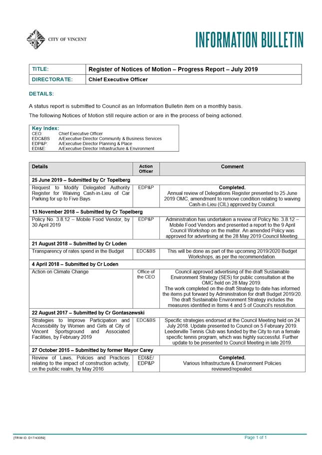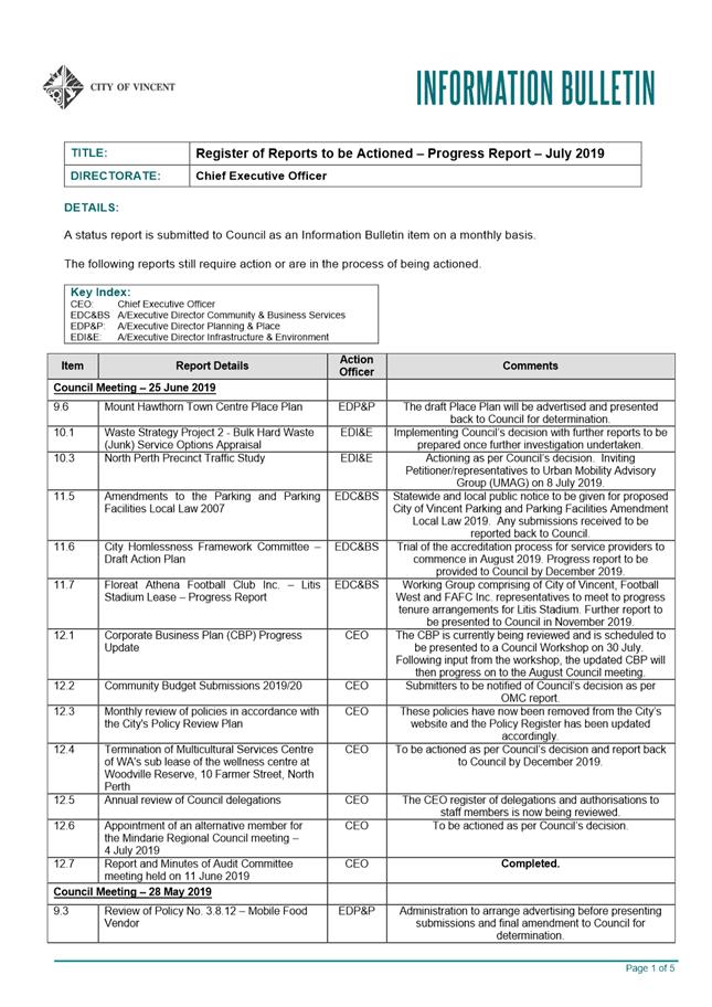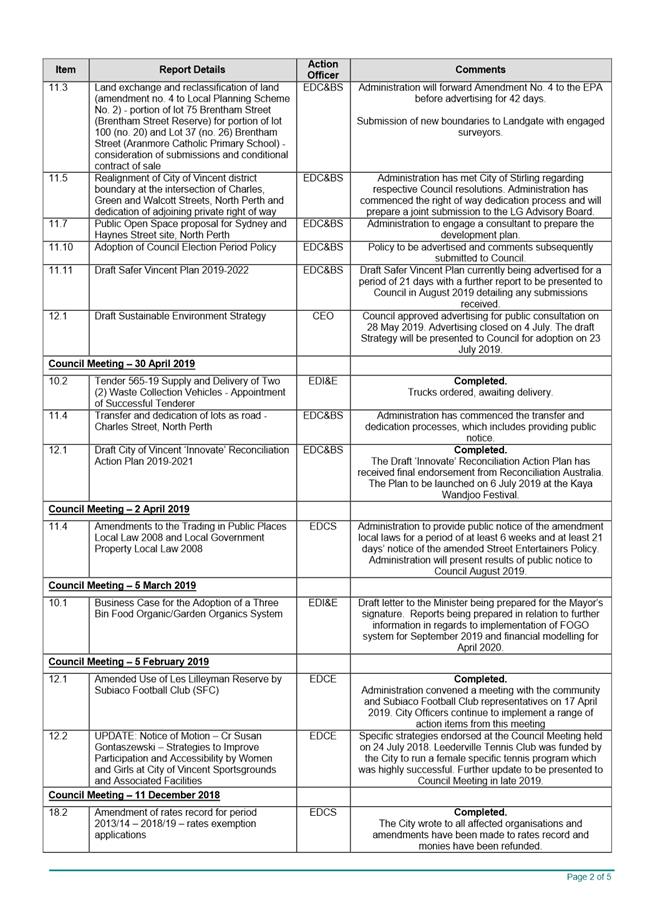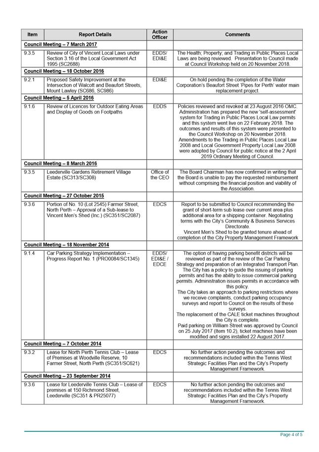
AGENDA
Council Briefing
16 July 2019
|
Time: |
6pm |
|
Location: |
Administration and Civic Centre 244 Vincent Street, Leederville |
David MacLennan
Chief Executive Officer
AGENDA
Council Briefing
16 July 2019
|
Time: |
6pm |
|
Location: |
Administration and Civic Centre 244 Vincent Street, Leederville |
David MacLennan
Chief Executive Officer
Council Briefing Agenda 16 July 2019
DISCLAIMER
No responsibility whatsoever is implied or accepted by the City of Vincent (City) for any act, omission, statement or intimation occurring during Council Briefings or Council Meetings. The City disclaims any liability for any loss however caused arising out of reliance by any person or legal entity on any such act, omission, statement or intimation occurring during Council Briefings or Council Meetings. Any person or legal entity who acts or fails to act in reliance upon any statement, act or omission made in a Council Briefing or Council Meeting does so at their own risk.
In particular and without derogating in any way from the broad disclaimer above, in any discussion regarding any planning or development application or application for a licence, any statement or intimation of approval made by an Elected Member or Employee of the City during the course of any meeting is not intended to be and is not to be taken as notice of approval from the City. The City advises that anyone who has any application lodged with the City must obtain and should only rely on WRITTEN CONFIRMATION of the outcome of the application, and any conditions attaching to the decision made by the Council in respect of the application.
Copyright
Any plans or documents contained within this Agenda may be subject to copyright law provisions (Copyright Act 1968, as amended) and that the express permission of the copyright owner(s) should be sought prior to their reproduction. It should be noted that Copyright owners are entitled to take legal action against any persons who infringe their copyright. A reproduction of material that is protected by copyright may represent a copyright infringement.
PROCEDURE FOR PUBLIC SPEAKING TIME
The City of Vincent Local Law Relating to Meeting Procedures prescribes the procedure for persons to ask questions or make public statements relating to a matter affecting the City, either verbally or in writing, at a Council meeting.
Questions or statements made at an Ordinary Council meeting can relate to matters that affect the City. Questions or statements made at a Special Meeting of the Council must only relate to the purpose for which the meeting has been called.
1. Shortly after the commencement of the meeting, the Presiding Member will ask members of the public to come forward to address the Council and to give their name and the suburb in which they reside or, where a member of the public is representing the interests of a business, the suburb in which that business is located and Agenda Item number (if known).
2. Public speaking time will be strictly limited to three (3) minutes per member of the public.
3. Members of the public are encouraged to keep their questions/statements brief to enable everyone who desires to ask a question or make a statement to have the opportunity to do so.
4. Public speaking time is declared closed when there are no further members of the public who wish to speak.
5. Questions/statements are to be directed to the Presiding Member and are to be made politely in good faith and are not to be framed in such a way as to reflect adversely or be defamatory on a Council Member or City Employee.
6. Where the Presiding Member is of the opinion that a member of the public is making a statement at a Council meeting, that does not affect the City, he may ask the person speaking to promptly cease.
7. Questions/statements and any responses will be summarised and included in the Minutes of the Council meeting.
8. Where practicable, responses to questions will be provided at the meeting. Where the information is not available or the question cannot be answered, it will be “taken on notice” and a written response will be sent by the Chief Executive Officer to the person asking the question. A copy of the reply will be included in the Agenda of the next Ordinary meeting of the Council.
9. It is not intended that public speaking time should be used as a means to obtain information that would not be made available if it was sought from the City’s records under Section 5.94 of the Local Government Act 1995 or the Freedom of Information (FOI) Act 1992. The CEO will advise the member of the public that the information may be sought in accordance with the FOI Act 1992.
RECORDING AND WEBSTREAMING OF COUNCIL MEETINGS
· All Ordinary and Special Council Meetings are electronically recorded except when the Council resolves to go behind closed doors;
· All recordings are retained as part of the City's records in accordance with the General Disposal Authority for Local Government Records produced by the Public Records Office;
· A copy of the recorded proceedings and/or a transcript of a particular section or all of a Council meeting is available in accordance with Policy No. 4.2.4 – Council Meetings – Recording and Web Streaming.
· Ordinary Meetings of Council and Council Briefings are streamed live on the internet in accordance with the City’s Policy – 4.2.4 - Council Meetings Recording and Web Streaming. It is another way the City is striving for transparency and accountability in what we do.
· The live stream can be accessed from http://webcast.vincent.wa.gov.au/video.php
· Images of the public gallery are not included in the webcast, however the voices of people in attendance may be captured and streamed.
· If you have any issues or concerns with the live streaming of meetings, please contact the City’s Manager Governance and Risk on 08 9273 6538.
Council Briefing Agenda 16 July 2019
1 Declaration of Opening / Acknowledgement of Country
2 Apologies / Members on Leave of Absence
3 Public Question Time and Receiving of Public Statements
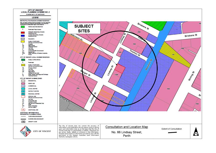
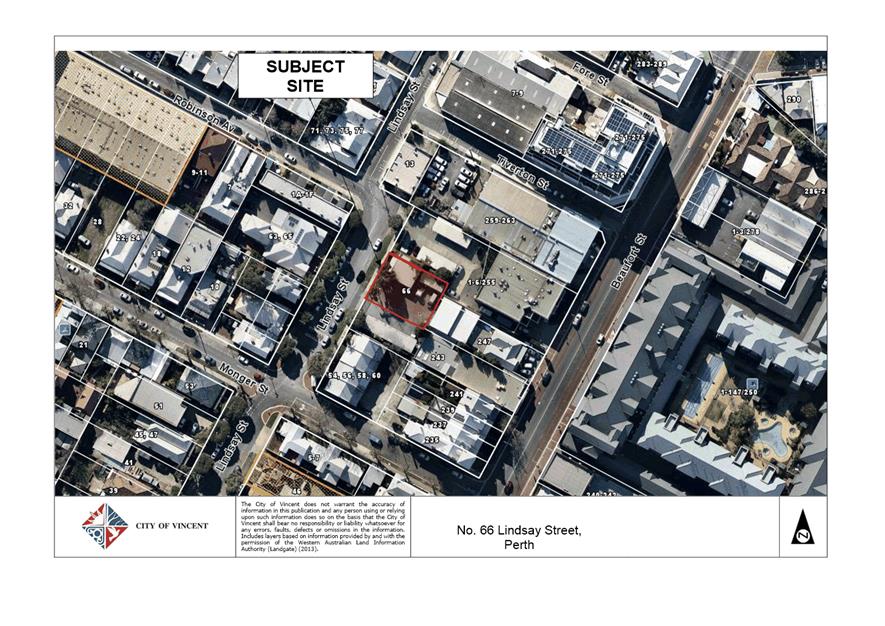
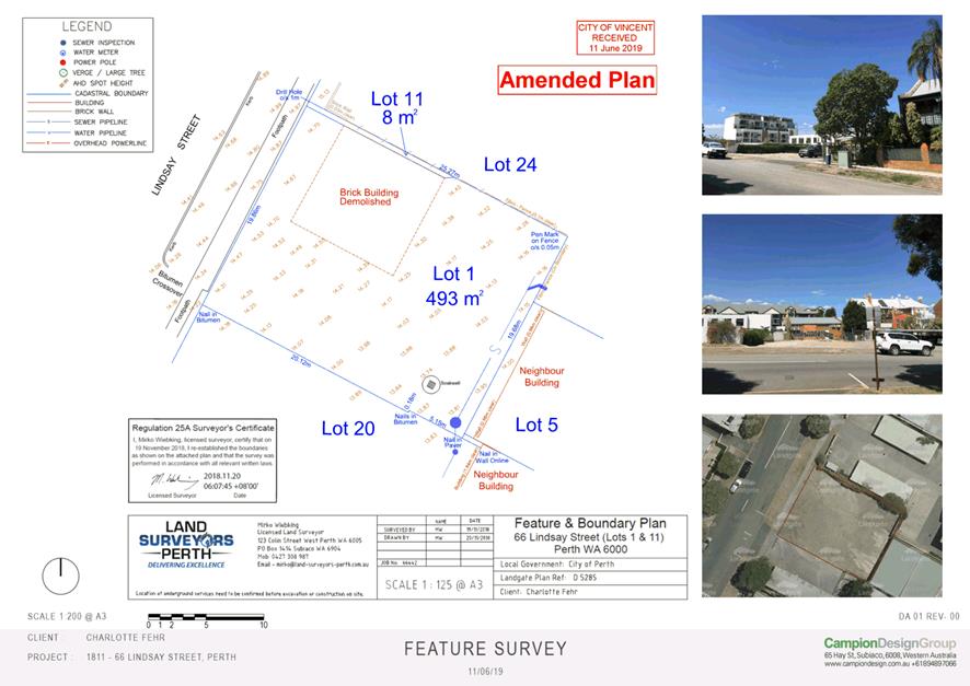
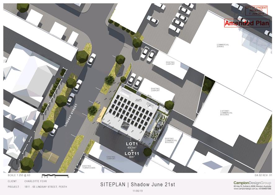
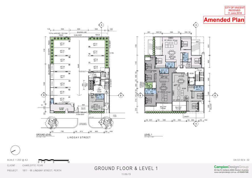
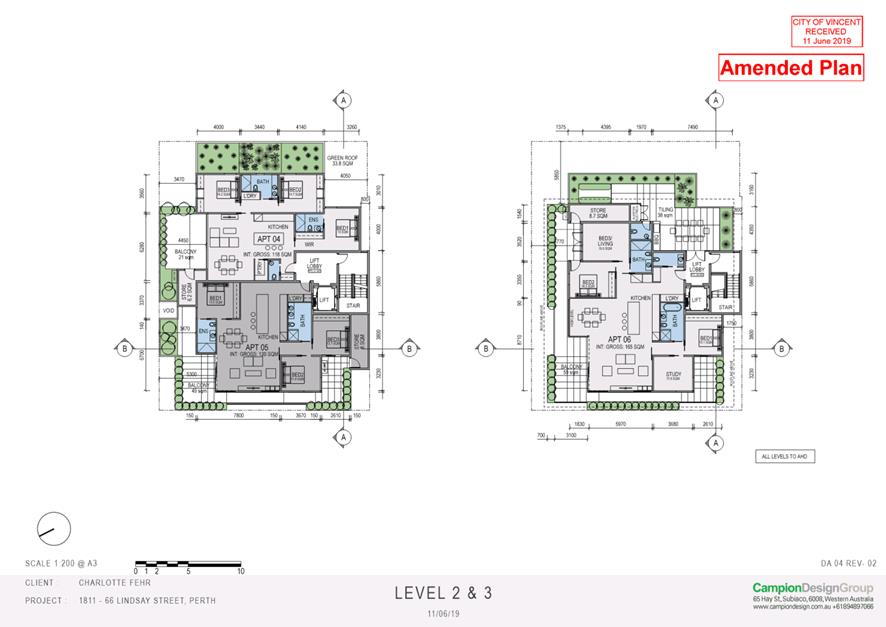
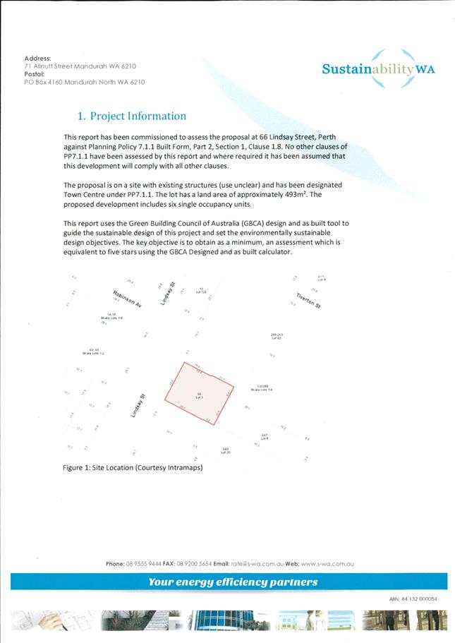
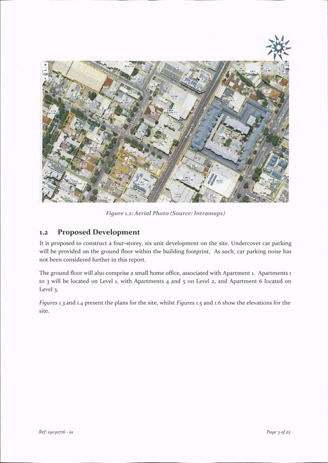
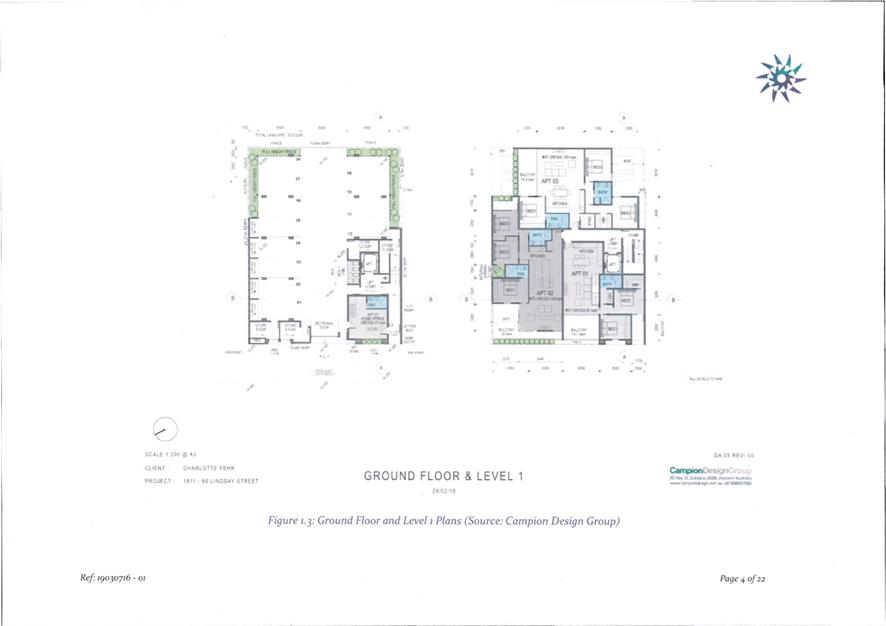
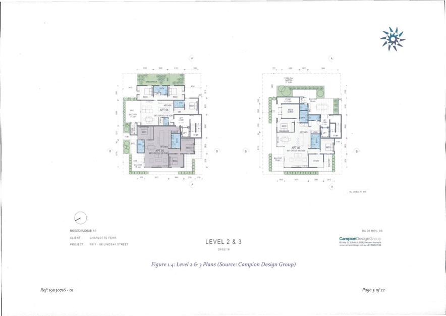
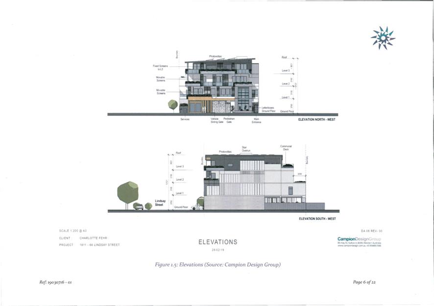
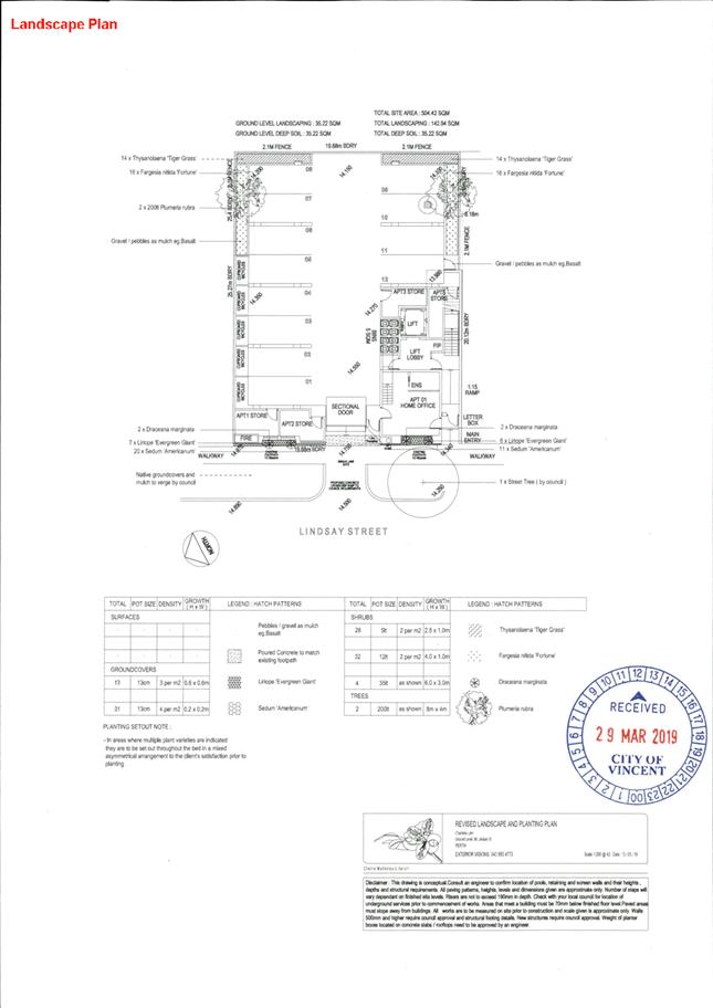
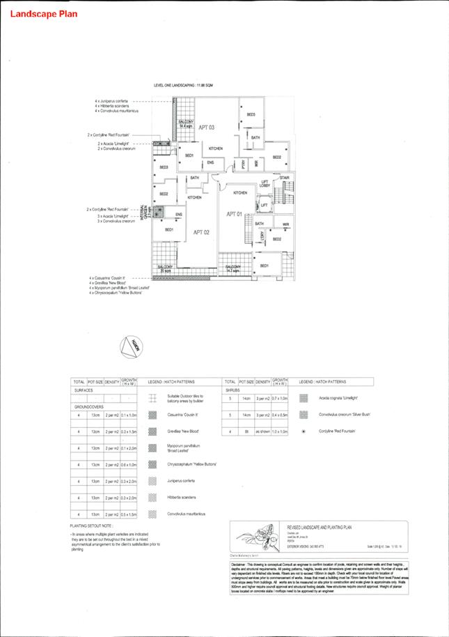
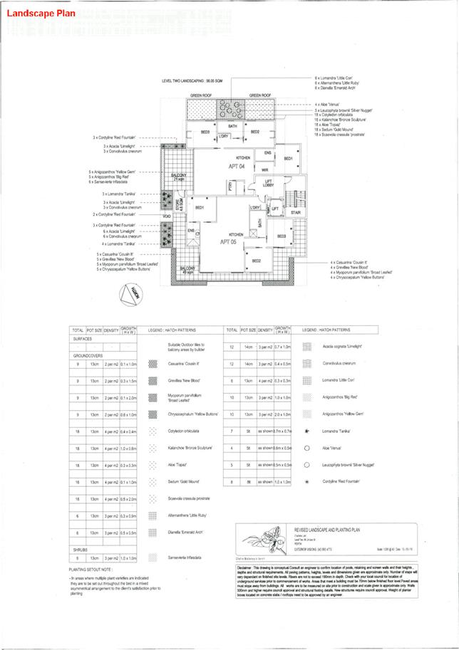
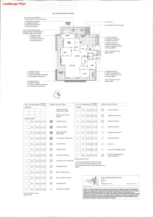
5.6 No. 66 (Lot: 1; D/P: 5285) Lindsay Street, Perth - Proposed Six Multiple Dwellings
5.8 Amendment to Policy No. 7.5.1 - Minor Nature Development
6 Infrastucture and Environment
7 Community and Business Services
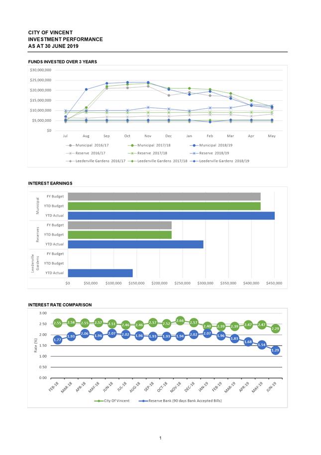
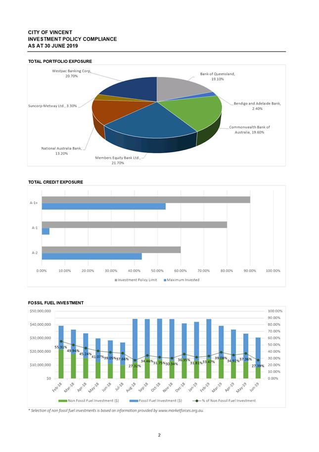
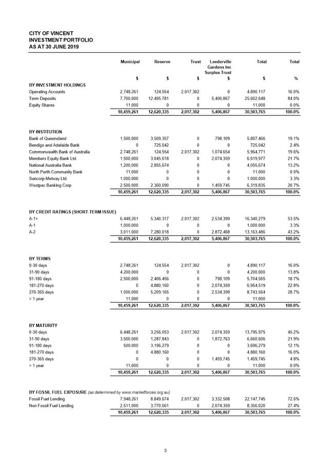
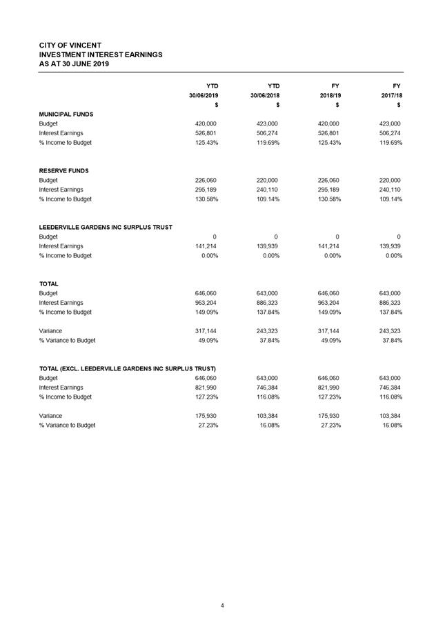
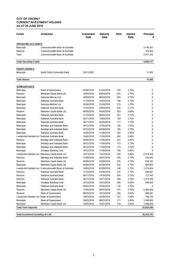
7.1 Investment Report as at 30 June 2019
7.2 LATE REPORT: Authorised Expenditure for the Period 1 June 2019 to 30 June 2019
7.3 LATE REPORT: Financial Statements as at 30 June 2019
9 Motions of Which Previous Notice Has Been Given
10 Representation on Committees and Public Bodies
“The City of Vincent would like to acknowledge the Traditional Owners of the land, the Whadjuk people of the Noongar nation and pay our respects to Elders past, present and emerging”.
2 Apologies / Members on Leave of Absence
2.1 Cr Susan Gontaszewski - approved leave of absence from 8 July 2019 to 21 July 2019 due to personal commitments.
2.2 Cr Josh Topelberg - Apology
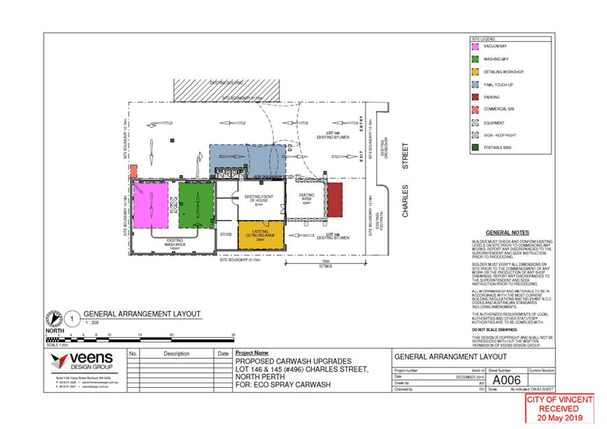
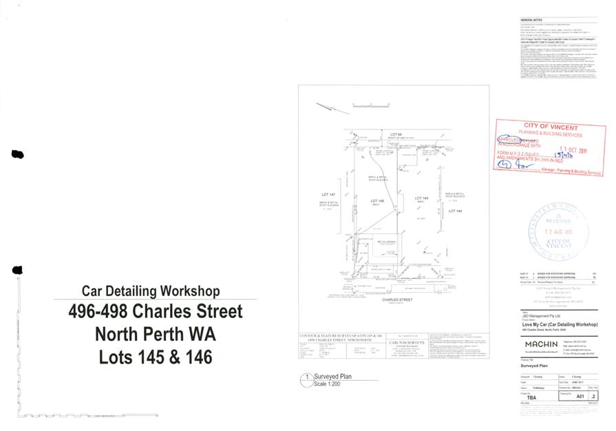
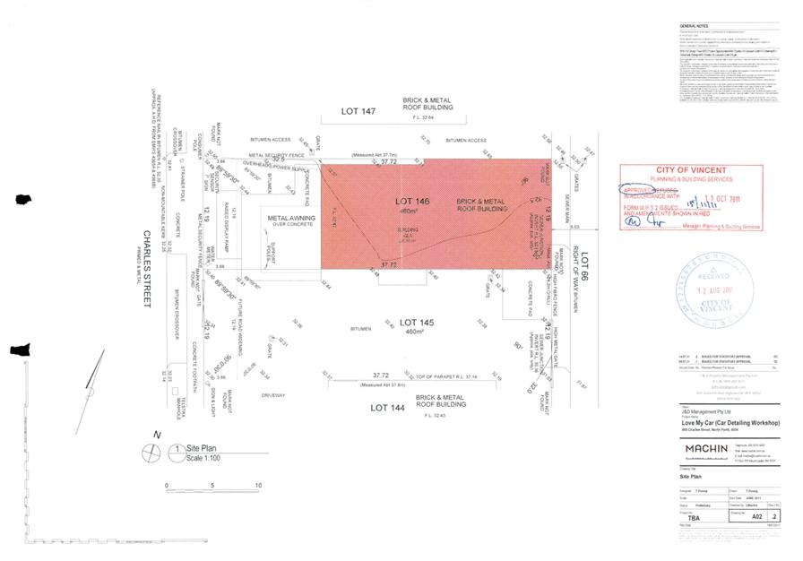
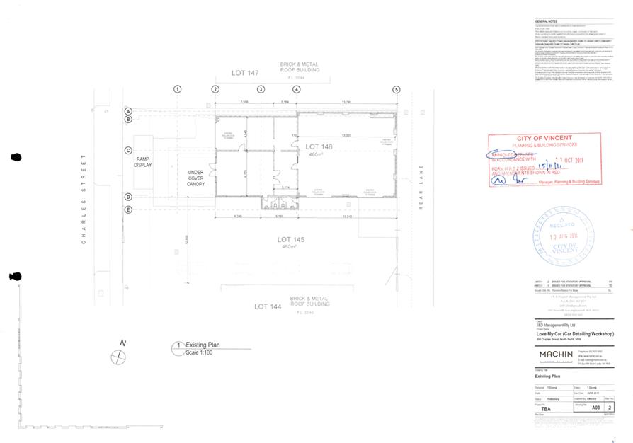
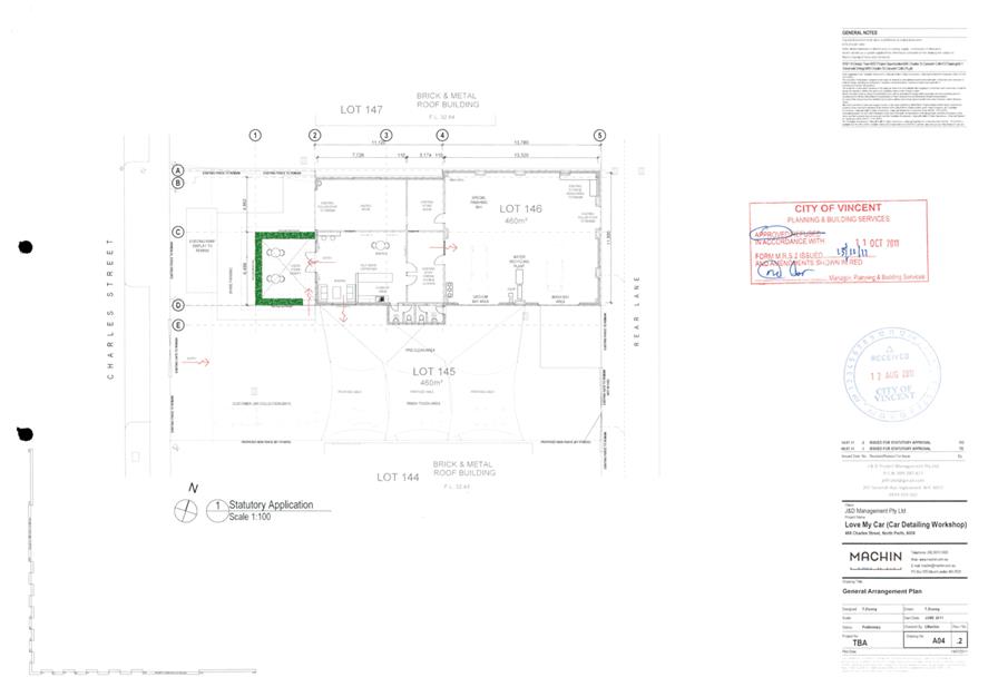
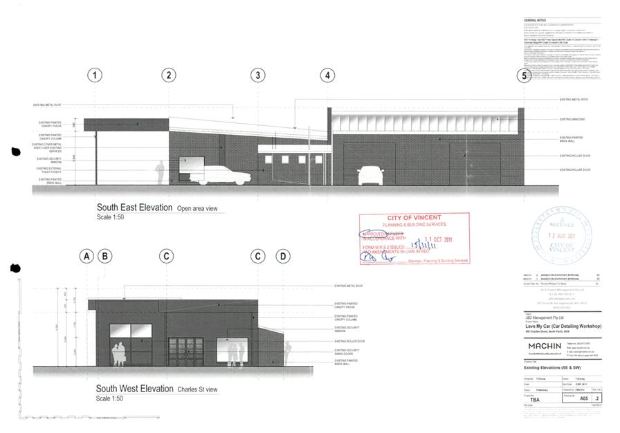
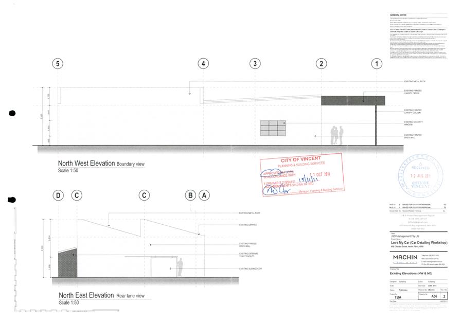
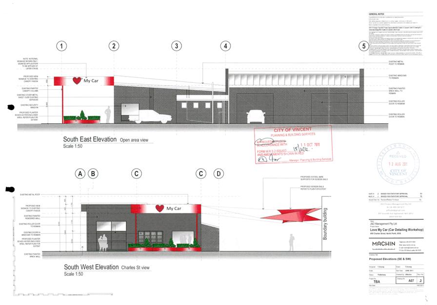
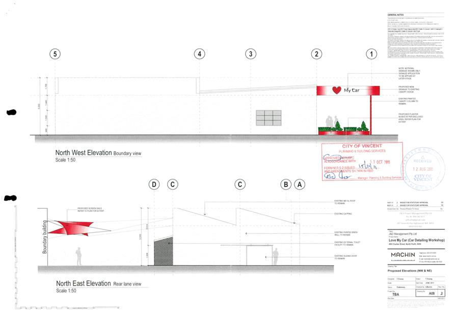
5.1 No. 496 (Lots: 145-146; D/P: 2630) Charles Street, North Perth - Change of Use to Unlisted Use Car Wash and Detailing (Amendment to Approved Operating Hours)
TRIM Ref: D19/83474
Author: Natasha Trefry, Urban Planning Advisor
Authoriser: Joslin Colli, Coordinator Planning Services
Ward: North
Attachments: 1. Consultation
and Location Map ⇩ ![]()
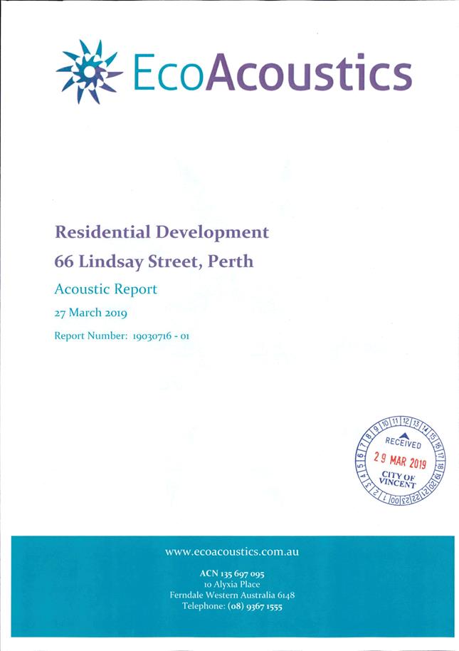
2. Acoustic Report ⇩ ![]()
3. Previous Council
Determination and Approved Plans - 11 October, 2011 ⇩ ![]()
4. Summary of
Submissions - Administration's Response ⇩ ![]()
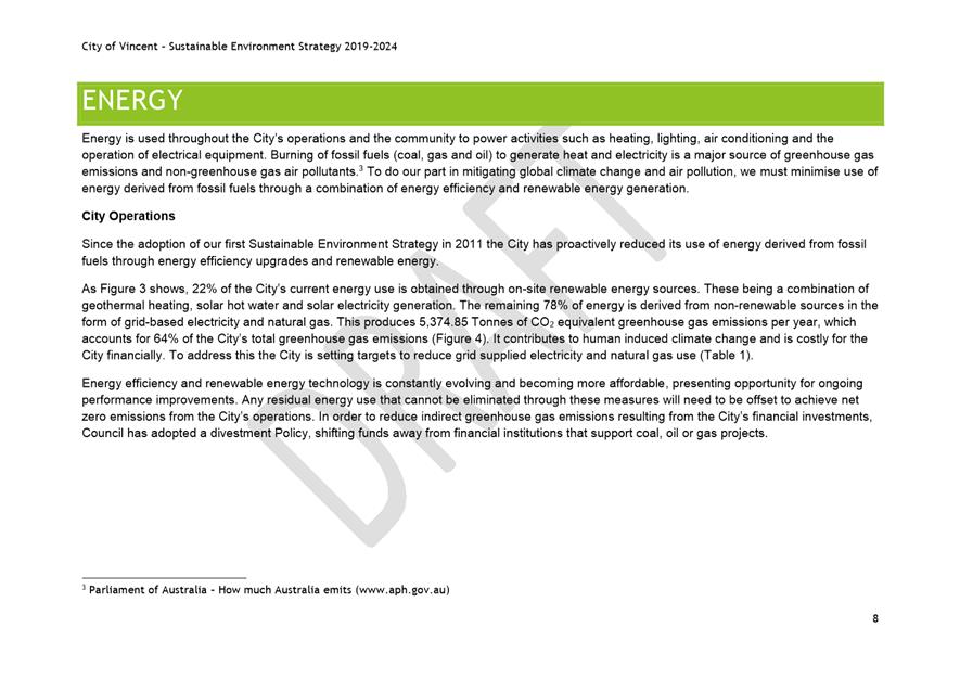
5. Summary of
Submissions - Applicant's Response ⇩ ![]()
6. Determination
Advice Notes ⇩ ![]()
|
That Council, in accordance with the provisions of the City of Vincent Local Planning Scheme No. 2 and the Metropolitan Region Scheme, APPROVES, the development application for Change of Use to Unlisted Use – Carwash and Detailing (Amendment to Approved) at No. 496 (Lots: 145‑146; D/P: 2630) Charles Street, North Perth, subject to the following conditions, with the associated advice notes in Attachment 6: 1. The hours of operation of the car wash and detailing use shall be: 1.1 7:00am to 7:00pm Monday to Friday; 1.2 7:00am – 5:30pm Saturday; and 1.3 8:30am to 5:00pm Sunday and public holidays (closed Christmas, Anzac Day and Good Friday); 2. The car wash and detailing use shall be limited to a maximum of three work station bays. Any increase in the number of work station bays or change of use for the subject land use shall require a separate Development Approval to be applied to and obtained from the City; 3. The use shall at all times operate in compliance with the Acoustic Report prepared by Herring Storer Acoustics dated 20 May and 10 June 2019. All recommended measures in the report shall be undertaken in accordance with the report to the City’s satisfaction, prior to the commencement of the extended operating hours use and maintained thereafter to the satisfaction of the City at the expense of the owners/occupiers; 4. Prior to the Commencement of the extended operating hours: Within 30 days of this approval the following shall be submitted and approved by the City: 4.1 Noise and Operational Management Plan The development shall, at all times, comply with the requirements of the Operational Management Plan. The operation shall be limited to the following and the Operational Management Plan shall be submitted to and approved by the City prior to commencement of the extended operating hours to include the following: 4.2 The hours of operation of the car wash and detailing use shall be limited to: 4.2.1 7:00am to 7:00pm Monday to Friday; 4.2.2 7:00am – 5:30pm Saturday; and 4.2.3 8:30am to 5:00pm Sunday; 4.3 Car wash and detailing services shall only occur at the three work station bays as identified on the approved plans; 4.4 An equipment inventory and maintenance schedule to ensure equipment is kept in good working order to minimise noise impacts; 4.5 A complaint management procedure including how complaints can be made and process for review and response; and 4.6 Restrictions on amplified music and other noise mitigation measures; 5. The use of the premises shall be carried out in accordance with the approved Noise and Operational Management Plan approved by the City. 5.1 The Noise and Operational Management Plan are to be reviewed: 5.1.1 Every 12 months; and 5.1.2 Within 30 days of a change of operator of the Car Wash and Detailing use; and 5.2 Any changes identified during a review as set out in condition 5.1 above, are to be incorporated into an updated Noise and Operational Management Plan, and approved by the City; and 5.3 The Car Wash and Detailing use must be operated in accordance with the Noise and Operational Management Plan (as amended from time to time) to the satisfaction of the City; and 6. All other aspects of the approved plans and all conditions and advice notes included in development approval 5.2011.395.1, granted on 11 October 2011, continue to apply to this approval. |
Purpose of Report:
To consider an application to extend the operating hours of the existing approved Unlisted Use (Car Wash) located at No. 496 Charles Street, North Perth (the subject site). The subject application was submitted in response to a compliance investigation that revealed the use was operating outside the approved trading hours.
PROPOSAL:
The application proposes to modify condition 5 of the existing approval relating to the approved operating hours of the Unlisted Use (Car Wash) as follows:
Approved operating hours
Monday to Friday 8:30am – 5:30pm;
Saturday 8:00am – 5:30pm;
Sunday 8:30am – 5:00pm.
Proposed operating hours
Monday to Friday 7:00am – 7:00pm;
Saturday 7:00am – 5:30pm;
Sunday and Public Holidays 8:30am – 5:00pm (unchanged).
Background:
|
Landowner: |
Dragan Kapinkoff |
|
Applicant: |
Gurjant Singh Sangha |
|
Date of Application: |
03 April 2019 |
|
Zoning: |
MRS: Urban LPS2: Commercial |
|
Built Form Area: |
Transit Corridor |
|
Existing Land Use: |
Unlisted Use (Car Wash) and Detailing |
|
Proposed Use Class: |
Unlisted Use (Car Wash) and Detailing |
|
Lot Area: |
460m² |
|
Right of Way (ROW): |
Yes – 5.0 metres |
|
Heritage List: |
No |
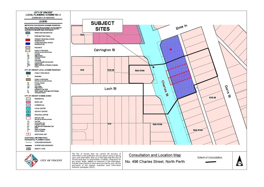
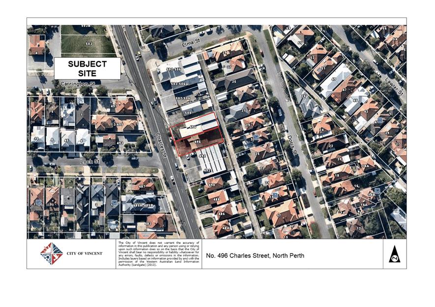
The subject site is No. 496 Charles Street, North Perth and comprised of Lot 145 and Lot 146. The site is zoned Commercial under the City’s Local Planning Scheme No. 2 (LPS2) and located within the Transit Corridor under Policy No. 7.1.1 – Built Form (Built Form Policy). The front setback area of the site, approximately 3.6 metres wide, is located within the Charles Street Planning Control Area.
The site is bordered by a commercial zoned property to the north, a laneway to the east, commercial zoned properties to the south and Charles Street to the west. The land on the opposite side of the laneway to the east is characterised by predominantly single storey single houses and grouped dwellings zoned Residential R30/R40. The land on the opposite side of Charles Street is zoned Residential R60-R100. A location map is provided in Attachment 1.
Council at its meeting 11 October 2011 granted conditional approval for an application (reference No. 5.2011.395.1) for a Change of Use to Unlisted Use (Car Wash and Detailing) and Associated Alterations and Additions at the subject site. The minutes of the 11 October 2011 Ordinary Council Meeting and approved development plans are included in Attachment 3.
The subject application only seeks to extend the operating hours of the premises, and no changes are proposed to the built form or land use.
In response to a number of complaints received by the City relating to the hours of operation and investigation by the City’s Compliance Services the applicant submitted a development application seeking approval for the extended operating hours. A development application is required as the current hours are conditioned on the development approval granted by Council.
Details:
Summary Assessment
The table below summarises the planning assessment of the proposal against the provisions of the City of Vincent Local Planning Scheme No. 2 (LPS2). In each instance where the proposal requires the discretion of Council, the relevant planning element is discussed in the Detailed Assessment section following from this table.
|
Planning Element |
Use Permissibility/ Deemed-to-Comply |
Requires the Discretion of Council |
|
Land Use (only where required) |
ü |
|
|
Operating Hours |
|
ü |
Consultation/Advertising:
Community Consultation was undertaken in accordance with the Planning and Development (Local Planning
Scheme) Regulations 2015, for a period of 14 days commencing on 30 April 2019 – 14 May 2019. Community consultation was undertaken by means of written notifications being sent to surrounding landowners, as shown in Attachment 1, a notice on the City’s website as well as a notice in a local newspaper.
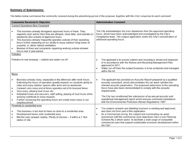
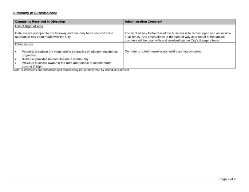
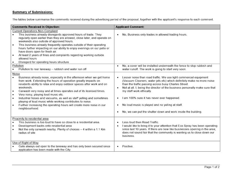
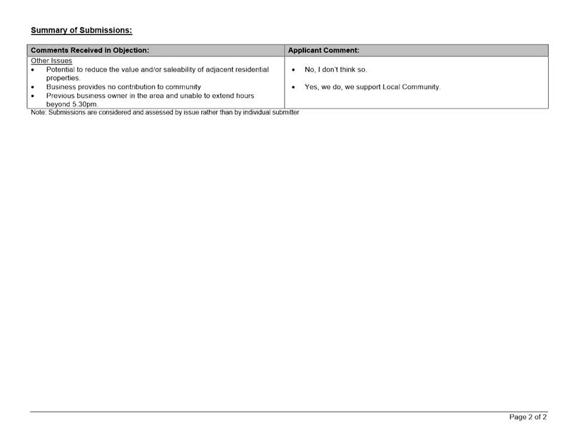
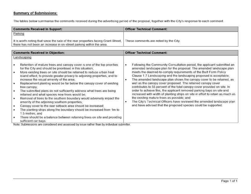
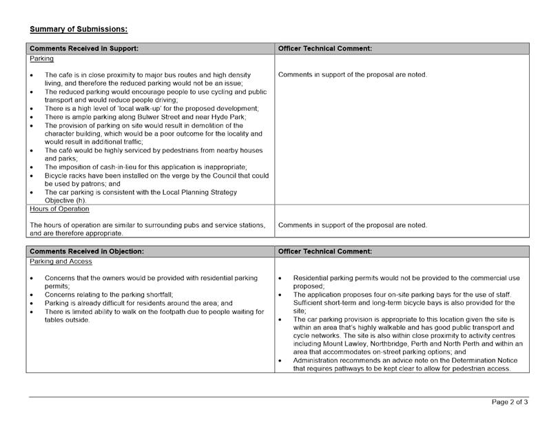
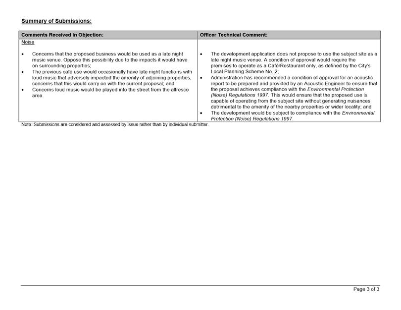
At the conclusion of the community consultation period, the City received a total of eight submissions comprising seven objections and one letter in support of the proposal. The issues raised as part of the consultation relate to the following:
· Pollution from business to the rear laneway;
· Noise generation;
· Proximity of the business to the residential area;
· Reduced value and saleability of adjacent residential properties.
A summary of the submissions and Administration’s comments on each issue is included as Attachment 4, with the applicants response to the submission included as Attachment 5.
Design Review Panel (DRP):
Referred to DRP: No
Legal/Policy:
· Planning and Development Act 2005;
· Planning and Development (Local Planning Schemes) Regulations 2015;
· City of Vincent Local Planning Scheme No. 2; and
· Policy No. 4.1.5 – Community Consultation;
Delegation to Determine Applications:
Council is required to determine the application as the original application was determined by Council and the delegation does not extend to applications to amend a development approval that was previously determined by Council.
Risk Management Implications:
There are minimal risks to Council and the City’s business function when Council exercises its discretionary power to determine a planning application.
Strategic Implications:
This is in keeping with the City’s Strategic Community Plan 2018-2028:
Innovative and Accountable
We are open and accountable to an engaged community.
SUSTAINABILITY IMPLICATIONS:
Nil.
Financial/Budget Implications:
Nil.
Comments:
Land Use
The subject site has approval as an Unlisted Use (Car Wash and Detailing). As an unlisted use, the business was given due consideration by Administration and Council in the determination of the original application in 2011. The approved land use and general operations of the business remain unchanged from the approval granted in 2011. No further consideration is given to the appropriateness of the existing land use at the subject site.
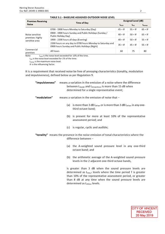
Noise Impacts
When the application was lodged the applicant sought approval to extend the hours of operation to 7:00am to 7:00pm Monday to Saturday and 8:30am to 5:00pm Sundays. Following advertising the applicant has revised the application amending the hours of operation to 8:00am to 5:30pm Saturday and 8:30am to 5:00pm Sundays. Monday to Friday remain unchanged from what was advertised.
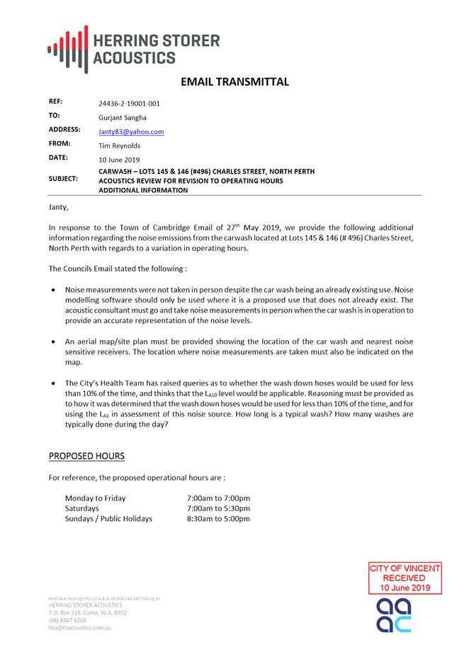
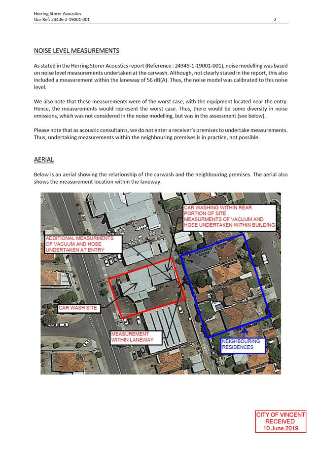
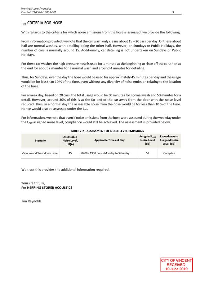
Objections were raised during community consultation regarding the additional hours and potential for additional noise emissions from the premises. The applicant submitted an acoustic report by a qualified acoustic consultant, Herring Storer Acoustics dated 20 May 2019 Attachment 2 in support of the proposed extended operating hours. The report was updated during the assessment and advertising process to provide additional noise measurements, and is also included as Attachment 2. The noise modelling undertaken for the premises was assessed on a worst case scenario basis from noise generated by both the vacuum and high pressure hoses during the existing and proposed operating hours. The acoustic report has been reviewed by the City and is considered to clearly demonstrate that the operation of the use for the proposed extended operating hours would be in compliance with the Environmental Protection (Noise) Regulations 1997.
A number of submissions were received relating to the amenity impacts resulting from the land use and particularly the non-compliance with approved hours. Council is not being asked to reconsider the appropriateness of the land use however, an extension to the operating hours has the potential to further impact on surrounding amenity and can be managed through appropriate conditions. A management plan was not required as part of the original application, as a result no detailed management measures are currently in place to manage the operation of the use. To ensure the use is appropriately managed and to limit adverse noise impacts on surrounding residents, a condition of approval is recommended that a Noise and Operational Management Plan is submitted to and approved by the City, prior to commencement of the extended hours. The management plan is required to include management measures relating to operating hours, the location of cleaning activities on the site, an equipment inventory and maintenance schedule, a complaints management procedure and other noise mitigating measures. Where complaints may arise as a result of the operations on site the City will be able to verify compliance with an approved Management Plan, where measures detailed in the Management Plan are not satisfactory the annual review of this plan will allow the operator to amend the management practices to mitigate potential impacts on the surrounding residential amenity.
An additional condition is recommended that the Management plan requires review and submission every 12 months. The condition is intended to allow the management plan to be reviewed in order to respond to any concerns received during the 12 month period and update the management measures to further protect the amenity of the surrounding area. The requirement to provide a management plan will result in an improvement of the management of the use as there is presently no detailed management measures in place.
Administration supports the extended trading hours subject to the additional conditions recommended.
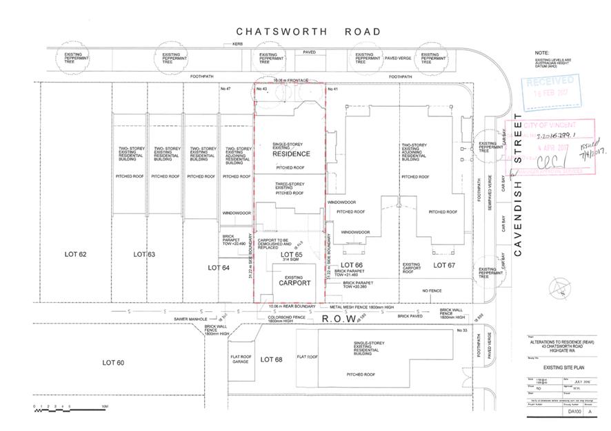
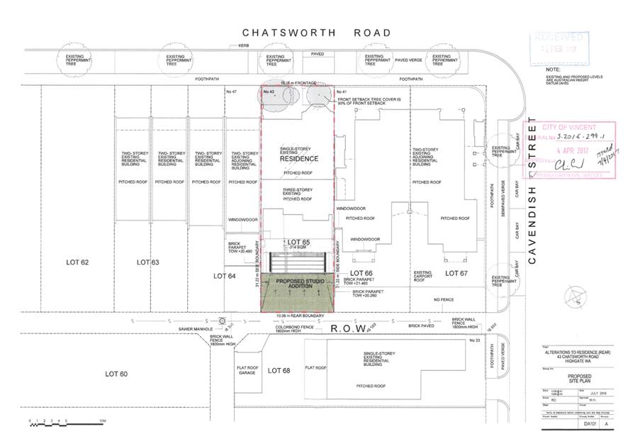
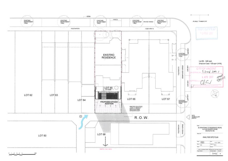
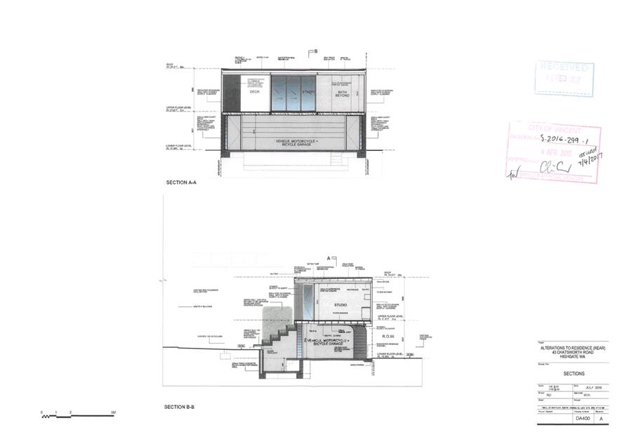
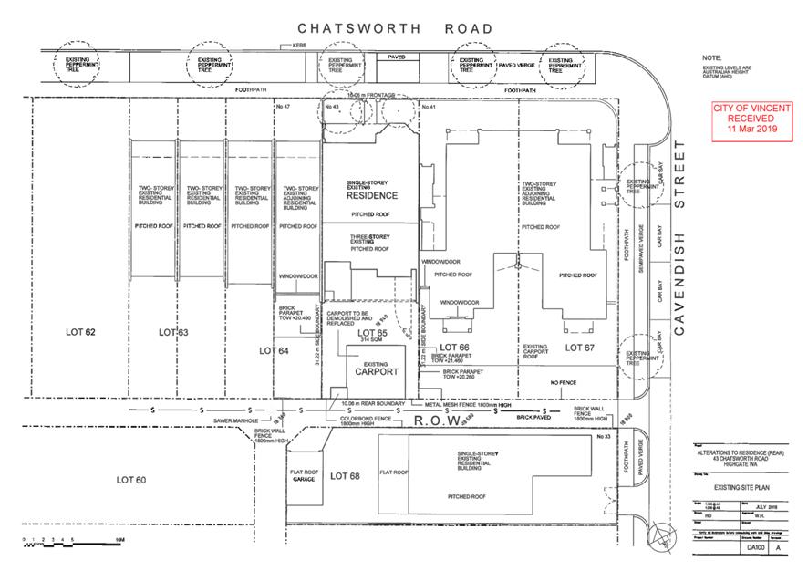
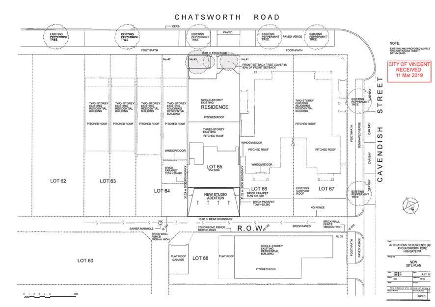
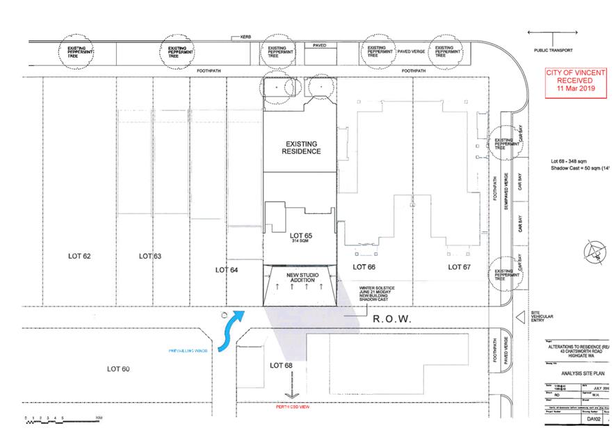
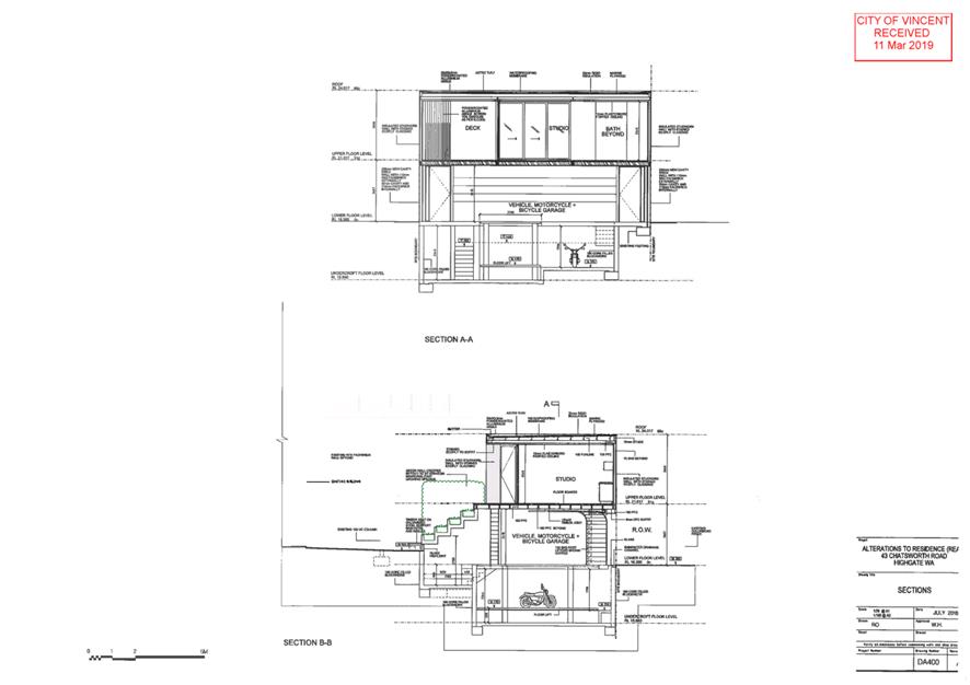
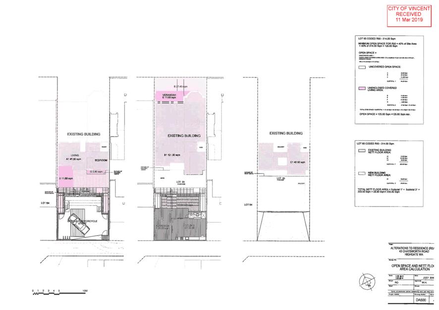
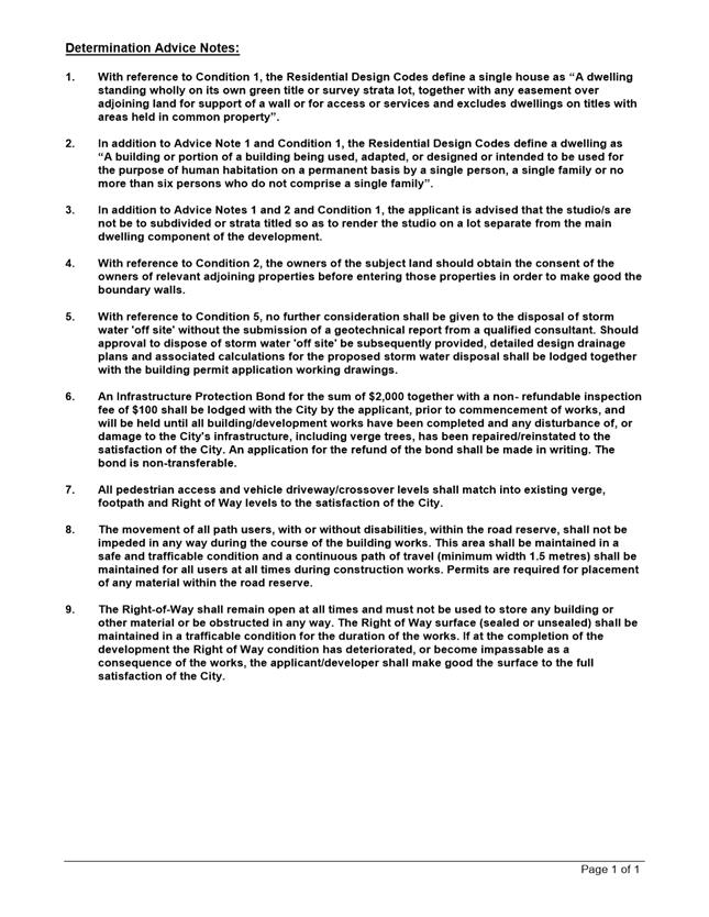
5.2 No. 43 (Lot: 65 D/P: 1106) Chatsworth Road, Highgate - Proposed Alterations and Additions to Single House (Amendment to Approval) and Extention to the Period of Approval
TRIM Ref: D19/80302
Author: Dan McCluggage, Urban Planner
Authoriser: Jay Naidoo, Manager Development & Design
Ward: South
Attachments: 1. Consultation
and Location Map ⇩ ![]()
2. Previous Approval
and Plans ⇩ ![]()
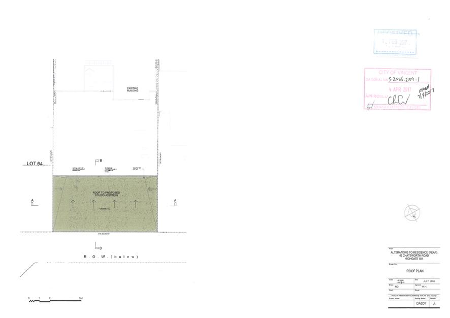
3. Development Plans
⇩ ![]()
4. Determination
Advice Notes ⇩ ![]()
|
That Council, in accordance with the provisions of the City of Vincent Local Planning Scheme No. 2 and the Metropolitan Region Scheme, APPROVES the application to amend a development approval for Alterations and Additions to Single House at No. 43 (Lot: 65; D/P: 1106) Chatsworth Road, Highgate, in accordance with the plans shown in Attachment 3 dated 11 March 2019, subject to the following conditions, with the associated determination advice notes in Attachment 4: 1. All conditions and advice notes detailed on the development approval 5.2016.299.1 granted on 4 April 2017 and included in Attachment 2 continue to apply to this approval, except as follows: 1.1 Condition 4 is amended to be Condition 4.1 and to read as follows: Adequate screening, in accordance with State Planning Policy 7.3: Residential Design Codes Volume 1, shall be provided to prevent overlooking from the deck area into the active habitable spaces and outdoor living areas of the property to the north west prior to the issue of a Building Permit and to the satisfaction of the City; 1.2 A new Condition 4.2 is imposed to read as follows: Adequate screening, in accordance with State Planning Policy 7.3: Residential Design Codes Volume 1, shall be provided to prevent direct overlooking from the deck area into the property to the south east prior to the issue of a Building Permit and to the satisfaction of the City; and 1.3 A new Condition 7 is imposed to read as follows: The extension of time to substantially commence the development is granted for a period of two years, being to 4 April 2021. |
Purpose of Report:
To consider an application for development approval for an amendment to a previous development approval for alterations and additions to a single house at No. 43 Chatsworth Road, Highgate (the subject site) and an extension to the period of approval.
PROPOSAL:
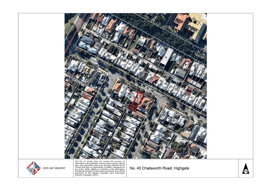
The subject site is located on the southern side of Chatsworth Road, Highgate, between Harley Street and Cavendish Street as shown in Attachment 1.
At its Ordinary Council Meeting held on 4 April 2017, Council approved a development application for alterations and additions to a Single House subject to conditions on the subject site. The development plans approved by Council are included as Attachment 2. This approval was valid for a period of two years and expired on 7 April 2019 at which time, the development was not substantially commenced. The current development application was lodged on 11 March 2019, prior to the expiration of the previous development approval.
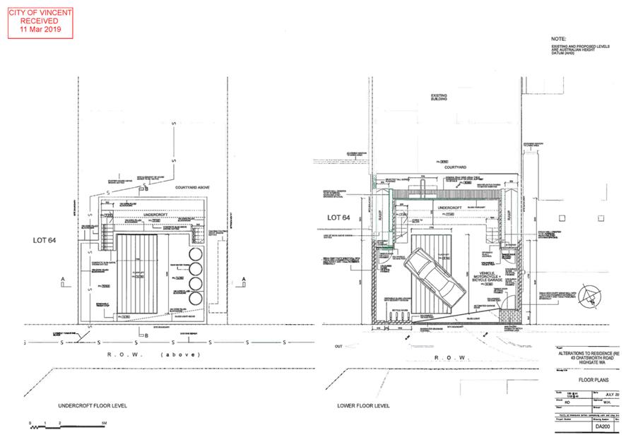
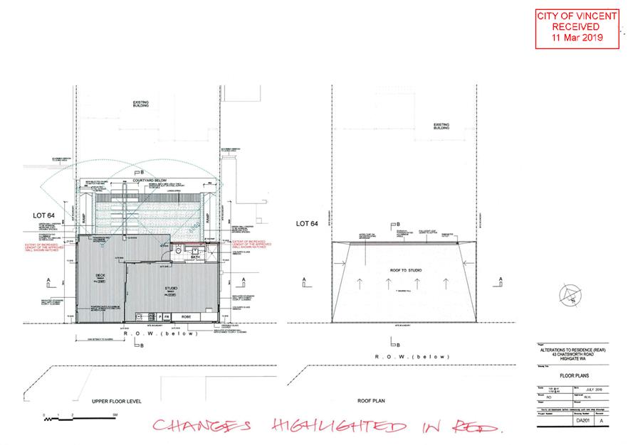
The application proposes to amend the previous approval by:
· Increasing the size of the upper floor deck and ensuite by 5.8 square metres;
· Incorporating an undercroft level beneath the ground floor garage fitted with a mechanical floor lift to accommodate vehicle, motorcycle and bicycle storage; and
· Extending the approval period to allow the applicant with an additional two years to substantially commence the development.
The proposed development plans are included as Attachment 3.
Background:
|
Landowner: |
Louis Cotter |
|
Applicant: |
Louis Cotter |
|
Date of Application: |
11 March 2019 |
|
Zoning: |
MRS: Urban LPS2: Zone: Residential R Code: R50 |
|
Built Form Area: |
Residential |
|
Existing Land Use: |
Single House |
|
Proposed Use Class: |
Single House |
|
Lot Area: |
314m² |
|
Right of Way (ROW): |
3.0m wide, City owned, sealed and drained |
|
Heritage List: |
No |
The surrounding area is zoned Residential R50 and is predominately characterised by single house developments although the development on the south eastern side of the subject site is a two storey multiple dwelling development.
At the rear of the subject site is a ROW which is 3.0 metres wide and informally used as a one way ROW with almost all vehicles that use the ROW travelling in a north westerly direction. The previous application approved the alterations and additions with a nil setback to the ROW and stated that no ROW widening was applicable on the basis that the subject site and adjoining sites were not large enough to subdivide or redevelop without amalgamation.
The previously approved development application was assessed against the relevant planning framework at the time including the City’s Policy No. 7.1.1 – Built Form (Built Form Policy) and the State Planning Policy 3.1 - Residential Design Codes (R Codes - now amended to be State Planning Policy 7.3 – Residential Design Codes Volume 1). The previous development application was approved with departures from the deemed-to-comply standards for lot boundary setbacks and ROW setbacks, and was conditionally approved to ensure that departures from the visual privacy deemed-to-comply standards in relation to the western lot boundary were addressed by adequate screening measures.
Details:
Summary Assessment
The table below summarises the planning assessment of the proposal against the provisions of the City of Vincent Local Planning Scheme No. 2 (LPS2), the City’s Policy No. 7.1.1 – Built Form and the State Government’s Residential Design Codes. In each instance where the proposal requires the discretion of Council, the relevant planning element is discussed in the Detailed Assessment section following from this table.
|
Planning Element |
Use Permissibility/ Deemed-to-Comply |
Previously approved |
Requires further Discretion |
|
Street Setback |
ü |
|
|
|
Lot Boundary Setback/Boundary Wall |
|
|
ü |
|
Building Height |
ü |
|
|
|
Open Space |
|
|
ü |
|
Outdoor Living Areas |
ü |
|
|
|
Landscaping |
ü |
|
|
|
Visual Privacy |
|
|
ü |
|
Parking & Access |
ü |
|
|
|
Solar Access |
ü |
|
|
|
Site Works/Retaining Walls |
ü |
|
|
|
Essential Facilities |
ü |
|
|
|
External Fixtures |
ü |
|
|
|
Surveillance |
ü |
|
|
|
Developments on Rights of Way |
|
ü |
|
Detailed Assessment
The deemed-to-comply assessment of the elements that require the discretion of Council is as follows:
|
Lot Boundary Setback/Boundary Wall |
|
|
Deemed-to-Comply Standard |
Proposal |
|
Residential Design Codes (R Codes) – Clause 5.1.3 Lot Boundary Setbacks
Aggregate boundary wall length of 17.4 metres to the north western lot boundary. |
Proposed Aggregate boundary wall length of 24.7 metres to the north western lot boundary.
|
|
|
Previously Approved Aggregate boundary wall length of 23.79 metres to the north western lot boundary. There is no change to the previously approved maximum and average wall height of 5.65 metres. |
|
Residential Design Codes (R Codes) – Clause 5.1.3 Lot Boundary Setbacks
Aggregate boundary wall length of 17.4 metres to the south eastern lot boundary.
|
Proposed Aggregate boundary wall length of 22.71 metres to the south eastern lot boundary.
|
|
|
Previously Approved Aggregate boundary wall length of 22.4 metres to the south eastern lot boundary. There is no change to the previously approved maximum and average wall height of 5.65 metres. |
|
Open Space |
|
|
Deemed-to-Comply Standard |
Proposal |
|
Residential Design Codes (R Codes) – Clause 5.1.4 Open Space
Minimum 40 percent open space. |
Proposed 38.3 percent open space.
Previously Approved 40 percent open space. |
|
Visual Privacy |
|
|
Deemed-to-Comply Standard |
Proposal |
|
Residential Design Codes (R Codes) – Clause 5.4.1 Visual Privacy
Upper floor deck cone of vision setback 7.5 metres to the north western lot boundary. |
Proposed 1.5 metres
Previously Approved 2 metres |
|
Residential Design Codes (R Codes) – Clause 5.4.1 Visual Privacy
Upper floor deck cone of vision setback 7.5 metres to the south eastern lot boundary. |
Proposed 3.5 metres
Previously Approved 5.4 metres |
The above elements of the proposal do not meet the specified deemed-to-comply standards and are discussed in the Comments section below.
Consultation/Advertising:
Community consultation was undertaken in accordance with the Planning and Development (Local Planning Schemes) Regulations 2015, for a period of 14 days commencing on 18 April 2019 and concluding on 7 May 2019. The method of consultation being 23 letters mailed to all owners and occupiers immediately adjacent to the subject site (as shown in Attachment 1) and a notice on the City’s website, in accordance with the City’s Policy No. 4.1.5 – Community Consultation.
No submissions were received following the conclusion of the community consultation period.
Design Review Panel (DRP):
Referred to DRP: No
Legal/Policy:
· Planning and Development Act 2005;
· Planning and Development (Local Planning Schemes) Regulations 2015;
· City of Vincent Local Planning Scheme No. 2;
· State Planning Policy 7.3 – Residential Design Codes Volume 1;
· Policy No. 4.1.5 – Community Consultation; and
· Policy No. 7.1.1 – Built Form Policy.
The application to amend an approval can be considered in accordance with Schedule 2, Part 9, Clause 77(1)(a) of the Planning and Development (Local Planning Schemes) Regulations 2015 and Clause 77(2)(b) allows the application to be made during or after the period within which the development must be substantially commenced. Clause 77(4) provides the local government the ability to approve the application with or without conditions or refuse the application.
Delegation to Determine Applications:
This matter is being referred to Council for determination as the proposal is for an amendment to a previous Council determination.
Risk Management Implications:
There are minimal risks to Council and the City’s business function when Council exercises its discretionary power to determine a planning application.
Strategic Implications:
This is in keeping with the City’s Strategic Community Plan 2018-2028:
Innovative and Accountable
We are open and accountable to an engaged community.
SUSTAINABILITY IMPLICATIONS:
Nil.
Financial/Budget Implications:
Nil.
Comments:
Acceptability of Extension of Time
The Planning and Development (Local Planning Schemes) Regulations 2015 enable the period within which a development approval must be substantially commenced to be extended. Whilst no guidance is provided in the Regulations as to how discretion can be exercised in this regard, the SAT has published several decisions that relate to the issue, which identify relevant considerations as follows:
1. Whether there have been any changes in the planning framework since the approval was granted;
2. Whether development is likely to receive approval now; and
3. If the applicant has actively and relatively conscientiously pursued the implementation of the development approval.
Each relevant matter is to be considered on balance in the exercise of discretion and is discussed below.
1. Changes to the planning framework
City of Vincent Local Planning Scheme No. 2
The previous application for the subject site was assessed under the City’s Town Planning Scheme No. 1 (TPS1) and associated policies. The City’s LPS2 was approved by the Minister and was gazetted on 16 May 2018. LPS2 resulted in no changes to the subject site’s Residential R50 zoning.
City of Vincent Policy No. 7.1.1 – Built Form
On 13 December 2016, Council adopted the Built Form Policy, which was published and came into effect on 21 January 2017. The adoption of the Built Form Policy also resulted in several other polices being rescinded. The subject site is located with the Residential Built Form Area under the Built Form Policy. The previous application for the subject site was granted approval on 4 April 2017 and was assessed against the Built Form Policy.
State Planning Policy 7.3: Residential Design Codes Volume 1
On 2 March 2018 and 24 May 2019, the Western Australian Planning Commission (WAPC) gazetted amendments to the R Codes. It is noted that these changes do not affect the assessment of the subject application.
2. Whether the development is likely to receive approval now
Departures to the R Codes associated with changes proposed to the previously approved development are discussed below.
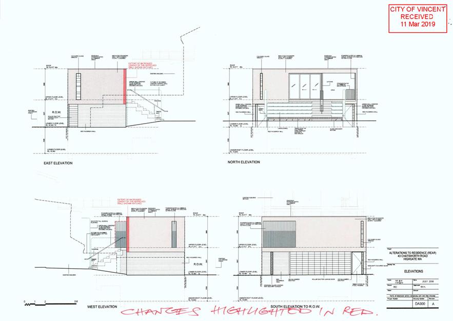
Boundary Walls
Walls built to two side boundaries are permitted under the Built Form Policy. The application incorporates two boundary walls to the north western and south eastern boundaries of the site. The aggregate lengths of each of these boundary walls result in a further departure than that previously approved by Council.
North Western Boundary Wall
The R Codes sets a deemed-to-comply standard of 17.4 metres aggregate boundary wall length to the north western lot boundary for the subject site. The previous development application was approved with an aggregate boundary wall length of 23.79 metres to the north western lot boundary and the current application proposes to increase the boundary wall length by an additional 0.91 metres to an aggregate of 24.7 metres.
The proposed north western boundary wall for the development is consistent with the design principles of the R codes for the following reasons:
· The proposed north western boundary wall abuts an area on the adjoining lot that has direct vehicle access from the ROW and is used for parking of vehicles;
· The primary outdoor living area of the north western lot is located in the rear yard. The boundary wall would not directly abut this outdoor living area;
· The proposed boundary wall would be constructed using contrasting materials and finishes and a vertical privacy screen which would provide visual interest and break up the appearance of building bulk to the north western lot boundary; and
· Due to the favourable orientation of the lots, the proposed boundary wall would not have an undue adverse impact on the adjoining north western property’s access to direct sun.
South Eastern Boundary Wall
The R Codes set a deemed-to-comply standard of 17.4 metres aggregate boundary wall length to the south eastern lot boundary for the subject site. The previous development application was approved with an aggregate boundary wall length of 22.4 metres to the north western lot boundary and the current application proposed to increase the boundary wall length by 0.31 metres to an aggregate of 24.7 metres.
The proposed south eastern boundary wall for the development is consistent with the design principles of the R Codes for the following reasons:
· The proposed south eastern boundary wall abuts an existing carport boundary wall on the adjoining lot and would not abut major openings to habitable rooms or outdoor living areas;
· The proposed boundary wall would be constructed using contrasting materials and finishes and a vertical window of colourful obscure glazing on the first floor which would provide visual interest and break up the appearance of building bulk to the south eastern lot boundary; and
· The proposed development satisfies the deemed-to-comply standard of the R Codes with regard to overshadowing and due to the orientation of the lot, the shadow that would be cast by the proposed alterations and additions would primarily fall on the ROW and the adjoining south eastern property’s vehicle access and car parking area.
Open Space
The application proposes to extend the previously approved upper floor deck and ensuite building footprint by 5.8 square metres towards the existing dwelling. This increased building footprint would reduce open space provided on-site. This is because the upper floor area sits above the ground floor garage. The definition of ‘open space’ in the R Codes does not include covered car parking spaces.
The R Codes sets a deemed-to-comply standard of minimum 40 percent open space for properties with an R50 density coding. The development previously approved provided 40 percent open space and the current application proposes to reduce the amount of open space by 1.7 percent to 38.3 percent.
The proposed open space for the development is consistent with the design principles of the R Codes for the following reasons:
· The proposed development would not have an adverse impact on the existing streetscape as it would be located to the rear of the existing dwelling, adjacent to the ROW at the rear of the site and would not be visible from the primary street;
· The proposed building footprint is generally consistent with that which was previously approved and would result in building bulk consistent with that reasonably expected for a Residential zoned site with an R50 density coding;
· The application provides for an uncovered outdoor living area between the existing dwelling and the proposed addition that satisfies the deemed-to-comply outdoor living area requirements set out in the R Codes;
· The application proposes to increase the floor area of the upper floor deck which has access to winter sunlight being open on the north western side and would be capable of use as an additional outdoor area;
· The abovementioned outdoor living area and upper floor deck would provide adequate space for the occupants of the dwelling to partake in on-site outdoor pursuits; and
· The dwelling is setback appropriately from the existing dwelling to allow for sufficient natural sunlight and ventilation.
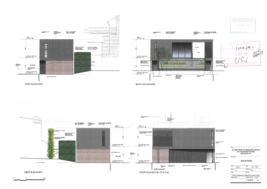
Visual Privacy
The R Codes set a deemed-to-comply standard of 7.5 metre cone of vision setbacks to adjoining properties for unenclosed outdoor active habitable spaces raised more than 0.5 metres above natural ground level. The application proposes a 1.5 metre cone of vision setback to the adjoining north western lot boundary and a 3.5 metre cone of vision setback to the adjoining south eastern lot boundary from the upper floor deck.
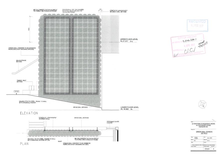
Visual Privacy – North West
The resulting overlooking would fall onto the adjoining north western property’s rear unenclosed outdoor living area and a major opening to a habitable room. This would not satisfy the relevant design principles of the R Codes. The previous application was approved with a condition for privacy screening to be provided to prevent overlooking from the deck to the outdoor living area and habitable room of the adjoining property. It is recommended that the condition imposed on the previous approval continues to apply to the current application to ensure that visual privacy to the north western property is maintained.
The applicant is proposing a landscaped green wall with a 1.2 metre setback to the north western lot boundary. The green wall plant species that has been proposed by the applicant is ‘kennedia nigricans’. It has been confirmed by the City’s Parks and Urban Green team that this species would be suitable for the purposes of screening as it is a vigorous native climbing plant. The benefit of using landscaping as a screening device rather than a solid brick wall is that it would result in less visual bulk and a better amenity outcome for the occupants of the subject property as well as adjoining properties. The species that has been selected is fast growing and would provide dense coverage suitable for screening purposes.
The applicant proposes that the green wall would have a height of 1.0 metre above the finished floor level of the upper floor deck which would not be sufficient to screen overlooking in accordance with the R Codes deemed-to-comply standard. The green wall would need to have a height of 1.6 metres above the finished floor level of the upper floor deck in order to satisfy the recommended condition.
With the implementation of the privacy screening recommended by Administration, the proposed overlooking to the south east meets the relevant deemed-to-comply standards of the R Codes and is supported.
Visual Privacy – South East
The edge of the upper floor deck and ensuite approved previously was flush with one another. This resulted in the ensuite acting as a privacy screen for the deck ensuring that overlooking in the direction of the south eastern lot boundary was oblique rather than direct. The current application proposes to extend the decking in such a way that the edge would no longer sit flush with the adjoining ensuite. This would result in direct overlooking to the adjoining south eastern property for this portion of the deck extension.
Administration recommends that a condition be imposed requiring privacy screening to be provided along the 0.5 metre portion of the deck extension that runs parallel to the south eastern lot boundary to ensure that overlooking in the direction of the adjoining property is oblique rather than direct. The remaining portion of overlooking to the south east would be consistent with the previous approval and would still satisfy the relevant design principles of the R Codes. This is because the resultant overlooking would fall onto a wall of the adjacent multiple dwellings without openings, and a 3 metre high boundary wall between the subject site and the adjacent multiple dwellings site.
With the implementation of the privacy screening recommended by Administration, the proposed overlooking to the south east meets the relevant design principles of the R Codes and is supported.
3. Implementation of the development
The applicant is seeking an extension of time to substantially commence works. The applicant has provided the following information outlining why the development was not substantially commenced prior to the expiration of the previous approval, and how the implementation of the development was pursued during this two year period:
“Since the original Planning Approval was granted by Council at its Ordinary Meeting on 4 April 2017 activities have included:
· Design development and documentation of the proposal;
· Structural advice and details for the construction;
· Tendering of the proposal to establish a construction cost; and
· Partial clearing of the rear yard to facilitate construction.
At that time the thought of excavating the basement was raised as a possible way to allow for more storage and on-site stormwater retention. This idea was explored with a supplier of the hoist needed, which was time consuming, as the manufacturer was Japanese, and communication was difficult. Subsequent activities included:
· Design development and documentation of the amended proposal to suit the standard hoist arrangement;
· Tendering of the hoist proposal to establish a cost for this element;
· Redesign to include a basement;
· Obtained specialist advice for the retention method for the below ground construction; and
· Lodgement of the amended DA in April 2019.
Whilst the development was not substantially commenced prior to the expiration of the previous approval, the applicant has demonstrated that efforts have been made in the implementation of the development during this time.
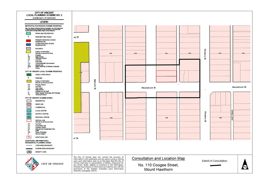
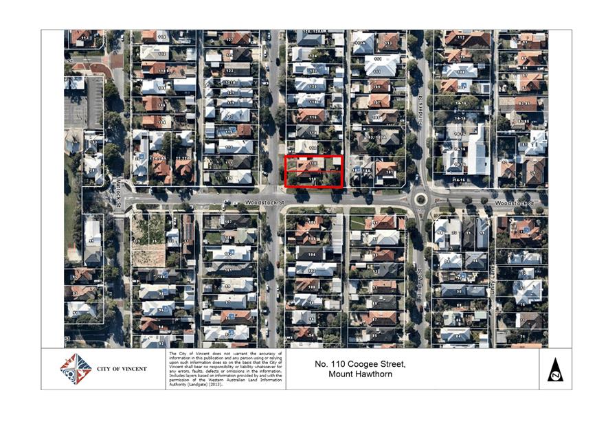
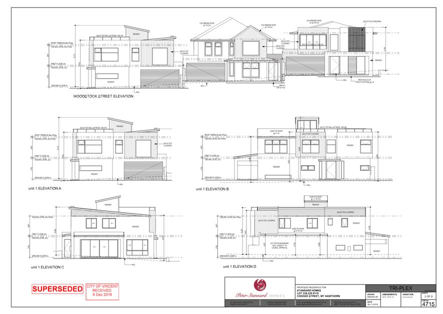
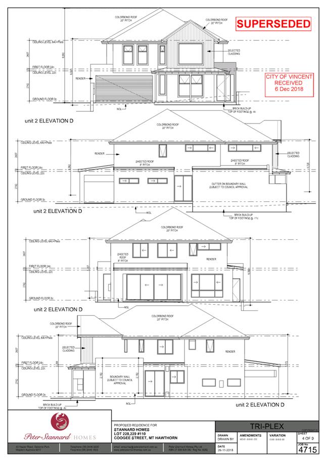
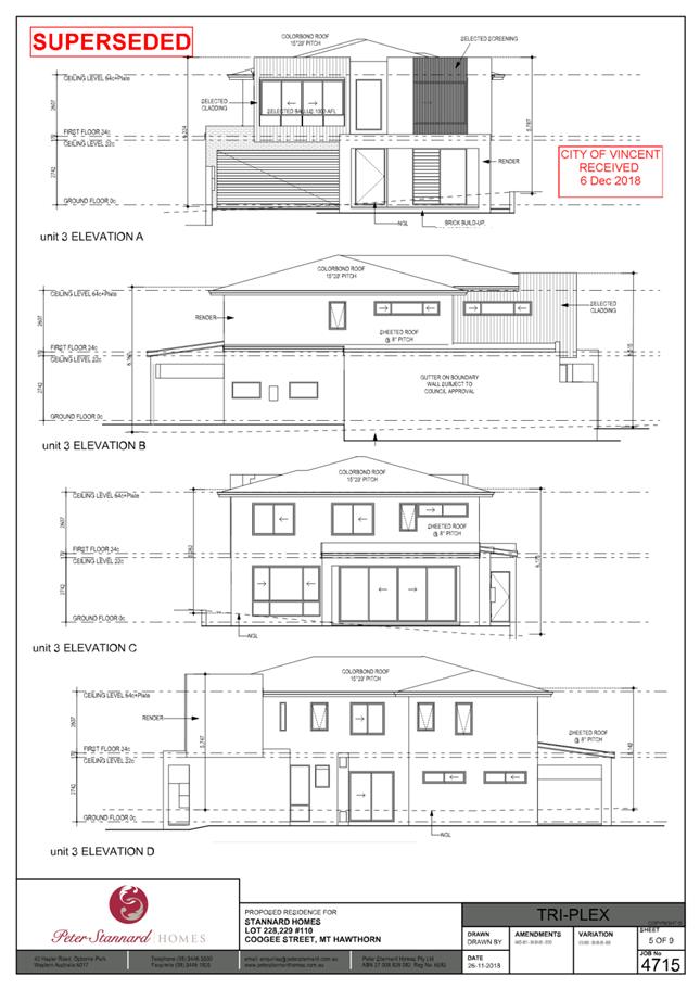
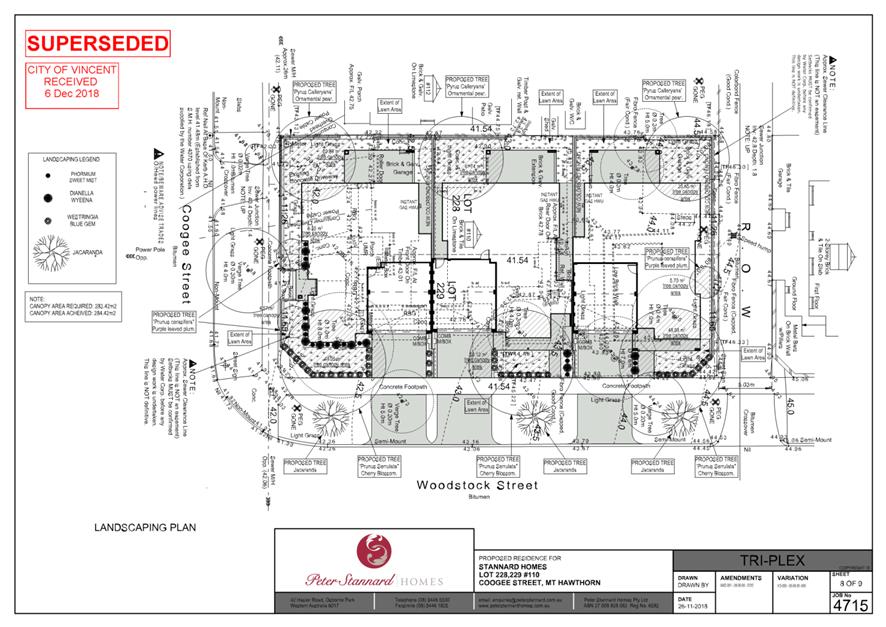
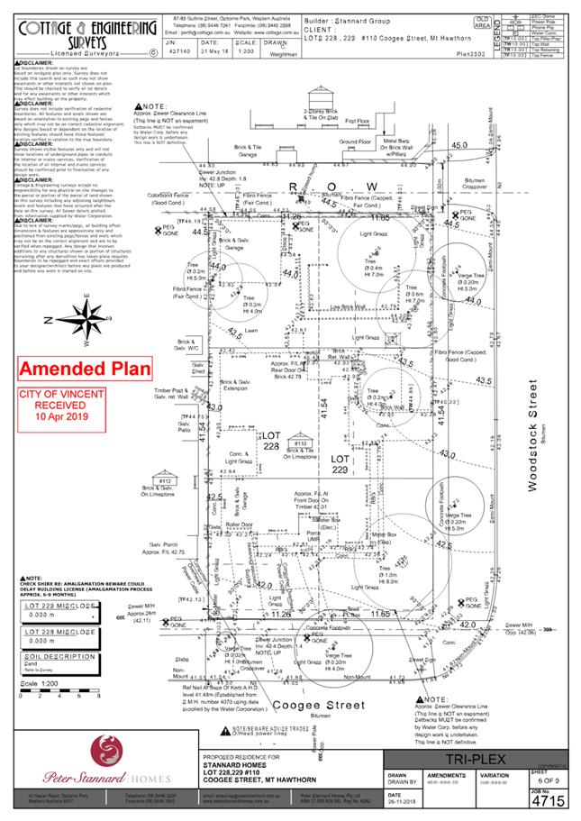
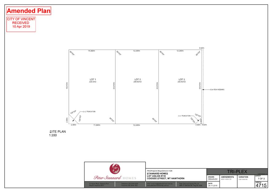
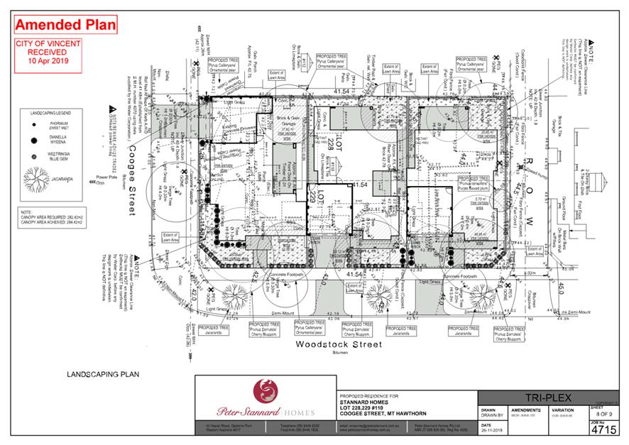
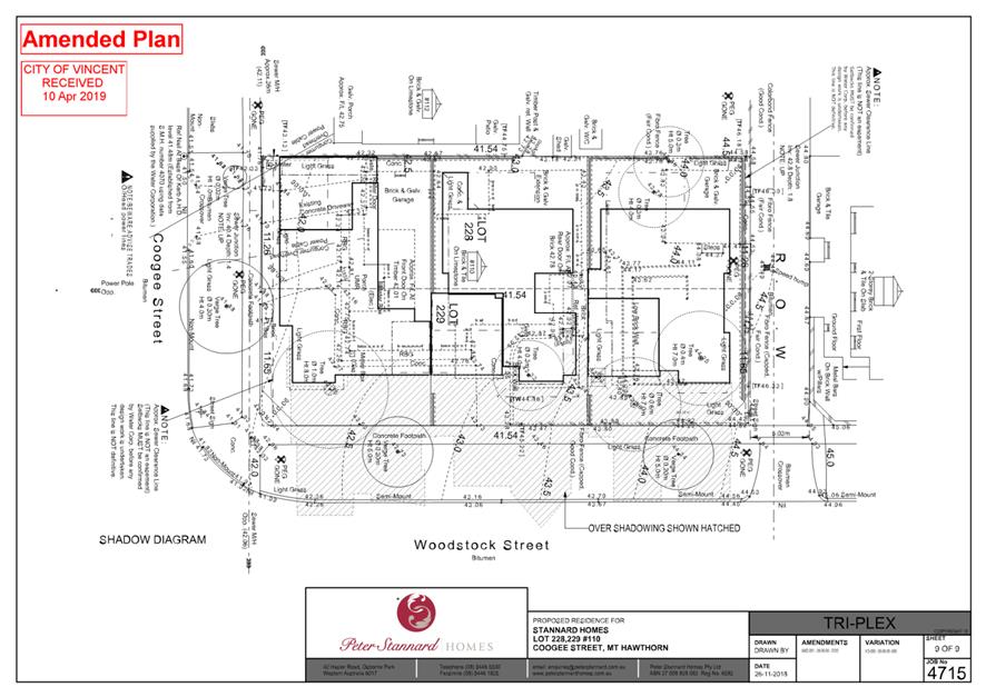
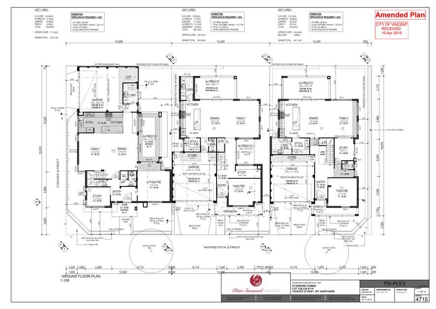
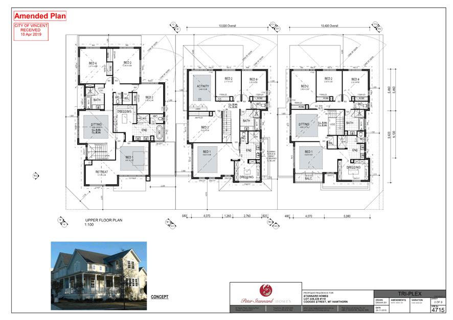
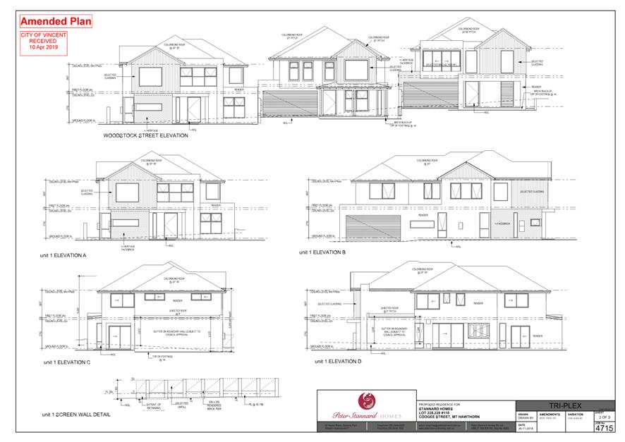
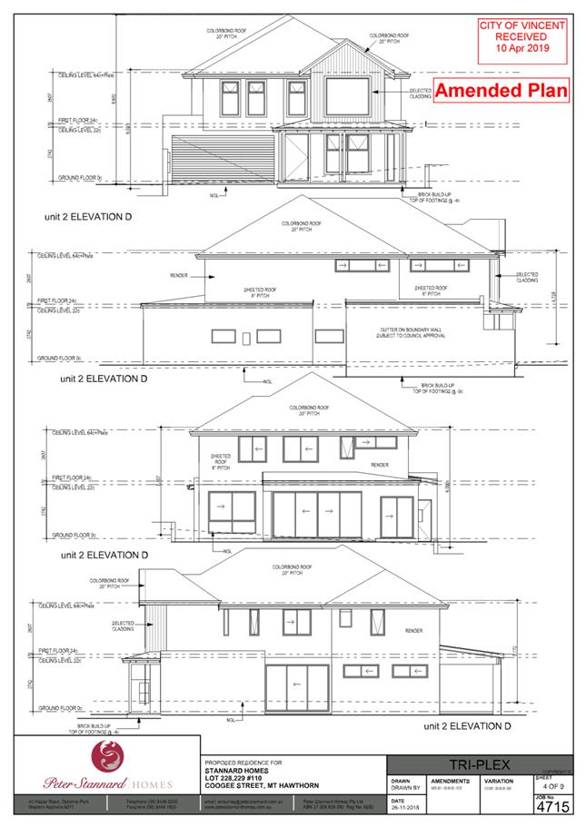
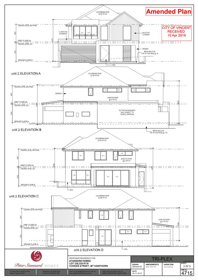
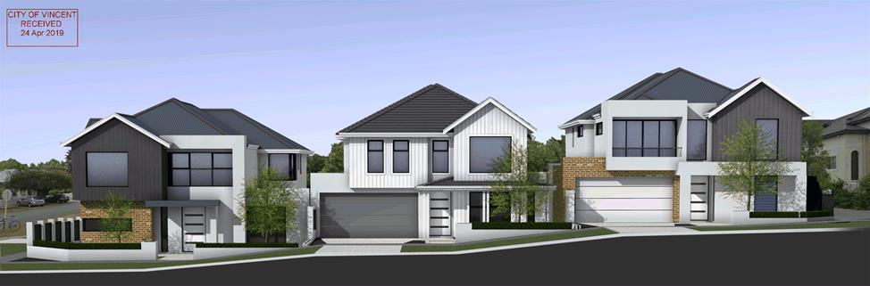
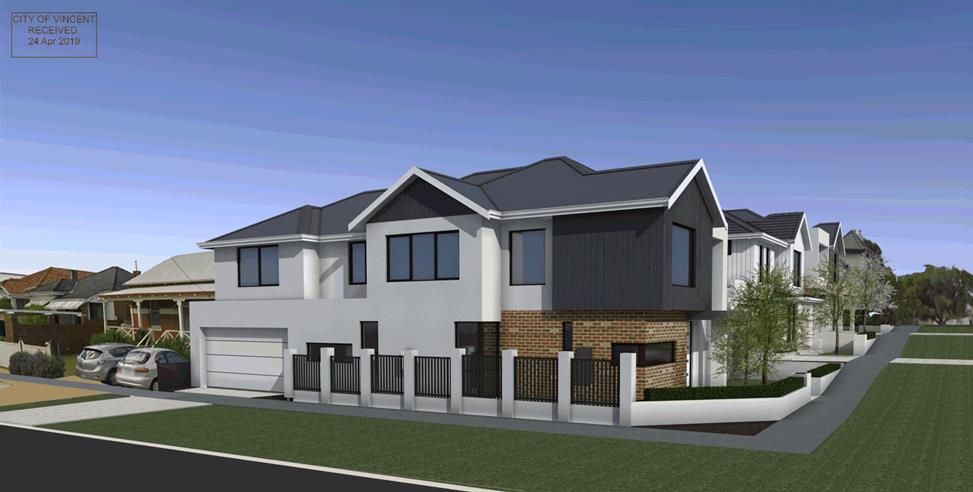
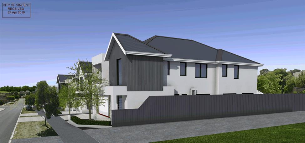
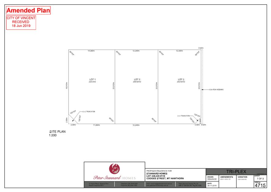
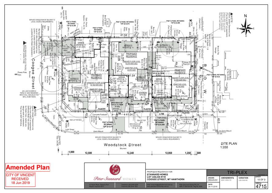
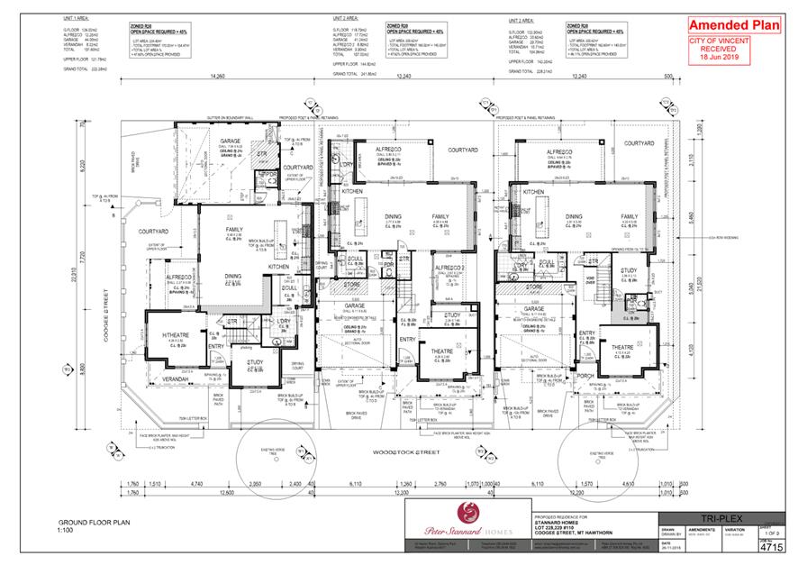
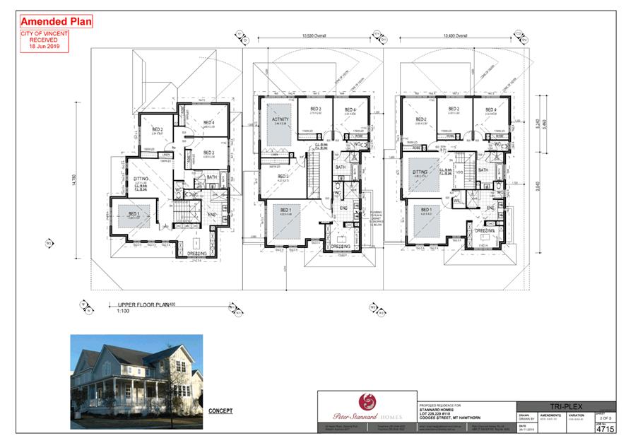
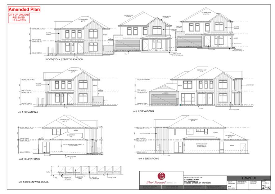
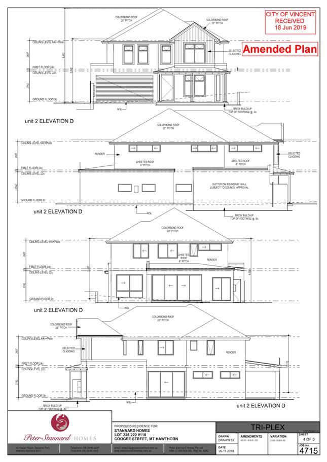
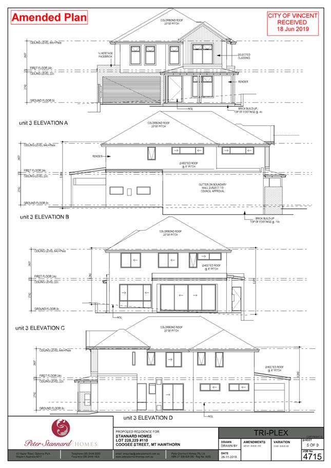
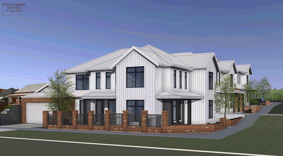
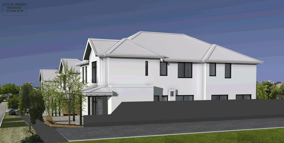
5.3 No. 110 (Lots: 228 and 229; D/P: 2503) Coogee Street, Mount Hawthorn - Proposed Three Grouped Dwellings
TRIM Ref: D19/17321
Author: Dan McCluggage, Urban Planner
Authoriser: Jay Naidoo, Manager Development & Design
Ward: North
Attachments: 1. Consultation
and Location Map ⇩ ![]()
2. Original Plans
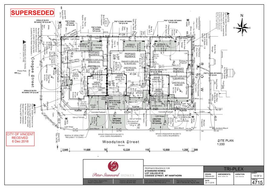
dated 6 December 2018 (Superseded) ⇩ ![]()
3. Plans Referred to
DRP Chairperson dated 10 April 2019 and 24 April 2019 (Superseded) ⇩ ![]()
4. Development Plans
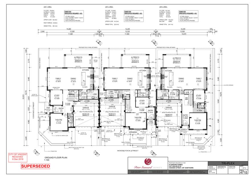
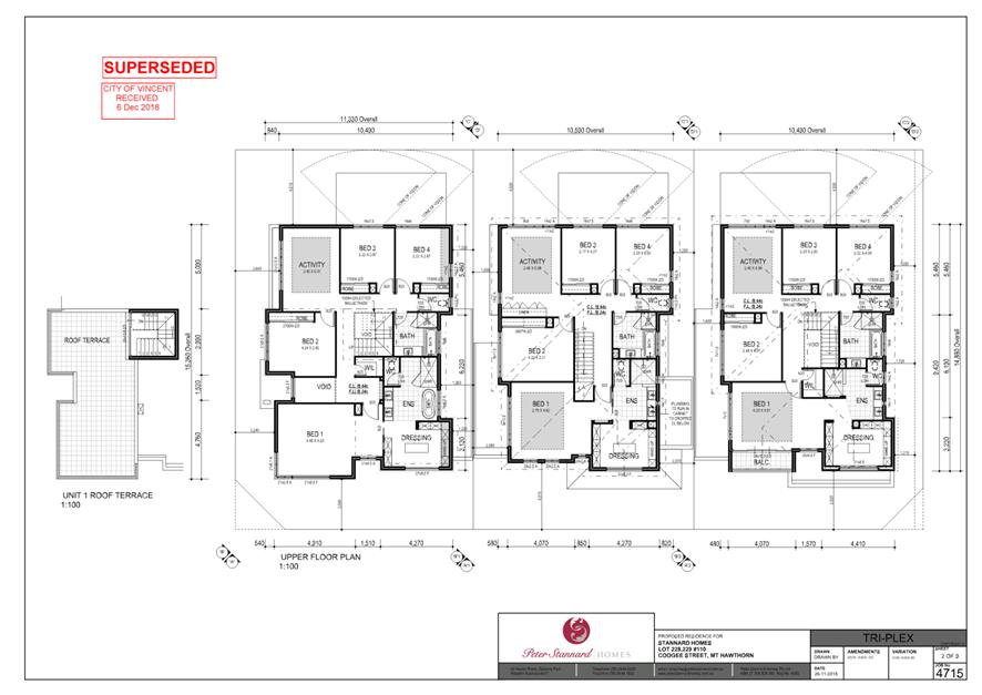
⇩ ![]()
5. Summary of
Submissions - Administration's Response ⇩ ![]()
6. Summary of
Submissions - Applicant's Response ⇩ ![]()
7. Determination
Advice Notes ⇩ ![]()
|
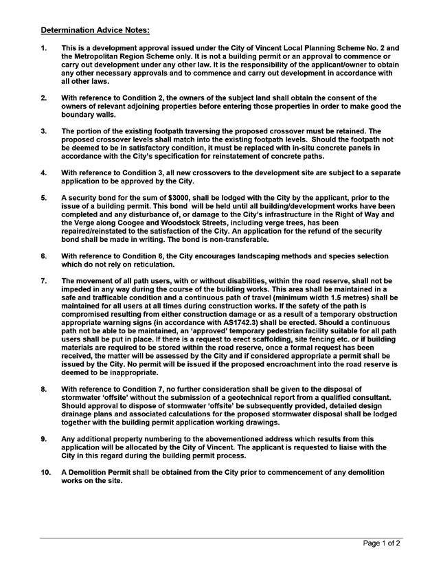
That Council, in accordance with the provisions of the City of Vincent Local Planning Scheme No. 2 and the Metropolitan Region Scheme, APPROVES the application for three Grouped Dwellings at No. 110 (Lots: 228 and 229; D/P: 2503) Coogee Street, Mount Hawthorn, in accordance with the plans shown in Attachment 4, subject to the following conditions, with the associated determination advice notes in Attachment 7: 1. Extent of Approval This approval is for three grouped dwellings as shown on the approved plans dated 18 June 2019 and 26 June 2019. No other development forms part of this approval; 2. Boundary Walls The owners of the subject land shall finish and maintain the surface of the boundary wall facing No. 112 Coogee Street in a good and clean condition prior to practical completion of the development to the satisfaction of the City. The finish of the boundary walls is to be fully rendered or face brickwork to the satisfaction of the City; 3. Car Parking and Access 3.1 The car parking and access areas shall be sealed, drained and paved in accordance with the approved plans and are to comply with the requirements of AS2890.1 prior to occupancy or use of the development; 3.2 Vehicle access points are required to match into existing footpath levels; and 3.3 All new crossovers shall be constructed in accordance with the City’s Standard Crossover Specifications; 4. Clothes Drying Facility All external clothes drying areas shall be adequately screened in accordance with State Planning Policy 7.3: Residential Design Codes Volume 1 prior to the use or occupation of the development and shall be completed to the satisfaction of the City;
5. External Fixtures All external fixtures, such as television antennas (of a non-standard type), radio and other antennaes, satellite dishes, solar panels, external hot water heaters, air conditioners, and the like, shall not be visible from the street(s), are designed integrally with the building, and be located so as not to be visually obtrusive; 6. Landscape and Reticulation Plan All works shown in the approved landscaping plans shall be undertaken in accordance with the approved plans to the City’s satisfaction, prior to occupancy or use of the development and maintained thereafter to the satisfaction of the City at the expense of the owners/occupiers; 7. Stormwater All stormwater produced on the subject land shall be retained on site by suitable means to the satisfaction of the City; 8. Street Walls and Fences The fencing infill panels above the approved solid portions of wall shall be visually permeable in accordance with State Planning Policy 7.3: Residential Design Codes Volume 1, to the satisfaction of the City; 9. Verge Tree With the exception of the verge tree that is in conflict with the Unit 1 crossover to Coogee Street, no other verge trees shall be removed without the prior written approval of the City. The verge trees shall be retained and protected from any damage including unauthorised pruning, to the satisfaction of the City; 10. Amalgamation of Lots Prior to the lodgement of a Building Permit application for the proposed development, Lot 228 and Lot 229 (‘The lots’) are to be amalgamated into a single lot on a Certificate of Title; or alternatively, the owner entering into a legal agreement with the City and secured by an absolute caveat lodged over the certificates of title to the Lots requiring the amalgamation to be completed within twelve months of the issue of a Building Permit for the proposed works; The owner shall be responsible to pay all costs associated with the City’s solicitor’s costs incidental to the preparation of (including all drafts) and stamping of the agreement and lodgement of the absolute caveat; 11. Visual Privacy Prior to occupancy or use of the development, all privacy screening shall be visually impermeable and is to comply in all respects with the requirements of Clause 5.4.1 of the Residential Design Codes (Visual Privacy) deemed to comply provisions, to the satisfaction of the City; 12. Sight Lines No walls, letterboxes or fences above 0.75 metres in height to be constructed within the 1.5 metre of where: 12.1 walls, letterboxes or fences adjoin vehicular access points to the site; or 12.2 a driveway meets a public street; or
12.3 two streets intersect; unless otherwise approved by the City of Vincent; 13. Truncations No development (including building, wall, fence or other form of visual obstruction) greater than 750mm in height measured from the natural ground level at the boundary, is to be placed on the lot within a 3 metre x 3 metre visual truncation at the intersection of Coogee Street and Woodstock Street, or within a 2 metre x 2 metre visual truncation at the intersection of Woodstock Street and the right of way; and 14. Right of Way Widening A 0.5 metre section of land shall be provided for right-of-way widening at the time of subdivision, in accordance with the approved development plan. The land required for right of way widening shall be transferred from the land owner to the Crown free of cost for the purpose of widening. |
Purpose of Report:
To consider an application for development approval for three grouped dwellings at No. 110 Coogee Street, Mount Hawthorn (the subject site). A location plan is included as Attachment 1.
PROPOSAL:
The application proposes three two-storey Grouped Dwellings in a side by side configuration. The front doors for all three dwellings would orientate towards Woodstock Street, and vehicle access would be from Coogee Street for Unit 1 and from Woodstock Street for Units 2 and 3.
Background:
|
Landowner: |
Stannard Enterprises Pty Ltd |
|
Applicant: |
Stannard Enterprises Pty Ltd |
|
Date of Application: |
6 December 2018 |
|
Zoning: |
MRS: Urban LPS2: Zone: Residential R Code: R30 |
|
Built Form Area: |
Residential |
|
Existing Land Use: |
Dwelling (Single) |
|
Proposed Use Class: |
Dwelling (Grouped) |
|
Lot Area: |
Lot 228: 483m2 Lot 229: 468m2 Total: 951m2 |
|
Right of Way (ROW): |
Yes – 5.0m wide, City owned, drained and sealed. |
|
Heritage List: |
No |
The subject site is located at No. 110 Coogee Street, Mount Hawthorn and currently contains a single-storey single house. The site is composed of two separate lots (Lots 228 and 229). The subject site is bounded by Coogee Street to the west, Woodstock Street to the south, a ROW to the east and a single-storey single house to the north at No. 112 Coogee Street. The broader area is generally characterised by single storey single houses with some examples of two storey single houses including the existing dwellings located across the ROW to the east.
The subject site is zoned Residential R30 under the City’s Local Planning Scheme No 2 (LPS2). The subject site and adjoining properties are within the Residential Built Form Area under the City’s Policy No. 7.1.1 – Built Form (Built Form Policy). The subject site would be subject to the City’s requirement for 0.5 metres of ROW widening along the ROW to the east, a 3.0 metre x 3.0 metre truncation at the junction of Woodstock and Coogee Streets, and a 2.0 metre x 2.0 metre truncation at the junction of Woodstock Street and the ROW.
The proposed development plans are included as Attachment 4.
Details:
Summary Assessment
The table below summarises the planning assessment of the proposal against the provisions of LPS2, the Built Form Policy and the State Government’s Residential Design Codes (R Codes). In each instance where the proposal requires the discretion of Council, the relevant planning element is discussed in the Detailed Assessment section following from this table.
|
Planning Element |
Use Permissibility/ Deemed-to-Comply |
Requires the Discretion of Council |
|
Site Area |
ü |
|
|
Street Setback |
ü |
|
|
Lot Boundary Setback |
ü |
|
|
Front Fence |
ü |
|
|
Sight Lines |
|
ü |
|
Building Height |
ü |
|
|
Open Space |
|
ü |
|
Outdoor Living Areas |
|
ü |
|
Landscaping |
ü |
|
|
Privacy |
ü |
|
|
Parking |
ü |
|
|
Vehicle Access |
|
ü |
|
Solar Access |
ü |
|
|
Site Works/Retaining Walls |
ü |
|
|
Essential Facilities |
ü |
|
|
External Fixtures |
ü |
|
|
Surveillance |
ü |
|
Detailed Assessment
The deemed-to-comply assessment of the elements that require the discretion of Council is as follows:
|
Open Space |
|
|
Deemed-to-Comply Standard |
Proposal |
|
R Codes Clause 5.1.4 Open Space
45 percent open space for an R30 site. |
Unit 2 proposes 43.5 percent open space. |
|
Sight Lines |
|
|
Deemed-to-Comply Standard |
Proposal |
|
R Codes Clause 5.2.5 Sight Lines
Walls, fences and other structures truncated or reduced to no higher than 0.75 metres within 1.5 metres of where walls, fences, other structures adjoin vehicle access points where a driveway meets a public street. |
There is an existing 1.37 metre high fence within the 1.5 metre x 1.5 metre sight line truncation area on the northern side of the proposed Unit 1 crossover between No 110 Coogee Street and No. 112 Coogee Street. |
|
Outdoor Living Areas |
|
|
Deemed-to-Comply Standard |
Proposal |
|
R Codes Clause 5.3.1 Outdoor Living Areas
An outdoor living area to be provided behind the street setback area. |
Unit 1 proposes the outdoor living area within the secondary street setback area. |
|
Vehicle Access |
|
|
Deemed-to-Comply Standard |
Proposal |
|
R Codes Clause 5.3.5 Vehicle Access
Access to on-site car parking spaces to be provided from a right of way where available. |
Unit 3 proposes vehicle access to the primary street. |
|
R Codes Clause 5.3.5 Vehicle Access
Driveways in aggregate no greater than 9.0 metres for any one property. |
Aggregate driveway width of 11.8 metres. |
The above elements of the proposal do not meet the specified deemed-to-comply standards and are discussed in the Comments section below.
Consultation/Advertising:
Community consultation was undertaken in accordance with the Planning and Development (Local Planning Schemes) Regulations 2015, for a period of 14 days commencing on 17 January 2019 and concluding on 4 February 2019. The method of consultation being 18 letters mailed to all owners and occupiers immediately adjacent to the subject site (as shown in Attachment 1) and a notice on the City’s website, in accordance with the City’s Policy No. 4.1.5 – Community Consultation. The plans that were advertised during this first round of consultation are included as Attachment 2.
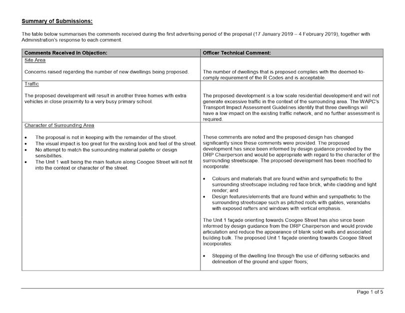
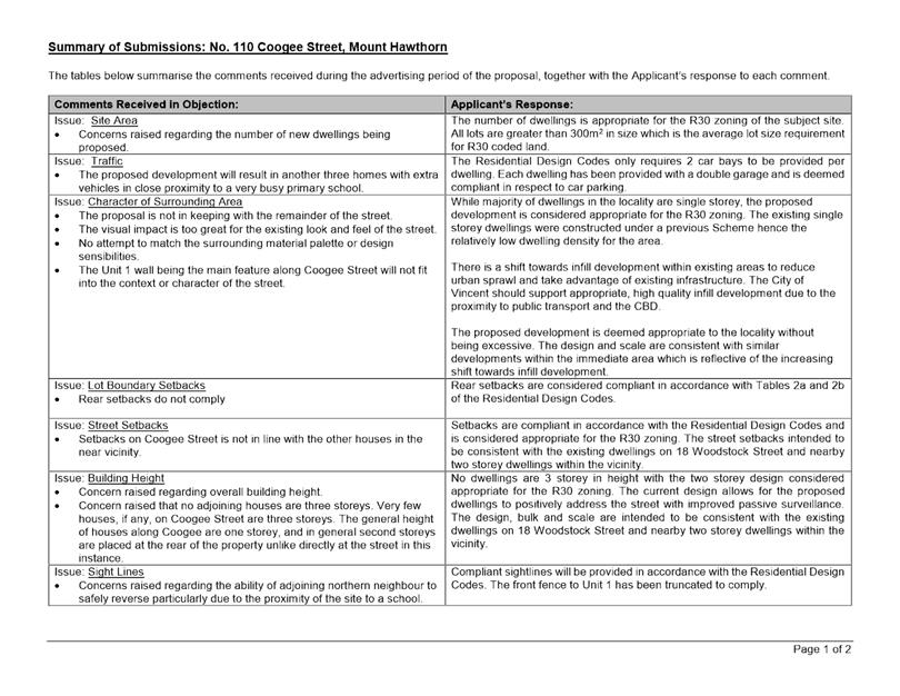
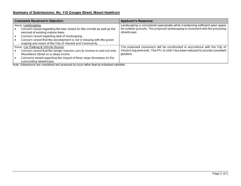
The City received seven submissions at the conclusion of the first round of consultation. All seven submissions received objected to the proposal. The main issues raised related to the following:
· The density, bulk and scale of the proposed development;
· The impact of the proposed development on the existing character of the surrounding area; and
· The impact of increased vehicle access and car parking on the existing streetscape, including increased traffic generated by the proposal.
The City provided the applicant with a summary of the submissions received during the first round of consultation. The applicant responded by providing amended plans for the City’s consideration (included as Attachment 3). Modifications to the plans included the following:
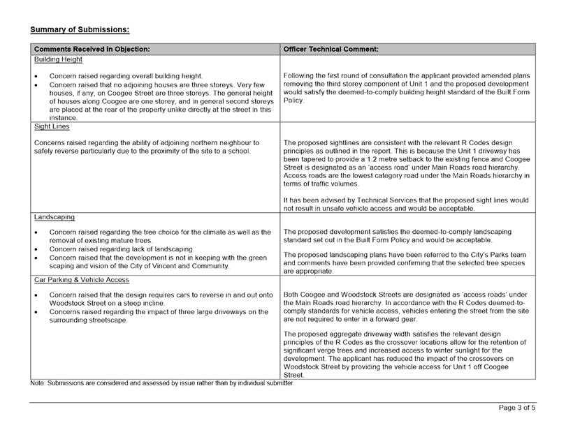
· Removing the third storey component of Unit 1;
· Changing the location of the Unit 1 driveway/crossover from Woodstock Street to Coogee Street to allow for the retention of the existing established street tree on the Woodstock Street verge;
· Lowering the finished floor level of Units 2 and 3 to satisfy the R Codes deemed-to-comply standards relating to site works and retaining walls; and
· Reducing the width of the driveways/crossovers.
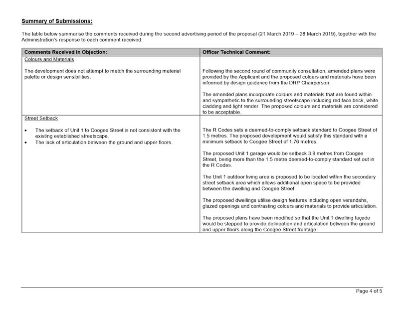
The amended plans were readvertised to the previous submitters for a period of seven days commencing on 21 March 2019 and concluding on 28 March 2019. The City received one further submission from a previous submitter in objection to the proposal. The objection that was received reiterated previous concerns, with emphasis on the following:
· The development not attempting to match the surrounding material palette or design sensibilities;
· The setback of Unit 1 to Coogee Street not being consistent with the existing established streetscape;
· The lack of articulation between the ground and upper floors; and
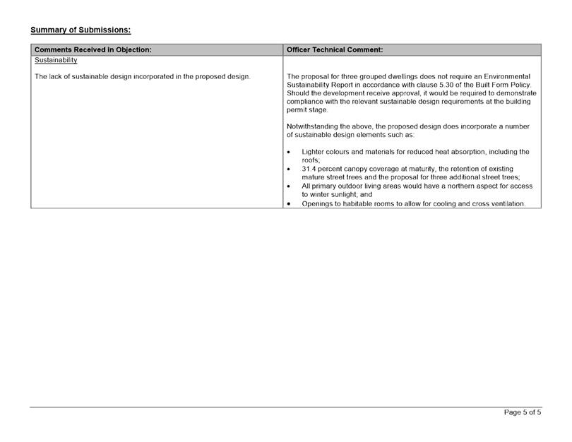
· The lack of sustainable design incorporated in the proposed design.
A summary of the submissions received during both rounds of advertising and Administration’s response is provided in Attachment 5. The applicant provided a response to the submissions received during the first round of advertising which is included in Attachment 6.
Design Review Panel (DRP):
Referred to DRP: Yes
During the two consultation periods concerns were raised that the proposed built form outcome would not be consistent with the existing and desired streetscape surrounding the subject site.
Administration sought the involvement of the DRP Chairperson following the conclusion of the second round of consultation. This is because it was considered that the proposal would benefit from such input and that it could facilitate an improved design outcome that would be more sympathetic to the surrounding streetscape.
Administration subsequently facilitated a meeting with the DRP Chairperson and the applicant in attendance. The plans that were discussed during this meeting are included as Attachment 3. The DRP Chairperson provided the following key comments and suggestions with respect to the proposal:
· Advised that the design may benefit from reducing the building bulk by providing additional open space between the street and the dwellings;
· Advised that darker colours and materials should be located at the ground floor level and lighter colours and materials at the upper floor level;
· Advised that the use of red face brick is consistent with the surrounding streetscape and could be incorporated into the front fence and planter beds rather than the grey render;
· Advised that the concealed roof elements of the proposed dwellings would not be consistent with the surrounding streetscape and should be reviewed; and
· Whilst the streetscape does include examples of more contemporary design, it is predominantly characterised by single storey dwellings with pitched and gable roofs, red face brick, light coloured render and whether boards.
The applicant subsequently prepared amended plans to incorporate the DRP Chairperson’s feedback. Modifications to the plans relate to the following:
· Increasing the Unit 1 garage setback to Coogee Street from 1.5 metres to 3.9 metres;
· Increasing the Unit 1 ground and upper floor setbacks to Coogee Street by changing the location of the outdoor living area;
· Changing the colours and materials of the street fencing, planter boxes and Unit 1 garage from grey render to red face brick;
· Increasing the Unit 1 upper floor setback to the northern lot boundary from 1.5 metres to 5.1 metres and providing a hip and gable roof above the ground floor garage;
· Changing the window configuration and styles to have vertical emphasis, being more reflective of the configuration and styles of existing dwellings’ windows in the streetscape;
· Removing the upper floor concealed roof design elements from the Unit 1 and Unit 3 dwellings in favour of pitched roof design elements;
· Changing the Unit 1 and Unit 3 verandah roof design from concealed to pitched with exposed rafters;
· Relocating the darker colours and materials from the upper floor facades to the ground floor facades;
· Changing the colour of the exterior render from grey to white; and
· Changing the roofs to a lighter colour.
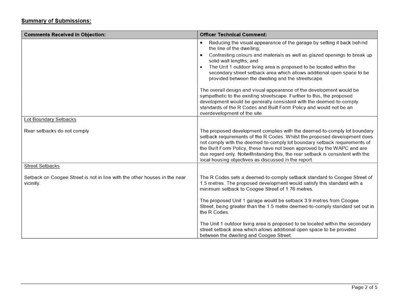
The modifications to the plans listed above have resulted in a design that would be sympathetic to the surrounding streetscape. With specific reference to the Coogee Street frontage, the proposed development incorporates design elements that would reduce the appearance of building bulk and allow for positive interaction with and surveillance of the streetscape. These design elements include:
· Articulation and stepping back of the building at the ground and upper floor levels;
· Contrasting colours and materials which would be complementary to the existing dwellings surrounding the subject site;
· Glazed openings with vertical emphasis;
· Delineation between the ground and upper floors; and
· Setbacks to the garage and dwelling which exceed the R Codes deemed-to-comply standards.
The proposed development would also be sympathetic to the Woodstock Street frontage. Woodstock Street does not demonstrate a high level of consistency in streetscape character as it serves as the secondary street for the majority of existing developments and is generally characterised by 1.8 metre high fences and building facades with minimal articulation and setbacks.
The amended plans submitted by the applicant following the meeting with the DRP Chairperson are included as Attachment 4 and the development proposal that the applicant is seeking approval for.
Legal/Policy:
· Planning and Development Act 2005;
· Planning and Development (Local Planning Schemes) Regulations 2015;
· City of Vincent Local Planning Scheme No. 2;
· State Planning Policy 3.1 – Residential Design Codes;
· Policy No. 4.1.5 – Community Consultation; and
· Policy No. 7.1.1 – Built Form Policy.
In accordance with Schedule 2, Clause 76(2) of the Planning and Development (Local Planning Schemes) Regulations 2015 and Part 14 of the Planning and Development Act 2005, the applicant would have the right to apply to the State Administrative Tribunal for a review of the Council’s determination.
Delegation to Determine Applications:
This matter is being referred to Council for determination as the proposal has received more than five objections during the City’s community consultation period.
Risk Management Implications:
There are minimal risks to Council and the City’s business function when Council exercises its discretionary power to determine a planning application.
Strategic Implications:
This is in keeping with the City’s Strategic Community Plan 2018-2028:
Innovative and Accountable
We are open and accountable to an engaged community
SUSTAINABILITY IMPLICATIONS:
Nil.
Financial/Budget Implications:
Nil.
Comments:
Lot Boundary Setback
The rear setbacks meet the deemed-to-comply setback standards of the R Codes. In addition to the deemed-to-comply requirements of the R Codes, the lot boundary setback provisions of Clause 5.3 of the Built Form Policy establish deemed-to-comply requirements that are intended to operatively replace the deemed-to-comply requirements of the R Codes. The deemed-to-comply lot boundary setback standards set out in the Built Form Policy have not yet been approved by the WAPC. As such, these provisions are given due regard in the assessment of the application.
The Built Form Policy sets a 6.5 metre rear lot boundary setback deemed-to-comply standard. The application proposes minimum rear setbacks of 5.1 metres for Unit 1, and 1.39 metres for Units 2 and 3.
In having due regard for the Built Form Policy, the proposed lot boundary setbacks satisfy the local housing objectives for the following reasons:
· The upper floor portions of Units 2 and 3 dwellings are setback 4.5 metres from the northern lot boundary, with the ground floor portions being setback 1.39 metres. These ground floor portions of Units 2 and 3 primarily consist of alfresco areas which are open style structures that do not result in excessive building bulk;
· The proposed dwelling façades orienting toward the northern lot boundary provide both articulation and glazing to effectively reduce the appearance of blank solid walls and associated building bulk on the adjoining properties;
· Due to the favourable orientation of the lots, the proposed dwellings would not have an adverse impact on the adjoining northern property’s access to direct sun; and
· The application meets the R Codes deemed-to-comply standards for visual privacy.
Open Space
The R Codes sets a deemed-to-comply standard of 45 percent open space for properties with an R30 density coding. Unit 2 proposes 43.5 percent open space.
The proposed open space for Unit 2 satisfy the design principles of the R Codes for the following reasons:
· The development meets with the R Codes deemed-to-comply standards for lot boundary setbacks as well as the Built Form Policy deemed-to-comply standard for street setback and would not result in excessive building bulk;
· The dwelling is setback appropriately from the northern lot boundary to allow for sufficient natural sunlight and ventilation;
· The development meets the Built Form Policy deemed-to-comply standards for landscaping through the provision of deep soil zones and mature tree canopy areas; and
· The proposed dwelling exceeds the R Codes deemed-to-comply standards for outdoor living areas and provides ample opportunity for occupants of the dwelling to undertake outdoor pursuits.
Sight Lines
The R Codes sets a deemed-to-comply sight line standard for driveways. This sets out that there should be no structures greater than 750 millimetres in height within a 1.5 metre by 1.5 metre truncation from the point where a driveway meets a street boundary. The application shows the retention of the existing 1.37 metre high fence along the northern lot boundary and that this will be within the 1.5 metre by 1.5 metre truncation area on the northern side of the proposed driveway for Unit 1.
The proposed sight lines for the Unit 1 driveway satisfy the design principles of the R Codes for the following reasons:
· The Unit 1 driveway has been tapered between the garage opening and the street boundary to provide a 1.2 metre setback to the existing fence. This provides sufficient vehicle sight lines and ensures safety and visibility along the footpath adjacent to the site;
· The proposed driveway provides vehicle access to and from Coogee Street which is designated as an ‘access road’ under Main Roads road hierarchy. Access roads are the lowest category road under the Main Roads hierarchy in terms of traffic volumes; and
· The crossover for the adjoining property to the north at No. 112 Coogee Street is setback 0.3 metres from the existing 1.37 metre high fence and has been since 2005.
· It has been advised by Technical Services that the proposed sight lines would not result in unsafe vehicle access and would be acceptable.
Outdoor Living Areas
The R Codes sets a deemed-to-comply standard for outdoor living areas to be provided behind the street setback line. Unit 1 proposes the outdoor living area within the secondary street setback area.
The proposed outdoor living area for Unit 1 satisfy the design principles of the R Codes for the following reasons:
· The outdoor living area would be capable of use in conjunction with the dining and family areas of the dwelling;
· The outdoor living area would be open to the northern aspect and associated winter sunlight whilst also providing covered areas for whether protection;
· The outdoor living area would have a total size of 41.5 square metres which is greater than the R Codes deemed-to-comply standard of 24 square metres for an R30 coded site;
· Whilst the primary outdoor living area would be within the secondary street setback area, Unit 1 also provides for a smaller private courtyard with a total size of 15.2 square metres screened from the street and accessible from the kitchen; and
· The outdoor living area would be separated from the street by a 1.8m high fence to provide privacy for occupants of the dwelling.
Vehicle Access
The R Codes sets a deemed-to-comply standard for vehicle access requiring that where available, vehicle access should be provided to the site from the ROW. The application proposes that vehicle access for Unit 3 be from Woodstock Street rather than the ROW.
The R Codes also sets a deemed-to-comply standard for aggregate driveway width of 9 metres at the street boundary for a single property. The application proposes an aggregate driveway width of 11.8 metres at the street boundary, with 7.4 metres aggregate width to Woodstock Street and 4.4 metres width to Coogee Street.
The proposed vehicle access for Unit 3 from the ROW and aggregate driveway width for the development satisfy the design principles of the R Codes for the following reasons:
· The subject site has a downward slope from east to west of approximately 2.5 metres along the Woodstock Street frontage. The highest portion of the site is located along the eastern lot boundary abutting the ROW. Vehicle access being provided from the ROW would otherwise require a greater amount of fill to be incorporated for the Unit 3 dwelling to enable this. The proposal to have vehicle access from Woodstock Street allows Unit 3 to better respond to the natural features of the site and would minimise the amount of excavation and fill on-site, resulting in a dwelling floor level that sits more appropriately with the slope of the site;
· Woodstock Street is identified as an ‘access road’ which is the lowest category road under the Main Roads road hierarchy. The R Codes permits vehicle access from access roads and the proposed vehicle access for Unit 3 from Woodstock Street would not result in an unsafe access arrangement to and from the site;
· Whilst the development in its entirety proposes an aggregate driveway width of 11.8 metres, it does not propose more than 9 metres of driveway width from any single street frontage. The application would result in an aggregate driveway width on the Woodstock Street frontage of 7.4 metres which accounts for 17.8 percent of the 41.5 metre frontage which would not be excessive;
· The original proposal was reviewed the City’s Parks Team and it was advised that the location of the Unit 1 crossover from Woodstock Street was not supported as it would require the removal of an existing mature and established street tree. The modified proposal with the Unit 1 crossover from Coogee Street allows for the retention of all street trees along the Woodstock Street frontage. The modified proposal would result in the removal of a street tree on the Coogee Street frontage and this has been reviewed by Parks and Urban Green and it has been advised that this would be considered acceptable as this tree is a sapling and has been recently planted. Three additional trees to be planted in the verge of Woodstock Street are also being proposed as part of the application, indicating that the aggregate driveway widths are not excessive and that the development provides for significant verge planting;
· The proposed driveways are tapered from the garage openings to the street boundary. This would reduce the amount and impact of hard surface vehicle access points on the streetscape, and provide for more soft landscaping opportunity to be planted in the street verges;
· The proposed access points from Woodstock Street would not be out of character with the existing streetscape which includes a number of garages such as those at No. 18A Woodstock Street and No. 101 Flinders Street to the east of the subject site. These garages are setback 4 metres and 1 metre from the lot boundary respectively, being less than the 4.3 metres that is proposed by the current application; and
· The proposed vehicle access widths allows for the provision of deep soil areas and trees that will contribute to mature canopy coverage within the street setback areas. This would contribute positively to the streetscape and reduce the impact of vehicle access points;
Landscaping
In addition to the deemed-to-comply standards of the R Codes, the application has also been assessed against the landscaping provisions of the Built Form Policy that sets out additional deemed-to-comply standards. The deemed-to-comply landscaping standards set out in the Built Form Policy have not yet been approved by the WAPC and as such, these provisions are given due regard in the assessment of the application.
The Built Form Policy requires 15 percent of the site to be provided as deep soil zone and 30 percent of the site provided as canopy coverage at maturity. The application proposes 19 percent deep soil zone and 31.4 percent canopy coverage at maturity. In relation to landscaping:
· The application proposes trees within the rear setback area abutting the northern lot boundary which would soften the appearance of the development from the adjoining property;
· The application proposes trees within the street setback areas which would soften the appearance of the development from the street;
· Three additional street trees along the Woodstock Street frontage is being proposed to be installed;
· The proposed landscaping would provide increased amenity for the future occupants of the site and the surrounding area;
· The proposal would result in an overall increase in canopy across the site from what currently exists;
· The application proposes ground cover landscaping along the street boundaries in conjunction with the mature canopy coverage within the street setback areas; and
· The proposed landscaping does not negatively impact the use and activation of the ROW as it would not impede surveillance between Unit 3 and the ROW.
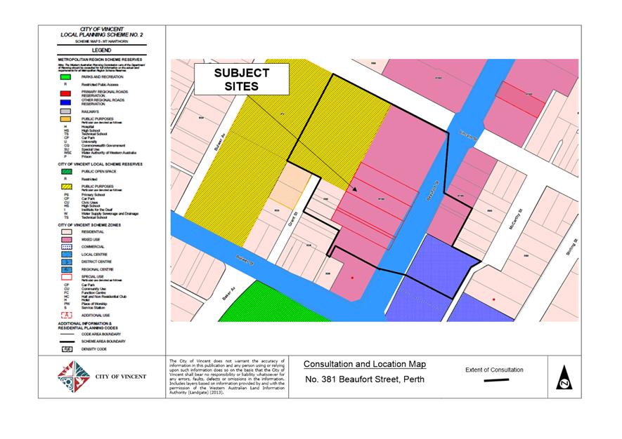
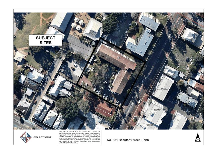
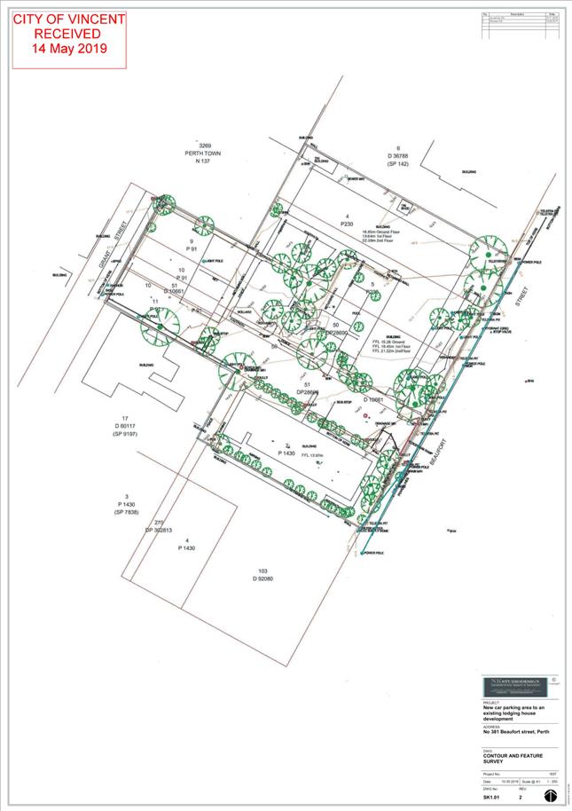
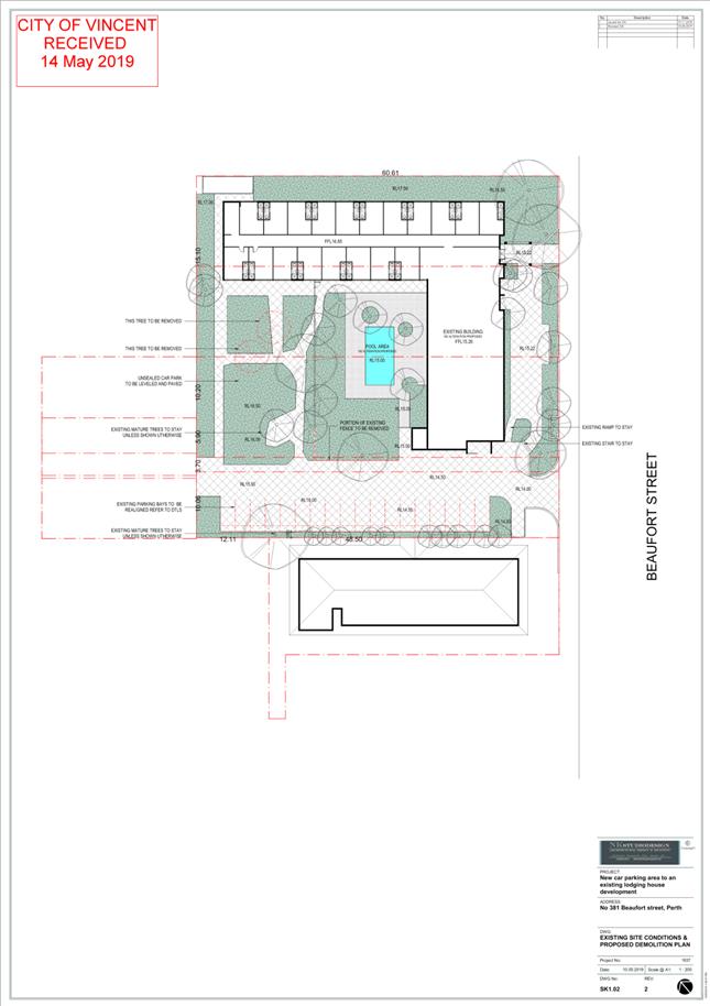
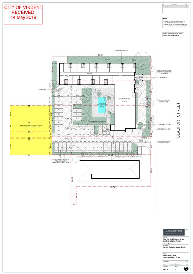
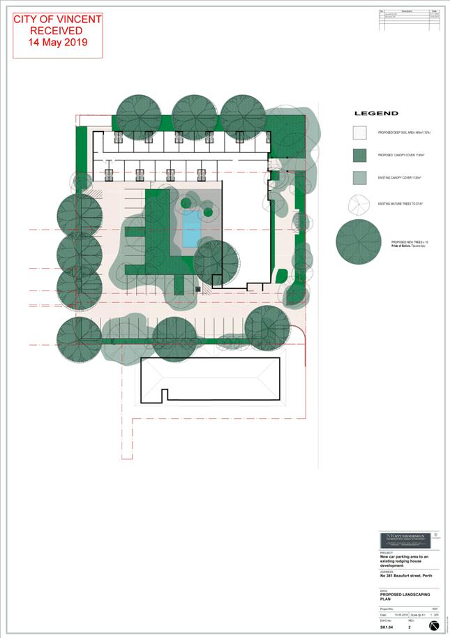
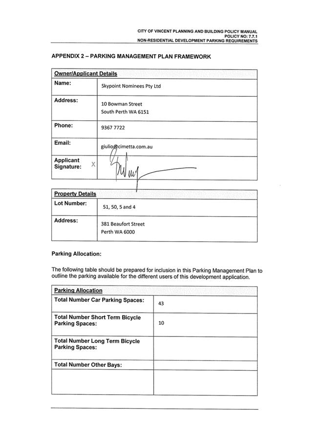
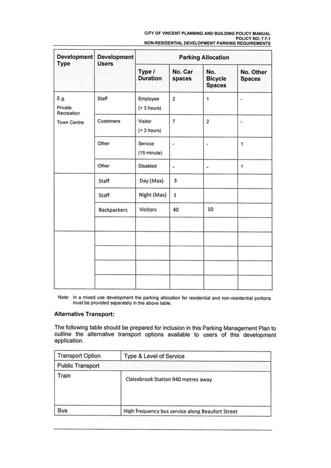
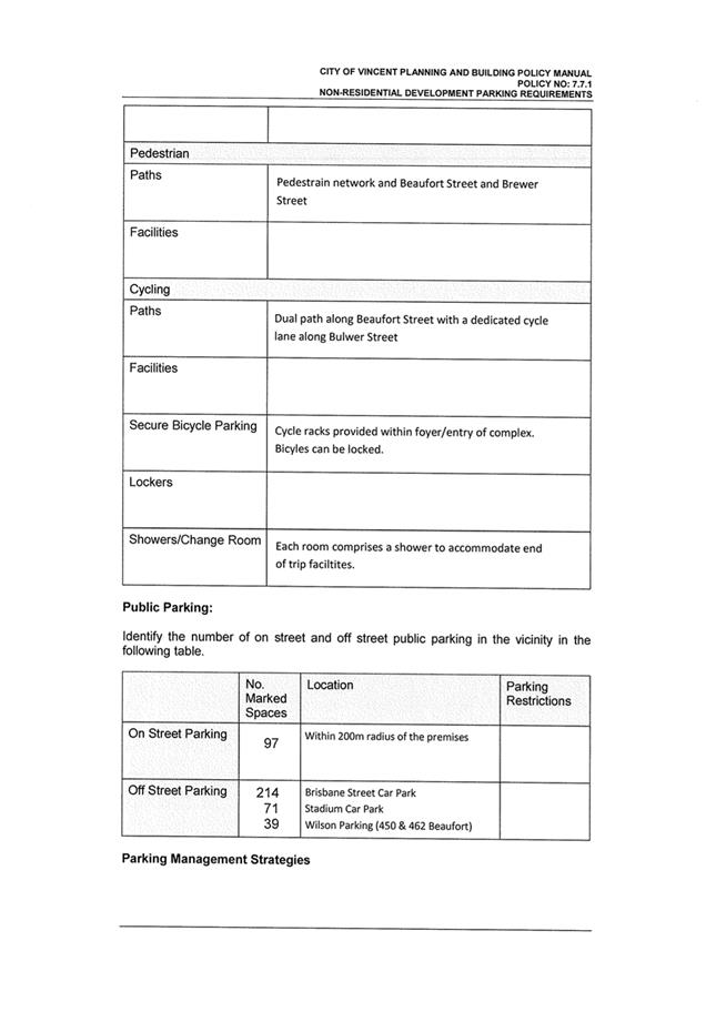
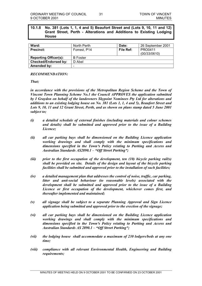
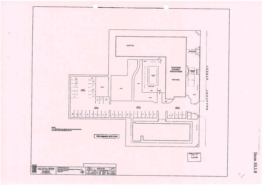
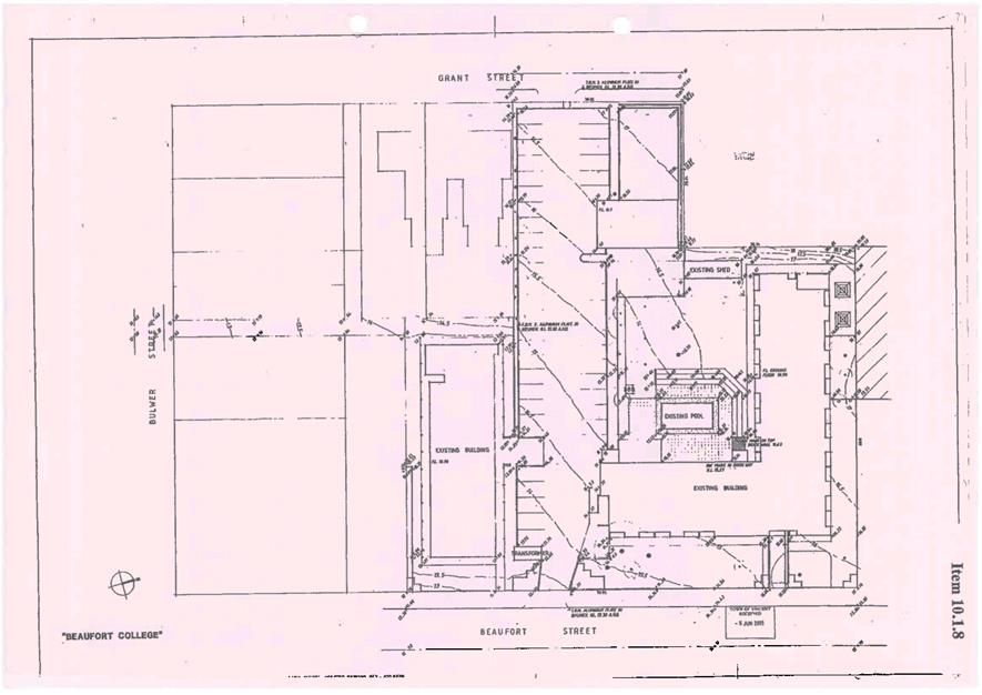
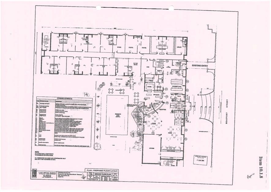
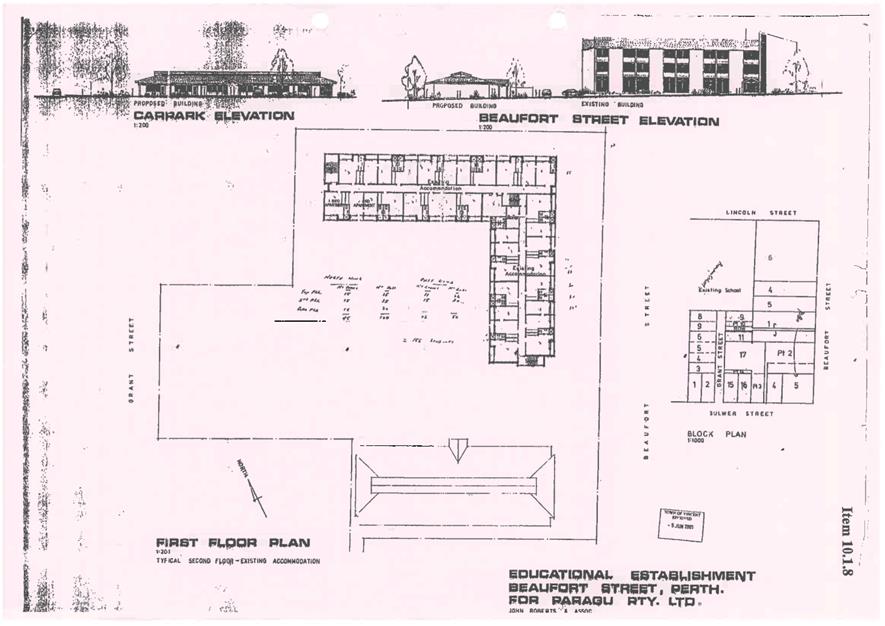
5.4 No. 381 (Lots: 50 and 51; D/P: 28690, Lots: 4 and 5; D/P: 230, Lot: 1; D/P: 1430) Beaufort Street, Perth - Car Park Addition to Lodging House
TRIM Ref: D19/91770
Author: Karsen Reynolds, Urban Planner
Authoriser: Joslin Colli, Coordinator Planning Services
Ward: South
Attachments: 1. Consultation
and Location Map ⇩ ![]()
2. Development Plans
⇩ ![]()
3. Supporting
Information ⇩ ![]()
4. Minutes of 9
October 2001 Council Meeting and Approved Development Plans ⇩ ![]()
5. Summary of
Submissions - Adminstration's Response ⇩ ![]()
6. Determination
Advice Notes ⇩ ![]()
|
That Council, in accordance with the provisions of the City of Vincent Local Planning Scheme No. 2 and the Metropolitan Region Scheme, APPROVES the application for Car Park Addition to Lodging House at No. 381 (Lots: 50 and 51; D/P: 28690, Lots: 4 and 5; D/P: 230, and Lot: 1; D/P: 1430) Beaufort Street, Perth, in accordance with plans provided in Attachment 2, subject to the following conditions, with the associated determination advice notes in Attachment 6: 1. This approval relates to the car parking and landscaping shown on the approved plans dated 14 May 2019. No other development forms part of this approval; 2. Amalgamation Within 90 days of this development approval Lots: 50 and 51; D/P: 28690 and Lots: 4 and 5; D/P: 230, (‘The lots’) are to be amalgamated into a single lot on a Certificate of Title. The owner shall be responsible to pay all costs associated with the City’s solicitor’s costs incidental to the preparation of (including all drafts) and stamping of the agreement and lodgement of the absolute caveat; 3. Parking and Access 3.1 A minimum of 43 onsite parking bays shall be provided in accordance with the approved plans within 60 days of development approval, to the satisfaction of the City. The parking bays are not to be used for storage purposes or the like; 3.2 The car parking and access areas shall be sealed, drained, paved and line marked in accordance with the approved plans and are to comply with the requirements of AS2890.1, within 60 days of development approval, to the satisfaction of the City; and 3.3 A minimum of 10 bicycle facilities shall be provided and designed in accordance with AS2890.3, within 60 days of development approval, to the satisfaction of the City; 4. Landscaping Plan All landscape works shall be undertaken in accordance with the approved plans to the City’s satisfaction, within 60 days of development approval, and maintained thereafter to the satisfaction of the City at the expense of the owners/occupiers; and 5. All other aspects of the approved plans and all conditions and advice notes included in planning approval 00.33.0610, granted on 9 October 2001, continue to apply to this approval. |
Purpose of Report:
To consider an application for development approval for a Car Park Addition to the existing Lodging House at No. 381 Beaufort Street, Perth (subject site).
PROPOSAL:
The subject site is located at No. 381 Beaufort Street, Perth, as shown on the location plan included as Attachment 1.
The application proposes to replace the existing car park previously used by the lodging house located on Lots 9, 10 and 11 Grant Street, Perth. The car park is proposed to be relocated on Lots 4, 5, 50 and 51 Beaufort Street, Perth (the subject site). Details of the proposal are as follows:
· Provision of 43 on-site parking bays across Lots 5, 50 and 51 Beaufort Street, Perth. This includes one ACROD bay;
· In addition to the 43 on-site bays, one turning bay has been provided to allow vehicles to exit the street in forward gear if all parking bays are full;
· In addition to the 43 on-site bays, one service bay has been provided;
· Provision of 10 bicycle parking bays;
· Provision of additional landscaping including mature trees;
· Provision of a 1.5 metre landscaping strip along the perimeter of the car parking area; and
· The proposal does not seek to modify the existing approved lodging numbers, rooms or any other aspect of the existing built form.
The development plans of the proposal are included as Attachment 2. Supporting information provided by the applicant are included in Attachment 3.
Background:
|
Landowner: |
Skypoint Nominees Pty Ltd |
|
Applicant: |
CF Town Planning and Development |
|
Date of Application: |
11 March 2019 |
|
Zoning: |
MRS: Urban LPS2: Zone: Mixed Use R Code: R100 |
|
Built Form Area: |
Activity Corridor |
|
Existing Land Use: |
Lodging House |
|
Proposed Use Class: |
Lodging House |
|
Lot Area: |
3664m² |
|
Right of Way (ROW): |
No |
|
Heritage List: |
No |
The subject site is legally described as No. 381 Beaufort Street, Perth, which comprises of five separate lots (being Lots 1, 4, 5, 50 and 51) with a combined area of 3664 square metres. A parcel of land owned by the Water Corporation forms part of the subject site (known as Lot 1 on Deposited Plan 1430). The Water Corporation have signed the relevant form and provided written consent to the application and use of the land for car parking. The property at No.381 (Lot 2) Beaufort Street, Perth situated to the south of the subject land is a separate commercial property with its own parking arrangements, this site does not form part of the proposal.
The subject site is zoned Mixed Use R100 under the City of Vincent Local Planning Scheme No. 2 (LPS2). The subject site is bound by Beaufort Street to the east, existing multiple dwellings to the north, Highgate Primary School to the north-west, existing single house developments to the south-west, and a commercial property to the south. Beaufort Street is reserved as an Other Regional Road (ORR) under the Metropolitan Region Scheme, a portion of which affects the eastern boundary of the subject site. The land along Beaufort Street, to the north and south of the subject site, is zoned Mixed Use R100 under LPS2. The land to the east and south-east of the subject site is zoned Residential R80.
At its Ordinary Meeting of Council held on 9 October 2001, Council resolved to grant approval to various additions and alterations to the existing lodging house at the subject site. The Minutes of the 9 October 2001 Ordinary Council Meeting and approved development plans are included as Attachment 4. As part of the decision, Council imposed a condition of approval that the lodging house should accommodate a maximum of 230 lodgers/beds at any one time within the approved 60 bedrooms. The application was also approved with 43 on-site car bays, this involved approval of a 33.6 shortfall to the parking requirements at that time.
The application included adjoining Lots 9, 10 and 11 Grant Street, Perth. The lots on Grant Street were used as the primary car parking area for the lodging house, accommodating 25 on-site bays. The remaining 18 on-site bays were provided on Lot 51 Beaufort Street, Perth. In December 2018 the landowners of the subject site disposed of the lots fronting Grant Street, Perth (Lots 9, 10 and 11). The sale of land and removal of the parking bays has resulted in a shortfall of 25 on-site parking bays and is a departure from the City’s approval granted on 9 October 2001.
Following compliance investigation, the applicant submitted a development application seeking approval for the car park replacement. A development application is required as the proposal is an amendment to an existing non-conforming use.
The subject lots are owned by a number of people and sit on a multi lot title. Creation of an individual title and sale of any of the lots can occur at any time by landowner request to Landgate, with no required consultation with the Local Government. Administration has recommended a condition of approval requiring the Amalgamation of Lots 4, 5, 50 and 51 onto one Certificate of Title, to safeguard a similar situation from occurring in the future.
Plans for the proposal are included in Attachment 2. The supporting information provided by the applicant is included in Attachment 3, including written justification, the applicant’s response to neighbour submissions received during the consultation period, and a parking management plan.
Details:
Summary Assessment
The table below summarises the planning assessment of the proposal against the provisions of the City of Vincent Local Planning Scheme No. 2 (LPS2), the City’s Policy No. 7.1.1 – Built Form and Policy No. 7.7.1– Non-Residential Development Parking Requirements. In each instance where the proposal requires the discretion of Council, the relevant planning element is discussed in the Detailed Assessment section following from this table.
|
Planning Element |
Use Permissibility/ Deemed-to-Comply |
Previously approved |
|
Land Use |
|
ü |
|
Landscaping |
ü |
|
|
Parking & Access |
|
ü |
|
Bicycle Facilities |
ü |
|
Consultation/Advertising:
Community consultation was undertaken in accordance with the Planning and Development (Local Planning Schemes) Regulations 2015 for a period of 21 days from 15 April 2019 to 6 May 2019. The method of consultation included a sign being placed on site, a notice being placed in the local newspaper and 229 letters being mailed to all the owners and occupiers of the properties adjoining the subject site, as shown in Attachment 1.
During the community consultation, the City received a total of two submissions, both objecting to the proposal. A summary of submissions and Administration’s response is provided in Attachment 5. The Applicants response to the summary of submissions is included in Attachment 3.
Department of Planning, Lands and Heritage (DPLH)
The application was referred to the DPLH for its advice as the development is adjacent to Highgate Primary School, which is a State Heritage Registered Place. The Heritage Council advised that it has no objection to the proposal.
Referral to DPLH was not required in relation to the ORR as the development value is less than $20,000.00 and as the proposal is an incidental addition that does not have the intention to alter the existing access arrangements.
Design Review Panel (DRP):
Referred to DRP: No
The development application was not referred to the DRP for comment as the proposal does not result in any changes to the built form.
Legal/Policy:
· Planning and Development Act 2005;
· Planning and Development (Local Planning Schemes) Regulations 2015;
· City of Vincent Local Planning Scheme No. 2;
· Policy No. 4.1.5 – Community Consultation;
· Policy No. 7.1.1 – Built Form Policy; and
· Policy No. 7.7.1 – Non-Residential Development Parking Requirements.
Should Council refuse the application for development approval, the applicant would have the right to have the decision reviewed in accordance with Part 14 of the Planning and Development Act 2005.
Delegation to Determine Applications:
This matter has been referred to Council in accordance with the City’s Delegated Authority Register as the original development application was determined by Council.
Risk Management Implications:
There are minimal risks to Council and the City’s business function when Council exercises its discretionary power to determine a planning application.
Strategic Implications:
This is in keeping with the City’s Strategic Community Plan 2018-2028:
Innovative and Accountable
We are open and accountable to an engaged community.
SUSTAINABILITY IMPLICATIONS:
Nil.
Financial/Budget Implications:
Nil.
Comments:
Parking
At its Ordinary Meeting of Council held on 9 October 2001, Council resolved to grant approval for additions and alterations to the existing lodging house at the subject site. Council approved the development application with 43 on-site parking bays. The sale of adjoining lots formerly part of the subject site facing Grant Street resulted in the loss of 25 onsite parking bays.
The subject development application seeks approval for 25 additional car parking bays which combined with the 18 existing on site bays provides the required 43 onsite parking bays in accordance with the 2001 development approval in compliance with AS2890.1.
The proposal also includes an additional 10 bicycle bays to be provided on site with associated private end of trip facilities. The development does not result in a further shortfall to the previously approved parking shortfall and is supported.
The design of the proposed parking arrangement is favourable in that it does not require any alterations to the existing built form and has retained the majority of the existing mature tree canopy cover on site. New trees have been provided to maximise shade to the open air car park, and along lot boundaries to provide privacy and increased amenity to adjoining properties.
5.5 No. 274 (Lot: 3; D/P: 2841) Bulwer Street, Perth - Proposed Change of Use from Shop House to Restaurant/Café (Unauthorised Existing Development)
TRIM Ref: D19/88179
Author: Karsen Reynolds, Urban Planner
Authoriser: Joslin Colli, Coordinator Planning Services
Ward: South
Attachments: 1. Consultation
and Location Map ⇩ ![]()
2. Development Plans
⇩ ![]()
3. Supporting
Information ⇩ ![]()
4. Summary of
Submissions - Administration's Response ⇩ ![]()
5. Department of
Planning, Lands and Heritage Comments ⇩ ![]()
6. Determination
Advice Notes ⇩ ![]()
|
That Council, in accordance with the provisions of the City of Vincent Local Planning Scheme No. 2 and the Metropolitan Region Scheme, APPROVES the application for the Change of Use from Shop House to Restaurant/Café (Unauthorised Existing Development) at No. 274 (Lot: 3; D/P: 2841) Bulwer Street, Perth, in accordance with plans provided in Attachment 2, subject to the following conditions, with the associated determination advice notes in Attachment 6: 1. Use of Premises 1.1 This approval relates to a Change of Use from Shop House to Restaurant/Cafe (unauthorised existing development) as shown on the plans dated 10 May 2019 and 11 June 2019. It does not relate to any other development on the site; 1.2 The development shall be used in accordance with the definition of ‘Restaurant/Cafe’ as set out in the City’s Local Planning Scheme No. 2; 1.3 The total number of persons attending the Restaurant/Cafe at any one time, including staff and customers, shall be limited to 40 persons; and 1.4 The operating hours of the Restaurant/Cafe shall be limited to 7:00am to 9:00pm Monday to Sunday, including public holidays; 2. Acoustic Report 2.1 An Acoustic Report, in accordance with the City's Policy No. 7.5.21 – Sound Attenuation and to the satisfaction of the City, shall be lodged with and approved by the City within 30 days of the development approval. All of the recommended measures included in the approved Acoustic Report shall be implemented as part of the development; and 2.2 Certification from an acoustic consultant shall be provided to the City that the recommended measures identified in the approved Acoustic Report have been undertaken to the City’s satisfaction, within 60 days of the development approval; 3. Building Design 3.1 All external fixtures and building plant, including air conditioning units, piping, ducting and water tanks, shall be located so as to minimise any visual and noise impact on surrounding landowners, and screened from view from the street, and where practicable from adjoining buildings, within 30 days of the development approval, to the satisfaction of the City; and
3.2 Windows and doors of the ground floor tenancies fronting Bulwer Street shall provide an active and interactive relationship to the street and shall be maintained thereafter to the satisfaction of the City. Blinds, roller shutters and other screening and shielding devise shall remain open during the operating hours; 4. Parking and Access 4.1 A minimum of 4 off-street parking bays shall be provided for staff use. The parking bays are not to be used for storage purposes or the like; 4.2 The car parking and access areas shall be sealed, drained, paved and marked as ‘staff only’ in accordance with the approved plans and are to comply with the requirements of AS2890.1, within 30 days of the development approval, to the satisfaction of the City; and 4.3 A minimum of 4 bicycle facilities shall be provided and designed in accordance with AS2890.3, within 30 days of the development approval, to the satisfaction of the City; 5. Signage The signage shown on the approved plans dated 10 May 2019 shall be kept in a good state or repair, safe, non-climbable and free from graffiti for the duration of its display onsite. |
Purpose of Report:
To consider an application for unauthorised existing development for a change of use from Shop House to Restaurant/Café at No. 274 Bulwer Street, Perth (subject site).
PROPOSAL:
The application proposes to change the use of the subject site from a Shop House to a Restaurant/Café. The subject site has been operating as a Restaurant/Café without development approval from the City since March 2019. The applicant submitted a development application seeking approval for a Restaurant/Café in order to obtain a Section 40 certificate (to form part of application for liquor license). The applicant paid a fee that is three times that of a standard application fee that encompasses the processing fee of the development application and a penalty for commencing development without prior approval, as provided by the Planning and Development (Local Planning Schemes) Regulations 2015.
The Restaurant/Café would operate Monday to Sunday from 7:00am – 9:00pm. A maximum of 34 customers and six staff members are proposed to be on site at any one time. External works proposed involve advertising signs only.
Background:
|
Landowner: |
Giovanni Di Placido |
|
Applicant: |
Rodney Suric |
|
Date of Application: |
8 February 2019 |
|
Zoning: |
MRS: Urban LPS2: Zone: Residential R Code: R50 |
|
Built Form Area: |
Residential |
|
Existing Land Use: |
Shop House |
|
Proposed Use Class: |
Restaurant/Café |
|
Lot Area: |
260.84m² |
|
Right of Way (ROW): |
No |
|
Heritage List: |
No |
The subject site is zoned Residential R50 under the City of Vincent Local Planning Scheme No. 2 (LPS2). The building was approved by the City of Perth as a Shop House in 1961. The City has no record of any further approvals since the 1961 development approval.
The subject site is bound by Bulwer Street to the south-east, Palmerston Street to the north-east and existing Single House developments to the north and west of the subject site. Bulwer Street is reserved as an Other Regional Road (ORR) under the Metropolitan Region Scheme, a portion of which affects the south-eastern corner of the subject site. A location plan is included in Attachment 1. The proposed advertising signage is located within the portion of the subject site affected by the Bulwer Street ORR reservation. The land surrounding the subject site is zoned Residential R50 under LPS2 and consists generally of single and two storey residential development. Adjacent land to the south of the subject site is zoned Mixed Use R40 and has been approved as a Motel and Restaurant/Café.
A previous Café business, ‘Le Papillon’ operated from the subject site without development approval from circa 2000 to July 2018. The new Restaurant/Café business is proposed to operate as ‘Boo Too'. The new business proposes to extend the operating hours and increase the dining room floor area to that utilised by the previous Café business. The City has not received any formal complaints regarding amenity impacts associated with the previous or current Restaurant/Café business.
Plans for the proposal are included in Attachment 2. The supporting information provided by the applicant is included in Attachment 3, including a management plan, acoustic justification and a parking management plan.
Details:
Summary Assessment
The table below summarises the planning assessment of the proposal against the provisions of the City of Vincent Local Planning Scheme No. 2 (LPS2), the City’s Policy No. 7.1.1 – Built Form and Policy No.7.7.1 – Non- Residential Development Parking Requirements. In each instance where the proposal requires the discretion of Council, the relevant planning element is discussed in the Detailed Assessment section following from this table.
|
Planning Element |
Use Permissibility/ Deemed-to-Comply |
Requires the Discretion of Council |
|
Land Use |
|
ü |
|
Car Parking |
|
ü |
|
Bicycle Parking |
|
ü |
|
Advertising Signs |
|
ü |
|
Hours of Operation |
ü |
|
|
Sound Attenuation |
|
ü |
Detailed Assessment
The deemed-to-comply assessment of the element that requires the discretion of Council is as follows:
|
Land Use |
|
|
Deemed-to-Comply Standard |
Proposal |
|
Local Planning Scheme No. 2
“P” Use |
“A” Use |
|
Car Parking |
|
|
Deemed-to-Comply Standard |
Proposal |
|
Policy No. 7.7.1 – Non-Residential Development Parking Requirements
Car Bays
0.25 car parking bays per person 10 car bays (based on 40 persons on site)
|
Car Bays
4 bays available on-site |
|
Bicycle Bays
Short Term: 1 bicycle bay (0.76)
Long Term: 2 bicycle bays (1.7) |
Bicycle Bays
Short Term: Nil
Long Term: 3 bicycle bays |
|
Advertising Signs |
|
|
Deemed-to-Comply Standard |
Proposal |
|
Policy No. 7.5.2 – Signs and Advertising
Two signs permitted |
Three signs proposed |
|
Sound Attenuation |
|
|
Deemed-to-Comply Standard |
Proposal |
|
Policy No. 7.5.21 – Sound Attenuation
Acoustic report required for non-residential uses in residential zones |
Acoustic report not provided |
The above elements of the proposal do not meet the specified deemed-to-comply standards and are discussed in the comments section below.
Consultation/Advertising:
Community consultation was undertaken in accordance with the Planning and Development (Local Planning Schemes) Regulations 2015 for a period of 27 days from 3 April 2019 to 30 April 2019. An additional six business days were provided to the 21 day consultation period due to the Easter and Anzac Day public holidays. The method of consultation included a sign being placed on site, a notice being placed in the local newspaper and eight letters being mailed to all the owners and occupiers of the properties adjoining the subject site, as shown in Attachment 1.
During the community consultation, the City received a total of six submissions; one objecting to the proposal; four submissions in support of the proposal; and one submission that neither supported nor objected to the proposal. The submission received in objection raised the following concerns:
· Concerns the proposal would be utilised as a live music venue;
· Pedestrian access;
· Car parking; and
· Hours of operation.
A summary of submissions and Administration’s response is provided in Attachment 4. The applicant sought to respond to neighbour submissions through an amended management plan and parking management plan provided in Attachment 3.
Department of Planning, Lands and Heritage
The application was referred to the Department of Planning, Lands and Heritage (DPLH) as the development abuts and is affected by Bulwer Street which is reserved as an ORR under the MRS. the DPLH advised that it has no objection to the proposal. Comments received from DPLH are included in Attachment 5.
Design Review Panel (DRP):
Referred to DRP: No
The application did not require referral to the DRP given there is no external works proposed, except for advertising signs.
Legal/Policy:
· Planning and Development Act 2005;
· Planning and Development (Local Planning Schemes) Regulations 2015;
· City of Vincent Local Planning Scheme No. 2;
· Policy No. 4.1.5 – Community Consultation;
· Policy No. 7.5.2 – Signs and Advertising;
· Policy No. 7.5.21 – Sound Attenuation; and
· Policy No. 7.7.1 – Non-Residential Development Parking Requirements.
Planning and Development Act 2005
Should Council refuse the application for development approval, the applicant may have the right to have the decision reviewed in accordance with Part 14 of the Planning and Development Act 2005.
LPS2
In considering the appropriateness of the use, Council shall have regard to the objectives of the Residential zone under LPS2, as follows:
· To provide for a range of housing and a choice of residential densities to meet the needs of the community.
· To facilitate and encourage high quality design, built form and streetscapes throughout residential areas.
· To provide for a range of non-residential uses, which are compatible with and complementary to residential development.
· To promote and encourage design that incorporates sustainability principles, including but not limited to solar passive design, energy efficiency, water conservation, waste management and recycling.
· To enhance the amenity and character of the residential neighbourhood by encouraging the retention of existing housing stock and ensuring new development is compatible within these established areas.
· To manage residential development in a way that recognises the needs of innovative design and contemporary lifestyles.
· To ensure the provision of a wide range of different types of residential accommodation, including affordable, social and special needs, to meet the diverse needs of the community.
Delegation to Determine Applications:
The matter is being referred to Council in accordance with the City’s Delegated Authority Register. The application for development approval proposes a shortfall of more than five car parking bays under the minimum parking requirements of Local Planning Policy No. 7.7.1 – Non-Residential Development Parking Requirements (Non-Residential Parking Policy). The application also seeks Council’s discretion to waive cash-in-lieu requirements for the proposed shortfall of car parking bays.
Risk Management Implications:
There are minimal risks to Council and the City’s business function when Council exercises its discretionary power to determine a planning application.
Strategic Implications:
This is in keeping with the City’s Strategic Community Plan 2018-2028:
Innovative and Accountable
We are open and accountable to an engaged community.
SUSTAINABILITY IMPLICATIONS:
Nil.
Financial/Budget Implications:
Nil.
Comments:
Land Use
Within the Residential zone, a Restaurant/Café is an ‘A’ use, which requires advertising to be undertaken before discretion being exercised. In considering the appropriateness of the use regard is to be given to the objectives of the Residential zone under LPS2.
The City did not receive specific community submissions relating to the permissibility of the Restaurant/Café use. The proposal is consistent with the objectives of the Residential zone under LPS as follows:
· The development re-uses an existing building on-site with minor modifications and upgrades proposed. The adaptive re-use of an existing building is considered to be consistent with sustainability principles;
· The application proposes no alterations to the existing façade of the building, except for an updated paint colour and advertising signage, ensuring that the development would maintain the existing streetscape character and amenity of Bulwer Street. The ground floor design provides for a pedestrian awning with an open and active façade provided to encourage pedestrian activity;
· The adjoining properties to the south and south-east (across Bulwer Street) are both commercial in nature and the Restaurant/Café use would not encroach on these uses due to the separation that Bulwer Street provides;
· The residential property to the north-east of the subject site is well separated from the dining area of the proposed Restaurant/Café. The adjoining residential properties to the east of the subject site (across Palmerston Street) are well separated from the subject site. The separation distance between the subject site and the nearby residential and commercial properties is considered sufficient to mitigate the occurrence of any conflicts between the commercial and residential land uses;
· The residential property to the west of the subject site at No. 276 Bulwer Street Perth is under the same ownership of the Restaurant/Café and thus provides no objection to the proposal;
· The applicant has provided a Parking Management Plan to demonstrate that parking can be appropriately managed. Administration has also recommended that a condition of approval is provided requiring an Acoustic Report to be submitted by the applicant that confirms the operations of the Restaurant/Café complies with the requirements of the Environmental Noise Regulations 1997. This would confirm that the proposed use is capable of operating from the subject site without generating nuisances detrimental to the amenity of the nearby properties or wider locality; and
· The subject site has long been associated with a commercial use and the City has no record of receiving any complaints relating to the operations of the previous or current Restaurant/Café use. This demonstrates that the Restaurant/Café is compatible with the surrounding residential development.
Car Parking
In accordance with the City’s Policy No. 7.7.1 – Non-Residential Parking Policy (Policy No. 7.7.1), a Restaurant/Café use is required to provide 0.25 car bays per person accommodated on-site. This results in a requirement of 10 car bays for the Restaurant/Café use based on the proposed maximum capacity of 34 patrons and 6 employees. The proposal provides a total of 4 car bays on site, resulting in a shortfall of 6 car bays. The on-site car bays are for staff use only.
During the consultation period, a submission was received objecting to the proposal. The objection raised concerns in regards to the provision of car parking and the impact the car parking shortfall would have on the availability of on-street parking.
A Parking Management Plan has been prepared and submitted by the applicant as justification for the proposed parking shortfall. This is included as Attachment 3 and outlines the following:
· There is a number of on-street car parking bays located within walking distance of the subject site. An occupancy survey was undertaken by the applicant that determined that at no time were 100 percent of on-street bays occupied while the current Restaurant/Café was operating;
· The subject site is in close walking distance to Hyde Park. The proposal allows for multi-purpose trips for people visiting Hyde Park;
· Four long-term bicycle spaces are provided on the site, with these available for use by staff. Six bicycle spaces also exist on the footpath directly in front of the Restaurant/Café, with these available for use by staff, guests and customers of the Restaurant/Café; and
· The subject site is within proximity of high frequency and regular frequency bus routes, as well as pedestrian paths connecting to local amenities. Bulwer Street includes a bicycle lane in both directions which connects to Palmerston Street, Vincent Street and Lord Street. Connection is also provided to the wider bicycle network including along Beaufort Street and Fitzgerald Street.
The proposed parking provision is suitable for the following reasons:
· The subject site is in close proximity to high amenity areas, including approximately 400 metres from the Northbridge activity precinct and 600 metres from the North Perth activity precinct;
· Within the immediate vicinity of the subject site (450 metres), there are 113 bays along Bulwer Street between Randall Lane and Lake Street and 78 bays along Palmerston Street between Glendower Street and Newcastle Street available for public parking. With respect to the parking provided along Palmerston Street, the City’s parking data indicates that there is on average 18 bays available. With respect to the parking along Bulwer Street, this has not been captured by the City’s parking data, a review of the City’s GIS mapping indicated that there is on average 72 bays available, with details of the demand as follows:
- Thursday 2 May 2019 – 41 cars parked;
- Sunday 24 February 2019 – 42 cars parked;
- Saturday 22 December 2018 – 36 bays parked;
- Sunday 28 October 2018 – 43 cars parked;
- Sunday 23 September 2018 – 40 cars parked;
- Wednesday 25 April 2018 – 53 cars parked; and
- Monday 12 February 2018 – 30 cars parked.
Based on the above, there is generally 90 on-street parking bays available for use within 450 metres of the subject site, and this is capable of accommodating parking for customers of the Restaurant/Café.
Noting the above, sufficient on-site parking is provided for staff of the development. There is sufficient alternative transport methods and public parking within the vicinity of the subject site to accommodate any customer parking demand, without the need for a cash-in-lieu contribution from the applicant.
Bicycle Parking
The development is required to provide one short-term bicycle bay and three long-term bicycle bays for the proposed capacity of 40 persons on site. The development provides four long-term bicycle bays at the rear of the site, accessible to staff. The development does not provide any short-term bicycle facilities within the site boundary. While there are no short term bicycle bays provided on the subject site, there is an existing City of Vincent bicycle rack located on the Bulwer Street verge adjacent to the subject site that can accommodate six short-term bicycles. The provision of long-term bays to the rear of the site and short-term bays that exist on the Bulwer Street verge ensure that there is sufficient bicycle spaces provided on site for the use of both customers and staff.
Signage
The City’s Policy No. 7.5.2 – Signs and Advertising (Signs and Advertising Policy) permits a maximum of two awning signs per tenancy. The development applicant proposes three awning signs, with one sign proposed to each awning elevation. Plans have been provided for two elevations and a photo image has been provided for the north-west elevation. The dimensions of the awning sign to the north-west elevation are the same as the dimensions of the south-east elevations.
The City did not receive specific community submissions relating to the proposed advertising signage. The proposal is consistent with the objectives of the Signs and Advertising Policy as follows:
· The signage provided meets the permitted dimensions as prescribed in the Policy No. 7.5.2;
· The scale and design of the signage is appropriate to the building and the architectural detailing to which it relates. The additional signage does not result in a proliferation of signage;
· The third sign is a result of the premises being located on a corner site. With only one sign proposed per elevation, the signage does not dominate the streetscape; and
· The scale and design of the signage is compatible with the existing surrounding development and the size and colours of the sign are appropriate with the area.
Noting the above, the proposal ensures that the signage does not adversely impact the amenity of the surrounding properties, while providing appropriate exposure of the proposed use.
Acoustic Report
The City’s Policy No. 7.5.21 – Sound Attenuation requires development applications for non-residential uses located in residential zones to be accompanied by an acoustic report. The applicant has not provided an acoustic report prepared by an Acoustic Consultant/Engineer, and has instead provided written justification addressing management of noise generated on site, which is included in Attachment 3 and outlines the following:
· The adjoining properties to the south and south-east (across Bulwer Street) are both commercial in nature and the Restaurant/Café use would not encroach on these uses in terms of noise due to Bulwer Street providing a buffer between the sites. The south-east property has a large communal pool and amenities area that also faces onto the street and would generate noise;
· The residential property to the west of the subject site at No. 276 Bulwer Street Perth is under the same ownership of the Restaurant/Café and provides no objection to the proposal;
· The City has not received any formal complaints relating to noise from the previous and current Restaurant/Café use; and
· The use is required to comply with the Environmental Protection (Noise) Regulations 1997 at all times. This safeguards the requirement to comply with the assigned levels at all times.
Following a review of the applicants written justification, Administration recommends an acoustic report be prepared and submitted to the City by an Acoustic Consultant / Engineer. The new business proposes to extend the operating hours and increase the dining room floor area to that utilised by the previous Café business. While the proposal is expected to comply with the Environmental Protection (Noise) Regulations 1997, for the reasons detailed in the applicant’s justification, appropriate acoustic measures would ensure that this occurs. In light of this, a condition is recommended for an acoustic report to be provided to ensure that the proposed use is capable of operating from the subject site without generating nuisances detrimental to the amenity of the nearby properties or wider locality.
If the application is approved by Council the City’s Compliance Services team would follow up compliance with this condition to ensure it is met within a reasonable period and that the recommendations as provided within the acoustic report are implemented.
TRIM Ref: D19/88875
Author: Clair Morrison, Urban Planner
Authoriser: Jay Naidoo, Manager Development & Design
Ward: South
Attachments: 1. Consultation
and Location Plan ⇩ ![]()
2. Development Plans
⇩ ![]()
3. Written
Submission and Technical Reports ⇩ ![]()
4. Summary of
Submissions - Administration's Response ⇩ ![]()
5. Design Review
Panel Meeting 8 May 2019 Minutes and Applicant's Response ⇩ ![]()
6. Determination
Advice Notes ⇩ ![]()
|
That Council in accordance with the provisions of the City of Vincent Local Planning Scheme No. 2 and the Metropolitan Region Scheme, APPROVES the application for development approval for six Multiple Dwellings and Home Office at No. 66 (Lot: 1; D/P: 5285) Lindsay Street, Perth, in accordance with the plans shown in Attachment 2 subject to the following conditions, with the associated advice notes in Attachment 6: 1. Use of Premises 1.1 The use of the room on the ground level associated with Apartment 1 indicated as ‘Home Office’ of the approved plans shall only be used in accordance with the definition of Home Office within the City of Vincent Local Planning Scheme No. 2 as follows: Home Office means a dwelling used by an occupier of the dwelling to carry out a home occupation if the carrying out of the occupation – (a) is solely within the dwelling; and (b) does not entail clients or customers travelling to and from the dwelling; and (c) does not involve the display of a sign on the premises; and (d) does not require any change to the external appearance of the dwelling; and 1.2 The 20 square metre room on the ground floor indicated as ‘Home Office’ shall be used as a communal space for activities associated with the Multiple Dwellings and for the exclusive use of residents that does not entail clients or customers travelling to and from the site; 2. Car Parking, Access and Bicycle Facilities 2.1 A minimum of 12 parking bays for the residents of the Multiple Dwellings shall be provided on the site, with a minimum of two car parking bays allocated to each Multiple Dwelling; 2.2 All walls, letterboxes or fences above 0.75 metres in height to be constructed within 1.5 metres of where the vehicle access point adjoins the public street, as indicated on the approved plans dated 11 June 2019, are to be visually permeable in accordance with the definition of State Planning Policy 7.3 Residential Design Codes, unless otherwise approved by the City; 2.3 Vehicle and pedestrian access points shall match into existing footpath levels to the satisfaction of the City; 2.4 The car park shall be used only by owners and visitors directly associated with the development; 2.5 The approved sliding gate and security infill panels to the car parking area shall be visually permeable in accordance with the definition of Visually Permeable in the State Planning Policy 7.3: Residential Design Codes Volume 2 – Apartments; 2.6 Prior to the first occupation of the development, the car parking spaces provided for the residential component of the development shall be clearly marked and sign posted for the exclusive use of the residents of the development and shall not be in a tandem arrangement unless they service the same residential unit/dwelling; 2.7 The applicant shall agree in writing to provide a notice on any Sales Contract to advise prospective purchasers that the City of Vincent will not issue a residential or visitor car parking permit to any owner or occupier of the residential dwellings; and 2.8 Bicycle Parking A minimum of one short-term bicycle bay shall be provided for where possible within the development. The bicycle bay shall be designed in accordance with AS2890.3 and installed prior to occupation to the satisfaction of the City; or Should there be no suitable location for a short-term bicycle facility to be available on-site, a cash-in-lieu contribution of $400 shall be paid to the City for the shortfall of one short-term bicycle bay, based on the cost of $400 per Class 3 bicycle parking facility, prior to the occupation of development; 3. Access Management Plan 3.1 Prior to occupation of the development an Access Management Plan shall be submitted to and approved by the City. The access management plan is to include the following: · Detailed management measures for the operation of the vehicular entry gate, to ensure access is readily available for owners/visitors/tenants to the residential units at all times; and 3.2 The Plan as identified in Condition 3.1 above shall be implemented and shall be maintained thereafter to the satisfaction of the City at the expense of the owners/occupiers; 4. Boundary Walls The owners of the subject land shall finish and maintain the surface of the boundary wall facing No. 255 Beaufort Street, No. 247 Beaufort Street and No. 243 Beaufort Street, in a good and clean condition prior to the practical completion of the development and thereafter maintained to the satisfaction of the City; 5. Visual Privacy 5.1 Privacy screening to a height of 1.6 metres above the finished floor level as indicated on the approved plans. All privacy screening shall be visually impermeable and is to comply with the Acceptable Outcomes of the State Planning Policy 7.3: Residential Design Codes Volume 2 – Apartments, to the satisfaction of the City; and 5.2 All screening is to be shown on the plans at the time of lodging a building permit and must be installed prior to occupation of the development; 6. Building Design 6.1 Doors and windows and adjacent floor areas fronting Lindsay Street shall provide an active and interactive relationship to the street to the satisfaction of the City and shall be maintained thereafter to the satisfaction of the City; 6.2 Ground floor glazing and/or tinting shall be a minimum of 70 percent visually permeable to provide unobstructed visibility. Darkened, obscured, mirrored or tinted glass or other similar materials as considered by the City is prohibited; and 6.3 The awning within the Lindsay Street road reservation attached to the façade of the building shall be designed to be removable, to the satisfaction of the City; 7. Schedule of External Finishes Prior to the commencement of development, a detailed schedule of external finishes (including materials, colour schemes and details) shall be submitted to and approved by the City. The development shall be finished in accordance with the approved schedule prior to the use or occupation of the development; 8. External Fixtures All external fixtures, such as television antennas (of a non-standard type), radio and other antennas, satellite dishes, solar panels, external hot water heaters, air conditioners, and the like, shall not be visible from the street(s), are designed integrally with the building, and be located so as not to be visually obstructive; 9. Clothes Drying Facilities Each multiple dwelling shall be provided with a clothes drying area screened from the public realm in accordance with State Planning Policy 7.3: Residential Design Codes Volume 2 – Apartments, to the satisfaction of the City, prior to the occupation or use of the development; 10. Landscaping 10.1 An updated detailed landscape and reticulation plan for the development site and adjoining road verge, to the satisfaction of the City, shall be lodged with and approved by the City prior to lodgement of a Building Permit. The plan shall be drawn to a maximum scale of 1:200 and show the following: · The location and type of existing and proposed trees and plants, and on-structure planting; · Areas to be irrigated or reticulated; · The provision of 7.8 percent deep soil area as defined by State Planning Policy 7.3 Residential Design Codes: Volume 2 – Apartments; · The provision of two medium size trees, in accordance with the Acceptable Outcomes of Element 3.3 Tree Canopy and Deep Soil Areas of State Planning Policy 7.3 Residential Design Codes Volume 2 – Apartments, contributing towards 11.7 percent canopy coverage within deep soil zones provided and within the side and rear setback areas. The tree species are to be in accordance with the City’s recommended tree species list; and · Provision of at least two trees, with a planting size of at least 200 litres, within the verge of Lindsay Street adjoining the development shall be provided at the full expense of the landowner. The tree species is to be approved by the City prior to the occupation of the development; 10.2 All works shown in the approved plans as identified in condition 10.1 above shall be undertaken in accordance with the approved plans to the City’s satisfaction, prior to the occupancy or use of the development and maintained thereafter to the satisfaction of the City at the expense of the owners/occupiers; 11. Acoustic Report and Noise Management Prior to the lodgement of a Building Permit, a revised Acoustic Report in accordance with the City's Policy No. 7.5.21 – Sound Attenuation shall be lodged with and approved by the City. All of the recommended measures included in the revised Acoustic Report shall be implemented to the satisfaction of the City prior to the occupation or use of the development and shall be maintained thereafter to the satisfaction of the City at the expense of the owners/occupiers. The engagement and implementation of the recommendations by the acoustic consultant are to be at the applicant’s expense; 12. Waste Management 12.1 A Waste Management Plan prepared to the satisfaction of the City shall be submitted and approved by the City; and 12.2 Waste management for the development shall thereafter comply with the approved Waste Management Plan; 13. Construction Management Plan A Construction Management Plan that details how the construction of the development will be managed to minimise the impact on the surrounding area shall be lodged with and approved by the City prior to the commencement of the development. The Construction Management Plan is required to address the following concerns that relate to any works to take place on the site: · Public safety, amenity and site security; · Contact details of essential site personnel; · Construction operating hours; · Noise control and vibration management; · Dilapidation Reports of nearby properties; · Air, sand and dust management; · Stormwater and sediment control; · Soil excavation method; · Waste management and materials re-use; · Traffic and access management; · Parking arrangements for contractors and subcontractors; and · Consultation plan with nearby properties; and 14. Stormwater All stormwater produced on the subject land shall be retained on site, by suitable means to the full satisfaction of the City. |
Purpose of Report:
To consider an application for development approval for a six Multiple Dwellings at No. 66 Lindsay Street, Perth (the subject site).
PROPOSAL:
The application proposes the development of a four storey development on the subject site. The proposal consists of:
· Six multiple dwellings, one two-bedroom dwelling and five three-bedroom dwellings;
· One home office located on the ground level;
· Communal open space located on level three; and
· Vehicle access provided from Lindsay Street and 12 car parking bays.
The proposed development plans are included as Attachment 2. The associated written submissions and technical reports are included as Attachment 3.
Background:
|
Landowner: |
Charlotte Fehr |
|
Applicant: |
Campion Design Group |
|
Date of Application: |
29 March 2019 |
|
Zoning: |
MRS: Urban LPS2: Zone: Mixed Use R Code: R80 |
|
Built Form Area: |
Mixed Use |
|
Existing Land Use: |
Vacant |
|
Proposed Use Class: |
‘P’ |
|
Lot Area: |
493m² |
|
Right of Way (ROW): |
No |
|
Heritage List: |
No |
The subject site is bound by car parking to the north and south, Lindsay Street to the west and a two-storey commercial development to the east. The location plan is included in Attachment 1. The subject site is currently vacant.
The subject site is zoned Mixed Use with a residential density of R80 under the City of Vincent Local Planning Scheme No. 2 (LPS2) and is located within the Mixed Use Built Form Area in accordance with City Policy No. 7.1.1 – Built Form (Built Form Policy). The adjoining lots to the south are also zoned Mixed Use and located within the Mixed Use Built Form Area. The adjoining lots to the north, east and west are zoned Commercial. The adjoining lots to the north and east are located within the Activity Corridor Built Form area. The adjoining lots to the west are located within the Mixed Use Built Form area.
Lindsay Street is characterised by single storey and two storey single dwellings. The immediately adjoining sites to the north and south are open air car parking facilities appurtenant to grouped dwellings and commercial development. A number of character homes located along Lindsay Street operate as offices. The subject site is adjacent to Beaufort Street which is characterised by two- to four-storey mixed use and commercial development.
Details:
Summary Assessment
The proposal was assessed in accordance with the requirements of the Built Form Policy and State Planning Policy 7.3 Residential Design Codes (R Codes – Volume 2) which relates to multiple dwelling developments. The R Codes Volume 2 provides guidance for the development mixed use development and focuses on improved design outcomes for apartments that are responsive and appropriate to the context and character of the site and locality. This is a performance-based assessment and applicants are required to demonstrate that the design achieves the objectives of each design element as well as the overall objectives of the R Codes Volume 2.
Consideration of Element Objectives and Acceptable Outcomes
The R Codes Volume 2 includes Element Objectives and Acceptable Outcomes for each design element. Proposals are required to demonstrate that the design achieves the Element Objectives for each design element. While addressing the Acceptable Outcomes is likely to achieve the relevant Element Objectives, they are not a deemed-to-comply pathway and the proposal is still to be assessed against the relevant Element Objectives. Where Acceptable Outcomes are not met, proposals may still satisfy the Element Objective via alternative means or solutions.
The Element Objectives and/or Acceptable Outcomes that are not achieved in the proposal are as follows:
|
Building Height |
|
|
Acceptable Outcome |
Proposal |
|
Built Form Policy Clause 3.1 Building Height
C 3.1.1 Maximum Building Height Top of External Wall (Concealed Roof): 14.3 metres Top of Skillion Roof: 14.3 metres Bottom of Skillion Roof: 13.3 metres |
Top of External Wall (Concealed Roof): 14.55 metres Top of Skillion Roof: 14.32 metres Bottom of Skillion Roof: 13.85 metres |
|
Street Setback |
|
|
Acceptable Outcome |
Proposal |
|
Built Form Policy Clause 1.2 Setbacks
A 1.2.1 Primary and secondary street setbacks nil for first three storeys.
There is no deemed-to-comply standard for floors above three storeys. |
Street setback for level two: nil to 3.8m
Street setback for level three: nil to 9m |
|
Lot Boundary Setbacks |
|
|
Element Objective |
Proposal |
|
R Codes Volume 2 – Clause 2.4 Side and Rear Setbacks
O 2.4.2 Building boundary setbacks are consistent with the existing streetscape pattern or the desired streetscape character. |
The subject site is located within an area of transition, with a mix of character homes and higher density mixed use development.
Council is being asked to consider whether the side and rear boundary setbacks are consistent with the desired streetscape character of Lindsay Street. |
|
Acceptable Outcome |
Proposal |
|
R Codes Volume 2 – Clause 2.4 Side and Rear Setbacks
A 2.4.1 For levels two and three a minimum setback of 4m is prescribed to all lot boundaries |
Southern (Side) Lot Boundary Setback Level two: Nil to 4.05m Level three: Nil to 4.05m
Northern (Side) Lot Boundary Setback Level two: Nil to 3.47m Level three: 1.52m to 3.5m
Eastern (Rear) Lot Boundary Setback Level two: Nil to 6.17m Level three: 3.0m to 5.85m |
|
Plot Ratio |
|
|
Acceptable Outcome |
Proposal |
|
R Codes Volume 2 – Clause 2.5 Plot Ratio
A 2.5.1 1.0 (493m²) |
1.63 (807.1m²) |
|
Tree Canopy and Deep Soil Areas |
|
|
Acceptable Outcome |
Proposal |
|
R Codes Volume 2 – Clause 3.3 Tree Canopy and Deep Soil Areas
A 3.3.4 10% deep soil areas (48.3m²) |
7.8% deep soil areas (37.8 m²) |
|
Visual Privacy |
|
|
Acceptable Outcome |
Proposal |
|
R Codes Volume 2 – Clause 3.4 Visual Privacy
A 3.4.1 Unenclosed private outdoor spaces to be set back 6m from adjoining R coded lots |
Level two balcony Front balcony to Apartment 5 setback 2.4m from southern adjoining lot
Level three balcony Front balcony to Apartment 6 setback 4m from southern adjoining lot |
|
Public Domain Interface |
|
|
Acceptable Outcome |
Proposal |
|
Built Form Policy Clause 1.4 Ground Floor Design
A1.4.12 Ceiling height to be minimum of 3.5m
A1.4.13 Ground floor space width between 7.5m to 9m |
Ceiling height proposed 2.9m
Ground floor spaces 6.7m and 4.9m wide |
|
Vehicle Access |
|
|
Acceptable Outcome |
Proposal |
|
R Codes Volume 2 – Clause 3.8 Vehicle Access
A3.8.7 Walls, fences and other structures truncated or reduced to no higher than 0.75 metres within 1.5 metres of where walls, fences, other structures adjoin vehicle access points where a driveway meets a public street and where two streets intersect. |
A structure taller than 0.75 metres located within 1.5 metres where the driveway meets the footpath in the public realm. |
|
Car and Bicycle Parking |
|
|
Element Objective |
Proposal |
|
R Codes Volume 2 – Clause 3.9 Car and Bicycle Parking
O3.9.1 Parking and facilities are provided for cyclists and other modes of transport |
There are no end-of-trip facilities proposed, or short-term bicycle bays for visitors. |
|
Acceptable Outcome |
Proposal |
|
R Codes Volume 2 – Clause 3.9 Car and Bicycle Parking
A3.9.1 Bicycle bays Visitor: 1 required
A 3.9.2 Car parking bays Visitor: 2 required |
Nil visitor bicycle bays
Nil visitor car bays |
|
Natural Ventilation |
|
|
Acceptable Outcome |
Proposal |
|
R Codes Volume 2 – Clause 4.2 Natural Ventilation
A 4.2.1 Habitable rooms have openings on at least two walls with a straight line distance between the centre of the openings of at least 2.1m |
Apartment Three Distance between openings in Bed 2: 1.3m
Apartment Four Distance between openings in Bed 1: 1.6m |
|
Size and Layout of Dwellings |
|
|
Acceptable Outcome |
Proposal |
|
R Codes Volume 2 – Clause 4.3 Size and Layout of Dwellings
A 4.3.2 Minimum dimension of living rooms: 4 metres
A4.3.4 The length of single aspect open plan living is no more than 9m in length |
Apartment Five Minimum dimension of living room: 3.5 metres
Apartment One Open plan living more than 9 metres in length
Apartment Two Open plan living more than 9 metres in length |
|
Façade Design |
|
|
Acceptable Outcome |
Proposal |
|
Built Form Policy Clause 1.5 Awnings, Verandahs and Collonades
C 1.5.1 Awnings minimum height of 3.5 metres from finished floor level of the underside of the awning.
C1.5.2 Development to provide continuous awning |
Minimum height of awning 2.8 metres from underside of the awning
Awning located above pedestrian entrance |
An assessment of how the proposal meets the Element Objectives of the R Codes Volume 2 – Apartments is discussed in the comments section below.
Consultation/Advertising:
Community consultation was undertaken in accordance with the Planning and Development (Local Planning Schemes) Regulations 2015 for a period of 21 days from 27 April 2019 to 17 May 2019. The method of consultation being a sign on site, an advertisement in the local newspaper, and 432 letters mailed out to all landowners and occupiers surrounding the site in accordance with the City’s Policy No. 4.1.5 – Community Consultation. The extent of consultation is outlined in Attachment 1.
The City received four submissions during the consultation period, two supporting the application and two objecting to the proposal. The main concerns raised in the submissions relate to the following matters:
· The height of the buildings in relation to the existing streetscape;
· The amount of overshadowing as a result of the building height;
· The setback of the development does not reflect the existing street setbacks and contributing to overlooking of neighbouring lots;
· Lack of visual privacy onto the neighbouring properties; and
· The character does not reflect the existing streetscape.
A summary of the submission received and Administration’s comments with respect to these is provided in Attachment 4.The applicant responded to the submissions made via amended plans.
Design Review Panel (DRP):
Referred to DRP: Yes
The proposal was presented to the DRP prior to formal lodgement. The Applicant amended the design to reflect the concerns of DRP for formal lodgement of the development application. The proposal was again referred to the DRP on 8 May 2019. The applicant provided amended plans and written response and justification against the concerns raised by DRP. The minutes from the DRP meeting held 8 May 2019 along with the written response from the applicant are attached in Attachment 4. The plans were referred to the Chair of the DRP, who confirmed that the proposed amendments were a suitable design response to all comments made at the meeting held 8 May 2019.
Legal/Policy:
· Planning and Development Act 2005;
· Planning and Development (Local Planning Schemes) Regulations 2015;
· City of Vincent Local Planning Scheme No. 2;
· State Planning Policy 7.3 – Residential Design Codes Volume 2 – Apartments;
· Policy No. 4.1.5 – Community Consultation;
· Policy No. 7.1.1 – Built Form Policy;
· Policy No. 7.5.9 – Home Business, Home Occupation, Home Office and Home Store; and
· Policy No. 7.5.23 – Construction Management Plans.
Planning and Development Act 2005
Should Council refuse the application for development approval, the applicant may have the right to have the decision reviewed in accordance with Part 14 of the Planning and Development Act 2005.
State Planning Policy 7.3 Residential Design Codes – Volume 2 Apartments (R Codes Volume 2 - Apartments
The R Codes Volume 2 – Apartments provides comprehensive guidance for the development of multiple dwellings and mixed use development and focuses on improved design outcomes for apartments that are responsive and appropriate to the context and character of the site and locality. This is a performance based assessment and applicants are required to demonstrate that the design achieves the objectives of each design element as well as the overall objectives of the R Codes Volume 2 – Apartments.
Delegation to Determine Applications:
This matter is being referred to Council in accordance with the City’s Delegated Authority Register as the proposed development incorporates more than three dwellings.
Risk Management Implications:
There are minimal risks to Council and the City’s business function when Council exercises its discretionary power to determine a planning application.
Strategic Implications:
This is in keeping with the City’s Strategic Community Plan 2018-2028:
Innovative and Accountable
We are open and accountable to an engaged community.
SUSTAINABILITY IMPLICATIONS:
Nil.
Financial/Budget Implications:
Nil.
Comments:
Building Height
The proposed building height is four storeys, with a maximum height of a concealed roof of 14.55 metres, a maximum height to the top of the skillion roof of 14.32 metres and a maximum height to the bottom of the skillion roof of 13.85 metres.
The City received two submissions objecting to the height of the development, raising concern with its consistency with the existing streetscape of Lindsay Street and reduction of natural sunlight on the southern adjoining lot.
The proposed building height is consistent with the objectives of Element 2.2 Building Height of the R Codes Volume 2 – Apartments and the local housing objectives of the Built Form Policy for the following reasons:
· The upper floors of the building are stepped in so as to mitigate the perception and impact of building bulk and mass. The development incorporates wrap-around balconies and articulation on the upper floors, to reduce the amount of blank walls and material bulk when viewed from the street;
· The use of natural colours and elements, including facebrick and corten-like cladding reduces the overall impact of bulk and scale when viewed from the street. The use of a light grey and “off-white” of the render reduces the perception of bulk and scale when viewed from adjoining properties;
· The subject site slopes a total of 0.88 metres from the north to south of the site and the highest point of the development is located in the centre of the lot, and unseen from all lot boundaries;
· The communal open space does not have a roof structure and is located on level three, limiting the impact of building bulk on the adjoining lots;
· The southern adjoining lots that would be overshadowed as a result of the application are commercial uses and open car parks, which results in an acceptable amount of overshadowing onto adjoining residential properties;
· There is no direct overlooking onto residential lots with the adjoining lot being for the purpose of a car park. The proposed design, landscaping and location of windows limits the amount of potential overlooking onto surrounding residential lots to the south along Lindsay Street; and
· The City’s Built Form Policy has identified the subject site as a suitable location for development of four storeys.
Street Setback
The proposed street setback varies from a nil setback to 3.8 metres for level two, and nil to 9.0 metres for level three.
The City received two objections to the street setback, raising concerns that the development does not reflect the existing streetscape of Lindsay Street and can contribute to overlooking of surrounding residential lots.
The proposed street setback is consistent with the objectives of Element 2.3 Street Setbacks of the R Codes Volume 2 – Apartments and the local housing objectives of the Built Form Policy for the following reasons:
· The proposed design incorporates articulation, variety of materials and balconies fronting the street, which reduces the overall impact of building bulk when viewed from the street;
· The proposal has been designed to maximise the amount of natural sunlight and ventilation into the dwellings, and provides an appropriate amount of visual privacy for residents of the proposed development and onto surrounding residential properties;
· The proposed planting at street level and on-structure planting infrastructure, particularly on level one balcony, provides an adequate amount of landscaping to reduce the impact of building bulk when viewed from the street;
· The street setback provides an appropriate amount of private open space for residents and facilitates the provision of sufficiently sized communal open space to the rear of the property;
· The layout of the dwellings and inclusion of landscaping on private open space allows for passive surveillance onto the public realm, whilst maintaining visual privacy into habitable rooms of the proposed dwellings; and
· The design of the ground floor tenancies, vehicle access gates and pedestrian entry foyer provide a clear transition between the private and public realms, while maintaining passive surveillance onto the street.
Side and Rear Setbacks and Visual Privacy
The proposal incorporates a nil setback to the side and rear boundaries on the ground level. The proposal incorporates setbacks to level one of nil to 2.86 metres to the northern boundary, nil to 6.01 metres to the eastern boundary and nil to 4.05 metres to the southern boundary. The proposal incorporates setbacks to level two of nil to 3.47 metres to the northern boundary, nil to 6.17 metres to the eastern boundary and nil to 4.05 metres to the southern boundary. The proposal incorporates setbacks to level three of 1.52 metres to 3.5 metres to the northern boundary, 3.0 to 5.85 metres to the eastern boundary and nil to 4.05 metres to the southern boundary.
R Codes Volume 2 – Apartments require balconies to be set back from adjoining lots that have an allocated density coding. The adjoining northern, eastern and western lots do not have a density coding and are not subject to the provisions relating to Visual Privacy. The adjoining southern lot has a density coding, but there is no residential development within the cone of vision setback area. The proposed setbacks of balconies to the southern lot boundary of 2.4 metres on the levels two and 4.0 metres on level three, with landscape screening proposed.
The City received two submissions objecting to the side and rear setbacks, raising concerns that they are inconsistent with the existing streetscape. These submissions also raised concern in relation to the amount of overlooking onto residential properties along Lindsay Street.
The proposed side and rear setbacks and building separation is consistent with the objectives of Element 2.4 Side and Rear Setbacks and Element 3.5 Visual Privacy of the R Codes Volume 2 – Apartments and the local housing objectives of the Built Form Policy for the following reasons:
· The proposal incorporates design elements to reduce the building bulk, such as wrap around balconies, articulation, colours and materials that mitigate the perception of bulk;
· The building is stepped in, with balconies along the northern and southern facades, on-structure planting infrastructure and articulated so as to mitigate building bulk and mass, and provides a transition between the subject site and adjoining lower density residential development;
· The design maximises the amount of natural ventilation and sunlight into the dwellings and there is adequate separation between development on surrounding properties to allow for adequate ventilation and sunlight;
· On-structure planting, to mitigate the impact of building bulk when viewed from surrounding properties and provide alternative means of stormwater management;
· The orientation and design of balconies and major openings, and on-structure planting infrastructure minimises direct overlooking on neighbouring residential habitable spaces and outdoor living areas, with majority of balconies maximising the northern sun which overlooks the commercially zoned lot and larger planting structures being included to the southern lot boundary to minimise the ability to overlook the grouped dwellings to the south of the subject site.
The development proposes boundary walls for the third and fourth floor. The development plans indicate a profiled concrete finish to reduce the perception of building bulk and scale when viewed from the public realm and neighbouring residential properties. Administration recommends that a condition be applied requiring details of finishes to the boundary walls be approved by the City prior to commencement of development.
Plot Ratio
The development proposes a plot ratio of 1.63 (807.1 square metres). The proposed street setback is consistent with the objectives of Element 2.5 Plot Ratio of the R Codes Volume 2 – Apartments for the following reasons:
· The proposed design elements, including articulated design, stepping back of the external dwelling walls, varying colours and materials, extensive glazing and on-structure landscape infrastructure reduces the perception of building bulk and scale as a result of the proposed plot ratio;
· The proposal provides sufficient car parking to cater for the use of the development;
· It is noted that the immediately adjoining northern, eastern and western lots are permitted for a plot ratio of 2.0, and this site provides an appropriate transition between the residential character of Lindsay Street and Beaufort Street urban centre;
· The development is consistent with the prescribed building height of the subject site and generally consistent with the prescribed lot boundary setbacks, and the proposal incorporates an articulated design making use of materials and finishes existing in the streetscape.
Solar and Daylight Access, and Natural Ventilation
The proposed building depth and orientation is consistent with the objectives of Element 4.1 Solar and Daylight Access and Element 4.2 Natural Ventilation of the R Codes Volume 2 – Apartments and the local housing objectives of the Built Form Policy for the following reasons:
· The internal layout and design of the proposed dwellings optimises natural daylight access and natural cross-ventilation throughout the dwellings;
· The articulation of the development and location of windows maximises opportunity to gain natural sunlight and ventilation into dwellings;
· The layout of the development optimises the number of dwellings that receive winter sun into habitable rooms and private open spaces;
· The orientation of the development minimises overshadowing onto surrounding residential development, particularly onto habitable spaces, outdoor living areas and solar collectors; and
· The layout of apartments and location of operable openings on external walls allows for adequate cross‑ventilation throughout the dwellings.
Tree Canopy and Deep Soil Areas
The proposal incorporates two medium trees providing 11.7 percent canopy cover, 7.8 percent deep soil areas (37.8 square metres) and 35.6 percent (172 square metres) on-structure planting areas. The subject site is currently vacant and has no existing vegetation.
R Codes Volume 2 – Apartments defines deep soil areas as “soft landscape area on a lot with no impeding building structure or feature above or below, which supports growth of medium to large canopy trees and meets a stated minimum dimension. Used primarily for landscaping and open to the sky, deep soil areas exclude basement car parks, services, swimming pools, tennis courts and impervious surfaces including car parks, driveways and roof areas.”
The proposed landscaping is consistent with the objectives of Element 3.3 Tree Canopy and Deep Soil Areas and Element 4.12 Landscape Design of the R Codes Volume 2 – Apartments and the local housing objectives of the Built Form Policy for the following reasons:
· The application incorporates two medium trees and significant amount of on-structure planting, improving the landscape amenity from the pre-development condition;
· The on-structure planting infrastructure provides double the deep soil area requirement in accordance with the Acceptable Outcomes of Element 3.3 Tree Canopy and Deep Soil Areas of the R Codes Volume 2 – Apartments;
· The on-structure planning infrastructure provides sufficient space for healthy plant and tree growth due to the soil depth, soil volume provided and species selected;
· The landscape infrastructure enhances the streetscape amenity when viewed from the street and surrounding residential properties, and provides for visual appeal of private and communal open spaces and an attractive outlook from habitable rooms;
· The on-structure planting increases the visual amenity of the development and mitigates the overall impact of building bulk and scale when viewed from the adjacent residential lots, and contributes towards a sense of open space between buildings;
· The proposed species are suitable for the location, given the amount of sun exposure and site conditions, ensuring the capability of growing to maturity;
· The landscaping infrastructure is integrated into the design of the building, in relation to materiality and located in key functional areas to provide increased residential amenity for residents and visual amenity for surrounding residential properties;
· The proposed landscaping contributes to an integrated sustainable design, with the proposed roof garden and landscaping infrastructure for communal open space is to contribute to stormwater management and the collection and reuse of rainwater; and
· The overall landscape amenity would provide an effective contribution to the City’s green canopy, landscape amenity and reduce the impact of the urban heat island effect in the immediate locality.
The applicant has indicated that at least two verge trees shall be installed, at the expense of the applicant, in lieu of on-site canopy. Administration considers this an appropriate response to the limited on-site canopy. A standard condition shall be implemented to ensure the species and size of the tree be approved by the City prior to installation within the verge.
Size and Layout of Dwellings and Managing the Impact of Noise
The proposed dwellings provide adequate floor space in relation to the relevant acceptable outcomes. The applicant submitted an acoustic report as part of the application, which identifies the impact of noise on residents of the development. The proposed multiple dwellings are consistent with the objectives of Element 4.3 Size and Layout of Dwellings for the following reasons:
· The siting and layout of dwellings minimises the impact of external noise sources, from internal sources such as common spaces and circulation areas;
· The layout and size of dwellings provides spaces with access to natural sunlight and allows for adequate cross-ventilation;
· The size of habitable spaces allows for flexible spaces to accommodate furniture settings, internal storage and ample space to move between rooms; and
· The development proposes dwelling sizes that cater for diverse households and changing demographics, with the ability to provide homes for ageing community or family households.
The applicant submitted an Acoustic Report, which failed to demonstrate the ability to meet the objectives of Element 4.7 Managing the Impact of Noise or the provisions of the City’s Policy No. 7.5.21 – Sound Attenuation, given the acoustic report not adequately addressed the following, thereby drawing a number of unsupported conclusions:
· The use of ‘modelled sound levels’ for transport impact (not acceptable);
· Any demonstrated sound level recordings undertaken to support conclusions on what would or would not be received at the development;
· An absence of comment on surrounding land uses (namely a nightclub on Stirling Street) and how that would/would not impact development;
· An absence of comment on the proposed private car park (on private land, which is not exempt from compliance with the assigned levels of the Noise Regulations);
· No specific reference to mechanical device limitations or recommendation on suitable options.
Administration are satisfied that the acoustic requirements are capable of being achieved through a revised acoustic report prior to lodgement of a building permit application. A standard condition has been recommended to this effect.
Vehicle Access, and Car and Bicycle Parking
The subject site has sole vehicle access from Lindsay Street, with the development incorporating a single width crossover with a sliding, decorative gate fronting Lindsay Street. The proposed vehicle access arrangements are consistent with the objectives of Element 3.8 Vehicle Access of the R Codes Volume 2 – Apartments and local housing objectives of the Built Form Policy for the following reasons:
· The sliding gate presents as a cut-out decorative screen, which reduces the visual impact of the vehicle access point and car parking area on Lindsay Street;
· The sliding gate has the ability to ensure that the visual truncation area remains safe for pedestrians and vehicle users along Lindsay Street; and
· The vehicle and pedestrian access point are appropriately distanced apart to provide a safe environment for cyclists and pedestrians accessing the site.
The home office is considered suitable within the visual truncation area given:
· The gate opening would require the vehicle user to stop prior to existing the lot, providing adequate time to sight pedestrians;
· Lindsay Street is an Access Road, which does not exceed 3,000 vehicles per day;
· Visitors are not permitted to home office spaces, limiting the amount of pedestrian movement;
· The internal communal space is accessible from the internal car park, thereby not requiring weather protection;
· Each dwelling has twice the amount of required car parking bays with visitors expected to park in the internal car park, limiting the amount of pedestrian movement outside the development; and
· The surrounding land uses do not generate large number of pedestrian movement along Lindsay Street pedestrian network.
The proposed development provides two car parking bays for each multiple dwelling, resulting in a total of twelve car parking bays and no designated visitor bays. The applicant has indicated that visitor entry would be operable via each apartment. The details of this can be practically detailed closer to the occupancy of the development. The City’s Parking and Parking Facilities Local Law 2007 permits vehicles to stall on the street verge, unless explicitly prohibited by a sign, when authorised by an owner or occupier of the immediately adjoining lot, thereby permitting visitors to stall on the verge until the occupier permits entry. An Access Management Plan would be required to detail management measures for the operation of the access gate for visitors to the site.
The applicant provides one bicycle store, which can be considered long-term resident bicycle parking. A standard condition is recommended to ensure that a minimum of three long-term resident bicycle bays are provided within this bicycle store. The application does not incorporate short-term visitor bicycle bays. A standard condition is recommended for at least one class three bicycle facilities be installed to which would provide at least one short-term visitor bicycle bay, meeting the acceptable outcome. Should there be no location available on-site for a short-term facility that meet the requirements of AS2890.3 – bicycle parking, the City can accept a cash-in-lieu contribution to install one short-term bicycle facility within the public realm, immediately adjacent to the development. The bicycle store room is consistent with the objectives of Element 3.9 Car and Bicycle Parking of the R Codes Volume 2 – Apartments, given the subject site is located within a highly walkable pedestrian network, and close to employment centres on the outskirts of the Perth Central Business District (CBD) and the proposal does not maximise these facilities.
Environmentally Sustainable Design (ESD), Energy Efficiency and Water Management and Conservation
The applicant has provided an ESD report outlining the capability of the development to achieve at least a five-star rating under the Green Building Council of Australia’s Green Star rating system. The proposed dwellings are consistent with the objectives of Element 4.15 Energy Efficiency and Element 4.16 Water Management and Conservation of the R Codes Volume 2 – Apartments and local housing objectives of the Built Form Policy for the following reasons:
· The development incorporates construction elements and on-going management that are capable of achieving at least a five star rating under the Green Building Council of Australia’s Green Star rating system;
· The development demonstrates a reduction in greenhouse gas emissions, and propose solar energy sources to reduce non-renewable energy consumption;
· The extensive on-structure landscaping infrastructure provides on-site stormwater management for small scale rainfall events and assists in reducing the risk of flooding during major rainfall events; and
· Rainwater reuse is proposed to reduce minimise the use of potable water throughout the development.
Ground Floor Design
The ground floor incorporates one home office, 27 square metres and directly accessible from Apartment One and a 20 square metre internal communal space indicated as ‘Home Office’ accessible from the street and the internal car park. Pedestrian and vehicle access is from Lindsay Street, and the ground floor façade incorporates extensive glazing to provide passive surveillance and a variety of materials that reflect the existing streetscape character of Lindsay Street. The proposed ground floor design is consistent with the objectives of Element 3.6 Public Domain Interface of the R Codes Volume 2 – Apartments and local housing objectives of the Built Form Policy for the following reasons:
· The proposed vehicle access, through a permeable gate enhances the security of residents, whilst maintaining an attractive design;
· The home office, internal communal space and dwelling balconies provide passive surveillance to Lindsay Street, enhancing safety and security of pedestrians in the public domain;
· The proposed awning provides adequate shading and amenity to pedestrians using Lindsay Street, given:
o Visitors are not permitted to home office spaces, and are not expected to be attracted to the internal communal space; and
o The internal communal space is accessible from the internal car park, thereby not requiring weather protection;
· The ground floor tenancies integrate with the adjoining public spaces, through accessible entry ways and glazing of the proposed home office façade and internal communal space allowing uses to be clearly visible from the street; and
· The proposed façade design, explained in more detail below, provides an attractive, interesting design to contribute to the Lindsay Street streetscape.
The 20 square metre internal communal space indicated as ‘Home Office’ on the ground floor does not adequately fall into the definition of ‘home office’ as defined under LPS2, as it is not located solely within a proposed dwelling. This space is to be used as a communal space for the exclusive use and/or enjoyment of residents of the subject site. A condition is recommended to be imposed to ensure that this space is available for use for activities by residents of the subject site. This space is considered acceptable as the space is accessible from the internal car park, the space provides passive surveillance and interaction with the street and the space will not result in visitors to the subject site.
Waste Management
The proposed bin store is located within the car parking area of the development, and is capable of facilitating at least eight bins, broken down into four general waste and four recycling as required under the City’s Policy No. 2.2.11 – Waste Management. The layout and location is convenient for residents, and is adequately screened so as to not cause any adverse impact on the amenity of residents.
Through reviewing the proposal, the City’s Engineering Services have identified that further information is required to ensure that the on-going maintenance of bins and bin store area is capable of being undertaken. Should the application be approved a condition is recommended for a Waste Management Plan to be prepared by the applicant and approved by the City, ensuring that adequate waste management measures are implemented.
5.7 No. 123 (Lot: 14; D/P: 269) Claisebrook Road, Perth - Proposed Demolition of Entire Building and Like-for-Like Reconstruction of Existing Façade and Ground Floor Tenancy (Amendment to Approval)
TRIM Ref: D19/85444
Authors: Clair Morrison, Urban Planner
Mitchell Hoad, Senior Urban Planner
Authoriser: Jay Naidoo, Manager Development & Design
Ward: South
Attachments: 1. Consultation
and Location Map ⇩ ![]()
2. Original
Determination Minutes and Approved Plans ⇩ ![]()
3. Development Plans
⇩ ![]()
4. Written
Justification and Structural Engineering Report ⇩ ![]()
|
That Council, in accordance with the provisions of the City of Vincent Local Planning Scheme No. 2 and the Metropolitan Region Scheme, APPROVES the application for Demolition of Entire Building and Like-for-Like Reconstruction of Existing Façade and Ground Floor Tenancy (Amendment to Approval) at No. 123 (Lot: 14; D/P: 269) Claisebrook Road, Perth, in accordance with the plans shown in Attachment 3, subject to the following conditions: 1. All conditions, requirements and advice notes detailed on development approval 5.2017.31.1 granted on 20 December 2017 continue to apply to this approval with the exception of Condition 13.1 which is amended to read as follows: “13.1 Prior to commencement of development a detailed schedule of external finishes (including elevations demonstrating materials and colour schemes and details) shall be submitted to and approved by the City. The schedule is to demonstrate: 13.1.1 How the materials found within the local area have been re-interpreted into the development; and 13.1.2 Details of the building materials preserved and re-used from the existing façade, and building materials that cannot be salvaged; 2. Condition 18 is renumbered to Condition 19; and 3. A new condition is imposed to read as follows: “18. Prior to the lodgement of a demolition permit, a detailed demolition plan and construction drawings and specifications for the reconstruction of the building façade shall be submitted and approved by the City to demonstrate the following: 18.1 Methodology and process of demolition including the preservation and storage of building materials to be re-used in the reconstruction of the building facade; 18.2 Rebuilding process using re-used building materials and like-for-like materials that cannot be salvaged from the existing façade in producing a finished product that would duplicate the restored original façade as previously approved; and 18.3 Scheduling of onsite works to ensure that the reconstruction of the building façade is undertaken and completed in conjunction with the remainder of the approved development.” |
Purpose of Report:
To consider an application to amend the development approval at No. 123 Claisebrook Road, Perth (the subject site) issued by the Joint Development Assessment Panel (JDAP) on 20 December 2017.
PROPOSAL:
The application proposes to amend a development approval issued by JDAP on 20 December 2017 to allow for the demolition and reconstruction of the commercial character façade along the south east boundary of No. 123 Claisebrook Road, Perth.
At its meeting held on 20 December 2017, the JDAP approved an application for mixed use development comprising of 12 multiple dwellings, one office tenancy and associated car parking. The approved development proposed partial retention of the existing building, being the façade and ground floor tenancy, and the demolition of the remainder of the building. Cosmetic modifications to upgrade the façade of the existing building to be retained was also approved as part of this application. The development plans and development perspectives approved by the JDAP and the minutes of the JDAP meeting held 20 December 2017 are included in Attachment 2.
The current application proposes to demolish the existing external façade of the building in its entirety, and reconstruct it in a like-for-like manner using salvageable materials from the dismantled building. Any materials that cannot be salvaged would be replaced with like-for-like materials.
The applicant has provided structural engineering advice informed by investigations that have occurred since the previous development approval. This confirms that the demolition of the front façade has been proposed due to the fragile condition of the building and the difficulty in protecting and retaining the building during construction. The building would be damaged as a result of on-site construction works and present a safety risk to people working on-site or in close proximity. The reconstruction of the building would provide the opportunity to upgrade the foundations of the building and incorporate construction methodology to achieve an improved structural outcome for the façade brick work that would extend the life of the building.
The development plans are included in Attachment 3. The written submission and structural engineering advice is included in Attachment 4.
Background:
|
Landowner: |
Simon Pigliardo |
|
Applicant: |
Daniel Cassettai Design |
|
Date of Application: |
3 May 2019 |
|
Zoning: |
MRS: Urban LPS2: Zone: Mixed Use: R Code: R100 |
|
Built Form Area: |
Mixed Use |
|
Existing Land Use: |
Warehouse |
|
Proposed Use Class: |
Mixed Use Development |
|
Lot Area: |
532.75m² |
|
Right of Way (ROW): |
No |
|
Heritage List: |
No |
The subject site is located at No. 123 Claisebrook Road, Perth on the corner of Claisebrook Road and Somerville Street. The location plan is shown in Attachment 1. The immediately surrounding area is characterised by between one to three storey mixed use and commercial developments, and a concreate batching plant located to the east of the site.
There is an existing two storey brick and masonry building constructed circa 1905, which is situated at the front portion of the site with nil setbacks to Claisebrook Road and Somerville Street. The existing building is not listed on the City’s Municipal Heritage Inventory or the State Heritage Register.
The subject site is zoned Mixed Use with a residential density coding of R100 under the City’s Local Planning Scheme No. 2 (LPS2). The subject site is located within the Mixed Use Built Form Area under the City’s Policy No. 7.1.1 – Built Form (Built Form Policy).
Details:
Detailed Assessment
There are no changes to the building design of the development as previously approved.
The previous application was assessed under the City’s Town Planning Scheme No.1 (TPS1) and was within the East Perth Redevelopment Scheme (EPRS). The City’s Local Planning Scheme No. 2 (LPS2) has since been approved by the Minister and gazetted on 16 May 2018, and the EPRS revoked. LPS2 resulted in the site being rezoned from Residential R80 to Mixed Use R100. The consideration of the previous application acknowledged this proposed rezoning in the then draft LPS2.
The acceptability of the proposal is discussed in the Comments section below.
Consultation/Advertising:
The application has been reviewed against the City’s Policy No. 4.1.5 - Community Consultation (Community Consultation Policy) and it was determined that the proposal did not require advertising, for the following reasons:
· The façade is to be reconstructed to reflect the existing development;
· There is no change to the design of the development from what was previously approved by the JDAP; and
· The demolition and reconstruction of the existing building would not have a significant impact on the community, or the economy, lifestyle, amenity and/or environment of any member of the community or community group.
Design Review Panel (DRP):
Referred to DRP: Yes
The matter was referred to a member of the City’s DRP with expertise in heritage conservation. Comments provided can be summarised as follows:
· The risks identified by the structural engineer are risks that are common to conservation works to older structures.
· The dismantling or demolition of significant fabric of a place is generally not acceptable. Re-building by reusing some salvaged building fabric is not considered reconstruction and is not a recommended conservation process for buildings of cultural heritage significance.
· The critical issue is the recorded or identified cultural heritage significance of the place. As I understand the place is not recorded as a significant building and therefore other approaches are being proposed.
· In the circumstances, a dismantling of the existing and new build using salvaged material, is an understandable approach noting the buildings recorded/identified cultural heritage significance. In my opinion this becomes a design approach as distinct from a conservation approach.
· As an Architect that has specialised in built conservation I would be encouraging my client, and structural engineer, to work with the façade in-situ rather than dismantling; however, I could see that, if managed appropriately, a built form outcome could still provide a character building that contributes to the streetscape and the area.
· I would recommend, if this approach is progressed, that more detail is provided with regard to salvaged material, such as which material is to be salvaged and how it is to be incorporated into the new building. A methodology statement addressing this issue would be appropriate.
Legal/Policy:
· Planning and Development Act 2005;
· Planning and Development (Local Planning Schemes) Regulations 2015;
· Planning and Development (Development Assessment Panels) Regulations 2011;
· City of Vincent Local Planning Scheme No. 2;
· Policy No. 4.1.5 – Community Consultation; and
· Policy No. 7.1.1 – Built Form Policy.
The proposal requires development approval as the demolition and reconstruction of a commercial building is not exempt under Clause 61(1) of the Planning and Development (Local Planning Schemes) Regulations 2015 (Planning and Development Regulations). Regulation 17 of the Planning and Development (Development Assessment Panels) Regulations 2011 (DAP Regulations) permits a development approval that has been granted by the DAP to amend an aspect of the approval which, if amended, would not substantially change the development approved. The applicant has applied for the City to consider the amendment proposal (rather than the DAP) as allowed for under Regulation 17A of the DAP Regulations.
Delegation to Determine Applications:
This matter has been referred to Council at it relates to a proposal for an amendment to a DAP approval that involves the demolition of a character building previously intended to be retained.
Risk Management Implications:
There are minimal risks to Council and the City’s business function when Council exercises its discretionary power to determine a planning application.
Strategic Implications:
This is in keeping with the City’s Strategic Community Plan 2018-2028:
Innovative and Accountable
We are open and accountable to an engaged community.
SUSTAINABILITY IMPLICATIONS:
Nil.
Financial/Budget Implications:
Nil.
Comments:
Acceptability of Demolition of Façade and Reconstruction
The demolition and reconstruction of the façade is consistent with the matters to be considered by local government in determining an application for development approval in Clause 67 in the Deemed Provisions of the Planning and Development Regulations for the following reasons:
· The retention of the existing façade is likely to create safety risks due to the stability of the walls, cracking of the façade and existing foundation standards that would be compromised in undertaking construction works on-site and cannot necessarily be rectified through upgrading the façade. This has been confirmed in correspondence prepared by structural engineers included within Attachment 4. The City’s Building Services have reviewed this and agree with the advice provided;
· The building does not have statutory protection for heritage value. The reconstruction of the façade like-for-like would provide a built form outcome consistent with the character that this building contributes to the area. The use of materials salvaged from the dismantling of the façade is a design approach that would assist in this;
· The development would facilitate redevelopment of the site in accordance with the previous development approval, whilst ensuring the longevity of the building façade;
· The design and materials of the façade would reflect the local historic context, and provides a high quality and well-designed built form outcome that retains and reflects the traditional commercial frontage and the core elements of a traditional shopfront design;
· The vertical elements of the entrance frames the corner of the subject site, expresses significance of the development and strong visual elements;
· The entrance maintains an attractive street presence, is distinct and easily identifiable from the public realm, and provides passive surveillance onto the street; and
· The building design is consistent with the previous approval and that was supported by the DRP. This means it is a desired built form outcome in this location and confirms it’s compatibility within this setting.
TRIM Ref: D19/96473
Author: Rana Murad, A/Manager Policy and Place
Authoriser: Stephanie Smith, A/Executive Director Planning and Place
Attachments: 1. Map
of Mount Lawley Highgate Town Centre ⇩ ![]()
2. City of Vincent
Local Planning Scheme No. 2 Zoning Table ⇩ ![]()
3. Amendment to
Local Planning Policy No. 9.5.1 - Minor Nature Development - Track Change ⇩ ![]()
|
That Council: 1. ENDORSES the position, effective from 24 July 2019 until 23 July 2020, that development approval is not required for a change of use in the Mount Lawley/Highgate Town Centre, shown in Attachment 1, which is in existence for less than 12 months, as being the longer period agreed by the local government pursuant to Schedule 2, Part 7, Clause 61(d) of the Planning and Development (Local Planning Schemes) Regulations 2015; 2. PREPARES an Amendment to Local Planning Policy No. 7.5.1 – Minor Nature Development included as Attachment 3, pursuant to Schedule 2, Part 2, Clause 5 of the Planning and Development (Local Planning Schemes) Regulations 2015; and 3. NOTES that the Amendment to Local Planning Policy No. 7.5.1 – Minor Nature Development, will be advertised for a period of 28 days pursuant to Schedule 2, Part 2, Clause 5 of the Planning and Development (Local Planning Schemes) Regulations 2015 and Item 4.2 of Appendix 3 of Policy No. 4.1.5 – Community Consultation. |
Purpose of Report:
To consider:
· Endorsing the position that development approval is not required for change of use in the Mount Lawley/Highgate Town Centre which is in existence for less than 12 months as a trial to assist in filling vacant tenancies in the area; and
· Preparing an Amendment to Local Planning Policy No. 7.5.1 – Minor Nature Development (Minor Nature Development) to formalise this position, for the purpose of advertising for public comment.
Background:
A number of businesses in the Mount Lawley/Highgate Town Centre have recently closed, leaving a large number of vacancies in the Town Centre area along Beaufort Street. A map of the area is included as Attachment 1.
As a result the City has explored opportunities to make it easier for new businesses to fill these vacant tenancies and more broadly activate the street. This process has identified that the need to obtain a number of approvals from the City of Vincent is a potential barrier to new businesses establishing in the area in a timely way. In particular is the requirement for development approval as the timeframe for an application of this nature may take up to 90 days to be determined.
There are a number of approvals required under various building and health legislation that this City cannot change, however the City does have some discretion in determining if development approval is required in a number of circumstances.
The City’s Local Planning Scheme No. 2 defines different land uses and sets out where these uses are either:
1. ‘P’ Uses – Permitted if they comply with the relevant development standards and requirements;
2. ‘D’ Uses – Permitted when the local government has granted development approval;
3. ‘A’ Uses – Permitted when the local government has advertised the proposal and granted development approval; and
4. ‘X’ Uses – Not permitted.
A copy of the LPS 2 Zoning Table is included as Attachment 2.
The City currently requires development approval to change the use of a tenancy, except in certain circumstances, namely for:
· Permitted ‘P’ uses that comply with the local planning framework, where there is no works component, or where the works component does not otherwise require approval; and
· Temporary uses that are in place for less than 48 hours in a 12 month period, or a longer time as agreed by the local government.
Given that the City has discretion regarding the requirement for development approval for change of use the City has explored options to remove this requirement in certain circumstances in the Mount Lawley/Highgate Town Centre.
Details:
It is proposed that a trial be undertaken to allow all non-prohibited (‘P’, ‘D’ and ‘A’) land uses that are inexistence for less than 12 months within the Mount Lawley/Highgate Town Centre to operate without the need for a development approval. There are two parts proposed to this trial outlined below.
1.
1. Minor Nature Development Policy
2. Council endorsed the Minor Nature Development Policy at its meeting on 27 March 2001. The Minor Nature Development Policy defines development of a minor nature that is exempt from requiring development approval.
3.
4. It is proposed that an amendment be prepared to the Minor Nature Development Policy to outline the details of the proposed exemption. This includes a new Clause 3 in the Policy which outlines the extent of the circumstances when development approval is not required.
5.
6. No other changes are proposed as part of this amendment and a holistic review of the Policy would be undertaken in the future by Administration.
7.
8. A track changed version of the Minor Nature Development Policy has been included in Attachment 3.
2. Council Resolution
9. Clause 61(2)(d) of the Planning and Development (Local Planning Schemes) Regulations 2015 specifies that development approval of the local government is not required for a temporary use which is in existence for less than 48 hours, or a longer period agreed by the local government, in any 12 month period. There is an opportunity to specify the ‘longer period’.
10.
11. It is proposed that Council endorse the abovementioned position included in the Amendment to the Minor Nature Development Policy, via the resolution in this report, to clarify that the longer period agreed by the local government for the purposes of Clause 61(2)(d) in the Regulations is 12 months.
12.
13. This will enable the exemption to apply immediately and ensure that the trial can commence immediately. It will enable the City to understand the impact of the change and inform the Amendment to the Minor Nature Development Policy.
Consultation/Advertising:
It is proposed that the Amendment to the Minor Nature Development Policy be advertised once the trial is in place, for a period of 28 days by way of:
· Local public notice;
· Display at the Administration and Civic Centre and Library;
· Notice on the City’s website and social media; and
· Discussion with the City’s Business Advisory Group and town teams.
Legal/Policy:
· Planning and Development Act 2005;
· Planning and Development (Local Planning Schemes) Regulations 2015;
· City of Vincent Local Planning Scheme No. 2;
· Policy No. 4.1.5 – Community Consultation; and
· Policy No. 7.5.1 – Minor Nature Development Policy.
Risk Management Implications:
Low: It is low risk for the City to prepare an amendment to a City Policy for the purpose of advertising for public comment.
Strategic Implications:
This is in keeping with the City’s Strategic Community Plan 2018-2028:
Thriving Places
We are recognised as a City that supports local and small business.
We encourage innovation in business, social enterprise and imaginative uses of space, both public and private.
Sensitive Design
Our planning framework supports quality design, sustainable urban built form and is responsive to our community and local context.
Innovative and Accountable
Our community is aware of what we are doing and how we are meeting our goals.
We are open and accountable to an engaged community.
SUSTAINABILITY IMPLICATIONS:
Nil.
Financial/Budget Implications:
Nil.
Comments:
The intent of the proposed trial is to encourage and support short term leases for prospective tenants within the Mount Lawley/Highgate Town Centre. The trial is intended to allow sufficient time for temporary uses to establish and then seek development approval as required should they wish to continue past the trial period. The amendment does not negate the need for the applicant/landowner to obtain all necessary building and health approval as required under the relevant legislation.
The trial will assist in the implementation of the City’s Vacancy Project as well as reduce barriers to filling vacancies in the Town Centre outside of this project. It will develop the City’s understanding of how this proposal will affect the Town Centres and identify if a similar expansion could be applied to the City’s other Town Centres. If approved, Administration will present a report to Council at the conclusion of the trial outlining the impact of the trial, results of community consultation and any recommendations as a result.
5.9 LATE REPORT: Outcomes of Advertising Amendment 1 to Local Planning Policy No. 7.1.1 - Built Form; effect of Design WA; and Initiation of Amendment 2 to Local Planning Policy No. 7.1.1 - Built Form
REPORT TO BE ISSUED PRIOR TO COUNCIL BRIEFING ON 16 JULY 2019.
7 Community and Business Services
TRIM Ref: D19/95894
Author: Nirav Shah, Coordinator Financial Services
Authoriser: John Corbellini, A/Executive Director Community and Business Services
Attachments: 1. Investment
Report 30 June 2019 ⇩ ![]()
|
That Council NOTES the Investment Report for the month ended 30 June 2019 as detailed in Attachment 1. |
Purpose of Report:
To advise Council of the nature and value of the City’s investments as at 30 June 2019 and the interest earned year to date.
Background:
The City’s surplus funds are invested in bank term deposits for various terms to facilitate maximum investment returns in accordance to the City’s Investment Policy (No. 1.2.4).
Details of the investments are included in Attachment 1 and outline the following information:
· Investment performance and policy compliance charts;
· Investment portfolio data;
· Investment interest earnings; and
· Current investment holdings.
Details:
The City’s investment portfolio is diversified across several accredited financial institutions.
As at 30 June 2019, the total funds held in the City’s operating account (including on call) is $30,503,765, compared to $28,409,157 for the period ending 30 June 2018. This position is as a result of year to date capital expenditure being underspent relative to the year to date budget.
Total term deposit investments for the period ending 30 June 2019 are $25,613,648 compared to $29,469,158 in the previous month. The decrease in the balance of term deposits is to ensure cash flows are managed effectively to accommodate operational needs.
The following Table shows funds under management for the previous and current year:
|
Month |
2017/18 |
2018/19 |
||
|
Ended |
Total funds held |
Total term deposits |
Total funds held |
Total term deposits |
|
July |
$23,433,728 |
$21,212,649 |
$26,826,861 |
$23,990,516 |
|
August |
$30,161,860 |
$27,714,651 |
$44,327,708 |
$37,499,275 |
|
September |
$40,305,364 |
$37,944,911 |
$44,209,274 |
$40,651,147 |
|
October |
$41,087,462 |
$38,947,823 |
$44,463,021 |
$41,180,325 |
|
November |
$41,716,473 |
$39,482,047 |
$44,188,761 |
$42,678,504 |
|
December |
$38,768,084 |
$37,065,389 |
$40,977,846 |
$38,667,039 |
|
January |
$39,498,741 |
$36,147,499 |
$42,109,674 |
$35,225,189 |
|
February |
$39,217,278 |
$36,665,928 |
$44,227,308 |
$36,178,794 |
|
March |
$36,377,700 |
$34,622,001 |
$39,157,958 |
$32,739,750 |
|
April |
$33,647,074 |
$31,177,278 |
$36,427,902 |
$31,019,902 |
|
May |
$30,338,407 |
$28,712,736 |
$33,384,520 |
$29,469,158 |
|
June |
$28,409,157 |
$24,687,341 |
$30,503,765 |
$25,613,648 |
Total accrued interest earned on investments as at 30 June 2019 is:
|
|
Annual Budget |
YTD Budget |
YTD Actual |
% of YTD Budget |
|
Municipal |
$420,000 |
$420,000 |
$526,801 |
125.43% |
|
Reserve |
$226,060 |
$226,060 |
$295,189 |
130.58% |
|
Sub-total |
$646,060 |
$646,060 |
$821,990 |
127.23% |
|
|
||||
|
Leederville Gardens Inc. Surplus Trust* |
$0 |
$0 |
$141,214 |
N/A |
*Interest estimates for Leederville Gardens Inc. Surplus Trust were not included in the 2018/19 Budget as actual interest earned is held in trust that is restricted.
The City has obtained a weighted average interest rate of 2.29% for current investments including the operating account and 2.56% excluding the operating account. The Reserve Bank 90 days accepted bill rate for June 2019 is 1.29%. As summarised in the table above, year to date actual interest earnings are tracking higher than the year to date budgeted amount.
Sustainable Investments
The City’s Investment Policy states that preference “is to be given to investments with institutions that have been assessed to have no current record of funding fossil fuels, providing that doing so will secure a rate of return that is at least equal to alternatives offered by other institutions”. Administration currently uses Marketforces.org.au to assist in assessing whether a bank promotes non-investments in fossil fuel related entities.
As at 30 June 2019, 27.39% of the City’s investments are held in financial institutions considered to be investing in non-fossil fuel related activities.
Consultation/Advertising:
Nil.
Legal/Policy:
The power to invest is governed by the Local Government Act 1995.
6.14. Power to invest
(1) Money held in the municipal fund or the trust fund of a local government that is not, for the time being, required by the local government for any other purpose may be invested as trust funds under the Trustees Act 1962 Part III.
(2A) A local government is to comply with the regulations when investing money referred to in subsection (1).
(2) Regulations in relation to investments by local governments may —
(a) make provision in respect of the investment of money referred to in subsection (1); and
[(b) deleted]
(c) prescribe circumstances in which a local government is required to invest money held by it; and
(d) provide for the application of investment earnings; and
(e) generally provide for the management of those investments.
Further controls are established through the following provisions in the Local Government (Financial Management) Regulations 1996:
19. Investments, control procedures for
(1) A local government is to establish and document internal control procedures to be followed by employees to ensure control over investments.
(2) The control procedures are to enable the identification of —
(a) the nature and location of all investments; and
(b) the transactions related to each investment.
19C. Investment of money, restrictions on (Act s. 6.14(2)(a))
(1) In this regulation —
authorised institution means —
(a) an authorised deposit‑taking institution as defined in the Banking Act 1959 (Commonwealth) section 5; or
(b) the Western Australian Treasury Corporation established by the Western Australian Treasury Corporation Act 1986;
foreign currency means a currency except the currency of Australia.
(2) When investing money under section 6.14(1), a local government may not do any of the following —
(a) deposit with an institution except an authorised institution;
(b) deposit for a fixed term of more than 3 years;
(c) invest in bonds that are not guaranteed by the Commonwealth Government, or a State or Territory government;
(d) invest in bonds with a term to maturity of more than 3 years;
(e) invest in a foreign currency.
Council has delegated the authority to invest surplus funds to the Chief Executive Officer or his delegate to facilitate prudent and responsible investment.
Administration has established guidelines for the management of the City’s investments, including maximum investment ratios as shown in the following table:
|
Short Term Rating (Standard & Poor’s) or Equivalent |
Direct Investments Maximum % with any one institution |
Managed Funds Maximum % with any one institution |
Maximum % of Total Portfolio |
|||
|
Policy |
Current position |
Policy |
Current position |
Policy |
Current position |
|
|
A1+ |
30% |
20.7% |
30% |
Nil |
90% |
53.6% |
|
A1 |
25% |
3.3% |
30% |
Nil |
80% |
3.3% |
|
A2 |
20% |
21.7% |
n/a |
Nil |
60% |
43.2% |
* The maximum allowable position with an A-2 accredited institution (ME Bank) has exceeded the threshold. The total investment closing balance at the end of the month has decreased compared to when the investments were undertaken. This fluctuation in cash flows is a normal trend at this time of the year.
Risk Management Implications:
Low: Administration has developed effective controls to ensure funds are invested in accordance with the City’s Investment Policy. This report enhances transparency and accountability for the City’s investments.
Strategic Implications:
This is in keeping with the City’s Strategic Community Plan 2018-2028:
Innovative and Accountable
Our resources and assets are planned and managed in an efficient and sustainable manner.
Our community is aware of what we are doing and how we are meeting our goals.
Our community is satisfied with the service we provide.
We are open and accountable to an engaged community.
SUSTAINABILITY IMPLICATIONS:
Nil.
Financial/Budget Implications:
The financial implications of this report are as noted in the details section of the report. Administration is satisfied that appropriate and responsible measures are in place to protect the City’s financial assets.
REPORT TO BE ISSUED PRIOR TO COUNCIL BRIEFING ON 16 JULY 2019
TRIM Ref: D19/77503
Author: Emma Simmons, Governance and Council Support Officer
Authoriser: David MacLennan, Chief Executive Officer
Attachments: 1. Minutes
Safer Vincent Advisory Group Meeting held on 15 May 2019 ⇩ ![]()
2. Minutes Arts
Advisory Group Meeting held on 6 June 2019 ⇩ ![]()
3. Tamala Park
Regional Council Minutes of Meeting held on 20 June 2019 ⇩ ![]()
4. Street Tree
Removal Information ⇩ ![]()
5. Statistics for
Development Applications as at June 2019 ⇩ ![]()
6. Register of Legal Action and Prosecutions Monthly - Confidential
7. Register of State
Administrative Tribunal (SAT) Appeals – Progress Report as at 4 July 2019
⇩ ![]()
8. Register of
Applications Referred to the MetroWest Development Assessment Panel –
Current ⇩ ![]()
9. Register of Applications
Referred to the Design Review Panel – Current ⇩ ![]()
10. Register of Petitions -
Progress Report - July 2019 ⇩ ![]()
11. Register of Notices of
Motion - Progress Report - July 2019 ⇩ ![]()
12. Register of Reports to be
Actioned - Progress Report - July 2019 ⇩ ![]()
|
That Council RECEIVES the Information Bulletin dated June 2019.
|
8.2 Draft Sustainable Environment Strategy and Implementation Plan 2019 - 2024 Public Consultation Outcomes
TRIM Ref: D19/83386
Author: Anita Marriott, Sustainability Officer
Authoriser: John Paton, Executive Manager - Office of the CEO
Attachments: 1. Summary
of Submissions ⇩ ![]()
2. Draft Sustainable
Environment Strategy 2019 - 2024 ⇩ ![]()
3. Draft Sustainable
Environment Strategy Implementation Plan 2019 - 2024 ⇩ ![]()
|
That Council; 1. NOTES the community submissions received in relation to the draft Sustainable Environment Strategy 2019 – 2024 as shown in Attachment 1; 2. ADOPTS the draft Sustainable Environment Strategy 2019 – 2024 as shown in Attachment 2; 3. NOTES the draft Implementation Plan that accompanies the draft Sustainable Environment Strategy 2019 – 2024 as shown in Attachment 3; and 4. ADVISES all Submitters of its decision. |
Purpose of Report:
To consider the results of the recent community consultation on the City’s draft Sustainable Environment Strategy (SES) 2019 – 2024 and to seek Council’s adoption of the Strategy.
Background:
At the Ordinary Meeting of Council held on 28 May 2019, Council approved advertising of draft SES 2019 – 2024 for public comment in accordance with the City’s Policy No. 4.1.5 – Community Consultation.
Details:
The draft Strategy (Attachment 2) was advertised for public comment for a period of 21 days between 11 June and 4 July 2019. A survey was carried out using the City’s website and this was promoted to the community and other stakeholders via newspaper advertising, direct email, social media and the consultation section of the City’s website.
Administration is not recommending any changes to the draft SES 2019 – 2024 based on the feedback received, which indicates strong support overall. The majority of recommendations received relate to specific actions, many of which are already captured in the draft SES Implementation Plan (Attachment 3). Those that are not will be considered for inclusion in that document following consultation with the relevant directorates and teams.
Consultation/Advertising:
Consultation was undertaken in accordance with the City’s Policy No. 4.1.5 – Community Consultation. A comprehensive summary of Submitter responses is included in Attachment 1 along with Administration’s comments.
The consultation survey focused on gauging support for two key components of the draft Strategy:
1) The outcomes we will work towards in each of the five Key Opportunity Areas; and
2) The overarching target of net zero greenhouse gas emissions.
Within the survey, Submitters were invited to provide their reasons for not supporting any particular outcome. Comment boxes were also provided within the survey to capture written feedback on other aspects of the draft Strategy and Implementation Plan such as individual strategies, targets and actions.
Besides the survey, stakeholders had the opportunity to submit feedback via mail or email. Thirty-seven (37) survey responses were received. The responses to the survey questions are summarised below.
The outcomes we will work towards:
|
Key Opportunity Area |
Response |
Reason for not supporting proposed outcomes |
|
Energy |
87% Support 8% Do not support 5% Unsure
|
Too ambitious/too costly (5%) Not ambitious enough (3%) |
|
Transport |
70% Support 19% Do not support 11% Unsure
|
Too ambitious/too costly (11%) Not ambitious enough (8%) |
|
Water |
89% Support 3% Do not support 8% Unsure |
Too ambitious/too costly (3%) |
|
Waste |
81% Support 8% Do not support 11% Unsure
|
Too ambitious/too costly (5%) Not ambitious enough (3%) |
|
Urban Greening and Biodiversity |
92% Support 5% Do not support 3% Unsure
|
Too ambitious/too costly (5%) |
The overarching target of net zero greenhouse gas emissions:
|
Target |
Response |
Reason for not supporting overarching target |
|
Net zero greenhouse gas emissions by 2030 |
77% Support 9% Do not support 14% Unsure |
Too ambitious/too costly (9%) Not ambitious enough (0%) |
Twenty-four (24) survey Submitters provided more detailed feedback using comment boxes within the survey. One (1) survey Submitter provided additional comments via email. The key themes from these Submitter comments are shown below.
|
Key themes of written feedback received |
Number of comments |
Related Key Opportunity Area |
|
Solar PV/solar batteries |
3 |
Energy |
|
Bike lanes/infrastructure |
6 |
Transport |
|
Low emission vehicles |
5 |
|
|
Pedestrian safety and access |
2 |
|
|
Water sensitive urban design |
2 |
Water |
|
Waste/Bulk waste collection |
9 |
Waste |
|
Plastic / packaging reduction |
2 |
|
|
Tree planting/protection |
5 |
Urban Greening and Biodiversity |
|
Food and habitat for native fauna / productive plants |
4 |
|
|
Underground power |
3 |
|
|
Domestic cats |
2 |
|
|
Glyphosate |
2 |
|
|
Sustainable design in planning approvals |
3 |
All key opportunity areas |
|
Financial cost of implementation |
3 |
|
|
Climate change |
3 |
|
|
Overall commentary on the SES |
2 |
The survey results indicate a high level of support for the proposed outcomes of the draft SES, with energy, water, waste and urban greening outcomes receiving over 80% positive feedback. Transport outcomes received the lowest level of support at 69%. Submitters who did not support the proposed transport outcomes were closely split between those who think the City is being too ambitious and those who think it is not going far enough. As the City’s Integrated Transport Plan is currently in development, relevant feedback received through this consultation process will further inform that process.
The draft Strategy’s overarching target of net zero greenhouse gas emissions by 2030 was supported by 76% of survey Submitters. All those who did not support the target gave the reason that it would impose too great a burden (financial or otherwise) on the community.
Legal/Policy:
The Local Government Act 1995 requires each local government to have a plan for the future in the form of a SCP, supported by other informing strategies and plans. One such informing strategy is the SES. The City’s first SES (SES 2011-2016) is now out of date and needs to be replaced.
Risk Management Implications:
Low. Once adopted, SES 2019 – 2024 will guide long-term planning for the sustainability of the built and natural environment.
Strategic Implications:
This is in keeping with the City’s Strategic Community Plan 2018-2028:
Enhanced Environment
Our parks and reserves are maintained, enhanced and well utilised.
Our urban forest/canopy is maintained and increased.
We have improved resource efficiency and waste management.
We have minimised our impact on the environment.
Accessible City
Our pedestrian and cyclist networks are well designed, connected, accessible and encourage increased use.
We have better integrated all modes of transport and increased services through the City.
Connected Community
We have enhanced opportunities for our community to build relationships and connections with each other and the City.
Thriving Places
Our physical assets are efficiently and effectively managed and maintained.
Our town centres and gathering spaces are safe, easy to use and attractive places where pedestrians have priority.
Sensitive Design
Our planning framework supports quality design, sustainable urban built form and is responsive to our community and local context.
Innovative and Accountable
Our resources and assets are planned and managed in an efficient and sustainable manner.
Our community is aware of what we are doing and how we are meeting our goals.
SUSTAINABILITY IMPLICATIONS:
An up-to-date Sustainable Environment Strategy will ensure that the City implements and promotes the principles of environmental sustainability and that it continues to demonstrate leadership by proactively addressing issues of environmental concern in line with community expectations.
Financial/Budget Implications:
Approximately $1,400,000 is listed on the Budget for 2019/20 for implementation of actions listed in the draft Implementation Plan. This includes $500,000 for the roll-out of food organic green organic waste collection, $305,500 for hybrid and electric vehicles, $300,000 for Greening Plan activities and $100,000 for water and energy efficiency measures. The City’s LTFP will require amending to incorporate funding for implementation of SES strategies in the medium and longer term.